
Showing 4 items matching " transverse sections n "
-
 Bendigo Historical Society Inc.
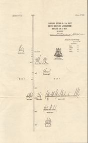
Map - UNITED HUSTLER'S & REDAN MINE - TRANSVERSE SECTIONS N & S OF SHAFT UNITED HUSTLER'S & REDAN MINE
... UNITED HUSTLER'S & REDAN MINE - TRANSVERSE SECTIONS N & S OF SHAFT UNITED HUSTLER'S & REDAN MINE...... Transverse Sections N & S of Shaft United Hustler's & Redan Mine...Transverse Sections N & S of Shaft United Hustler's & Redan Mine on the Hustler's Line of Reef Bulletin No 33, Plate No XXX. ...MINING Parish Map United Hustler's & Redan Mine Transverse Sections N & S of Shaft United Hustler's & Redan Mine Hustler's Line of Reef Transverse Sections N & S of Shaft United Hustler's & Redan Mine on the Hustler's Line of Reef Bulletin No 33, Plate No XXX. ...Transverse Sections N & S of Shaft United Hustler's & Redan Mine on the Hustler's Line of Reef Bulletin No 33, Plate No XXX. Map shows some of the stone encountered on the levels and depth. Geological Survey of Victoria emblem and signed by H A Whitdan, Underground Survey Office Bendigo, September 1913.mining, parish map, united hustler's & redan mine, transverse sections n & s of shaft united hustler's & redan mine, hustler's line of reef -
 Bendigo Historical Society Inc.
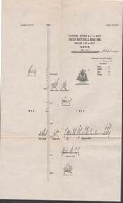
Map - STRUGNELL COLLECTION: UNITED HUSTLER'S & REDAN MINE, September 1913
... Map, Transverse Sections N. & S. Of shaft, United Hustler's & Redan Mine, Hustler's Line of Reef, Bendigo. ...MAP Bendigo hustler's & redan mine Underground Survey Office, Bendigo. Map, Transverse Sections N. & S. Of shaft, United Hustler's & Redan Mine, Hustler's Line of Reef, Bendigo. ...Map, Transverse Sections N. & S. Of shaft, United Hustler's & Redan Mine, Hustler's Line of Reef, Bendigo. Plate No. XXX (30).Bulletin No 33 Signed H.A.Whitelaw. Drawing shows the vertical shaft descending to over 976 feet and appears to show samples of connecting horizontal shafts with their respective mineral contentsUnderground Survey Office, Bendigo.map, bendigo, hustler's & redan mine -
 Bendigo Historical Society Inc.
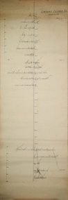
Plan - Confidence Extended Co, Unknown
... N. shaft is at 1403ft. After making- allowances for the northerly pitch of the country, it is calculated that the main shaft would require to be deepened about 600ft. in order to pick lip the continuation of the reef being opened up successfully in the "Windmill Hill mine. 'Bendigo Advertiser' 7th May 1909. gold mining gold Bendigo transverse section ...The Confidence Extended Gold Mine was located near the corner of Taylor Street and Upper California Road, Long Gully. CONFIDENCE EXTENDED This company, as will be soon by the plan, has a large lease holding on the extension of the line. The main shaft, which is in a fairly central position, is down about 2350 ft., while the lowest level at the N. shaft is at 1403ft. After making- allowances for the northerly pitch of the country, it is calculated that the main shaft would require to be deepened about 600ft. in order to pick lip the continuation of the reef being opened up successfully in the "Windmill Hill mine. 'Bendigo Advertiser' 7th May 1909.Printed in black text on top of plan: 'Confidence Extended Co'. Handwritten name inscribed: 'N.Cundy, 8.2.10'. Transverse section of mine shaft, annotated with geological features and depths. Plan forms part of the Margaret Roberts Collection.gold mining, gold, bendigo, transverse section, confidence extended gold mine -
 Bendigo Historical Society Inc.
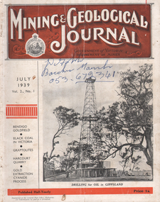
Journal - Kairn Collection: Mining and Geological Journal, July 1939
... Caldwell, District Geologist, shows a longitudinal section of a portion of the Sheepshead line of reef; transverse section of the New Chum and North Deborah syncline reefs. Article page 25: 'Bendigo (N. 2) District' J.B. ...Caldwell, District Geologist, shows a longitudinal section of a portion of the Sheepshead line of reef; transverse section of the New Chum and North Deborah syncline reefs. Article page 25: 'Bendigo (N. 2) District' J.B. ...Sixty-eight page journal. On front cover: 'Mining & Geological Journal, Government of Victoria, Department of Mines., July 1939, No. 1. Black and white image of oil drill rig in Gippsland on right hand side of cover. Article, page 16, 'Axedale Mine, Axedale'. Pages 21 to 23: ''Notes on the Bendigo Goldfield', by J.J. Caldwell, District Geologist, shows a longitudinal section of a portion of the Sheepshead line of reef; transverse section of the New Chum and North Deborah syncline reefs. Article page 25: 'Bendigo (N. 2) District' J.B. Justice, Inspector.On front cover in blue biro ' D. (illegible) Bacchus Marsh 053 672341'bendigo, mining, gold mining, black coal in victoria, graptolites, harcourt quarry, gold extraction, cyanide process, axedale mine, north deborah mine, central deborah mine, new chum syncline, nell gwynne, central nell gwynne, north virginia, south deborah, north nell gwynne, hercules, south virginia, south costerfield gold and antimony co., gold dumps pty ltd., golden square, antimony, brauman and sons, napoleon gully, sedwick, lewis and morrow
