Showing 152 items matching " water problems"
-
 Bendigo Historical Society Inc.
Document - DRAINAGE PROBLEMS - WATER PROBLEMS
... DRAINAGE PROBLEMS - WATER PROBLEMS...... Water Problems... - WATER PROBLEMS ...Two handwritten pages with extracts from the Bendigo Advertiser Mining Intelligence. Notes mention making arrangements with other mines to resume bailing, Victoria Quartz still shaft sinking despite strong flow of water, Lansell's 180 preparing to bail water from the deep levels, so that the Victoria Quartz may continue shaft sinking and finishing cutting of plat at 4454 ft. Also a weather report on the 14/6/1910. From the Albert Richardson Mining History Collection.gold, drainage problems, drainage problems, water problems, bendigo advertiser mining intelligence 18/4/1910, 9/5/1910, 23/5/1910, 30/5/1910, 6/6/1910, 13/6/1910, victoria quartz, lazarus coy, lansell's 180, albert richardson -
 Clunes Museum
Document - DOCUMENTS/CLUNES WATER, 1983
... CLUNES HAS HAD WATER PROBLEMS DURING THE AGES AND THESE ARE NEWSPAPER REPORTS 1983 AND MEMORANDUM FOR THE HONORABLE THE MINISTER OF MINES...NEWSPAPER CUTTINGS. CLUNES WATER PROBLEMS AND REPORTS AND ARTICLES REMOVED FROM THE BALLARAT COURIER 1983 AND GOVERNMENT REPORT 1873...CLUNES WATER PROBLEMS AND REPORTS AND ARTICLES REMOVED FROM THE BALLARAT COURIER 1983 AND GOVERNMENT REPORT 1873 Document DOCUMENTS/CLUNES WATER ...CLUNES HAS HAD WATER PROBLEMS DURING THE AGES AND THESE ARE NEWSPAPER REPORTS 1983 AND MEMORANDUM FOR THE HONORABLE THE MINISTER OF MINESNEWSPAPER CUTTINGS. CLUNES WATER PROBLEMS AND REPORTS AND ARTICLES REMOVED FROM THE BALLARAT COURIER 1983 AND GOVERNMENT REPORT 1873local history, document, report, newspaper cutting, clunes water -
 Bendigo Historical Society Inc.
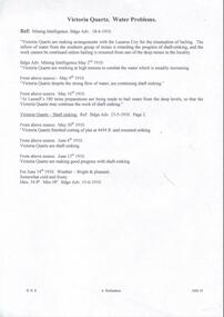
Document - DRAINAGE PROBLEMS - WATER IN NEW CHUM MINES
... DRAINAGE PROBLEMS - WATER IN NEW CHUM MINES...water level.' 'The plant is strong with abundance of steam space which would allow the firewood to be used economically under the barborous Cornish Boiler or wood-eaters'. Bgo Adv 14/7/1910. Document from Albert Richardson Collection of mining history. Document DRAINAGE PROBLEMS ...Handwritten copy of Bendigo Advertiser reports of water in New Chum Mines. (1) 'The water rose yesterday, 9 feet in the Victoria Quartz mine and now at 3215 ft. Bgo. Adv 6/7/1910 page 7. (2) 'New Chum Mines. Futile attempts to cope with water. Despite the fact that bailing is being carried on steadily, the water has risen 55 feet in the last 24 hours, and is now up to 3160 feet. New Chum Consolidated has since last week raised 327,000 galls, but the bailing has made no perceptible difference. The Lazarus to start on Monday.' Bgo Adv 9/7/1910 Page 9. (3) Letter to Adv by A. L.N. Excerpts. 'Bailing should have commenced at New Chum Railway.' 'The bulk of water is at South end. 3.5 million galls per month, divided between South Belle Vue, Eureka Extended and New Chum Railway.' 'In black and white, the Railway in the wet season, July last year with the aid of the Cornish Lift, raised 2.25 million galls, besides attending to those employed below.' 'Safe to say that 3.5 million galls per month could be raised from the present water level.' 'The plant is strong with abundance of steam space which would allow the firewood to be used economically under the barborous Cornish Boiler or wood-eaters'. Bgo Adv 14/7/1910. Document from Albert Richardson Collection of mining history.document, gold, drainage problems, new chum drainage association, water in new chum mines, victoria quartz, new chum consolidated, lazarus, new chum railway, south belle vue, eureka extended, cornish lift, bendigo advertiser 6/7/1910 page 7, bendigo advertiser 9/7/1910 page 9, bendigo advertiser 14/7/1910 -
 Friends of Ballarat Botanical Gardens History Group
Work on paper - The Black Swamp and Lake Wendouree's Water Supply. The Ballarat Courier,18/3/2006, The Lake in the Nineteenth Century and the Problems with Water, 18/3/2006
... The Lake in the Nineteenth Century and the Problems with Water....There is a brief history of the Lake including discussion of the problems with the water supply over the years and then in 2006 during the millenium drought....Water Supply John Garner Collection Gardens Ballarat p.1, top left, written in blue biro "Courier, 18/3,2006. 1 page, both sides of newsprint. p.1 is entitled "Our Love Affair with the Swamp". There is a coloured picture of the Swamp, top lefthand side of the page. Overleaf, "The Lake: it's a Dry Argument". There is a coloured picture of the Lake, top lefthand side of page and the bottom lines have been cut through. The Lake in the Nineteenth Century and the Problems ...There is a brief history of the Lake including discussion of the problems with the water supply over the years and then in 2006 during the millenium drought.The two articles give some perspective on longstanding concerns about the water supply for Ballarat and particularly Lake Wendouree.1 page, both sides of newsprint. p.1 is entitled "Our Love Affair with the Swamp". There is a coloured picture of the Swamp, top lefthand side of the page. Overleaf, "The Lake: it's a Dry Argument". There is a coloured picture of the Lake, top lefthand side of page and the bottom lines have been cut through.p.1, top left, written in blue biro "Courier, 18/3,2006.john garner, doctor john garner, ballarat botanic gardens, friends of ballarat botanical gardens, lake wendouree, francois cogne, black swamp, yuille's swamp., ballarat water supply, john garner collection, gardens, ballarat -
 Bendigo Historical Society Inc.
Document - DRAINAGE PROBLEMS - BURST WATER MAIN UNDER GARDEN GULLY SANDHEAP
... DRAINAGE PROBLEMS - BURST WATER MAIN UNDER GARDEN GULLY SANDHEAP...Problems... Burst Water Main under Garden Gully Sandheap...water race so they did not close down. Document from Albert Richardson Collection of mining history. Document DRAINAGE PROBLEMS - BURST WATER MAIN UNDER GARDEN GULLY SANDHEAP ...Handwritten notes from a Bendigo Advertiser report 7 Jan 1907. Three shifts of men working all Saturday and Sunday had not located the main. A large are of Eaglehawk and the City are without water. Had to timber a hole to a depth of 25 ft. Victoria Quartz, Windmill Hill, Needle, Confidence Ext'd, Princess Dagmar, Golden Age, Golden Pyke, Macduff, constellation, Gt Northern, (partly), Specimen Hill, Clarence, New Argus, Comet, Gt Central Victoria and Victoria Consols had to close because they had no water and five to six hundred men believed to be out of work. City Council will put water-carts on and supply residents free of charge. New Moon, South Moon, Virginia , Catherine and Devonshire mines get their water direct from the water race so they did not close down. Document from Albert Richardson Collection of mining history.gold, drainage problems, drainage problems, burst water main under garden gully sandheap, bendigo advertiser, 7/1/1907, victoria quartz, windmill hill, needle, confidence ext'd, princess dagmar, golden age, golden pyke, macduff, constellation, gt northern, (partly), specimen hill, clarence, new argus, comet, gt central victoria, victoria consols, north johnsons, johnson's reef, snobs hill line, new moon south moon, virginia, catherine, devonshire, albert richardson -
 Bendigo Historical Society Inc.
Document - NEW CHUM & VICTORIA LINES OF REEF - NEW CHUM RAILWAY MINE MANAGER'S REPORT 1880 - 84
... Items mentioned: telephones, mechanical breakdowns, air supply, trouble with flat ropes, water problems, leaning and testing boiler engines....Items mentioned: telephones, mechanical breakdowns, air supply, trouble with flat ropes, water problems, leaning and testing boiler engines. ...Handwritten excerpts from Mine Manager's Reports from January 1880 to May 1884. Mine Manager Mr. J Alderson. Items mentioned: telephones, mechanical breakdowns, air supply, trouble with flat ropes, water problems, leaning and testing boiler engines.document, gold, new chum & victoria lines of reef, new chum railway mine manager's report 1880 - 84, mr j alderson, o'rourke and henderson, allingham, aitkens, pandora, richard heals, flat ropes, young chum co, horwood's, old chum, harkness, crushing mill, g armstrong, roberts & sons, eureka coy -
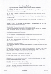
 Lions Club of Maldon Inc.
Book, A Concise History of Maldon and the Tarrangower Diggings, 1979
... Contents include early settlement, gold discovery in 1853, early water problems, public institutions. Mention of Chinese on Tarrangower, and German and Italian settlers. ...Contents include early settlement, gold discovery in 1853, early water problems, public institutions. Mention of Chinese on Tarrangower, and German and Italian settlers. maldon tarrangower gold victoria Book of 86 Pages A Concise History of Maldon and the Tarrangower Diggings Book Book Jeffrey Zilles Albert James WIlliams ...Concise historical record of events rather than people. Contents include early settlement, gold discovery in 1853, early water problems, public institutions. Mention of Chinese on Tarrangower, and German and Italian settlers. Book of 86 Pagesmaldon, tarrangower, gold, victoria -
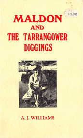
 Bendigo Historical Society Inc.
Newspaper - LONG GULLY HISTORY GROUP COLLECTION: WATER IN THE VICTORIA QUARTZ
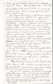
... Article mentions the water problem in the Victoria Quartz Mine and where they believed it was coming from. ...Article mentions the water problem in the Victoria Quartz Mine and where they believed it was coming from. ...BHS CollectionPhotocopy of a newspaper article titled Water Continues to Rise in the Victoria Quartz by James Lerk. Article mentions the water problem in the Victoria Quartz Mine and where they believed it was coming from. Also mentioned is the mining inspector William Abraham. There is a short history of his working life up to the time of his qualifying as a mine manager after studying part-time for ten years at the Bendigo School of Mines. There is a dark photo of William and his horse.bendigo, history, long gully history group, the long gully history group - water in the victoria quartz, james lerk, victoria quartz, william abraham, new chum reef, matthew stevens, south bellevue, new chum and victoria mine, lazarus, new chum drainage association, william abraham snr, druid, mary kane, lady miltoa, ballarat freehold company, the wallaby, richard grenfell, bendigo advertiser, bendigo school of mines, confidence extended mine, george ellis -
Whitehorse Historical Society Inc.
Article, Flood plan, 1993
... $100,000 will be spent by Melbourne Water to solve flooding problems in the Fulton Road area....Whitehorse Historical Society Inc. 2-10 Deep Creek Road Mitcham melbourne Melbourne Water Fulton Road Blackburn South Drainage $100,000 will be spent by Melbourne Water to solve flooding problems in the Fulton Road area. $100,000 will be spent by Melbourne Water to solve flooding problems in the Fulton Road area. ...$100,000 will be spent by Melbourne Water to solve flooding problems in the Fulton Road area.$100,000 will be spent by Melbourne Water to solve flooding problems in the Fulton Road area.$100,000 will be spent by Melbourne Water to solve flooding problems in the Fulton Road area.melbourne water, fulton road, blackburn south, drainage -
 Orbost & District Historical Society
black and white photograph, late nineteenth - early 20th century
... The 'Ace of Clubs' was eventually closed as the company was unable to cope with the rising water problem. (information Newsletter February 2011 - John Phillips)...The 'Ace of Clubs' was eventually closed as the company was unable to cope with the rising water problem. (information Newsletter February 2011 - John Phillips) This is a pictorial record of mining methods in East Gippsland in the late 19th century to early 20th century. mining-gold mining-east-gippsland Cadwallader-Malina-Mine gold-mining-battery on back - "Cadwallader's Malina Mine" A black / white photograph of a mine. ...Gold was found at Club Terrace in 1896. One of the best finds at Club Terrace was the 'Ace of Clubs' mine which was later sold to the Mallina Gold Mining Company. Syd Cadwallader was appointed manager of the company. The gold was smelted and brought to Orbost on horseback. The only protection against thieves was a revolver and riding crop, which the manager always carried. The 'Ace of Clubs' was eventually closed as the company was unable to cope with the rising water problem. (information Newsletter February 2011 - John Phillips)This is a pictorial record of mining methods in East Gippsland in the late 19th century to early 20th century.A black / white photograph of a mine. It is in a bush setting. Men are standing in front of timber mine constructions. Some wooden buildings can be seen behind the structureson back - "Cadwallader's Malina Mine"mining-gold mining-east-gippsland cadwallader-malina-mine gold-mining-battery -
Port Melbourne Historical & Preservation Society
Book - Port Melbourne Council, J Mounsey, Sanitary Inspector, Sanitary Inspectors Report Book, 1923 - 1929
... Detailing sampling food for tests, Pure Food Act, Test weights and measures incuding those of wood merchants (Coal and Firewood Act), Prosecutions, water supply problems....Detailing sampling food for tests, Pure Food Act, Test weights and measures incuding those of wood merchants (Coal and Firewood Act), Prosecutions, water supply problems. Sanitary Inspectors Report Book Book Port Melbourne Council J Mounsey, Sanitary Inspector ...Sanitary Inspector's Reports to Port Melbourne Council 1905-1912. Detailing sampling food for tests, Pure Food Act, Test weights and measures incuding those of wood merchants (Coal and Firewood Act), Prosecutions, water supply problems.local government - town of port melbourne, local government - city of port melbourne, environmental issues, health - general health, business and traders, industry, nightsoil, built environment, livestock, engineering - canals and drainage, james mounsey - sanitary inspector -
 Orbost & District Historical Society
black and white photograph, 1896 - 1905
... The 'Ace of Clubs' was eventually closed as the company was unable to cope with the rising water problem. (information Newsletter February 2011 - John Phillips) ...The 'Ace of Clubs' was eventually closed as the company was unable to cope with the rising water problem. (information Newsletter February 2011 - John Phillips) This is a pictorial record of gold mining in East Gippsland during the late 19th - early 20th century. mining-Club-Terrace Mallina-Mine battery-mines gold-mining-east-ippsland A black / white photograph of an operational mine with scaffolding and bridges. ...This photograph shows the Battery Goldmine at Club Terrace from 1896 - 1905. Gold was found at Club Terrace in 1896. One of the best finds at Club Terrace was the 'Ace of Clubs' mine which was later sold to the Mallina Gold Mining Company. Syd Cadwallader was appointed manager of the company. The gold was smelted and brought to Orbost on horseback. The only protection against thieves was a revolver and riding crop, which the manager always carried. The 'Ace of Clubs' was eventually closed as the company was unable to cope with the rising water problem. (information Newsletter February 2011 - John Phillips) This is a pictorial record of gold mining in East Gippsland during the late 19th - early 20th century.A black / white photograph of an operational mine with scaffolding and bridges. There are several men standing in front.mining-club-terrace mallina-mine battery-mines gold-mining-east-ippsland -
 Orbost & District Historical Society
black and white photograph, 1895 - 1905
... The 'Ace of Clubs' was eventually closed as the company was unable to cope with the rising water problem. (information Newsletter February 2011 - John Phillips)...The 'Ace of Clubs' was eventually closed as the company was unable to cope with the rising water problem. (information Newsletter February 2011 - John Phillips) This is a pictorial record of gold mining in East Gippsland during the late 19th - early 20th century. gold-mining-battery-mine club-terrace A black / white photograph of a mine site with timber mine constructions spread around. ...This photograph shows the Battery Goldmine at Club Terrace from 1896 - 1905. Gold was found at Club Terrace in 1896. One of the best finds at Club Terrace was the 'Ace of Clubs' mine which was later sold to the Mallina Gold Mining Company. Syd Cadwallader was appointed manager of the company. The gold was smelted and brought to Orbost on horseback. The only protection against thieves was a revolver and riding crop, which the manager always carried. The 'Ace of Clubs' was eventually closed as the company was unable to cope with the rising water problem. (information Newsletter February 2011 - John Phillips)This is a pictorial record of gold mining in East Gippsland during the late 19th - early 20th century.A black / white photograph of a mine site with timber mine constructions spread around. There is a river in the foreground. Some wooden buildings can be seen in the background.gold-mining-battery-mine club-terrace -
 Bendigo Historical Society Inc.
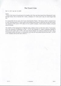
Document - TYSON'S LINE
... It is noteworthy for two mines, the Tyson's Reef and the Thanet. Water was a problem on this line. A Worthington pump, which was installed to combat the water, fell down the shaft. ...It is noteworthy for two mines, the Tyson's Reef and the Thanet. Water was a problem on this line. A Worthington pump, which was installed to combat the water, fell down the shaft. ...Hand written notes and typed copy . The Tyson's Line, known for a great part of its length as the Flora. It is noteworthy for two mines, the Tyson's Reef and the Thanet. Water was a problem on this line. A Worthington pump, which was installed to combat the water, fell down the shaft. Second page is missing. Ref: A. M. S. Sp. Ed. 1-6-1899. Notes prepared by Albert Richardson.mine, gold, tyson's line and flora, tyson's line, the flora, tyson's reef mine, thanet mine, eldorado co, worthington pump, a m s sp ed 1/6/1899 -
 Bendigo Historical Society Inc.
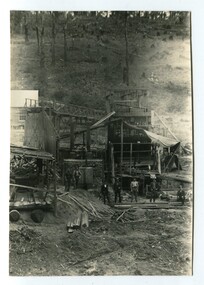
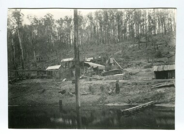
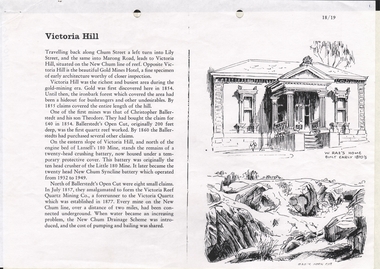
Document - LONG GULLY HISTORY GROUP COLLECTION: VICTORIA HILL
... It later became the twenty head New Chum Syncline Battery. Water became a problem and the New Chum Drainage Scheme was introduced and the cost of pumping and bailing was shared between the mines....It later became the twenty head New Chum Syncline Battery. Water became a problem and the New Chum Drainage Scheme was introduced and the cost of pumping and bailing was shared between the mines. ...3 Pages titled Victoria Hill. On one side is a sketch of W Rae's Home built in the early 1870's and Rae's Open Cut. Mentioned is a short history of Victoria Hill and the mine of Christopher Ballerstadt and his son Theodore. The remains of a 20 head crushing battery, which was originally the ten head crusher of the Little 180 Mine remains. It later became the twenty head New Chum Syncline Battery. Water became a problem and the New Chum Drainage Scheme was introduced and the cost of pumping and bailing was shared between the mines.bendigo, history, long gully history group, the long gully history group - victoria hill, gold mines hotel, christopher ballerstedt, theodore ballerstadt, ballerstadt's open cut, lansell's 180 mine, little 180 mine, new chum syncline battery, victoria reef quartz mining co, victoria quartz, new chum drainage system, w rae's home, rae's open cut -
 Bendigo Historical Society Inc.
Document - SOUTH BELLE VUE MINE - FIRE AT THE SOUTH BELLE VUE & TRUE BLUE MINES
... Handwritten copy of a report in the Bendigo Advertiser 19th, 20th and 21st August 1894 of an explosion and fire at the South Belle Vue Mine Enginehouse. Water pressure was a problem with their fire fighting efforts. ...Coy Mr Cottie Handwritten copy of a report in the Bendigo Advertiser 19th, 20th and 21st August 1894 of an explosion and fire at the South Belle Vue Mine Enginehouse. Water pressure was a problem with their fire fighting efforts. ...Article transcribed from the Bendigo Advertiser, 20th August 1986.Handwritten copy of a report in the Bendigo Advertiser 19th, 20th and 21st August 1894 of an explosion and fire at the South Belle Vue Mine Enginehouse. Water pressure was a problem with their fire fighting efforts. While this was happening a messenger came to say the Engine house at the True Blue Mine was also on fire. Both fires were believed to be deliberately lit. A resident saw a man carrying a lighted torch through the bush. Notes prepared by Albert Richardson.document, gold, south belle vue mine, south belle vue mine, true blue mine, fire at the south belle vue & true blue mines, angus kennedy, mr r woods, capt houston, national ins. coy, mr cottie -
 Bendigo Historical Society Inc.
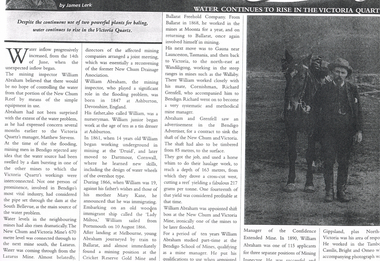
Newspaper - LONG GULLY HISTORY GROUP COLLECTION: WATER CONTINUES TO RISE IN THE VICTORIA QUARTZ
... Water Continues to Rise in the Victoria Quartz by James Lerk. Article mentions William Abraham who was the mining inspector, who played a significant role in the flooding problem. ...Water Continues to Rise in the Victoria Quartz by James Lerk. Article mentions William Abraham who was the mining inspector, who played a significant role in the flooding problem. ...Photo of a newspaper article titled Water Continues to Rise in the Victoria Quartz by James Lerk. Article mentions William Abraham who was the mining inspector, who played a significant role in the flooding problem. Water levels had risen dramatically. Water flowed from one mine to another where they were connected. Article also mentions Abraham's birthplace, his early start to work at the age of 10 as a tin dresser at Ashburton, Devonshire, England and his working life after he migrated to Australia at the age of 19. His career in Australia is also mentioned. The article is accompanied by a photo of Abraham with his horse.bendigo, history, long gully history group, the long gully history group - water continues to rise in the victoria quartz, james lerk, william abraham, new chum reef, matthew stevens, south bellevue, new chum and victoria mine, lazarus mine, new chum drainage association, william abraham snr, mary kane, lady miltoa (ship), cricket reserve gold mine, ballarat freehold company, wallaby mine, richard grenfell, bendigo advertiser, bendigo school of mines, confidence extended mine -
 Narre Warren and District Family History Group
Book, Narre Warren & District Family History Group Inc, Casey Cardinia Collection - Selected articles from the West Gippsland Trader - Volume 2, 2021
... 3 Jul 2014 The Magnificent Snowy 14 Aug 2014 Two Gems in the Hills 19 Jun 2014 The Towns Down the Line 27 Feb 2014 State School 2502, Longwarry 18 Sep 2014 Lakes a Natural Fishing Ground 15 May 2014 Police Down the Ages 22May 2014 Iron Horse Came at a Walk 29 May 2014 Prom’s Early Attraction 12 Jun 2014 A Brief History of Meeniyan 5 Jun 2014 Ride on the Old Great Southern 26 Jun 2014 When Victoria Police Went on Strike 23 Apr 2015 Grandma’s Family Lost Heavily 11 Jun 2015 A Rail Journey Almost to Orbost 28 May 2015 Second Battle of Hastings 4 Jun 2015 Dandenong to Trafalgar by Train 18 Jun 2015 The Travelling Picture Man 19 Feb 2015 Water was a Problem 5 Feb 2015 Sandy Point Return Invokes Memories 24 Oct 2013 Lyrebirds Nesting in Trees? ...3 Jul 2014 The Magnificent Snowy 14 Aug 2014 Two Gems in the Hills 19 Jun 2014 The Towns Down the Line 27 Feb 2014 State School 2502, Longwarry 18 Sep 2014 Lakes a Natural Fishing Ground 15 May 2014 Police Down the Ages 22May 2014 Iron Horse Came at a Walk 29 May 2014 Prom’s Early Attraction 12 Jun 2014 A Brief History of Meeniyan 5 Jun 2014 Ride on the Old Great Southern 26 Jun 2014 When Victoria Police Went on Strike 23 Apr 2015 Grandma’s Family Lost Heavily 11 Jun 2015 A Rail Journey Almost to Orbost 28 May 2015 Second Battle of Hastings 4 Jun 2015 Dandenong to Trafalgar by Train 18 Jun 2015 The Travelling Picture Man 19 Feb 2015 Water was a Problem 5 Feb 2015 Sandy Point Return Invokes Memories 24 Oct 2013 Lyrebirds Nesting in Trees? ...Folder containing a table of contents and a selection of articles on Gippsland History by John Wells in the West Gippsland Trader Volume 2. The date the articles were published, and title of articles are listed below. 19 Jul 2012 Gembrook - an Attractive Little Town 7 Jun 2012 Getting Rid of the Wood 21 Mar 2013 Getting Into Orbost 13 Dec ? Metung - A BEnd in the River 20 Sep 2012 The Royal Victorian Navy 6 Dec 2012 Tree Ferns to Blackberries 22 Nov 2012 Nowa Nowa Arm and Boggy Creek 18 Oct 2012 Home of the Baw Baw Frog 1 Nov 2012 Clearing the Hills 11 Oct 2012 The Loss of the Monumental City 4 Oct 2012 The Waterloo Township 13 Sep 2012 Birth of the Shire of Morwell 27 Sep 2012 George Black and Tarwin Meadows 9 Aug 2012 The Forgotten Corner of Gippsland 27 Mar 2008 Thomas William Harrison’s Family 3 Jul ? Railway was Enormous Value to Swamp Country 19 Jun 2008 The Narre Warren Reserve Gates 12 Jun 2008 Heavy Harry is a Pretty Crook Giant 2 May ? Small Settlements on a Long Gippsland Track 5 Jun 2008 Land of Bullumwaal ot “Two Spears” 29 May 2008 Bigger Stops on a Long Road 15 May 2008 Crossing the Beautiful Snowy River 17 Apr 2008 I Remember Uncle Jack aqs an Old Man with Something Wrong 25 Jun 2009 The Murder of Cornelius Green 2 Jul 2009 Captain James Cook was too Late 5 Sep 2013 Oil and the Gippsland Lakes 18 Jun 2009 The Suburbs Around Sale 13 May 2010 The Boag Generations go on and on in Gippsland 27 May 2010 Underwater Coal at Yallourn Open Cut 4 Nov 2010 Narracan - the Aboriginal Name for Crow 23 Apr 2009 Driving Along the Omeo Track 2 Dec 2010 Remembering Those Old Wives’ Tales that we all Grew up with 16 Apr 2009 Myrtlebank, the Lost Suburb 16 Dec 2010 The Tragedy of the Loch Ard 9 Dec 2010 The Latrobe River Wharf on the East Bank 2 Jun 2011 Stony Creek Township’s Quiet Past 17 Mar 2011 William Barak Saw the Whites Take Over 5 May 2011 The Squatters’ Names Still Here 12 May 2011 The Diary of C.A.Ramsden (part one) 26 May 2011 South Coast Towns, 1891 19 May 2011 The Second Part of C.A.Ramsden’s Diary 28 Apr 2011 Squatter Names Still Remain on our Maps 13 Oct 2011 The Resting Place of 1131 Australians 29 Sep 2011 The Mitchell Valley Hopfields Oct 6 Lest We Forget - Lijssenthoek 10 Nov 2011 The Kurnai Men UNKNOWN The Returning of Captain Joe McLaughlin 6 Jun 2013 The Marlo Plains 16 May 2013 Bain’s Border Hotel 23 May ? The Mystery Map 30 May 2013 Finding a Road to the Jordan 4 Apr 2013 Rick Solves Mystery of American Captain 2 May ? The Haunted Hills - Tall Story or Truth? 18 Apr ? Interesting Times 15 Aug 2013 Remembering the Good Times 11 Dec 2014 The Old Sale Road - an Important Link 26 Mar 2015 Difficult to Know the Real Story 27 Nov 2014 The State’s Real Birthday 12 Sep 2013 The Herald 1925 2 Oct 2014 Beacons of Hope 9 Oct 2014 The Joys of Parenthood 6 Nov 2014 Aboriginal Life in Gippsland 30 Oct 2014 Growing up in Gippsland - Harriett Quigley 26 Sep 2013 The McHaffie Diary 19 Sep 2013 Outtrim - Once a Boom Town 10 Oct 2013 Happy Hundredth Birthday 4 Sep 2014 Many Towns Simply Disappeared 17 Jul 2014 Long Distance Farmer 25 Sep 2014 Sam Anderson - Gippsland’s First Farmer 28 Aug 2014 Local Oil 90 Years Ago 6 Mar 2014 A Fiery Summer - 1898 20 Feb 2014 The Corduroy Roads 8 May 2014 The Darkness Within 13 Mar ? Draining the Moe Swamp 1 May 2014 Any Ideas on Old Cannon? 3 Jul 2014 The Magnificent Snowy 14 Aug 2014 Two Gems in the Hills 19 Jun 2014 The Towns Down the Line 27 Feb 2014 State School 2502, Longwarry 18 Sep 2014 Lakes a Natural Fishing Ground 15 May 2014 Police Down the Ages 22May 2014 Iron Horse Came at a Walk 29 May 2014 Prom’s Early Attraction 12 Jun 2014 A Brief History of Meeniyan 5 Jun 2014 Ride on the Old Great Southern 26 Jun 2014 When Victoria Police Went on Strike 23 Apr 2015 Grandma’s Family Lost Heavily 11 Jun 2015 A Rail Journey Almost to Orbost 28 May 2015 Second Battle of Hastings 4 Jun 2015 Dandenong to Trafalgar by Train 18 Jun 2015 The Travelling Picture Man 19 Feb 2015 Water was a Problem 5 Feb 2015 Sandy Point Return Invokes Memories 24 Oct 2013 Lyrebirds Nesting in Trees? 12 Mar 2015 Supplying Melbourne’s Water 9 Aug 2015 They Shall Not Grow Old as we That Are Left 9 Jul 2015 National Parks a Valuable Resource 11 Sep 2014 Living Through the Best and the Worst 12 Feb 2015 Fishing is Part of Port’s History 26 Feb 2015 Chance Lost to Eliminate Rabbits 5 Mar 2015 Bloomfield - End of the Line, in a Way 11 Jul ? Emerald Primary School 22 Aug 2013 The Heartbreak Hills 17 Oct 2013 Port Albert, Land of Elephants 14 Nov 2013 Bullumwaal Land of Two Spears 28 Nov 2013 Coalville - the Forgotten Mine 5 Dec 2013 Early Travel with the Bishop 12 Dec 2013 Bishop Perry in Gippsland 19 Dec 2013 The Great Sale Goldfields Hoax 20 Mar 2014 A Chance to Dazzle the Kids 27 Mar 2014 More of Those Creeks and Rivers 3 Apr 2014 The Arctocephalus is With us Still 10 Apr 2014 Upper Yarra Dam had an Early Start UNKNOWN Harkaway’s Colorful History Contains Some Doubtful Tales UNKNOWN Berwick and the Peninsula in 1886non-fictiongippsland lakes, emerald primary school, meeniyan, upper yarra dam -
 Narre Warren and District Family History Group
Book, Narre Warren & District Family History Group Inc, Casey Cardinia Collection - Selected articles from the West Gippsland Trader - Volume 1, 2010
... 3 Jul 2014 The Magnificent Snowy 14 Aug 2014 Two Gems in the Hills 19 Jun 2014 The Towns Down the Line 27 Feb 2014 State School 2502, Longwarry 18 Sep 2014 Lakes a Natural Fishing Ground 15 May 2014 Police Down the Ages 22May 2014 Iron Horse Came at a Walk 29 May 2014 Prom’s Early Attraction 12 Jun 2014 A Brief History of Meeniyan 5 Jun 2014 Ride on the Old Great Southern 26 Jun 2014 When Victoria Police Went on Strike 23 Apr 2015 Grandma’s Family Lost Heavily 11 Jun 2015 A Rail Journey Almost to Orbost 28 May 2015 Second Battle of Hastings 4 Jun 2015 Dandenong to Trafalgar by Train 18 Jun 2015 The Travelling Picture Man 19 Feb 2015 Water was a Problem 5 Feb 2015 Sandy Point Return Invokes Memories 24 Oct 2013 Lyrebirds Nesting in Trees? ...3 Jul 2014 The Magnificent Snowy 14 Aug 2014 Two Gems in the Hills 19 Jun 2014 The Towns Down the Line 27 Feb 2014 State School 2502, Longwarry 18 Sep 2014 Lakes a Natural Fishing Ground 15 May 2014 Police Down the Ages 22May 2014 Iron Horse Came at a Walk 29 May 2014 Prom’s Early Attraction 12 Jun 2014 A Brief History of Meeniyan 5 Jun 2014 Ride on the Old Great Southern 26 Jun 2014 When Victoria Police Went on Strike 23 Apr 2015 Grandma’s Family Lost Heavily 11 Jun 2015 A Rail Journey Almost to Orbost 28 May 2015 Second Battle of Hastings 4 Jun 2015 Dandenong to Trafalgar by Train 18 Jun 2015 The Travelling Picture Man 19 Feb 2015 Water was a Problem 5 Feb 2015 Sandy Point Return Invokes Memories 24 Oct 2013 Lyrebirds Nesting in Trees? ...Folder containing a table of contents and a selection of articles on Gippsland History by John Wells in the West Gippsland Trader Volume 1. The date the articles were published, and title of articles are listed below. 30 Oct 1997 Noojee Railway Line is an Engineering Classic 06 Nov 1997 Railways were a kiss of life for small settlements 13 Nov 1997 Erica was a timber and railway town 20 Nov 1997 People fought for railway line through to Stratford 27 Nov 1997 Tiny towns on the Wonthaggi line Vol 16 No 50 Cobungra station has some wild and beautiful country Vol 16 No 51 The explorers we have forgotten Vol 17 No 30 Hallam store became a place for men to gather 14 Feb 2002 Charlie Styles and his dull grey bedford bus Vol 26 No 10 Southern Community names 03 Aug 2006 A bit more Cloverlea 28 Sep 2006 Many airlines were keen to link wide brown land 26 Oct 2006 The ‘run’ at Top Plain 02 Nov 2006 Briagolong and the Garden of Eden 09 Nov 2006 I found a treasure in a milk bar 16 Nov 2006 Got five bob in your pocket, or should I say fifty cents? 23 Nov 2006 Trains were important in developing Gippsland 30 Nov 2006 The main line into Gippsland 07 Dec 2006 Alfred Howitt was a great man who deserves recognition Dec 2006? Christmas again? Already? 15 Feb 2007 The Great Southern Railway 08 Mar 2007 Expectations about water quality have changed since the old days 29 Mar 2007 Navigating by tree tops 12 Apr 2007 The Gippsland railway branch lines were very important in many ways 26 Apr 2007 Some community names from our northern hills 10 May 2007 Community names at the eastern end 24 May 2007 A shorter railway with big tonnages 31 May 2007 Cerberus was the guard dog 07 Jun 2007 Suburban stations in Gippsland 14 Jun 2007 How many Longwarry schools were there? 21 Jun 2007 Traralgon run was Hobson’s choice 28 Jun 2007 Maiden and Mormon and Happy Go Lucky 05 Jul 2007 Consider the humble rabbit trap 12 Jul 2007 Five acre blocks are everywhere 26 Jul 2007 Fencing, but not the Olympic variety 02 Aug 2007 Hanging the barbed wire fences 09 Aug 2007 Collecting and keeping the tucker we gathered 23 Aug 2007 The Longwarry Primary School itself 30 Aug 2007 Surveyors did it hard down Poowong way 06 Sep 2007 Back to the Poowong story 13 Sep 2007 A “think piece” or an indulgence? 20 Sep 2007 Longwarry “extra late final” 04 Oct 2007 Platina’s gone but not forgotten 11 Oct 2007 Robert Nield – Murray is back at it 18 Oct 2007 Spetts’ cottage at Walhalla 25 Oct 2007 Across the Alps to Omeo 08 Nov 2007 Where the gold lies deep in settlements that died 15 Nov 2007 Mines aplenty in the Walhalla area 22 Nov 2007 The other Violet Town – Jolly’s 29 Nov 2007 Mallacoota archaeology 06 Dec 2007 The Cassilis township or call it a settlement 13 Dec 2007 George Bass missed French Island 08 Feb 2008 David Mickle relates many stories of railway accidents 11Sep 2008 Lord Howe has a long history 18 Sep 2008 Quarry Hills important link for Berwick 25 Sep 2008 Tall ships, short ships, schooners and sloops 26 Jun 2008 We find Yanakie Jack again 03 Jul 2008 The well known Baw Baw Track 10 Jul 2008 Land of the moon? 07 Aug 2008 I loved eeling in the Tarago River 14 Aug 2008 Don’t let the red steer loose 28 Aug 2008 Yes, there is a place called Jumbuk 04 Sep 2008 The land of the big trees 23 Oct 2008 Still looking for Gippsland’s first town 13 Nov 2008 Journey to the bowels of the earth 30 Oct 2008 For King and Country – J.M. Laidlaw 06 Nov 2008 Jesse Huggett lived an adventurous life 22 Nov 2008 Churchill Island, yet again 04 Dec 2008 Bowman’s Track – if we can find it 11 Dec 2008 Draining of the great Koo Wee Rup Swamp 18 Dec 2008 The swampies had a go 02 Apr 2009 Looking for natural gas not offshore oil 21 Aug 2008 The Dreaded Summer Wildfire 17 Jul 2008 The Tangel (or Tanjil) hills District 7 Feb 2012 The Tanjil Area Goldrush 29 Aug 2013 Saddled and Spurred 9 Feb 2012 Many Racecourses Have Disappeared 16 Feb 2012 Fraser’s Hotel in Glenmaggie 23 Feb 2012 “Nothing Today, Jack!” on the Berwick Hill 1 Mar 2012 The Schnapper Point Line 8 Mar 2012 The Imaginary Town of Tambo 22 Mar 2012 The Tanjil Story Part One 15 Mar 2012 Inverloch Served Mosquito Fleet of Mis-Matched Boats 21 Jun 2012 The Last Bits of the Line 29 Mar 2012 “Gold Rush” to the Tanjil Area led to Reef Mining Companies 16 Aug 2012 New Life for Old Port Welshpool? 30 Aug 2012 The Capital of South Gippsland 28 Jun 2012 The Last Bits of the Line 5 Jul 2012 Ferdinand Von Mueller - a Man of Knowledge 12 Jul 2012 Stones in the Creek 19 Jul 2012 Gembrook - an Attractive Little Town 7 Jun 2012 Getting Rid of the Wood 21 Mar 2013 Getting Into Orbost 13 Dec ? Metung - A BEnd in the River 20 Sep 2012 The Royal Victorian Navy 6 Dec 2012 Tree Ferns to Blackberries 22 Nov 2012 Nowa Nowa Arm and Boggy Creek 18 Oct 2012 Home of the Baw Baw Frog 1 Nov 2012 Clearing the Hills 11 Oct 2012 The Loss of the Monumental City 4 Oct 2012 The Waterloo Township 13 Sep 2012 Birth of the Shire of Morwell 27 Sep 2012 George Black and Tarwin Meadows 9 Aug 2012 The Forgotten Corner of Gippsland 27 Mar 2008 Thomas William Harrison’s Family 3 Jul ? Railway was Enormous Value to Swamp Country 19 Jun 2008 The Narre Warren Reserve Gates 12 Jun 2008 Heavy Harry is a Pretty Crook Giant 2 May ? Small Settlements on a Long Gippsland Track 5 Jun 2008 Land of Bullumwaal ot “Two Spears” 29 May 2008 Bigger Stops on a Long Road 15 May 2008 Crossing the Beautiful Snowy River 17 Apr 2008 I Remember Uncle Jack aqs an Old Man with Something Wrong 25 Jun 2009 The Murder of Cornelius Green 2 Jul 2009 Captain James Cook was too Late 5 Sep 2013 Oil and the Gippsland Lakes 18 Jun 2009 The Suburbs Around Sale 13 May 2010 The Boag Generations go on and on in Gippsland 27 May 2010 Underwater Coal at Yallourn Open Cut 4 Nov 2010 Narracan - the Aboriginal Name for Crow 23 Apr 2009 Driving Along the Omeo Track 2 Dec 2010 Remembering Those Old Wives’ Tales that we all Grew up with 16 Apr 2009 Myrtlebank, the Lost Suburb 16 Dec 2010 The Tragedy of the Loch Ard 9 Dec 2010 The Latrobe River Wharf on the East Bank 2 Jun 2011 Stony Creek Township’s Quiet Past 17 Mar 2011 William Barak Saw the Whites Take Over 5 May 2011 The Squatters’ Names Still Here 12 May 2011 The Diary of C.A.Ramsden (part one) 26 May 2011 South Coast Towns, 1891 19 May 2011 The Second Part of C.A.Ramsden’s Diary 28 Apr 2011 Squatter Names Still Remain on our Maps 13 Oct 2011 The Resting Place of 1131 Australians 29 Sep 2011 The Mitchell Valley Hopfields Oct 6 Lest We Forget - Lijssenthoek 10 Nov 2011 The Kurnai Men UNKNOWN The Returning of Captain Joe McLaughlin 6 Jun 2013 The Marlo Plains 16 May 2013 Bain’s Border Hotel 23 May ? The Mystery Map 30 May 2013 Finding a Road to the Jordan 4 Apr 2013 Rick Solves Mystery of American Captain 2 May ? The Haunted Hills - Tall Story or Truth? 18 Apr ? Interesting Times 15 Aug 2013 Remembering the Good Times 11 Dec 2014 The Old Sale Road - an Important Link 26 Mar 2015 Difficult to Know the Real Story 27 Nov 2014 The State’s Real Birthday 12 Sep 2013 The Herald 1925 2 Oct 2014 Beacons of Hope 9 Oct 2014 The Joys of Parenthood 6 Nov 2014 Aboriginal Life in Gippsland 30 Oct 2014 Growing up in Gippsland - Harriett Quigley 26 Sep 2013 The McHaffie Diary 19 Sep 2013 Outtrim - Once a Boom Town 10 Oct 2013 Happy Hundredth Birthday 4 Sep 2014 Many Towns Simply Disappeared 17 Jul 2014 Long Distance Farmer 25 Sep 2014 Sam Anderson - Gippsland’s First Farmer 28 Aug 2014 Local Oil 90 Years Ago 6 Mar 2014 A Fiery Summer - 1898 20 Feb 2014 The Corduroy Roads 8 May 2014 The Darkness Within 13 Mar ? Draining the Moe Swamp 1 May 2014 Any Ideas on Old Cannon? 3 Jul 2014 The Magnificent Snowy 14 Aug 2014 Two Gems in the Hills 19 Jun 2014 The Towns Down the Line 27 Feb 2014 State School 2502, Longwarry 18 Sep 2014 Lakes a Natural Fishing Ground 15 May 2014 Police Down the Ages 22May 2014 Iron Horse Came at a Walk 29 May 2014 Prom’s Early Attraction 12 Jun 2014 A Brief History of Meeniyan 5 Jun 2014 Ride on the Old Great Southern 26 Jun 2014 When Victoria Police Went on Strike 23 Apr 2015 Grandma’s Family Lost Heavily 11 Jun 2015 A Rail Journey Almost to Orbost 28 May 2015 Second Battle of Hastings 4 Jun 2015 Dandenong to Trafalgar by Train 18 Jun 2015 The Travelling Picture Man 19 Feb 2015 Water was a Problem 5 Feb 2015 Sandy Point Return Invokes Memories 24 Oct 2013 Lyrebirds Nesting in Trees? 12 Mar 2015 Supplying Melbourne’s Water 9 Aug 2015 They Shall Not Grow Old as we That Are Left 9 Jul 2015 National Parks a Valuable Resource 11 Sep 2014 Living Through the Best and the Worst 12 Feb 2015 Fishing is Part of Port’s History 26 Feb 2015 Chance Lost to Eliminate Rabbits 5 Mar 2015 Bloomfield - End of the Line, in a Way 11 Jul ? Emerald Primary School 22 Aug 2013 The Heartbreak Hills 17 Oct 2013 Port Albert, Land of Elephants 14 Nov 2013 Bullumwaal Land of Two Spears 28 Nov 2013 Coalville - the Forgotten Mine 5 Dec 2013 Early Travel with the Bishop 12 Dec 2013 Bishop Perry in Gippsland 19 Dec 2013 The Great Sale Goldfields Hoax 20 Mar 2014 A Chance to Dazzle the Kids 27 Mar 2014 More of Those Creeks and Rivers 3 Apr 2014 The Arctocephalus is With us Still 10 Apr 2014 Upper Yarra Dam had an Early Start UNKNOWN Harkaway’s Colorful History Contains Some Doubtful Tales UNKNOWN Berwick and the Peninsula in 1886non-fictionwonthaggi railway line towns, great southern railway, baw baw track -
 Kiewa Valley Historical Society
Safe Coolgardie, circa early 1900s
... This "Coogardie" safe is very significant to the Kiewa Valley and the Bogong High Plains because it represents not only the initiative thinking of the early settlers and communities but also the "primitive" solution to an everyday (1800s to 1930s) problem (before gas and electric run refrigerators) of keeping "perishables" at a low temperature and thereby prolonging their "shelf" life. This was before electricity and gas was available to the inhabitants of the Kiewa Valley and Bogong High Plains. Another cooling method for food was to have "water ...The harsh summer temperatures and the isolated rural environment(of the 1890's) provided the inventor of the "Coolgardie safe" (Arthur Patrick McCormick) with an idea to cool perishable foods by using water soaked "hessian" cloth to provide the "coolant" for the evaporation process to cool the inside temperature of the "safe". Items such as meat,cream/milk/butter and cool "drinks" are a few perishables that need cool environments , especially in isolated "ice free" locations. Cities during this time period had large "ice works" which delivered block ice to all areas that required a form of refrigeration. These ice blocks where held in early refrigerators to keep perishables cool to cold. This "Coolardie" safe was the next best thing for isolated rural households and travellers/campers/stockmen to provide a cooler environment for foodstuff affected by heat. Ice filled "esky" coolers and ice boxes are a modern day off shoot to the original Coogardie safe however they still rely on ice or frozen coolant bricks for cooling.This "Coogardie" safe is very significant to the Kiewa Valley and the Bogong High Plains because it represents not only the initiative thinking of the early settlers and communities but also the "primitive" solution to an everyday (1800s to 1930s) problem (before gas and electric run refrigerators) of keeping "perishables" at a low temperature and thereby prolonging their "shelf" life. This was before electricity and gas was available to the inhabitants of the Kiewa Valley and Bogong High Plains. Another cooling method for food was to have "water tight" containers dipped into the very cold streams running from the "cooler" alpine mountains and the Bogong High Plains. This however could not be carried out in all situations eg. fast flowing currents and locations away from streams. This "Coolgardie safe" is made from a medium grade steel enclosure and its appearance is of a perforated box with a wire handle and one side (long side) being a hinged "door" with a clasp securing "lock". There are air holes grouped into a small "boxed" pattern. Each "box" is divided by a crossed pattern, dividing the "holed" sections(4) into a diamond configuration of 49 small holes each. There are four sides (long) which have the perforations except for the base which does not. The base has an indentation with a loose "catch" tray to catch water spills. When in use the "box" is covered with a water "soaked" cloth. The wet cloth is used as "coolant" ie. fibers in the cloth hold the water droplets seep out evaporating the area and thereby (in mass) cooling the air inside the container.domestic refrigeration cabinets, coolgardie "safe", insect and vermin proof food containers, electric and gas free cold storage containers -
4th/19th Prince of Wales's Light Horse Regiment Unit History Room
Order of Ceremony, The Royal Australian Amored (sic) Corps the Keeffe Family & Eoghan McDonald Celebrates (sic) the Unveiling of a Commemorative Plaque 16 November 2014, 2014
... Captain Pearson and Sergeant Ball were faced with a nightmarish situation: The Grant had come to rest upside down in soft mud, six crew members were unaccounted for, escape hatches could not be opened and the weight of the tank was settling deeper into the water and mud. Compounding the problem was that the location of the tank did not allow for the other tanks to safely conduct a recovery. ...Captain Pearson and Sergeant Ball were faced with a nightmarish situation: The Grant had come to rest upside down in soft mud, six crew members were unaccounted for, escape hatches could not be opened and the weight of the tank was settling deeper into the water and mud. Compounding the problem was that the location of the tank did not allow for the other tanks to safely conduct a recovery. ...The 13th Australian Armoured Regiment was a Gippsland militia unit that had been called up for full time duty in December 1941 as a traditional light horse regiment. The early months of 1942 had seen the regiment lose its horses, a conversion to a motor regiment and finally to an armoured regiment in May. During this period there were considerable changes in personnel, however the regiment maintained its strong links to Gippsland and its former identity. Between May and November 1942, individual soldiers had become proficient in their trade training and the regiment changed its focus to troop and squadron activities. On 16 November 1942, the unit was located at the Puckapunyal Army Camp. C Squadron's training program involved a night driving exercise where a column of armoured and B vehicles would depart camp at 0245 hours and proceed to a site to the East of Seymour and set up a bivouac between Whiteheads Creek and Highlands Road. Numerous army camps surrounded the Seymour area; and much of the surrounding farm land had been acquired for military purposes. By November 1942 exercises such as C Squadron's were commonplace and had been repeated on numerous occasions since 1939. At 0400 hrs, C Squadron's vehicles reached O'Sullivan's Paddock on the Kobyboyn Road; prior to reaching the Old Telegraph Road the column turned to the North towards a known crossing point on Whiteheads Creek. The column consisted of seven M3 Medium Tanks and four Universal Carriers. In the case of Corporal McLeod's vehicle, there were seven crewmen rather than the usual five man crew. On arrival at the creek crossing, Captain C.M.I. 'Sandy' Pearson dismounted and with the assistance of Sergeant R.J. Ball began to guide individual tanks across the creek. Four tanks had crossed the creek without difficulty when Corporal McLeod's tank, ARN 24652, began its descent. Captain Pearson stated at the Coroner's Inquiry in December 1942, "Whilst climbing out of the ford the vehicle swerved to the left, apparently striking the tree. It was not the portion of the tank (front) that struck the tree. The tank straightened and appeared to be well under control, suddenly the bank on the left collapsed to the extent of 3ft by 12ft by15ft long causing the vehicle to slide into the creek and turn upside down." Captain Pearson and Sergeant Ball were faced with a nightmarish situation: The Grant had come to rest upside down in soft mud, six crew members were unaccounted for, escape hatches could not be opened and the weight of the tank was settling deeper into the water and mud. Compounding the problem was that the location of the tank did not allow for the other tanks to safely conduct a recovery. It was truly the darkest night.Single A4 card. folded, Contains an account of the raising of 13 Armoured Regiment in December 1941and a tank accident during a night creek crossing in which six crewmen were killed, and, Order of Ceremony for plaque unveiling, Guest of Honour LtCol Stuart Cree CO/CI School of Armour13 armored regiment, tank accident, puckapunyal -
 Shepparton RSL Sub Branch
Tin, Period. WW2
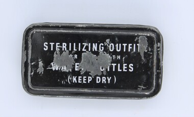
... This enabled the Digger to drink his water in the surity that he would not pick up a problem from contaminated water that may have been his only liquid available. ...Normal WW2 and Korian War period, normal for this period and contains the bottles of sterilization tabletsThe Diggers Water Bottle had to be completly emptied then refilled with the water available, then the tablets added according to the instructions inside the lid. This enabled the Digger to drink his water in the surity that he would not pick up a problem from contaminated water that may have been his only liquid available. These tablets have been produced by science to keep the diggers in top fighting condition. Not rare but everybody both male and female (Nurses etc.) would be issued with this tin of tablets.7 by 3.5 by 2.5 mm tin. The lid is 2.5 mm deep painted black with white writing which says, STERILIZING OUTFIT FOR USE WITH WATER BOTTLES (Keep Dry)As Abovesterilizing outfit., ww2, new guinea, korian war, borneo, boganville etc., etc -
 Shepparton RSL Sub Branch
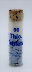
Bottle-Tablet. 50 Thio. Tablets, Bottle, Period. WW2
... This enabled the Digger to drink his water in the surity that he would not pick up a problem from the contaminated water that may have been his only liquid available. ...Normal WW2 and Korian War period, normal for this period bottle contains Thio. Tablets.The Diggers Water Bottle had to be completly emptied then refilled with the water available, then the tablets added after crushing according to the instructions inside the lid. This enabled the Digger to drink his water in the surity that he would not pick up a problem from the contaminated water that may have been his only liquid available. These tablets have been produced by science to keep the diggers in top fighting condition. Not rare but everybody both male and female (Nurses etc.) would be issued with this tin of tablets.60 X 18 mm glass bottle with cork 11 X 17 mm and cotton wool, contains 50 blue Thio tabletsMarked on bottle in blue paint, 50. Thio. Tablets. Drug Houses of Australia Ltd. Australia. bottle from sterilizing outfit outfit. contains blue tablets, ww2, new guinea, korian war, borneo, boganville etc., etc -
 Shepparton RSL Sub Branch
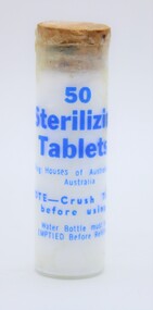
Bottle-Tablet. 50 Thio. Tablets, Bottle, Period. WW2
... This enabled the Digger to drink his water in the surity that he would not pick up a problem from the contaminated water that may have been his only liquid available. ...Normal WW2 and Korian War period, normal for this period bottle contains Sterilization Tablets.The Diggers Water Bottle had to be completly emptied then refilled with the water available, then the tablets added after crushing according to the instructions inside the lid. This enabled the Digger to drink his water in the surity that he would not pick up a problem from the contaminated water that may have been his only liquid available. These tablets have been produced by science to keep the diggers in top fighting condition. Not rare but everybody both male and female (Nurses etc.) would be issued with this tin of tablets.60 X 18 mm glass bottle with cork 11 X 17 mm and cotton wool, contains 50 White Sterilization tabletsMarked on bottle in blue paint, 50. Sterilization. Tablets. Drug Houses of Australia Ltd. Australia. ww2, new guinea, korian war, borneo, boganville etc., etc, bottle contains 50 white sterilization tablets -
 Eltham District Historical Society Inc
Film - Video (VHS), Nillumbik Shire Council, The Nillumbik Story, 1996
... problem. Having previously planted Cypress rows they are replacing them with indigenous species to improve the water supply, keeping cattle out of the creek bed to improve the quality downstream flowing into the Yarra. ...problem. Having previously planted Cypress rows they are replacing them with indigenous species to improve the water supply, keeping cattle out of the creek bed to improve the quality downstream flowing into the Yarra. ...PART 1 – NILLUMBIK (00:00-07:17) Opening features various scenes around Nillumbik Shire. For 40,000 years Nillumbik was the home of the Wurundjeri people. Robert Hoddle gave the district its name. Jock Ryan, then president of Nillumbik Historical Society discusses the names Nillumbik and Diamond Creek. In the late 1830s white occupation began with gold found in Warrandyte in 1851 and 12 years later at Diamond Creek -the Diamond Reef which led to the Caledonian gold rush. Jock Ryan discusses the Diamond Creek mine, which was thriving until it burnt out in 1915. Large numbers of workmen moved into area in late 1870s to construct the Maroondah Aqueduct. With growing population of Melbourne, the nearby Yan Yean system had severely disrupted the flow of the Plenty River, forcing the closure of three flour mills there. The aqueduct came to the rescue carrying water 66km from Healesville to Preston. When the Diamond Creek gold mine burnt down the local economy suffered but fruit growing industry had already been established and Diamond Creek became a thriving fruit growing centre. Interview with Jack Powell, a long-time fruiterer at St Andrews market, his family had lived in the area for a hundred years, 3 to 4 generations, “a lot of hard work”. By the time the railway arrived fruit growing was no longer competitive. The railway brought the city closer and day trippers. The Green Wedge separates the shire from the more densely developed neighbours such as Whittlesea, Doncaster, Templestowe, Bulleen and Greensborough. Population at the time (1996) was 19,000 but links to the past remain strong. Mudbrick houses along the Heritage Trail The saving of Shillinglaw Cottage from demolition in 1963 and relocation brick by brick. PART 2 – ENVIRONMENT (07:18-14:44) Peter Brock (with Bev Brock in background) at St Andrews market discusses his childhood growing up in the district and the environment and the values it instilled upon him and his own family. The Brocks have been in the district since the 1860s. Nillumbik Shire responsible for managing three catchment areas; Diamond Creek, Arthurs Creek and Watsons Creek. Follows the course of the Diamond Creek commencing in Kinglake through the district to its confluence with the Yarra River at Eltham at Eltham Lower Park. Highlights Eltham Lower Park community revegetation program and the newly constructed (1996) viewing platform built of new and recycled timbers at the confluence of the Diamond Creek and Yarra River. Also featured are outdoor recreation on the river and at Eltham Lower Park including the Diamond Valley miniature railway. Sugarloaf reservoir and recreational activities and fishing. Aerial view of Memorial Park and Shire of Eltham War Memorial tower at Garden Hill, Kangaroo Ground. Significant tourism opportunities for the shire with 3 million potential day-trippers in metropolitan Melbourne. Council and community working together to find a way to promote the shires natural and artistic assets. At Arthurs Creek, the Brock family and neighbours working together to take care of their waterway. Peter Brock’s uncle, Sandy Brock talks about environmental management and the Arthurs Creek Landcare group and actions to eradicate blackberry problem. Having previously planted Cypress rows they are replacing them with indigenous species to improve the water supply, keeping cattle out of the creek bed to improve the quality downstream flowing into the Yarra. Eltham East Primary School Band playing “All things bright and beautiful” merges into scenes of the bushland sanctuary set aside by the school in 1980 with unidentified teacher discusses the sanctuary and their education program and school children’s comments. Plight of a family of Wedgetail eagles nesting in the path of a developer’s bulldozer at North Warrandyte and actions to save their nesting areas. PART 3 – ARTS (14:45-22:00) Arts and Jazz festival at Montsalvat featuring interviews with Sigmund Jorgensen discussing Montsalvat and its principles. Also Matcham Skipper. Clifton Pugh’s funeral at Montsalvat and his legacy at Dunmoochin near Cottlesbridge with artists in residence, at the time, Chicago artist Charles Reddington who discusses the benefits of the experience. An unidentified female artist also talks about the program and why people are drawn to the area. Unidentified man on street talking about the amount of talent in the area, artists, poets, musicians, authors. Artist Ming Mackay (1918-2009) interviewed talking about the people she mixes with on “the Hill”. Works of local artists are displayed Eltham Library Community Gallery and Wiregrass gallery with a new coffee shop at the Wiregrass making it an even more popular destination. Music at St Andrews Hotel (may be a little bit country) and the Saturday market where likely to hear anything. Sellers and patrons at the market asked about what attracts them to the market and where they came from. Scenes of poets/authors giving readings. CREDITS Music by John Greenfield from the CD Sweet Rain “The Snow Tree”, Uncle Music UNC 2001 Cameras - David Mirabella and Peter Farragher Editor – Olwyn Jones Written and Produced by Jason Cameron A Jason Cameron Proction for Nillumbik ShireProvides a record of the relatively newly created Shire of Nillumbik at the time and the features and attactions of the shire in its people arts, culture and environmentVHS Cassette (five copies) DVD (one copy) Converted to MP4 file format 0:22:00, 1.60GBvideo recording, arthurs creek, arthurs creek landcare group, artists, artists in residence, arts, arts festival, authors, blackberry, brock family, bulldozer, bulleen, bushland sanctuary, caledonian gold rush, charles reddington, clifton pugh, cottlesbridge, cypress rows, developer, diamond creek, diamond creek mine, diamond reef, diamond valley miniature railway, doncaster, dunmoochin, education program, eeps, eltham, eltham east primary school, eltham east primary school band, eltham library community gallery, eltham lower park, environment, fishing, flour mill, fruit growing, fruiterer, garden hill, gold mining, green wedge, greensborough, heritage trail, hurstbridge railway line, jazz festival, jock ryan, kangaroo ground, kangaroo ground tower, kinglake, maroondah aqueduct, matcham skipper, memorial park, ming mackay (1918-2009), montsalvat, mudbrick houses, music, musicians, nesting area, nillumbik historical society, nillumbik shire, north warrandyte, old timer, orchards, peter brock, plenty river, poets, population, recreation, recreational activities, revegetation, robert hoddle, sandy brock, shillinglaw cottage, shire of eltham war memorial, sigmund jorgensen, st andrews hotel, st andrews market, sugarloaf reservoir, templestowe, the hill, tourism, viewing platform, warrandyte, water catchment area, watsons creek, wedgetail eagle, whittlesea, wiregrass gallery, wurundjeri, yarra river, jack powell -
 Eltham District Historical Society Inc
Film - Video (DVD), Melbourne and Metropolitan Board of Works, Yarra River Conference Proceedings; a Board of Works centenary event, 13-16 April 1991
... problems have had on the Yarra during a century and a half of European occupation. As no formal written paper of this combined presentation is available, these two video-tapes provide a record for anyone who has an interest in tis fascinating aspect of the Yarra's history. The speakers who combined to present this segment are identified on the cover of Tape 2. Tape 1 (2 hours) 1838-1863 Deputy ?? to Utility Early navigators of the Yarra River; developing the port of Melbourne; the gold rush and its effect on the new colony; punts and bridges; water...problems have had on the Yarra during a century and a half of European occupation. As no formal written paper of this combined presentation is available, these two video-tapes provide a record for anyone who has an interest in tis fascinating aspect of the Yarra's history. The speakers who combined to present this segment are identified on the cover of Tape 2. Tape 1 (2 hours) 1838-1863 Deputy ?? to Utility Early navigators of the Yarra River; developing the port of Melbourne; the gold rush and its effect on the new colony; punts and bridges; water ...Yarra River Conference History Segment [Noted on VHS tape jackets "Due to unavoidable circumstances, the quality of these tapes in some setions is less than desired."] The Yarra River Conference, organised by the Board of Works as part of the Centenary Celebrations, was held in the Board's Head Office Theatrette from 13-16 April, 1991. A segment of the Conference focussed on the role that the Yarra River has played in relation to the historical development of Melbourne. Conceived and presented by a group of prominent historians as a chronological 'trip down the river in time', and profusely illustrated with slides, this segment traced the various impacts that urban and rural growth, development of marine commerce, recreational uses, and environmental problems have had on the Yarra during a century and a half of European occupation. As no formal written paper of this combined presentation is available, these two video-tapes provide a record for anyone who has an interest in tis fascinating aspect of the Yarra's history. The speakers who combined to present this segment are identified on the cover of Tape 2. Tape 1 (2 hours) 1838-1863 Deputy ?? to Utility Early navigators of the Yarra River; developing the port of Melbourne; the gold rush and its effect on the new colony; punts and bridges; water supply; pollution of the Yarra; the discovery of gold and early settlement of the Yarra valley; floods of 1839 and 1863. 1863-1891 Formation of the Harbour Trust; Coode Canal; pollution of the Yarra by industry; aborigines, gold miners, timber getters in the Upper Yarra areas; bridges; the flood of 1891. Tape 2 ( 1 1/2 hours) 1892-1934: People Begin to See Beauty and Romance to the River Henley-on-Yarra; realignment of the Yarra; MMBW is responsible for a sewerage system; new docks to cope with increased overseas trade; development of recreational parks; new reservoirs; timber production and timber tramways; bushfire; flood of 1934. 1935-1970: The River is Neglected Still, Except When it Proves Useful Bushfirs of 1939; the end of many sawmills; birth of tourism; increased interest in conservation and preservation of land for open space; further augmentation of water supply system; birth of containerisation changes the port; environmental concerns gain momentum. Speakers Dr Tony Dingle *, Department of Economic History, Monash University Dr Carolyn Rasmussen *, History Consultant Prof. Graeme Davison, History Department, Monash University Mr. Tom Griffiths, Lecturer in Public History, Monash Uiversity Mr. Patrick Miller, History Consultant Mr. Colin Jones, Author and Historian * Co-authors of the Board's history, 'Vital Connections'.video recording, yarra river, conference proceedings -
 Eltham District Historical Society Inc
Photograph - Digital Photograph, Alan King, Site of the Diamond Creek Gold Mine, 28 December 2007
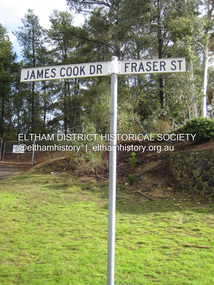
... problems. When the local dam dried up a Blake pump was installed to draw water from the creek. ...problems. When the local dam dried up a Blake pump was installed to draw water from the creek. ...The largest gold mine in the area originated from a find in 1862. The mine was closed January 20, 1915 when a fire destroyed nearly all the above ground plant. Published: Nillumbik Now and Then / Marguerite Marshall 2008; photographs Alan King with Marguerite Marshall.; p75 Beneath Mine Hill, as locals call it, runs a network of tunnels once of central importance to the fledgling township of Diamond Creek. These are relics of gold mines, which transformed early Diamond Creek.1 The tiny settlement of about 20 families soared to more than 200 because of gold. For around 50 years, from 1862, gold mining was Diamond Creek’s major source of employment. On September 7, 1854 The Argus newspaper reported a find of a four pound (1.8kg) gold nugget in Nillumbik (an early name for Diamond Creek). Exactly where, is not known.2 The largest mine in the district, the Diamond Creek Gold Mine, apparently originated from a find in 1862. It is said Joe and Dave Wilson were visiting former tailor then cook, Charles Orme, at the southern end of Fraser Street. Sitting on a stump outside the front gate on land belonging to Dr A. E. Phipps the Wilsons found a vein of gold-bearing quartz, which led to the discovery of four quartz reefs varying in width to eight inches (20cm), running north and south. A reef found at the foot of the hill opposite Challenger Street became the Union Mine. This reef was traced south to Allendale Road where a small mine began operations.3 Other smaller mines later operated as well. Dr Phipps immediately began to mine and also built the Diamond Reef Hotel as a boarding house for miners. But Charles Orme, who owned the land alongside, leased his mine to Dr Phipps probably because of insufficient funds and business skills. By mid 1865 the mine had produced 2530 ounces of gold – a 100% profit on the original outlay. Of course there were problems. When the local dam dried up a Blake pump was installed to draw water from the creek. The Union Mine operated under the Diamond Creek Gold Mine management except when disputes sometimes resulted in separate management. However disagreements had to be resolved as the Union Mine depended on Diamond Creek Gold Mine pumps to remove underground water from common reefs. In 1912 the main shaft of about 380 yards (350m) employed 200 men recovering an average of 5000 ounces (141.7kg) of gold a year. But not everyone did well out of gold. Records of failed mining companies in the Victorian Public Record Office, reveal that owner Dr Phipps leased his Right to others. Companies came and went over the next 40 years, most sponsored by Melbourne businessmen who sold shares to gullible locals and then became insolvent. Although there were some good profits, financial returns were haphazard until 1905. Some local residents, who were share holders in short- term companies, became well-known names in modern Diamond Creek such as Scott, Haley, Butler, Alder, Ryan, Wadeson, Reeves, Alston, Paul and Edwards. Gold mining was brought to a disastrous end on January 20, 1915 at 3 pm, when fire destroyed nearly all the above-ground plant. Fortunately no lives were lost. But reopening the mine was almost impossible because of the increasing depth of water in the main shaft. The closed mine destroyed the livelihood of 200 families and the debris took many years to clear.4 In 1946 the Diamond Creek Gold Mine was reopened by the Golden Hind Mining Company, but money ran out before the 600 feet (182.8m) or so of water could be removed. Gold remains in the mine but enormous capital would be needed to buy the land, equipment and to remove the water. Today 12 known sealed shafts along the ridge of the hills on private property extend west for around one kilometre from the corner of Fraser and Haley Streets, crossing Norma and Fyffe to Dering Streets. As recently as 1987, heavy rains revealed a former Union Mine shaft in the Georgiadis family Fyffe Street back yard.5 Allendale Mine, south of Allendale Road, is still open and one of the Union Mine’s main drives (horizontal excavation) remains unsealed, on the Creek Reserve.This collection of almost 130 photos about places and people within the Shire of Nillumbik, an urban and rural municipality in Melbourne's north, contributes to an understanding of the history of the Shire. Published in 2008 immediately prior to the Black Saturday bushfires of February 7, 2009, it documents sites that were impacted, and in some cases destroyed by the fires. It includes photographs taken especially for the publication, creating a unique time capsule representing the Shire in the early 21st century. It remains the most recent comprehenesive publication devoted to the Shire's history connecting local residents to the past. nillumbik now and then (marshall-king) collection, diamond creek, diamond creek mine, fraser street, gold mining, james cook drive, mine hill -
 Bendigo Historical Society Inc.
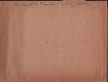
Document - MCCOLL, RANKIN AND STANISTREET COLLECTION: CENTRAL NELL GWYNNE - SPECIAL RECORDS FILE, 21/12/42 - 24/12/42
... Document. 1 manila folder containing 5 letters including drafts pertaining to a lack of manpower in the mine & the problems this leads to in baling the water in the mine. Also included is a list of details of 52 pounds & 8 shillings cost per week to keep Central Nell Gwynne Mine unwatered. ...History House 11 Mackenzie Street Bendigo goldfields ORGANIZATION Business central nell gwynne McColl Rankin & Stanistreet Central Nell Gwynne GMC gold mining letters McColl, Rankin & Stanistreet Document. 1 manila folder containing 5 letters including drafts pertaining to a lack of manpower in the mine & the problems this leads to in baling the water in the mine. Also included is a list of details of 52 pounds & 8 shillings cost per week to keep Central Nell Gwynne Mine unwatered. ...Document. 1 manila folder containing 5 letters including drafts pertaining to a lack of manpower in the mine & the problems this leads to in baling the water in the mine. Also included is a list of details of 52 pounds & 8 shillings cost per week to keep Central Nell Gwynne Mine unwatered. Also a list of reasons for keeping the shaft & workings free of water.McColl, Rankin & Stanistreetorganization, business, central nell gwynne, mccoll, rankin & stanistreet, central nell gwynne gmc, gold mining, letters -
 Bendigo Historical Society Inc.
Book - AILEEN AND JOHN ELLISON COLLECTION: THREE DECADES
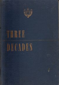
... Chapter 2: The commission is born - Chapter 3: Electricity from Yallourn coal - Chapter 4: Water power and growth to 1939 - Chapter 5: The war years and Kiewa - Chapter 6: Post war problems and rationing - Chapter 7: the spirit of Yallourn - Chapter 8: looking ahead organisation and finance - Chapter 9: Briquettes from Yallourn coal - Chapter 10: Transport, workshops, stores, purchasing - Chapter 11: The human side - Chapter 12: From power system to consumer - Chapter 13: Research, communications, regulations - Epilogue...Chapter 2: The commission is born - Chapter 3: Electricity from Yallourn coal - Chapter 4: Water power and growth to 1939 - Chapter 5: The war years and Kiewa - Chapter 6: Post war problems and rationing - Chapter 7: the spirit of Yallourn - Chapter 8: looking ahead organisation and finance - Chapter 9: Briquettes from Yallourn coal - Chapter 10: Transport, workshops, stores, purchasing - Chapter 11: The human side - Chapter 12: From power system to consumer - Chapter 13: Research, communications, regulations - Epilogue Book AILEEN AND JOHN ELLISON COLLECTION: THREE DECADES ...Book titled "Three Decades" Blue cover with gold lettering. On the front the emblem of the State Electricity Commission of Victoria 1921. The book has 192 pages. Three Decades - the story of the State Electricity commission of Victoria from its inception to December 1948. With a Foreword by The Hon. T. T. Hollway, Premier of Victoria. with 150 illustrations published by Hutchinson & Co. Ltd. First published March, 1949. Contents: Foreword - Chapter 1: The stage is set. Chapter 2: The commission is born - Chapter 3: Electricity from Yallourn coal - Chapter 4: Water power and growth to 1939 - Chapter 5: The war years and Kiewa - Chapter 6: Post war problems and rationing - Chapter 7: the spirit of Yallourn - Chapter 8: looking ahead organisation and finance - Chapter 9: Briquettes from Yallourn coal - Chapter 10: Transport, workshops, stores, purchasing - Chapter 11: The human side - Chapter 12: From power system to consumer - Chapter 13: Research, communications, regulations - Epiloguebooks, technical, electrical -
 Mission to Seafarers Victoria
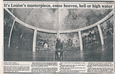
Article - Clipping, photocopy, Sarah Turner, It’s Louise’s masterpiece, come heaven, hell or high water, 1988
... Sadly though, Hearman said the mural was likely to fall off the walls and domed ceiling unless the room was waterproofed - water damage is a serious problem at the mission. ...Sadly though, Hearman said the mural was likely to fall off the walls and domed ceiling unless the room was waterproofed - water damage is a serious problem at the mission. Black and white copy of a newspaper article, printed on A3 paper. ...Louise Hearman used the Norla Dome and painted a mural painted which had taken her around a year to complete. The exhibition called Elephant Room was shown from June 1988. The work was vandalised in 1989 and subsequently demolished.Louise Hearman is a Melbourne born artist and Archibald Prize winner. Hearman first came to public notice in 1987/88 when she spent a year painting the mural in the Norla Dome. The premises of the Mission also served as her studio at that time.Black and white copy of a newspaper article, printed on A3 paper.It’s Louise’s masterpiece, come heaven, hell or high water Report: SARAH TURNER PICTURE: LEIGH HENNINGHAM When her Little Bourke St studio was pulled down to make way for a carpark, artist Louise Hearman, above, contacted The Seamen’s Mission in Flinders St to see whether she could use their cottage. They agree. But neither knew what it was going to lead to. When Hearman saw ‘the Elephant Room’ at the mission, a big domed room, she felt she “just had to do something with it”. She applied for and was granted a $3250 grant from the Australia Council, with which she was able to buy the necessary scaffold and paint, and then set about transforming the room. Now, a year later, her masterpiece is complete. Hearman emphasised the the mural doesn’t represent “heaven and hell”. Rather, she said, “people should make their own interpretations”. She said it was “not particularly heaven and hell, it’s not particularly anything”. And there is “no narrative” to the mural. It “just developed with the building”, out of whatever images and feeling Hearman had at the time. Sadly though, Hearman said the mural was likely to fall off the walls and domed ceiling unless the room was waterproofed - water damage is a serious problem at the mission. louise hearman, norla dome, exhibitions, 1988, elephant room, flinders street, melbourne, leigh henningham, cultural events