Showing 79 items matching "1086"
-
 National Vietnam Veterans Museum (NVVM)
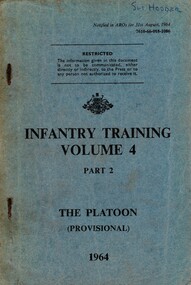
Booklet, Australian Army, Australian Army: Infantry Training, Volume 4, Part 2: The Platoon (Provisional) 1964 (Copy 1), 1964
... Top right hand corner reads Sgt Hodden and under this 7610-66-018-1086. Uner the Australian Coat of Arms are the details of the booklet, There are two rusty metal staples down the left hand side....Top right hand corner reads Sgt Hodden and under this 7610-66-018-1086. Uner the Australian Coat of Arms are the details of the booklet, There are two rusty metal staples down the left hand side. ...A grey/blue cardboard cover with black information on the cover. Top right hand corner reads Sgt Hodden and under this 7610-66-018-1086. Uner the Australian Coat of Arms are the details of the booklet, There are two rusty metal staples down the left hand side.booklet, australian army, infantry training, the platoon -
 Ballarat Heritage Services
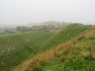
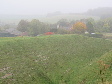
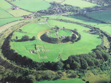
Photograph - Colour, Earth Banks, Old Sarum, England, 2016, 01 November 2016
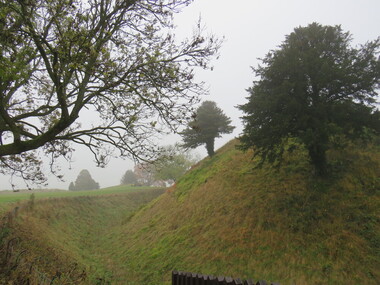
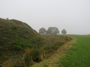
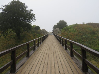
... ...1086...It was here in 1070 that William paid off his army after a long and bitter campaign in northern England. It was here in 1086 that he called together all the major landholders in England so they could swear allegiance to him. ...It was here in 1070 that William paid off his army after a long and bitter campaign in northern England. It was here in 1086 that he called together all the major landholders in England so they could swear allegiance to him. ...William the Conqueror inherited Old Sarum from the last Saxon king of England. It was an ideal site for a royal castle. It was here in 1070 that William paid off his army after a long and bitter campaign in northern England. It was here in 1086 that he called together all the major landholders in England so they could swear allegiance to him. It was a crucial moment. The Domesday Book was being written, a threatened Viking invasion had only just been averted and William's eldest son was in armed rebellion. Old Sarum was an important place where this Norman king of England held power. In 1794 the Ordnance Survey set out to check the accuracy of the first mapping of Southern England, which had begun ten years earlier. From a point just below Old Sarum Lieutenant William Mudge laid out a base-line 36,574 feet (11,253 metres) long. From each end of the line the positions of distant places were plotted using a huge theodolite made in 1791 by Jesse Ramsden. The accuracy of the process, which was repeated all over England, depended on Jesse Ramsden's craftsmanship and on William Mudge's surveying skill in setting out this first base-line from Old Sarum. The nearer end of Mudge's line is marked by an inscribed stone beside the modern A345 at Old Sarum. ordnance survey, william mudge, jesse ramsden, william the conqueror, old sarum, saxon, 1086, england -
 Ballarat Heritage Services
Photograph - Photograph - Colour, Earth Banks, Old Sarum, England, 01 November 2016
... ...1086...It was here in 1070 that William paid off his army after a long and bitter campaign in northern England. It was here in 1086 that he called together all the major landholders in England so they could swear allegiance to him. ...It was here in 1070 that William paid off his army after a long and bitter campaign in northern England. It was here in 1086 that he called together all the major landholders in England so they could swear allegiance to him. ...William the Conqueror inherited Old Sarum from the last Saxon king of England. It was an ideal site for a royal castle. It was here in 1070 that William paid off his army after a long and bitter campaign in northern England. It was here in 1086 that he called together all the major landholders in England so they could swear allegiance to him. It was a crucial moment. The Domesday Book was being written, a threatened Viking invasion had only just been averted and William's eldest son was in armed rebellion. Old Sarum was an important place where this Norman king of England held power. In 1794 the Ordnance Survey set out to check the accuracy of the first mapping of Southern England, which had begun ten years earlier. From a point just below Old Sarum Lieutenant William Mudge laid out a base-line 36,574 feet (11,253 metres) long. From each end of the line the positions of distant places were plotted using a huge theodolite made in 1791 by Jesse Ramsden. The accuracy of the process, which was repeated all over England, depended on Jesse Ramsden's craftsmanship and on William Mudge's surveying skill in setting out this first base-line from Old Sarum. The nearer end of Mudge's line is marked by an inscribed stone beside the modern A345 at Old Sarum. Colour photograph of Earth Banks, Old Sarum, Englandordnance survey, william mudge, jesse ramsden, william the conqueror, old sarum, saxon, 1086, england -
 Ballarat Heritage Services
Photograph - Colour, Earth Banks, Old Sarum, England, 01 November 2016
... ...1086...It was here in 1070 that William paid off his army after a long and bitter campaign in northern England. It was here in 1086 that he called together all the major landholders in England so they could swear allegiance to him. ...It was here in 1070 that William paid off his army after a long and bitter campaign in northern England. It was here in 1086 that he called together all the major landholders in England so they could swear allegiance to him. ...William the Conqueror inherited Old Sarum from the last Saxon king of England. It was an ideal site for a royal castle. It was here in 1070 that William paid off his army after a long and bitter campaign in northern England. It was here in 1086 that he called together all the major landholders in England so they could swear allegiance to him. It was a crucial moment. The Domesday Book was being written, a threatened Viking invasion had only just been averted and William's eldest son was in armed rebellion. Old Sarum was an important place where this Norman king of England held power. In 1794 the Ordnance Survey set out to check the accuracy of the first mapping of Southern England, which had begun ten years earlier. From a point just below Old Sarum Lieutenant William Mudge laid out a base-line 36,574 feet (11,253 metres) long. From each end of the line the positions of distant places were plotted using a huge theodolite made in 1791 by Jesse Ramsden. The accuracy of the process, which was repeated all over England, depended on Jesse Ramsden's craftsmanship and on William Mudge's surveying skill in setting out this first base-line from Old Sarum. The nearer end of Mudge's line is marked by an inscribed stone beside the modern A345 at Old Sarum. ordnance survey, william mudge, jesse ramsden, william the conqueror, old sarum, saxon, 1086, england -
 Ballarat Heritage Services
Photograph - Colour, Earth Banks, Old Sarum, England, 2016, 01 November 2016
... ...1086...It was here in 1070 that William paid off his army after a long and bitter campaign in northern England. It was here in 1086 that he called together all the major landholders in England so they could swear allegiance to him. ...It was here in 1070 that William paid off his army after a long and bitter campaign in northern England. It was here in 1086 that he called together all the major landholders in England so they could swear allegiance to him. ...William the Conqueror inherited Old Sarum from the last Saxon king of England. It was an ideal site for a royal castle. It was here in 1070 that William paid off his army after a long and bitter campaign in northern England. It was here in 1086 that he called together all the major landholders in England so they could swear allegiance to him. It was a crucial moment. The Domesday Book was being written, a threatened Viking invasion had only just been averted and William's eldest son was in armed rebellion. Old Sarum was an important place where this Norman king of England held power. In 1794 the Ordnance Survey set out to check the accuracy of the first mapping of Southern England, which had begun ten years earlier. From a point just below Old Sarum Lieutenant William Mudge laid out a base-line 36,574 feet (11,253 metres) long. From each end of the line the positions of distant places were plotted using a huge theodolite made in 1791 by Jesse Ramsden. The accuracy of the process, which was repeated all over England, depended on Jesse Ramsden's craftsmanship and on William Mudge's surveying skill in setting out this first base-line from Old Sarum. The nearer end of Mudge's line is marked by an inscribed stone beside the modern A345 at Old Sarum. ordnance survey, william mudge, jesse ramsden, william the conqueror, old sarum, saxon, 1086, england -
 Ballarat Heritage Services
Photograph - Colour, Earth Banks, Old Sarum, England, 01 November 2016
... ...1086...It was here in 1070 that William paid off his army after a long and bitter campaign in northern England. It was here in 1086 that he called together all the major landholders in England so they could swear allegiance to him. ...It was here in 1070 that William paid off his army after a long and bitter campaign in northern England. It was here in 1086 that he called together all the major landholders in England so they could swear allegiance to him. ...William the Conqueror inherited Old Sarum from the last Saxon king of England. It was an ideal site for a royal castle. It was here in 1070 that William paid off his army after a long and bitter campaign in northern England. It was here in 1086 that he called together all the major landholders in England so they could swear allegiance to him. It was a crucial moment. The Domesday Book was being written, a threatened Viking invasion had only just been averted and William's eldest son was in armed rebellion. Old Sarum was an important place where this Norman king of England held power. In 1794 the Ordnance Survey set out to check the accuracy of the first mapping of Southern England, which had begun ten years earlier. From a point just below Old Sarum Lieutenant William Mudge laid out a base-line 36,574 feet (11,253 metres) long. From each end of the line the positions of distant places were plotted using a huge theodolite made in 1791 by Jesse Ramsden. The accuracy of the process, which was repeated all over England, depended on Jesse Ramsden's craftsmanship and on William Mudge's surveying skill in setting out this first base-line from Old Sarum. The nearer end of Mudge's line is marked by an inscribed stone beside the modern A345 at Old Sarum. ordnance survey, william mudge, jesse ramsden, william the conqueror, old sarum, saxon, 1086, england -
 Ballarat Heritage Services
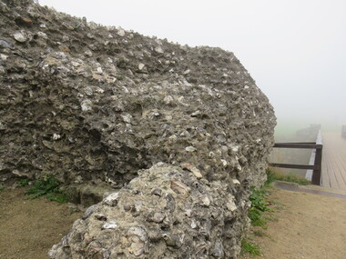
Photograph - Colour, Stonework, Old Sarum, England, English Heritage Site, 01 November 2016
... ...1086...It was here in 1070 that William paid off his army after a long and bitter campaign in northern England. It was here in 1086 that he called together all the major landholders in England so they could swear allegiance to him. ...It was here in 1070 that William paid off his army after a long and bitter campaign in northern England. It was here in 1086 that he called together all the major landholders in England so they could swear allegiance to him. ...William the Conqueror inherited Old Sarum from the last Saxon king of England. It was an ideal site for a royal castle. It was here in 1070 that William paid off his army after a long and bitter campaign in northern England. It was here in 1086 that he called together all the major landholders in England so they could swear allegiance to him. It was a crucial moment. The Domesday Book was being written, a threatened Viking invasion had only just been averted and William's eldest son was in armed rebellion. Old Sarum was an important place where this Norman king of England held power. In 1794 the Ordnance Survey set out to check the accuracy of the first mapping of Southern England, which had begun ten years earlier. From a point just below Old Sarum Lieutenant William Mudge laid out a base-line 36,574 feet (11,253 metres) long. From each end of the line the positions of distant places were plotted using a huge theodolite made in 1791 by Jesse Ramsden. The accuracy of the process, which was repeated all over England, depended on Jesse Ramsden's craftsmanship and on William Mudge's surveying skill in setting out this first base-line from Old Sarum. The nearer end of Mudge's line is marked by an inscribed stone beside the modern A345 at Old Sarum. ordnance survey, william mudge, jesse ramsden, william the conqueror, old sarum, saxon, 1086, england -
 Ballarat Heritage Services
Photograph - Photograph - Colour, Old Sarum, England, 2016, 01/11/2016
... ...1086...It was here in 1070 that William paid off his army after a long and bitter campaign in northern England. It was here in 1086 that he called together all the major landholders in England so they could swear allegiance to him. ...It was here in 1070 that William paid off his army after a long and bitter campaign in northern England. It was here in 1086 that he called together all the major landholders in England so they could swear allegiance to him. ...William the Conqueror inherited Old Sarum from the last Saxon king of England. It was an ideal site for a royal castle. It was here in 1070 that William paid off his army after a long and bitter campaign in northern England. It was here in 1086 that he called together all the major landholders in England so they could swear allegiance to him. It was a crucial moment. The Domesday Book was being written, a threatened Viking invasion had only just been averted and William's eldest son was in armed rebellion. Old Sarum was an important place where this Norman king of England held power. In 1794 the Ordnance Survey set out to check the accuracy of the first mapping of Southern England, which had begun ten years earlier. From a point just below Old Sarum Lieutenant William Mudge laid out a base-line 36,574 feet (11,253 metres) long. From each end of the line the positions of distant places were plotted using a huge theodolite made in 1791 by Jesse Ramsden. The accuracy of the process, which was repeated all over England, depended on Jesse Ramsden's craftsmanship and on William Mudge's surveying skill in setting out this first base-line from Old Sarum. The nearer end of Mudge's line is marked by an inscribed stone beside the modern A345 at Old Sarum. Colour photograph of Old Sarum, England.ordnance survey, william mudge, jesse ramsden, william the conqueror, old sarum, saxon, 1086, england -
 Ballarat Heritage Services
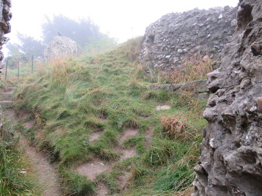
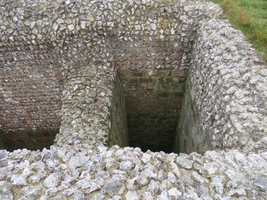
Photograph - Photograph - Colour, Castle toilets, Old Sarum, England, 2016, 01/11/2016
... ...1086...It was here in 1070 that William paid off his army after a long and bitter campaign in northern England. It was here in 1086 that he called together all the major landholders in England so they could swear allegiance to him. ...It was here in 1070 that William paid off his army after a long and bitter campaign in northern England. It was here in 1086 that he called together all the major landholders in England so they could swear allegiance to him. ...William the Conqueror inherited Old Sarum from the last Saxon king of England. It was an ideal site for a royal castle. It was here in 1070 that William paid off his army after a long and bitter campaign in northern England. It was here in 1086 that he called together all the major landholders in England so they could swear allegiance to him. It was a crucial moment. The Domesday Book was being written, a threatened Viking invasion had only just been averted and William's eldest son was in armed rebellion. Old Sarum was an important place where this Norman king of England held power. In 1794 the Ordnance Survey set out to check the accuracy of the first mapping of Southern England, which had begun ten years earlier. From a point just below Old Sarum Lieutenant William Mudge laid out a base-line 36,574 feet (11,253 metres) long. From each end of the line the positions of distant places were plotted using a huge theodolite made in 1791 by Jesse Ramsden. The accuracy of the process, which was repeated all over England, depended on Jesse Ramsden's craftsmanship and on William Mudge's surveying skill in setting out this first base-line from Old Sarum. The nearer end of Mudge's line is marked by an inscribed stone beside the modern A345 at Old Sarum. Colour photographs of Castle toilets at Old Sarum, England. The toilets are constructed of stone. ordnance survey, william mudge, jesse ramsden, william the conqueror, old sarum, saxon, 1086, england, subjects, toilets -
 Federation University Historical Collection
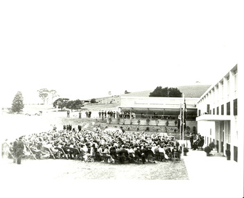
Photograph, Noel L. Harvey & Son, Official Opening of the University of Ballarat Mt Helen Campus, 31/10/1970
... An overview of the development of the Ballarat Institute of advanced Education (BIAE) is given on the program of the official opening of Mt Helen campus (Cat. No. 1086)...An overview of the development of the Ballarat Institute of advanced Education (BIAE) is given on the program of the official opening of Mt Helen campus (Cat. No. 1086) university of ballarat ballarat college of advanced education yendon yendon railway station mb john jack barker nigel bowen rolly perfenovics mount helen campus ballarat brass band bluestone garden .1-3) verso "Tippett" Photographers stamp Black and white photographs showing the opening ceremony for the University of Ballarat Mount Helen Campus. .1) The audience at the opening of the University of Ballarat Mount Helen campus. ...The first building completed at the Mt Helen Campus was "G" Building, and is depicted in this photograph. An overview of the development of the Ballarat Institute of advanced Education (BIAE) is given on the program of the official opening of Mt Helen campus (Cat. No. 1086)Black and white photographs showing the opening ceremony for the University of Ballarat Mount Helen Campus. .1) The audience at the opening of the University of Ballarat Mount Helen campus. The pile of bluestone in the background is most probably bluestone from the Yendon Railway Station. .4) Nigel Bowen, at the microphone stands in front of a new building, with a seated audience in front of him. The bluestone retaining wall was erected from bluestone retrieved from the newly demolished Yendon Railway Station. The Ballarat Brass Band is seated undercover in the background. .6) A number of people seated watching a man give a speech in front of a new building. The man is The Hon. Nigel Bowen, Q.C., M.P., Commonwealth Minister for Education and Science. The building is the first building at the Mt Helen Campus of the University of Ballarat. the bluestone retaining wall used bluestone retrieved after the demolition of the Yendon Railway Station. 26.0 x 26.0 cm.1-3) verso "Tippett" Photographers stampuniversity of ballarat, ballarat college of advanced education, yendon, yendon railway station, mb john, jack barker, nigel bowen, rolly perfenovics, mount helen campus, ballarat brass band, bluestone, garden -
 4th/19th Prince of Wales's Light Horse Regiment Unit History Room
Medals (2), Victory Medal
World War 1 issues2 x miniature Victory Medals with ribbons, one with MID oak leaf.medals, victory medal -
 Bendigo Military Museum
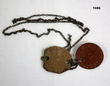
Accessory - IDENTITY DISCS & CHAINSET
Harry Atkin VX21935 2nd AIF. Refer 1079P for his service history.Identity Discs, fibre, one brown, round shape, one light brown 8 sided joined together by a chain re H. Atkin. “H Atkin VX21935 CE” identity, disc’s, atkin -
 Lara RSL Sub Branch
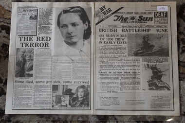
Newspaper - The Sun Newspaper Dated 16/10/1939 - My War Part 3, Local Newspaper - Special My War Part 3 - British Battleship Sunk
Local Newspaper Special re World War 2Newspaper reports of early moves of World War TwoThe Sun Newspaper - My War Part 3 = SPECIAL British Battleship Sunk by German Submarine and other War referencesbritish battleship sunk - poland articales etc. -
Eltham District Historical Society Inc
Folder, John Blyth, 1879
Folder of information on John Blyth, Watsons Creek, 1879john blyth -
 Running Rabbits Military Museum operated by the Upwey Belgrave RSL Sub Branch
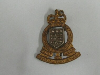
Hat Badge
Hat Badge RAAOC (Ordanance) Now on Hat H172badge/buttons, army -
 Bendigo Historical Society Inc.
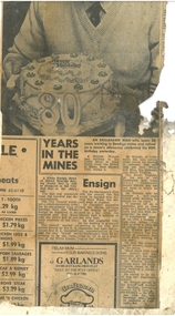
Newspaper - PURDY COLLECTION: WILFRED WATSON ARTICLE
Newspaper article: 'Years in the Mines". Article details the life of an Eaglehawk man who spent 22 years working in Bendigo mines and who is celebrating his 80th birthday (no date on article) Wilfred worked at the Unity Mine in Long Gully, when the Prince of Wales, visited it. He also worked at the Red White and Blue, Big Deborah and South Virginia (between 1920 and 1942) He stated worked as a shoveler and then learnt to bore holes and fire with explosives. At the South Virginia, there were three shifts working the shaft. Each shaft shift had two miners and one shoveller and the mine has 20 or 30 workers.bendigo, mining, wilfred watson -
 Port Melbourne Historical & Preservation Society
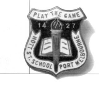
Badge - Nott Street School, Port Melbourne, Stokes & Sons, 1940s
Badge from Nott Street School c1940-41. Shield in deep blue with white scroll areas reading 'Play the Game' 'Nott St School Port Melbourne'; plus gold torch/red flame and open book. '1427' in goldInitials scratched on back, 'JM'education - primary schools, leslie timms, nott street state school -
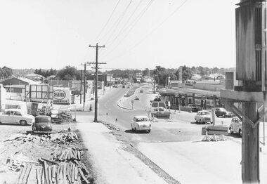 Ringwood and District Historical Society
Photograph, Maroondah Highway West, Ringwood- 1960
Black and white photographWritten on back of photograph: "Maroondah Highway from cool store site - looking west, 1960". -
Glenelg Shire Council Cultural Collection
Book - Book - Victorian Government Gazette 2. 1914, 1 May - 31 August, Victorian Government Gazette 2. 1914, 1 May - 31 August, 1914
Dark green grained fabric over hard cardboard, red leather corners and spine. Spine missing. -
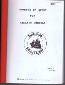 Greensborough Historical Society
Book, James Cook Primary School, Courses of study for Primary Schools / compiled by David Jones, 1978_
A detailed look at a proposed curriculum for all grades at primary school level.An historical record of primary curriculum from the 1970s.Soft red cover, various pagings.james cook primary school, primary curriculum, primary education -
 Ballarat Tramway Museum
Newspaper, The Age, "Where have all the old trams gone?", 30/05/1970 12:00:00 AM
Newspaper clipping from The Age, Saturday Magazine of 30/5/1970 about old tramcars, where they have gone, TMSV, Bylands and Bob Prentice. Has four photographs. Notes that the trams are earmarked for the TMSV's collection, has leased land south of Kilmore and negotiating for a building at Bylands. 1086i1 - ex St. Kilda Railway - Brighton Beach VR 3 at Yarrambat 1086i2 - X1 and X2 at Wantirna 1086i3 - Barry George driver at Glen Huntly showing Peter Stoneham controls of a tram 1086i4 - X1 217 at Malvern Depot Story by Michael Hudson, Pictures Neil Town.In red ink about the X1 X2 photo "30/5/70".trams, tramways, tmsv, tramcar preservation, bylands, mr. r. prentice -
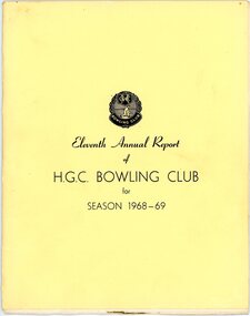 Heidelberg Golf Club
Booklet - Annual Report, Heidelberg Golf Club Bowling Club, Heidelberg Golf Club Bowling Club: Eleventh Annual Report of H.G.C. Bowling Club for season 1968-69, 23/04/1969
Heidelberg Golf Club Bowling Club: Eleventh Annual Report of H.G.C. Bowling Club for season 1968-69. The Bowling Club was formed in 1958 to enable members no longer able to walk the hills of the golf course to have a sporting involvement with the club.Annual reports found in this collection begin in 1959-60. Numbering of Annual Reports begins with the Eighth report in 1965-66.7 page booklet, typed and copied report in printed manilla cover. annual reports, financial reports, heidelberg golf club bowling club -
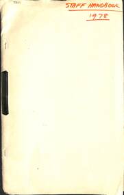 Sunshine and District Historical Society Incorporated
Administrative record - Sunshine Technical School Staff Handbook 1978, 1978
sunshine technical school, technical school, sunshine, staff -
 National Vietnam Veterans Museum (NVVM)
Book, Caputo, Philip, A Rumor of War. (Copy 2)
Philip Caputo was in Vietnam as a young marine for sixteen months. He returned there ten years later, as a correspondent for the Chicago Tribune, to cover the final offensive of that war.Philip Caputo was in Vietnam as a young marine for sixteen months. He returned there ten years later, as a correspondent for the Chicago Tribune, to cover the final offensive of that war. united states. marine corps - biography, vietnam war, 1961-1975 - personal narratives, american -
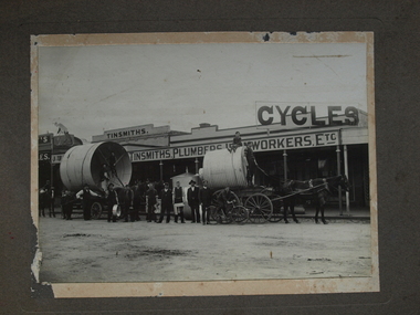 Clunes Museum
Photograph, HORNBY - CLUNES
J. WEICHARDT TINSMITH, PLUMBER, IRONWORKERS AND CYCLES. TWO WATER TANKS LOADED ON HORSE DRAWN WAGONS WITH EMPLOYER EMPLOYEES AND ONLOOKERS.ORIGINAL BLACK AND WHITE PHOTOGRAPH MOUNTED ON CARDBOARD OF THE BUSINESS SECTION FRASER STREET CLUNES - J. WEICKHARDT - TINSMITH, IRON WORKERS AND CYCLES. TWO WATER TANKS LOADED ON HORSE DRAWN WAGONS WITH EMPLOYEES AND ONLOOKERS.HORNBY CLUNESshops, j. weickhardt, tinsmith, plumber, iron workers and cycles., buildings -
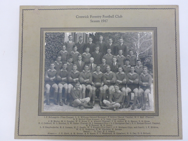 Creswick Campus Historical Collection - University of Melbourne
Photograph - Photograph of the Creswick Forestry Football club . Season 1949, Creswick Forestry Football club . Season 1949, 1947
Creswick Forestry Football ClubPhotograph (Mounted)Creswick Forestry Football Club. Season 1949, includes names of persons in photograph. -
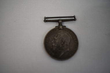 Dandenong/Cranbourne RSL Sub Branch
Medal - British War Medal, WWI 1914 - 1920. No ribbon
Pte. Izzie Shinberg served with several units in France during WW1, the 29th Battalion, the 66th Battalion and the 58th among others.Circular Medal (No ribbon).Obverse shows a central effigy of King George the 5th. Reverse depicts an image of St. George on horseback trampling underfoot the eagle shield of the Central Powers, and a skull and crossbones, the emblems of death. Above this is the risen sun of victory. The years of 1914 and 1918 are contained on the outer edge of the medal. Service # 2139 PTE. I. SHINBERG. 29 BN. A.I.F. are stamped on the medal rim. -
 Wangaratta High School
WHS Yearbook, 1993
A white yearbook with a full page collage in the cover of a number of students artworks and exhibits, with white writing reading WANGARATTA HIGH SCHOOL 1993WANGARATTA HIGH SCHOOL 1993 -
 Stawell Historical Society Inc
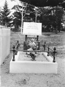
Photograph, Mr Thomas Paice & Mrs Mary Paice nee Unknown's Headstone at the Stawell Cemetery
Grave at Stawell Cemetery Thomas & Mary Paicestawell