Showing 34 items matching "1749"
-
 National Wool Museum
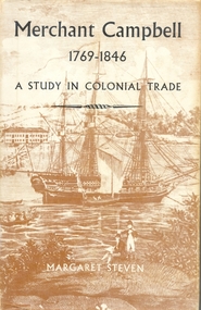
Book, Merchant Campbell 1749-1846: a study in colonial trade
... Merchant Campbell 1749-1846: a study in colonial trade..."Merchant Campbell 1749-1846: a study in colonial trade" - Margaret Steven, 1965....National Wool Museum 26 Moorabool Street Geelong geelong-and-the-bellarine-peninsula "Merchant Campbell 1749-1846: a study in colonial trade" - Margaret Steven, 1965. ..."Merchant Campbell 1749-1846: a study in colonial trade" - Margaret Steven, 1965.wool - history export - wool, wool - history, export - wool -
 Inverloch Historical Society
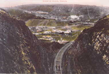
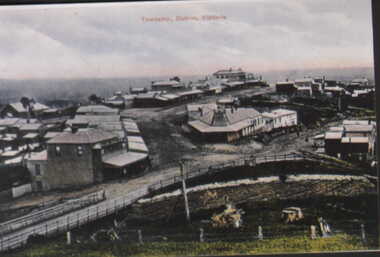
000450 Postcard - Scene of Outrim mine and township, Victoria - Should be Outtrim - Photocards by SGP Wonthaggi 5672 1749
... 000450 Postcard - Scene of Outrim mine and township, Victoria - Should be Outtrim - Photocards by SGP Wonthaggi 5672 1749...Inverloch gippsland 000450 Postcard - Scene of Outrim mine and township, Victoria - Should be Outtrim - Photocards by SGP Wonthaggi 5672 1749 ... -
 Inverloch Historical Society
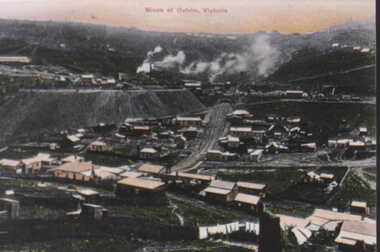
000451 Postcard - Mines at Outrim, Victoria - Should be Outtrim - Photocards by SGP Wonthaggi 5672 1749
... 000451 Postcard - Mines at Outrim, Victoria - Should be Outtrim - Photocards by SGP Wonthaggi 5672 1749...Inverloch gippsland 000451 Postcard - Mines at Outrim, Victoria - Should be Outtrim - Photocards by SGP Wonthaggi 5672 1749 ... -
 Inverloch Historical Society
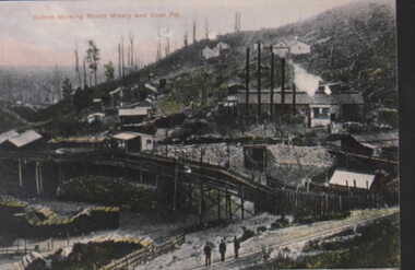
000452 Postcard - Outrim showing Mount Misery and Coal Pit - Should be Outtrim - Photocards by SGP Wonthaggi 5672 1749
... 000452 Postcard - Outrim showing Mount Misery and Coal Pit - Should be Outtrim - Photocards by SGP Wonthaggi 5672 1749...Inverloch gippsland 000452 Postcard - Outrim showing Mount Misery and Coal Pit - Should be Outtrim - Photocards by SGP Wonthaggi 5672 1749 ... -
 Inverloch Historical Society
000453 Postcard - Township Outrim, Victoria - Should be Outtrim - Photocards by SGP Wonthaggi 5672 1749
... 000453 Postcard - Township Outrim, Victoria - Should be Outtrim - Photocards by SGP Wonthaggi 5672 1749...Inverloch gippsland 000453 Postcard - Township Outrim, Victoria - Should be Outtrim - Photocards by SGP Wonthaggi 5672 1749 ... -
 Charlton Golden Grains Museum Inc
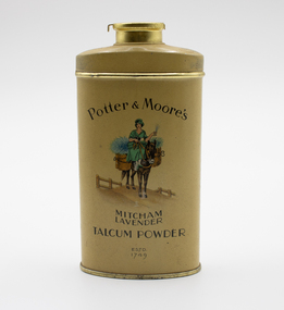
Domestic object - Tin of Talcum Powder (Full)
... Established 1749...Charlton Golden Grains Museum Inc 1 High Street Charlton goldfields Ladies Personal Toiletries Potter & Moore Talc toiletries talcum powder Established 1749 Potter & Moores Lavender Talcum Powder, Mustard Coloured Tin, Lady on horse and bundles of lavender on front Domestic object Tin of Talcum Powder (Full) ...Potter & Moores Lavender Talcum Powder, Mustard Coloured Tin, Lady on horse and bundles of lavender on frontEstablished 1749ladies personal toiletries, potter & moore talc, toiletries, talcum, powder -
 Mont De Lancey
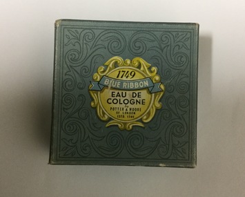
Toiletries, Potter & Moore
... Made by Potter & Moore, established in 1749....Made by Potter & Moore, established in 1749. Toiletries Potter & Moore ...Blue Ribbon Potter & Moore Eau De Cologne face powder. Shade - Rachel - in round blue patterned box. Made by Potter & Moore, established in 1749.toiletries, face powders -
 Running Rabbits Military Museum operated by the Upwey Belgrave RSL Sub Branch
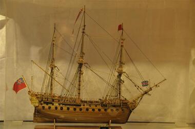
Model
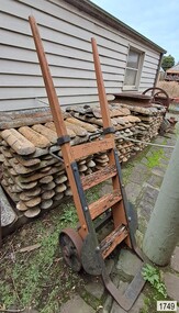
... ...1749...Running Rabbits Military Museum operated by the Upwey Belgrave RSL Sub Branch 1 Mast Gully Road Upwey melbourne Model 1749 Sailing ship Royal Caroline Model ...Sailing ship Royal Carolinemodel, 1749 -
 Bendigo Historical Society Inc.
Administrative record - Land Act 1901, no. 1749
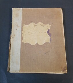
... Brown, beige book titled: Land Act 1901, No. 1749. at the back there are four amendments No. 1831 from 6th April 1903; No. 1957from 30Th November 1904; No 1991from 5th December. 1905 and No. 2228 from 4th January 1910....Administrative record Land Act 1901, no. 1749 ...Brown, beige book titled: Land Act 1901, No. 1749. at the back there are four amendments No. 1831 from 6th April 1903; No. 1957from 30Th November 1904; No 1991from 5th December. 1905 and No. 2228 from 4th January 1910.On the front and back cover in pen and pencil lists of land sales. On the first page in red "Land Office Bendigo"legislation, land act 1901, government -
 Bendigo Historical Society Inc.
Document - CORRESPONDENCE RE: HAROLD CURNOW
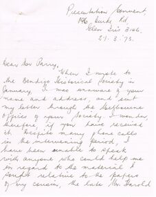
... Request for 'material' relevant to papers of cousin Harold Curnow- material to supplement being especially 'The House of Neill 1749 - 1949' and the 'Haddington Register for 1857' (''of which Harold was the proud possessor''). ...Request for 'material' relevant to papers of cousin Harold Curnow- material to supplement being especially 'The House of Neill 1749 - 1949' and the 'Haddington Register for 1857' (''of which Harold was the proud possessor''). ...Correspondence re Harold Curnow to BHS from Sister Junemarie Mason 14/4/1973. Request for 'material' relevant to papers of cousin Harold Curnow- material to supplement being especially 'The House of Neill 1749 - 1949' and the 'Haddington Register for 1857' (''of which Harold was the proud possessor''). BHS unable to help.Sister Junemarie Masonperson, individual, harold curnow -
 Orbost & District Historical Society
bottle, 1930's
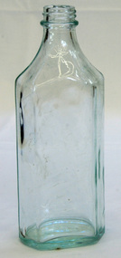
A clear glass bottle which is hexagonal shaped. It has a threaded top. The front face is flat and the back and sides are curved.On the base- AGM 1SM45 6bottle australian-glass-manufacturers container -
 Greensborough Historical Society
Photograph - Digital Image, Aftermath of Plenty River flood 1972 in Poulter Reserve. (4), 1972_
Plenty River in flood around the Poulter Reserve. There were two major floods in Greensborough at the time, 1972 and 1974. Poulter Reserve was created after the 1972 flood and had to be re-established following the 1974 flood.Digital copy of black and white photograph.plenty river, floods -
 Running Rabbits Military Museum operated by the Upwey Belgrave RSL Sub Branch
Firearm
Martini Henry / Enfield, .45, Lever Action single shot, Zulu Warweapon, 1887, army -
Port Melbourne Historical & Preservation Society
Document - Assignment, Evolution of planning controls for the Port Melbourne foreshore, 1994-2002, Janet Bolitho, May 2002
Assignment (completed while working on post graduate degree) arises from the author's experience of campaigning against high rise development for Port Melbourne as a member of Residents for Responsible Development, 1990sAssignment on the evolution of planning controls for the Port Melbourne foreshore, 1994-2002; 13pp with attachmentstown planning, built environment, public action campaigns, residents for responsible development, janet bolitho, samdy nominees (bayshore), envelope factory (bayview), becton, teac, hmas lonsdale -
Glenelg Shire Council Cultural Collection
Photograph - Photograph - "Al-Qurain", Kuwait, live sheep transport ship at dock, n.d
Port of Portland Authority archivesFront: (no inscriptions) Back: (no inscriptions)port of portland archives -
 Ballarat Tramway Museum
Functional object - Destination Roll, Melbourne and Metropolitan Tramways Board (MMTB), "Camberwell Depot", 1950's
Destination roll that was used in Camberwell Depot trams, Melbourne, until the late 1960's. Roll on linen, with white letters on black background. Has stencilled words "STOP CAMB" on bottom of roll, generally stencilled, though a few handwritten, miniature destination on rear to assist driver to locate the destination. Letters approx. 140 high. Roll consists of an unpainted section 525 long at top and 165 long unpainted section at base. Painted section approx. 9.9m long. Has on the bottom of the roll, a section which has been added to the roll or repaired by adding a new section. Some repainting of the old destinations also apparent. The middle of three "CITY" destinations and other parts adjacent have been repaired. Image information - btm1748i1 to 1747i9 - photos of various sections of roll from top to bottom - shows level of damage. btm1749i10, shows repair to the middle of the three "CITY" destinations. btm1749i4 shows the damage from the main side. For listing of destinations - see images.tram, trams, melbourne, camberwell depot, destination roll, mmtb -
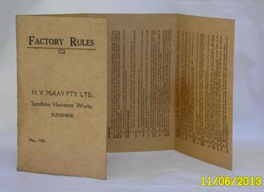 Sunshine and District Historical Society Incorporated
Booklet - H.V. McKay Pty Ltd Sunshine Harvester Works Sunshine Factory Rules May 1926, Possibly 1926
Light tan colored cardboard document folded into four sections. Contains Factory Rules for employees of the H. V. McKay Sunshine Harvester Works in Sunshine Victoria - May 1926.Factory Rules H.V. McKay Pty Ltd Sunshine Harvester Works Sunshine May 1926factory rules, h. v. mckay, sunshine harvester works, sunshine harvester factory -
National Vietnam Veterans Museum (NVVM)
Manual, Australian Army: AUST MT 136: Identification list provisional for tank, medium gun, Centurion, MK 5 (Mark 5)
australia - armed forces - service manuals -
Clunes Museum
Artwork, other - WATER COLOUR
WATER COLOUR OF RIVERGUM TREE PAINTED BY N.H.E.McDONALDLARGE RIVER GUMS IN FOREGROUND. FIVE SHEEP IN SHADE IN RURAL SETTING.RIVER GUMS MURRABIT WEST, VICTORIA. N.H.E. McDONALD local history, illustration, watercolour, mcdonald -
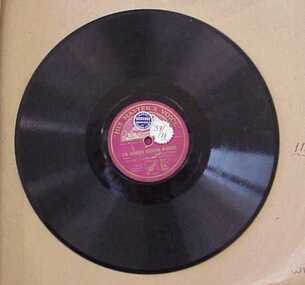 National Wool Museum
Record, Gramophone, Three o'clock in the morning / I'm forever blowing bubbles
Gramophone record used in the mending room of the Foster Valley Mill.textile mills staff, valley worsted mill, gramophone, record, textile mills - staff -
 Stawell Historical Society Inc
Medal, 1945
A.I.F. Defence Medal 1939 – 1945. W.S. Larkinstawell, ww2 -
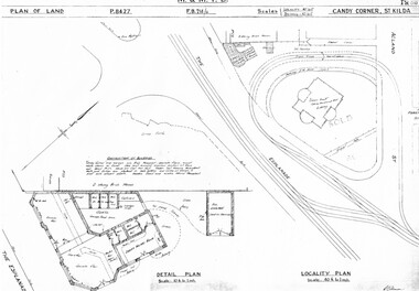 Melbourne Tram Museum
Drawing, Melbourne & Metropolitan Tramways Board (MMTB), "Candy Corner St Kilda", c1938
Set of two photocopied plans or drawings on A3 sheets of "Candy Corner St Kilda" .1 - P8427 - Plan showing locality plan, detail plan and adjacent buildings - 6-12-1938 .2 - ditto, but not the detail of the building in the centre of the island - "Green Knoll" Cafe and Amusement Park.trams, tramways, drawings, depots, property, candy corner, st kilda, turning loops -
 Flagstaff Hill Maritime Museum and Village
Functional object - Hand Trolley, Melbourne Steamship Company (MSS Co), Late 19th to mid-20th century
This hand trolley was originally marked M.S.S. Co., and likely to have once belonged to the Melbourne Steamship Company, often referred to by those initials. Flagstaff Hill’s collection has several other objects connected to the M.S.S. Co. The firm was established in 1873 under the name Hugh R. Reid and Company, renamed Melbourne Steamship Company Ltd in 1895, and became Melbourne’s foremost interstate shipping line. Warrnambool was one of the ports of call at least between 1922 and 1956; for example, on September 27 1934, the ship Coolana left Warrnambool on its way to Stanley, Burnie and Devonport, then on to Sydney and Newcastle, while other of its vessels were visiting Fremantle, Port Lincoln, Whyalla, Adelaide, and Melbourne. The firm remained in business until around 1960. A hand trolley can be loaded with heavy and bulky objects such as luggage, and stacks of boxes such as produce, cargo and equipment. It uses the principles of wheels and leverage, like a wheelbarrow, and can easily be wheeled from one place to another. Hand trolleys are still used by farmers, railway workers, shipping companies, porters, airports, hospitals, warehouses, logistical firms, furniture removalists, factory labourers and even in private homes when heavy loads need to be moved. Hand trolleys were first used in the 18th century in industries where children were used to move heavy loads. By using a hand trolley, the young labourers could move the piles of objects with the same efficiency as the adult workers. This hand trolley is significant for its likely connection to the Melbourne Steamship Company, or MSSCo, Melbourne’s foremost shipping line for interstate trade in the late nineteenth and early-to- mid twentieth century, representing many aspects of early trade within maritime Australia; Warrnambool was one of the ports visited by the company’s ships. The design of the hand trolley is an example of equipment used since the 18th century to move heavy loads at docks and shipyards. It is associated with the maritime industries of shipping, transportation, travel, and trade, as well as the colonial primary production sectors of farming, markets, and produce. The design represents an early step in the evolution of the simple hand trolley. More recently, as well as the continued use of this simple style of trolley, the design has been improved to include specialised trolleys that fold, climb stairs, move pianos and even easily turn corners on their spinning, pivoting wheels. Hand trolley: an L-shaped handcart with handles and supporting legs at one end, wheels at the other, and a ledge or platform to hold the load. This hand trolley has orange wooden slats and handles, two metal wheels, and a black metal frame with semi-circular side flanges. An inscription is stamped on one side.Stamped: "M.S.S.CO."warrnambool, flagstaff-hill, flagstaff-hill-maritime-museum, maritime-museum, shipwreck-coast, flagstaff-hill-maritime-village, hand trolley, sack truck, trolley, luggage trolley, hand truck, trundler, sack barrow, bag barrow, leverage, marine technology, cargo handling, docks, wharft, shipping, trade, vintage, antique, hand card, rolling cart, station trolley, dolly, stack truck, box cart, two-wheeler, material handling equipment, shipping trade, mss co, mssc, melbourne steamship company, interstate shipping, hugh r. reid and company -
Alfred Hospital Nurses League - Nursing History Collection
Container - Glass bottle, Potter & Moore Mitcham lavender smelling salts bottle, [ca.1930's]
... The brand Potter & Moore was established in 1749 one of the oldest toiletry and fragrance houses in England. ...The brand Potter & Moore was established in 1749 one of the oldest toiletry and fragrance houses in England. ...The brand Potter & Moore was established in 1749 one of the oldest toiletry and fragrance houses in England. Mitcham lavender was historically grown in the Mitcham area of south London. Smelling salts were a standard remedy kept in purses and first aid kits to revive people from fainting spells or dizziness. Traditional smelling salts rely on ammonia to trigger an inhalation reflex. Infusing the crystals with lavender oil masked the harsh chemical stingHistoric first aid treatmentGrenade shaped glass bottle with white plastic lid, containing the original solid salt crystals. Oblong label, purple and gilt on white background on which is printed manufacturer and content detailsfirst aid, smelling salts, lavender -
 Flagstaff Hill Maritime Museum and Village
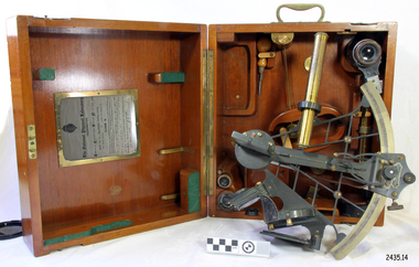
Instrument - Navigational Sextant, 1882-1890
... The sextant had been attributed to by John Hadley (1682–1744) and Thomas Godfrey (1704–1749), but reference to the sextant was also found later in the unpublished writings of Isaac Newton (1643–1727). ...The sextant had been attributed to by John Hadley (1682–1744) and Thomas Godfrey (1704–1749), but reference to the sextant was also found later in the unpublished writings of Isaac Newton (1643–1727). ...A sextant is an astronomical instrument used to determine latitude and longitude at sea by measuring angular distances, especially the altitudes of the sun, moon, and stars. It is a doubly reflecting navigation instrument and used mainly by sailors to measure the angular distance between two visible objects. The name comes from the Latin sextans, or “sixth part of a unit,” because the sextant’s arc can be 60° or 120° of a circle depending on the model used. The primary use was to measure the angle between an astronomical object and the horizon for the purposes of celestial navigation. The estimation of this angle is known as sighting or shooting the object, or taking a sight. This angle and the time when it was measured is used in order to determine Greenwich Mean Time and hence longitude. Sighting the height of a landmark on land can also give a measure of distance from that object. History: The development of the sextant was as an improvement over the octant, an instrument designed to measure one's latitude. The octant was first implemented around 1731-present but can only measure angles up to 45°. As larger angles were needed to allow the measurement of lunar objects - moon, stars and the sun - at higher angles, the octant was superseded by the sextant. The sextant is a similar instrument but better made and allows larger angles from 60° to 120°. This improvement allows distances to be accurately calculated thereby giving longitude when used with a chronometer. The sextant was derived from the octant in 1757, eventually making all previous instruments used for navigational positioning obsolete. The sextant had been attributed to by John Hadley (1682–1744) and Thomas Godfrey (1704–1749), but reference to the sextant was also found later in the unpublished writings of Isaac Newton (1643–1727). Earlier links can be found to Bartholomew Gosnold (1571–1607) indicating that the use of a sextant for nautical navigation predates Hadley's implementation. In 1922, the sextant was modified for aeronautical navigation by Portuguese navigator and naval officer Gago Coutinho. It should be noted that the octant and quadrant are in the same family as they were, and all are, regarded as sextants. The sextant is representative of it's type and although not fully complete it demonstrates how 18th,19th and 20th century mariners determined their latitude and longitudinal to determine their position on a chart, allowing them to navigate there way across the world's oceans. It also demonstrates the skill and workmanship of the early instrument makers that operated scientific instrument businesses from London and other areas of England to provide most of the navigational instrumentation used by commercial and military navies of the time.Sextant with square, fitted box of polished wood, "Hezzanith" brand. Box contains many parts for the sextants use. On certificate "Heath & Co, London. Sextant Number Y 822". Catch on lid "DEFIANT LEVER" and "PATENT NUMBER 187.10". Maker's certificate is attached to the inside of the box.flagstaff hill, warrnambool, shipwrecked-coast, flagstaff-hill, flagstaff-hill-maritime-museum, maritime-museum, shipwreck-coast, flagstaff-hill-maritime-village, sextant box, sextant, hezzanith, heath & co, navigational instrument, george wilson heath, astronomical instrument, instrument manufacturers, scientific instrument, navigation, celestial navigation, octant, quadrant, lunar navigation -
 Flagstaff Hill Maritime Museum and Village
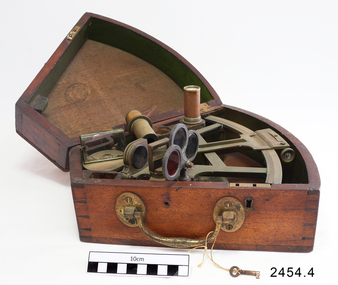
Octant, Mid to late 19th Century
... Two men independently developed the octant around 1730: John Hadley (1682–1744), an English mathematician, and Thomas Godfrey (1704–1749), a glazier in Philadelphia. While both have a legitimate and equal claim to the invention, Hadley generally gets the greater share of the credit. ...Two men independently developed the octant around 1730: John Hadley (1682–1744), an English mathematician, and Thomas Godfrey (1704–1749), a glazier in Philadelphia. While both have a legitimate and equal claim to the invention, Hadley generally gets the greater share of the credit. ...An octant is an astronomical instrument used in measuring the angles of heavenly bodies such as the sun, moon and stars at sea in relation to the horizon. This measurement could then be used to calculate the altitude of the body measured, and then the latitude at sea could also be calculated. The angle of the arms of an octant is 45 degrees, or 1/8 of a circle, which gives the instrument its name. Two men independently developed the octant around 1730: John Hadley (1682–1744), an English mathematician, and Thomas Godfrey (1704–1749), a glazier in Philadelphia. While both have a legitimate and equal claim to the invention, Hadley generally gets the greater share of the credit. This reflects the central role that London and the Royal Society played in the history of scientific instruments in the eighteenth and nineteenth century's. There were also two others who are attributed to having created octanes during this period, Caleb Smith, an English insurance broker with a strong interest in astronomy (in 1734), and Jean-Paul Fouchy, a mathematics professor and astronomer in France (in 1732) In 1767 the first edition of the Nautical Almanac tabulated lunar distances, enabling navigators to find the current time from the angle between the sun and the moon. This angle is sometimes larger than 90°, and thus not possible to measure with an octant. For that reason, Admiral John Campbell, who conducted shipboard experiments with the lunar distance method, suggested a larger instrument and the sextant was developed. From that time onward, the sextant was the instrument that experienced significant development and improvements and was the instrument of choice for naval navigators. The octant continued to be produced well into the 19th century, though it was generally a less accurate and less expensive instrument. The lower price of the octant, including versions without a telescope, made it a practical instrument for ships in the merchant and fishing fleets. One common practice among navigators up to the late nineteenth century was to use both a sextant and an octant. The sextant was used with great care and only for lunar sightings while the octant was used for routine meridional altitude measurements of the sun every day. This protected the very accurate and pricier sextant while using the more affordable octant for general use where it performs well. The invention of the octant was a significant step in providing accuracy of a sailors latitude position at sea and his vessels distance from land when taking sightings of land-based landmarks.Octant with metal handle, three different colored shades are attached, in wooden wedge-shaped box lined with green felt. Key is attached. Two telescope eyepieces are in box. Some parts are missing. Oval ink stamp inside lid of box, scale is graduated to 45 degrees. Ink stamp inside lid of box "SHIPLOVERS SOCIETY OF VICTORIA. LIBRARY"instrument, flagstaff hill, warrnambool, shipwrecked coast, flagstaff hill maritime museum, maritime museum, shipwreck coast, flagstaff hill maritime village, great ocean road, octant, navigation, nautical instrument, navigation instrument, john hadley, sextant, astronomical instrument -
 Flagstaff Hill Maritime Museum and Village
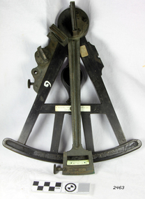
Octant, Late 18th to mid-19th century
... The sextant started to appear around 1730 and had been attributed to by John Hadley (1682–1744) and Thomas Godfrey (1704–1749), but reference to the sextant was also found later in the unpublished writings of Isaac Newton (1643–1727). ...The sextant started to appear around 1730 and had been attributed to by John Hadley (1682–1744) and Thomas Godfrey (1704–1749), but reference to the sextant was also found later in the unpublished writings of Isaac Newton (1643–1727). ...An Octant is a doubly reflecting navigation instrument used primarily by sailors to measure the angular distance between two visible objects and was a forerunner of the sextant. The name comes from the Latin octo, or “one-eighth of a circle,” for the Octant’s arc which spans 45°, or one-eighth of a circle. The primary use of an Octant is to measure the angle between an astronomical object and the horizon for the purposes of celestial navigation. The estimation of this angle is known as sighting or shooting the object, or taking a sight. The angle, and the time when it was measured, can be used to calculate a position line on a nautical chart (latitude), for example, sighting the Sun at noon or Polaris at night (in the Northern Hemisphere) gives an angle by which the latitude can then be estimated. Sighting the height of a landmark on land can also give a measure of distance. History: The principle of the Octant as an instrument to measure ones latitude was first implemented around 1742-present but was superseded by the improvement of the octant to a sextant, a very similar instrument, better made and able to measure bigger angles 120°, allowing the measurement of Luna distances to give longitude when used with an accurate chronometer. The sextant started to appear around 1730 and had been attributed to by John Hadley (1682–1744) and Thomas Godfrey (1704–1749), but reference to the sextant was also found later in the unpublished writings of Isaac Newton (1643–1727). Earlier links can be found to Bartholomew Gosnold (1571–1607) indicating that the use of a Sextant for nautical navigation predates Hadley's implementation. In 1922, the sextant was modified for aeronautical navigation by Portuguese navigator and naval officer Gago Coutinho. Henry Hemsley was a lesser-known instrument maker and optician working in London in the late 17th and early 18th century. However, it should be noted that there were two Henry Hemsley opticians and instrument makers around this period. (Henry Hemsley 1, 1786-89, who had premises at 85 Fleet St London and Henry Hemsley 2, 1828-56), whose workshop was at 135-138 Radcliff Highway London. Therefore, based on the inscribed workshop address Henry Hemsley 2 is responsible for making this example.The octant is representative of its type and although not fully complete it demonstrates how 18th and 19th-century mariners determined their latitude on a chart to navigate their way across the world's oceans in the 18th and 19th century. It also demonstrates the skill and workmanship of the early instrument makers that operated from London at this time and provided most of the navigational instrumentation use by commercial and military navies of the time.Octant, ebony wooden frame and handle. Scale is missing from recess in frame. "H. Hemsley 135-138 Ratliff Highway, London", no box"H. Hemsley 135-138 Ratcliff Highway, London"flagstaff hill, warrnambool, shipwrecked-coast, flagstaff-hill, flagstaff-hill-maritime-museum, maritime-museum, shipwreck-coast, flagstaff-hill-maritime-village, navigation, navigational instrument, instrument used for navigation, sextant, henry hemsley, instrument maker, london, octant -
 Flagstaff Hill Maritime Museum and Village
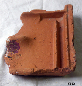
Tile, c 1914
... She was a three masted, 1749 ton iron clipper, built in Glasgow in 1888 and originally named and launched as the Sutlej. ...She was a three masted, 1749 ton iron clipper, built in Glasgow in 1888 and originally named and launched as the Sutlej. ...This clay roof tile was part of the ANTARES cargo, a large consignment of tiles on its way to Melbourne. THE ANTARES In mid-November 1914, after the beginning of the First World War, a young local man went one evening to fish near the Bay of Islands, west of Peterborough. He later arrived home hurriedly and in an agitated state declaring: "The Germans are coming!" His family laughed and disbelieved him, as this young fellow was prone to telling fictional tales. About a month later, on December 13th 1914, local farmers Phillip Le Couteur and Peter Mathieson were riding in the vicinity, checking on cattle. Phillip Le Couteur saw what he “thought was the hull of a ship below the cliffs.” He rode to Allansford and contacted police. The next day, two Constables and Phillip Le Couteur returned to the site, where they dug a trench near the top of the cliff and sank a log in it. To this they attached a rope, which they threw down the cliff face. Constable Stainsbury and Phillip Le Couteur then made the dangerous descent down the rope on the sheer cliff face. They found wreckage strewn around a small cove and a portion of a man's body under the cliffs. The hull of the ship could be seen about 300 metres out to sea. Some of the wreckage revealed the name Antares and the remains of the ship's dinghy bore the name Sutlej. During the next two weeks and with the help of the Warrnambool lifeboat and crew, two more bodies were found. Later investigations proved that the tragic wreck was indeed that of the Antares, reported overdue on the 207th day of her voyage from Marseilles, France, to Melbourne. She was a three masted, 1749 ton iron clipper, built in Glasgow in 1888 and originally named and launched as the Sutlej. Bought in 1907 by Semider Bros. from Genoa, Italy, she was refitted and renamed Antares. It was later realised that the local lad who a month earlier had declared he had seen German guns being fired, had probably seen distress flares fired from the deck of the Antares the night she was wrecked. She was last sailed under Captain Gazedo and wrecked at what is now known as Antares Rock, near the Bay of Islands. She had been carrying a large cargo of roof tiles from France to Melbourne, consigned to Mullaly & Byrne. Many of them are now to be seen amongst the battered and scattered remains of the wreck. Some of the timbers were found to be blackened by fire. An Information Board has been erected on the cliff top near to the site of the Antares wreck, at the end of Radfords Rd, west of Peterborough. (Ref: Flagstaff Hill Maritime Village’s “Antares” fact sheet, Victorian Heritage Database, Information Board at Peterborough, Flagstaff Hill Significance Assessment 2010) The Antares was one of the last of the 'tall ships' to be lost along the south west coast of Victoria, and is the only wreck that took the lives of all people on board. She is listed on the Victorian Heritage Register VHS S34. The Antares is significant as a sail trader carrying an international inbound cargo. It is part of the Great Ocean Road Historic Shipwreck Trail. Piece of a clay roof tile recovered from the wreck of the Antares. Has a relief of a horse on back. Artefact Reg No A/7.flagstaff hill, warrnambool, shipwrecked-coast, flagstaff-hill, flagstaff-hill-maritime-museum, maritime-museum, shipwreck-coast, flagstaff-hill-maritime-village, antares, tall ship, peterborough, 1914 shipwreck, phillip le couteur, peter mathieson, constable stainsbury, sutlej, antares rock., bay of islands, clay tile, roofing tile, roof tile -
 Flagstaff Hill Maritime Museum and Village
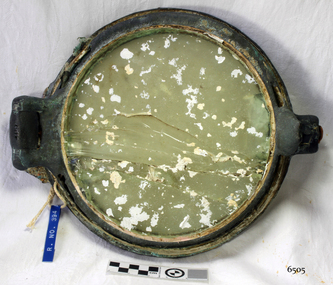
Functional object - Porthole, c 1888
... She was a three masted, 1749 ton iron clipper, built in Glasgow in 1888 and originally named and launched as the Sutlej. ...She was a three masted, 1749 ton iron clipper, built in Glasgow in 1888 and originally named and launched as the Sutlej. ...This porthole was part of the ship's fittings when the Antares was constructed. THE ANTARES In mid-November 1914, after the beginning of the First World War, a young local man went one evening to fish near the Bay of Islands, west of Peterborough. He later arrived home hurriedly and in an agitated state declaring: "The Germans are coming!" His family laughed and disbelieved him, as this young fellow was prone to telling fictional tales. About a month later, on December 13th 1914, local farmers Phillip Le Couteur and Peter Mathieson were riding in the vicinity, checking on cattle. Phillip Le Couteur saw what he “thought was the hull of a ship below the cliffs.” He rode to Allansford and contacted police. The next day, two Constables and Phillip Le Couteur returned to the site, where they dug a trench near the top of the cliff and sank a log in it. To this they attached a rope, which they threw down the cliff face. Constable Stainsbury and Phillip Le Couteur then made the dangerous descent down the rope on the sheer cliff face. They found wreckage strewn around a small cove and a portion of a man's body under the cliffs. The hull of the ship could be seen about 300 metres out to sea. Some of the wreckage revealed the name Antares and the remains of the ship's dinghy bore the name Sutlej. During the next two weeks and with the help of the Warrnambool lifeboat and crew, two more bodies were found. Later investigations proved that the tragic wreck was indeed that of the Antares, reported overdue on the 207th day of her voyage from Marseilles, France, to Melbourne. She was a three masted, 1749 ton iron clipper, built in Glasgow in 1888 and originally named and launched as the Sutlej. Bought in 1907 by Semider Bros. from Genoa, Italy, she was refitted and renamed Antares. It was later realised that the local lad who a month earlier had declared he had seen German guns being fired, had probably seen distress flares fired from the deck of the Antares the night she was wrecked. She was last sailed under Captain Gazedo and wrecked at what is now known as Antares Rock, near the Bay of Islands. She had been carrying a large cargo of roofing tiles from France to Melbourne, consigned to Mullaly & Byrne. Many of them are now to be seen amongst the battered and scattered remains of the wreck. Some of the timbers were found to be blackened by fire. An Information Board has been erected on the cliff top near to the site of the Antares wreck, at the end of Radfords Rd, west of Peterborough. (Ref: Flagstaff Hill Maritime Village’s “Antares” fact sheet, Victorian Heritage Database, Information Board at Peterborough, Flagstaff Hill Significance Assessment 2010)The Antares was one of the last of the 'tall ships' to be lost along the south west coast of Victoria, and is the only wreck that took the lives of all people on board. She is listed on the Victorian Heritage Register VHS S34. The Antares is significant as a sail trader carrying an international inbound cargo. It is part of the Great Ocean Road Historic Shipwreck Trail. Porthole with glass, brass, screw dog broken off, glass has cracks through it, some encrustation. Artefact Reg No A/5, recovered from the wreck of the Antares.flagstaff hill, warrnambool, shipwrecked-coast, flagstaff-hill, flagstaff-hill-maritime-museum, maritime-museum, shipwreck-coast, flagstaff-hill-maritime-village, porthole, antares., tall ship, peterborough, 1914 shipwreck, phillip le couteur, peter mathieson, constable stainsbury, sutlej, antares rock., bay of islands, ship's fitting -
 Flagstaff Hill Maritime Museum and Village
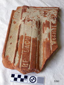
Ceramic - Roof Tile, c 1914
... She was a three masted, 1749 ton iron clipper, built in Glasgow in 1888 and originally named and launched as the Sutlej. ...She was a three masted, 1749 ton iron clipper, built in Glasgow in 1888 and originally named and launched as the Sutlej. ...This terracotta clay roof tile was part of a consignment of tiles in the cargo of ANTARES. THE ANTARES In mid-November 1914, after the beginning of the First World War, a young local man went one evening to fish near the Bay of Islands, west of Peterborough. He later arrived home hurriedly and in an agitated state declaring: "The Germans are coming!" His family laughed and disbelieved him, as this young fellow was prone to telling fictional tales. About a month later, on December 13th 1914, local farmers Phillip Le Couteur and Peter Mathieson were riding in the vicinity, checking on cattle. Phillip Le Couteur saw what he “thought was the hull of a ship below the cliffs.” He rode to Allansford and contacted police. The next day, two Constables and Phillip Le Couteur returned to the site, where they dug a trench near the top of the cliff and sank a log in it. To this they attached a rope, which they threw down the cliff face. Constable Stainsbury and Phillip Le Couteur then made the dangerous descent down the rope on the sheer cliff face. They found wreckage strewn around a small cove and a portion of a man's body under the cliffs. The hull of the ship could be seen about 300 metres out to sea. Some of the wreckage revealed the name Antares and the remains of the ship's dinghy bore the name Sutlej. During the next two weeks and with the help of the Warrnambool lifeboat and crew, two more bodies were found. Later investigations proved that the tragic wreck was indeed that of the Antares, reported overdue on the 207th day of her voyage from Marseilles, France, to Melbourne. She was a three masted, 1749 ton iron clipper, built in Glasgow in 1888 and originally named and launched as the Sutlej. Bought in 1907 by Semider Bros. from Genoa, Italy, she was refitted and renamed Antares. It was later realised that the local lad who a month earlier had declared he had seen German guns being fired, had probably seen distress flares fired from the deck of the Antares the night she was wrecked. She was last sailed under Captain Gazedo and wrecked at what is now known as Antares Rock, near the Bay of Islands. She had been carrying a large cargo of roof tiles from France to Melbourne, consigned to Mullaly & Byrne. Many of them are now to be seen amongst the battered and scattered remains of the wreck. Some of the timbers were found to be blackened by fire. An Information Board has been erected on the cliff top near to the site of the Antares wreck, at the end of Radfords Rd, west of Peterborough. (Ref: Flagstaff Hill Maritime Village’s “Antares” fact sheet, Victorian Heritage Database, Information Board at Peterborough, Flagstaff Hill Significance Assessment 2010) The Antares was one of the last of the 'tall ships' to be lost along the south west coast of Victoria, and is the only wreck that took the lives of all people on board. She is listed on the Victorian Heritage Register VHS S34. The Antares is significant as a sail trader carrying an international inbound cargo. It is part of the Great Ocean Road Historic Shipwreck Trail.Part of a terracotta roof tile from the wreck of the Antares Has sand encrusted to bottom of tile. Artefact Reg No A/6.flagstaff hill, warrnambool, shipwrecked-coast, flagstaff-hill, flagstaff-hill-maritime-museum, maritime-museum, shipwreck-coast, flagstaff-hill-maritime-village, antares, tall ship, peterborough, 1914 shipwreck, phillip le couteur, peter mathieson, constable stainsbury, sutlej, antares rock., bay of islands, terracotta tile, roof tile, clay tile, roofing material, building material