Showing 42 items matching "1933 maps"
-
 Kiewa Valley Historical Society
Maps - Tourist
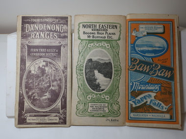
... 1933 Maps...These maps were all dated 1933 which was before the construction of the Kiewa Hydro Electric Scheme and when Tawonga was spelt Towonga. ...Tourist Map of North Eastern Victoria including Bogong High Plains Mt Buffalo Etc. Green cover. dated June 1933 Govt. printer. ...Poles about 3 chains apart 27 to the mile." 1933 Maps Tourism Maps Bogong High Plains Map 1933 snow poles By Authority of H.J. ...These maps were all dated 1933 which was before the construction of the Kiewa Hydro Electric Scheme and when Tawonga was spelt Towonga. North East Victoria in 1933 was before the construction of the Kiewa Hydro Electric Scheme so the townships of Mt Beauty and Bogong are not shown. The description of the Snow Lines was important as skiers, bushwalkers and campers relied on them. The details on the map include "ADB. Numbered from A.1-377 round plates. CD Numbered from C 1-235 square plates. Poles about 3 chains apart 27 to the mile." 3 Tourist location maps (folded) and printed on parchment. 1. Tourist map of the Dandenong Ranges. Brown cover. dated 6-4-33. Govt. printer showing roads, tracks in red and heights of the land. 2. Tourist Map of Warburton, Mt Baw Baw, and Walhalla. Blue and Orange cover. dated 23-5-33 Govt. printer. 3 different maps of each area showin roads, tracks and timber tramways.Also in red and blue. 3. Tourist Map of North Eastern Victoria including Bogong High Plains Mt Buffalo Etc. Green cover. dated June 1933 Govt. printer. Main map and insert titled Bogong High Plains. Showing roads , tracks and tram ways. On insert showing snow poles. Also Red and Blue and mountains.By Authority of H.J. Green - 6 pence. Dept of Lands and Survey, Melbourne1933 maps, tourism maps, bogong high plains map 1933, snow poles -
 Sunshine and District Historical Society Incorporated
Plan - Sunshine Harvester Works Map Collection
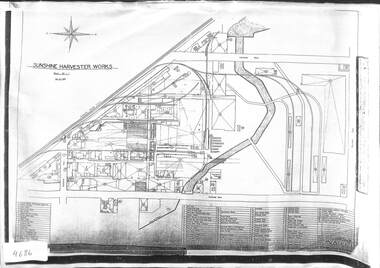
... 1922 Map|1927 Map|1933 Map|Undated aerial photograph...McKay Massey Harris Sunshine Harvester Works Map 1922 Map|1927 Map|1933 Map|Undated aerial photograph Photocopies of various maps and aerial photographs of the Sunshine Harvester Factory Plan Sunshine Harvester Works Map Collection ...1922 Map|1927 Map|1933 Map|Undated aerial photographh.v. mckay massey harris, sunshine harvester works, map -
 Whitehorse Historical Society Inc.
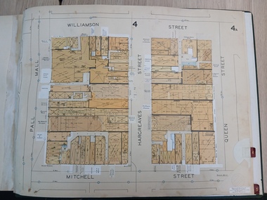
Map, Box Hill in 1883, c1933
... Map of Box Hill in 1883 showing churches, hotels, etc, linked to ND4231 '1933 map'...Whitehorse Historical Society Inc. 2-10 Deep Creek Road Mitcham melbourne Maps Box Hill Map of Box Hill in 1883 showing churches, hotels, etc, linked to ND 4231 '1933 map' Map of Box Hill in 1883 showing churches, hotels, etc, linked to ND4231 '1933 map' Box Hill in 1883 Map Map ...Map of Box Hill in 1883 showing churches, hotels, etc, linked to ND 4231 '1933 map'Map of Box Hill in 1883 showing churches, hotels, etc, linked to ND4231 '1933 map'Map of Box Hill in 1883 showing churches, hotels, etc, linked to ND 4231 '1933 map'maps, box hill -
Whitehorse Historical Society Inc.
Document, Particulars of maintainance works, 1933
... Shire of Blackburn and Mitcham - particulars of maintenance works carried out under the maintenance grant for the year ending 30 Jun 1933 and map showing work on the Main Healesville Road and Main Burwood Road....Shire of Blackburn and Mitcham - particulars of maintenance works carried out under the maintenance grant for the year ending 30 Jun 1933 and map showing work on the Main Healesville Road and Main Burwood Road. ...Shire of Blackburn and Mitcham - particulars of maintenance works carried out under the maintenance grant for the year ending 30 Jun 1933 and map showing work on the Main Healesville Road and Main Burwood Road.Shire of Blackburn and Mitcham - particulars of maintenance works carried out under the maintenance grant for the year ending 30 Jun 1933 and map showing work on the Main Healesville Road and Main Burwood Road.Shire of Blackburn and Mitcham - particulars of maintenance works carried out under the maintenance grant for the year ending 30 Jun 1933 and map showing work on the Main Healesville Road and Main Burwood Road.local government, shire of blackburn and mitcham, financial documents, maps, burwood road, healesville road, whitehorse road -
 Ballarat Tramway Museum
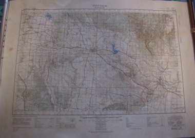
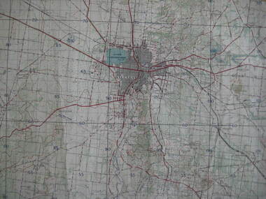
Map, Australian Survey Corps, "Victoria Ballan", 1933
... Topographic map of the Ballan area - includes Bacchus Marsh and Bungaree, No. 837, Zone 7, Army Map, dated 1933, 1:63360. Shows rail lines, roads, elevations, contours. ...Ballarat Tramway Museum South Gardens Reserve Wendouree Parade Ballarat Ballarat goldfields Trams tramways Bungaree Map Topographic map of the Ballan area - includes Bacchus Marsh and Bungaree, No. 837, Zone 7, Army Map, dated 1933, 1:63360. Shows rail lines, roads, elevations, contours. ...Topographic map of the Ballan area - includes Bacchus Marsh and Bungaree, No. 837, Zone 7, Army Map, dated 1933, 1:63360. Shows rail lines, roads, elevations, contours. Collected with relevance to the Museum's association with the area, at Bungareetrams, tramways, bungaree, map -
 Eltham District Historical Society Inc
Document - Folder, Survey Maps and Technical Drawings
... Military Survey Map: Ballan, Victoria, No. 837 Zone 7, Sheet South J55 GIII N.E & N.W., 1 inch to 1 mile, 1:63,360, Royal Australian Survey Corps, 1933 6. ...Military Survey Map: Ballan, Victoria, No. 837 Zone 7, Sheet South J55 GIII N.E & N.W., 1 inch to 1 mile, 1:63,360, Royal Australian Survey Corps, 1933 6. ...alan gardiner collection, maps -
 Bendigo Historical Society Inc.
Document - MCCOLL, RANKIN AND STANISTREET COLLECTION: NEW STAR GOLD MINE HARRIETVILLE NL, SOUTH BLUE CONSOLIDATED SYNDICATE
... 1933. e/ Memo & 3-page letter. Memo re surveyor for Dargo. Allotted shares exceeds available shares. Letter: To Wonnangatta Gold Reefs Syndicate regarding purchase of lease hold property in Mining District of Gippsland. Dated 28/6/1934. Signed ?? Page 2, Balance of monies advanced from R A Rankin. Page 3, costs Re Golden Butterfly Mine. f/ Agreement to lease property in Mining District of Gippsland Mining Lease No's 5187 & 5195 Black Snake Creek Dargo, blue print map...1933. e/ Memo & 3-page letter. Memo re surveyor for Dargo. Allotted shares exceeds available shares. Letter: To Wonnangatta Gold Reefs Syndicate regarding purchase of lease hold property in Mining District of Gippsland. Dated 28/6/1934. Signed ?? Page 2, Balance of monies advanced from R A Rankin. Page 3, costs Re Golden Butterfly Mine. f/ Agreement to lease property in Mining District of Gippsland Mining Lease No's 5187 & 5195 Black Snake Creek Dargo, blue print map ...McColl Rankin & Stanistreet, New Star Gold Mine Harrietville NL. Collection of documents in envelope. a/ Agreement with the unregistered mining syndicate South Blue Consolidated Syndicate and Gold Exploration (Victoria) Co ML application No. 9982 for a Gold Mining Lease of land at Bendigo on Southern Extension of the Sheepshead or Red White & Blue Line of Reef. Dated: 17/6/1932. Signatures: James Phillips, Stanistreet, J M Leed, C J Michelsen, Jardine?? MacKay. 2 pages. b/ Harry Raymond Johnson & Ellis Douglas McDonnel Doyle on behalf of a No Liability Company to be formed, application for Gold Mining Lease NO. 7514 (Beechworth). Vendors are taking steps to a Company to be entitled New Star Gold Mine Harrietville. Signed: ??, E? McDoyle, ??, McColl Rankin & Stanistreet, ?? Dated:1/5/19/33. 2 pages. c/ Indenture between Ellis Douglas McDonnell Doyle, Harry Raymond Johnson and New Star Gold Mine Harrietville NL the company was formed on 27/6/1933 registered and incorporated. Dated 28/6/1933. Signed: Ke? E D M Doyle, Murphy, Mary R Johnson, J Nicolsen, G? Stanistreet. 2 pages. d/ Memo attached to 2-page letter. Re: adjustment of number of shares for Mr. King. Letter acknowledging receipt of paid shares. Dated 25/7/1933. Signed C B King,?? Page 2 lists brokerage etc. for shares. Dated 11/7/1933. e/ Memo & 3-page letter. Memo re surveyor for Dargo. Allotted shares exceeds available shares. Letter: To Wonnangatta Gold Reefs Syndicate regarding purchase of lease hold property in Mining District of Gippsland. Dated 28/6/1934. Signed ?? Page 2, Balance of monies advanced from R A Rankin. Page 3, costs Re Golden Butterfly Mine. f/ Agreement to lease property in Mining District of Gippsland Mining Lease No's 5187 & 5195 Black Snake Creek Dargo, blue print map of Mine included of No.5187. Dated 28/6/1934. Signed: Keohan?, ??, G ?, Geo Kingsley, Stanistreet. 4 pages. g/ An option to purchase certain Applications for Gold Mining Leases. Date: 28/6/34. Signitures: ? M Neill, ??, G ?, J Nichelsen, Stanistreet. 2 Pages.bendigo, gold mining, south blue consolidated, mccoll rankin & stanistreet -
 Monbulk RSL Sub Branch
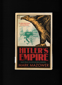
Book, Penguin, Hitler's empire : Nazi rule in occupied Europe, 2009
... Monbulk RSL Sub Branch 48 Main Road Monbulk yarra-valley-and-the-dandenong-ranges germany - history - 1933-1945 national socialism - germany Drawing on an unprecedented variety of sources, Mark Mazower reveals how the Nazis designed, maintained, and ultimately lost their European empire and offers a chilling vision of the world Hitler would have made had he won the war. Index, bibliography, notes, ill, maps ...Drawing on an unprecedented variety of sources, Mark Mazower reveals how the Nazis designed, maintained, and ultimately lost their European empire and offers a chilling vision of the world Hitler would have made had he won the war.Index, bibliography, notes, ill, maps, p.725.non-fictionDrawing on an unprecedented variety of sources, Mark Mazower reveals how the Nazis designed, maintained, and ultimately lost their European empire and offers a chilling vision of the world Hitler would have made had he won the war.germany - history - 1933-1945, national socialism - germany -
 Monbulk RSL Sub Branch
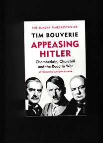
Book, Vintage, Appeasing Hitler : Chamberlain, Churchill and the road to war, 2020
... Drawing on previously unseen sources, it sweeps from the advent of Hitler in 1933 to the beaches of Dunkirk, and presents an unforgettable portrait of the ministers, aristocrats and amateur diplomats whose actions and inaction had devastating consequences. Index, bibliography, notes, ill, maps ...On a wet afternoon in September 1938, Neville Chamberlain stepped off an aeroplane and announced that his visit to Hitler had averted the greatest crisis in recent memory. It was, he later assured the crowd in Downing Street, 'peace for our time'. Less than a year later, Germany invaded Poland and the Second World War began. This is a vital new history of the disastrous years of indecision, failed diplomacy and parliamentary infighting that enabled Nazi domination of Europe. Drawing on previously unseen sources, it sweeps from the advent of Hitler in 1933 to the beaches of Dunkirk, and presents an unforgettable portrait of the ministers, aristocrats and amateur diplomats whose actions and inaction had devastating consequences.Index, bibliography, notes, ill, maps, p.497.non-fictionOn a wet afternoon in September 1938, Neville Chamberlain stepped off an aeroplane and announced that his visit to Hitler had averted the greatest crisis in recent memory. It was, he later assured the crowd in Downing Street, 'peace for our time'. Less than a year later, Germany invaded Poland and the Second World War began. This is a vital new history of the disastrous years of indecision, failed diplomacy and parliamentary infighting that enabled Nazi domination of Europe. Drawing on previously unseen sources, it sweeps from the advent of Hitler in 1933 to the beaches of Dunkirk, and presents an unforgettable portrait of the ministers, aristocrats and amateur diplomats whose actions and inaction had devastating consequences.great britain - politics and government - 1936-1945, great britain - diplomatic history -
 Monbulk RSL Sub Branch
Book, Penguin, The war against the Jews, 1933-45, 1987
... Index, bib, maps, p.556. The war against the Jews, 1933-45 Book Penguin Lucy S. ...In the first part, "The Final Solution," the author "records the origins and growth of the virulent ideology that underlay the plan to annihilate the European Jews," and in the second part, "The Holocaust," she describes "the Jewish plight under German terror.Index, bib, maps, p.556.non-fictionIn the first part, "The Final Solution," the author "records the origins and growth of the virulent ideology that underlay the plan to annihilate the European Jews," and in the second part, "The Holocaust," she describes "the Jewish plight under German terror.holocaust - jewish - 1939-1945, 1939-1945 - atrocities -
 Monbulk RSL Sub Branch
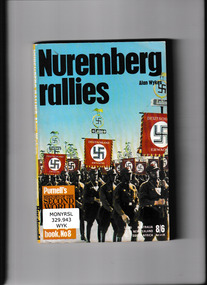
Book, Pan Books, Nuremberg rallies, 1969
... Monbulk RSL Sub Branch 48 Main Road Monbulk yarra-valley-and-the-dandenong-ranges Germany - Politics and government - 1933-1945 Germany - Nazi party The Nazi Party Nuremberg rallies Ill, maps, p.159. ...The Nazi Party Nuremberg ralliesIll, maps, p.159.non-fictionThe Nazi Party Nuremberg ralliesgermany - politics and government - 1933-1945, germany - nazi party -
 Monbulk RSL Sub Branch
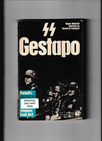
Book, Pan Books, SS and Gestapo: Rule by terror, 1969
... Monbulk RSL Sub Branch 48 Main Road Monbulk yarra-valley-and-the-dandenong-ranges Germany - Politics and government - 1933-1945 Secret police - Germany Hitlers terror organisations - the SS and Gestapo Ill, maps, p.159. ...Hitlers terror organisations - the SS and GestapoIll, maps, p.159.non-fictionHitlers terror organisations - the SS and Gestapogermany - politics and government - 1933-1945, secret police - germany -
 Bendigo Historical Society Inc.
Document - MCCOLL, RANKIN AND STANISTREET COLLECTION: LEASE AGREEMENT, 24th November, 1933
... 1933. Also in the envelope is a lease document for mining Lease No. 9993, for the Central Garden Gully Gold Mining Co. NL which includes a map...1933. Also in the envelope is a lease document for mining Lease No. 9993, for the Central Garden Gully Gold Mining Co. NL which includes a map ...Manilla Envelope containing 3 copies of a Lease agreement between John Taylor of California Gully and John Severn Barker of Jobs Gully for a company called the Garden Gully and Moon Extended Gold Mines NL. These men are the holders of an application for Gold Mining lease 10073 comprising about 90 acres in the Parishes of Yarraberb and Neilborough. The company is being formed to acquire the application for the lease and to carry out mining operations on and in the land comprised in the lease application. Dated 24th November 1933. Also in the envelope is a lease document for mining Lease No. 9993, for the Central Garden Gully Gold Mining Co. NL which includes a map of the lease. Written in pencil on the front of the lease is : allowed to lapse.gold, mining, lease agreement, gold mining, garden gully and moon extended mines, central garden gully -
 Bendigo Historical Society Inc.
Document - MCCOLL, RANKIN AND STANISTREET COLLECTION: LEASE CONSENTS
... .);, 10370 Great Eastern (Bendigo), includes map; 10014, South monument; 10059 North Neanger, with map; 10072 ; 10104; North Virginia; 10068 New Don Company with Map; 10032 New Balaclava, Whroo; 10026 East Clarence Gold M/C. Dated 1933 - 34....);, 10370 Great Eastern (Bendigo), includes map; 10014, South monument; 10059 North Neanger, with map; 10072 ; 10104; North Virginia; 10068 New Don Company with Map; 10032 New Balaclava, Whroo; 10026 East Clarence Gold M/C. Dated 1933 - 34 Document MCCOLL, RANKIN AND STANISTREET COLLECTION: LEASE CONSENTS ...Manilla Folder containing correspondence and consents relating to the following Gold Mining Leases; 10819, 10027 (North Virginia Gold Mining Co.);, 10370 Great Eastern (Bendigo), includes map; 10014, South monument; 10059 North Neanger, with map; 10072 ; 10104; North Virginia; 10068 New Don Company with Map; 10032 New Balaclava, Whroo; 10026 East Clarence Gold M/C. Dated 1933 - 34gold mines, bendigo, gold mines, north virginia, great eastern, south monument, north neanger, new don, east clarence, new balaclava -
 Bendigo Historical Society Inc.
Book - OFFICIAL HISTORY OF AUSTRALIA IN THE WAR OF 1914 TO 1918
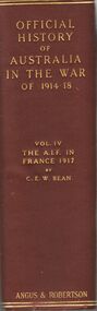
... Bean , published by Angus & Robertson 89 Castlereagh St Sydney 1939, maroon hard bound covered book with gold lettering, inside cover signed Wesley Harry 1973, 423 illustrations and maps, eighth edition (first edition was 1933)....Bean , published by Angus & Robertson 89 Castlereagh St Sydney 1939, maroon hard bound covered book with gold lettering, inside cover signed Wesley Harry 1973, 423 illustrations and maps, eighth edition (first edition was 1933). Book OFFICIAL HISTORY OF AUSTRALIA IN THE WAR OF 1914 TO 1918 ...Official History of Australia in the war of 1914-1918 Vol IV The A.I.F. in France 1917 by C.E.W. Bean , published by Angus & Robertson 89 Castlereagh St Sydney 1939, maroon hard bound covered book with gold lettering, inside cover signed Wesley Harry 1973, 423 illustrations and maps, eighth edition (first edition was 1933).C.E.W. Beanbooks, military, c e w bean / -
 Bendigo Historical Society Inc.
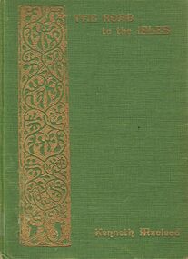
Book - ALEC H CHISHOLM COLLECTION: BOOK 'THE ROAD TO THE ISLES' BY KENNETH MACLEOD
... Published in 1933 by Grant & Murray, Edinburgh and printed in Great Britain by Turnbull & Spears. Maps...Published in 1933 by Grant & Murray, Edinburgh and printed in Great Britain by Turnbull & Spears. Maps ...Book. ALEC H CHISHOLM COLLECTION. A 248 page hardcover book of poetry, lore and tradition of the Hebrides. With an introduction by Marjory Kennedy-Fraser. Published in 1933 by Grant & Murray, Edinburgh and printed in Great Britain by Turnbull & Spears. Maps of the Isles inside front and back covers. Catalogue sticker ''2185 MAC'' on spine.Kenneth MacLeodbooks, collections, poetry, alec h chisholm collection, kenneth macleod, poetry, hebrides -
 Bendigo Historical Society Inc.
Document - MCCOLL, RANKIN AND STANISTREET COLLECTION: CENTRAL RED WHITE AND BLUE - BUNDLE OF PAPERS, 1912
... 1933, leases with mining rights, treatment of pyrites agreement 1917 - J. Edwards & Co, Helen Streader - release of liability after being paid (pounds)125 by mine due to accidental death of husband 1912. Another for Ellen Lane 1916, list of titles held by Co , lease agreements Filcock and Manning, Andrew Harkness 'winding plant at mine' 1923, notice to perform agreement to Manning's 1916, Edwards Metallurgical Works 1917, map for 9777 Bendigo, contract for explosives with Dalgety & Co 1917, new scrip for lost shares 1917, Miner's Right 1911, sale of land Ra. ...1933, leases with mining rights, treatment of pyrites agreement 1917 - J. Edwards & Co, Helen Streader - release of liability after being paid (pounds)125 by mine due to accidental death of husband 1912. Another for Ellen Lane 1916, list of titles held by Co , lease agreements Filcock and Manning, Andrew Harkness 'winding plant at mine' 1923, notice to perform agreement to Manning's 1916, Edwards Metallurgical Works 1917, map for 9777 Bendigo, contract for explosives with Dalgety & Co 1917, new scrip for lost shares 1917, Miner's Right 1911, sale of land Ra. ...Documents: Whitelaw Central Red White and Blue Mine Bendigo. 28 pages summary of gold mining correspondence - mortgage mining leases 943689340, contract of sale to Central Blue Gum GM 1933, leases with mining rights, treatment of pyrites agreement 1917 - J. Edwards & Co, Helen Streader - release of liability after being paid (pounds)125 by mine due to accidental death of husband 1912. Another for Ellen Lane 1916, list of titles held by Co , lease agreements Filcock and Manning, Andrew Harkness 'winding plant at mine' 1923, notice to perform agreement to Manning's 1916, Edwards Metallurgical Works 1917, map for 9777 Bendigo, contract for explosives with Dalgety & Co 1917, new scrip for lost shares 1917, Miner's Right 1911, sale of land Ra. A. Rankin 1910.MCCOLL RANKIN AND STANISTREETorganization, mining, central red white and blue, mccoll rankin and stanistreet. -
Bendigo Historical Society Inc.
Book - THE AUSTRALIAN BOY SCOUT DIARY 1933, 1933
... Calendars 1933, 1934. 1934 Calendar. Conventional Signs and Maps. Fires. First Aid. ...Calendars 1933 1934. 1934 Calendar. Conventional Signs and Maps. Fires. First Aid. ...The Australian Boy Scout Diary 1933. Inside front cover is an intimate picture of Chief & his family. With specially written notes and Sketches for Cubs, Scouts, Rovers and Scouters. Obtainable at all State Headquaters in Australia. Prepared and Published by the Victorian Section in conjuntion with the Federal Scout Council of Australia. Printed by Exchange Press Pty Ltd, 310 Spencer Street, Melbourne. Index: Boy Scouts. Bush Fires. Calendars 1933, 1934. 1934 Calendar. Conventional Signs and Maps. Fires. First Aid. Headquaters Address. Holidays. Knots, Bends and Hitches. List of Badges. Local Fixtures. Morse. Our Flag. Personal Memoranda. Pioneering. Plan of Camp. Rover Scouts. Scout Uniform. Scout Signs and Salutes. Sea Scouts. Sea Scouting - Notes on Boat Handling. Semaphore. South by the Stars. Swimming. Torch. Treatment of Snakebite. Troop Camps. Weights and Measures. Wolf Cubs. Wood Badge. Uses of Scout Staff. Inside rear cover is a sepia photo of the site of the 1933 Jamboree at Godollo, Hungary. Book is very detailed giving information on all aspects of Scout life, with sketches for knots, maps, etc. Inscriptions are on page 58: Troup or Pack - 1st Epsom Pack. Watch No. 4133033. Season Ticket No. Commonwealth acc 957. Savings No. 4729. Size in Hats: 7. Size of Boots: 5. Size of Collar 14 1/2. Size of Gloves 6 1/4. Iinscription on page 60: Books Read: In Search of Wales, Morton. Faraway, Priestly. Jock the Scot, Alice Grant Rosemary. Bernard Shaw, Frank Harris.Exchange Press Pty Ltd., Melbournebook, bendigo, scouts, the australian boy scout diary 1933. photo of chief & his family. notes and sketches for cubs, scouts, rovers and scouters. obtainable at all state headquarters in australia. published by the victorian section in conjunction with the federal scout council of australia. exchange press pty ltd, melbourne. index: boy scouts. bush fires. calendars 1933, 1934. 1934 calendar. conventional signs and maps. fires. first aid. headquarters address. holidays. knots, bends and hitches. list of badges. local fixtures. morse. our flag. personal memoranda. pioneering. plan of camp. rover scouts. scout uniform. scout signs and salutes. sea scouts. sea scouting - notes on boat handling. semaphore. south by the stars. swimming. torch. treatment of snakebite. troop camps. weights and measures. wolf cubs. wood badge. uses of scout staff. sepia photo of the site of the 1933 jamboree at godollo, hungary. information on all aspects of scout life, with sketches for knots, maps, etc. inscriptions page 58: troup or pack - 1st epsom pack. watch no. 4133033. season ticket no. commonwealth acc 957. savings no. 4729. size in hats: 7. size of boots: 5. size of collar 14 1/2. size of gloves 6 1/4. page 60: books read: in search of wales, morton. faraway, priestly. jock the scot, alice grant rosemary. bernard shaw, frank harris. -
 Flagstaff Hill Maritime Museum and Village
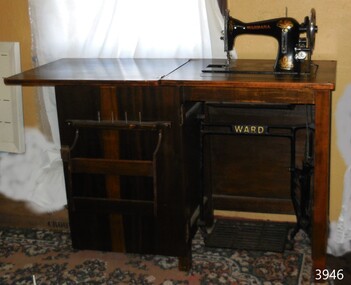
Domestic object - Sewing machine in cabinet, Ward Brothers (G & S Ward), ca. 1933
... 1933 and used it to sew garments for her sister's dressmaking business in Frankston, Victoria. The donor often used this machine until she purchased an updated model. There were originally three Ward Brothers who owned the North Melbourne sewing machine business but they had a falling out. This machine's decals on the map...1933 and used it to sew garments for her sister's dressmaking business in Frankston, Victoria. The donor often used this machine until she purchased an updated model. There were originally three Ward Brothers who owned the North Melbourne sewing machine business but they had a falling out. This machine's decals on the map ...The donor inherited this Wardana machine from her mother, who bought it in about 1933 and used it to sew garments for her sister's dressmaking business in Frankston, Victoria. The donor often used this machine until she purchased an updated model. There were originally three Ward Brothers who owned the North Melbourne sewing machine business but they had a falling out. This machine's decals on the map of Australia only include the two remaining brothers. The Ward Brothers, G & S Ward, established their sewing machine business in North Melbourne in 1888. The cabinets and ironwork of the machines were made in Australia and the Ward Bros. imported their machines from overseas manufacturers in England, America and Germany. The assembled machines were sold under brand names that included Ward, A.N.A. the patriotic-sounding Australian Sewing Machine Company. The "Wardana" was one of their brands.This sewing machine was fabricated in Australia from imported parts from England, giving a snapshot into the early manufacturing industries that were operating at the time just after Federation.Sewing machine in a wooden cabinet with iron foot-operated cast iron treadle mechanism. The hinged cabinet top opens out to form a worktop. The sewing machine lifts out of the cabinet to sit level with the worktop, resting on two supports within the cabinet. The lockable cabinet door opens from right to left revealing fitted shelves and spikes for spools and bobbins. The gold-painted maker's name is cast into the black treadle. The machine has its original instruction book, oil can, and eighteen accessories in an enclosed cardboard box. The round shallow oil bottle has a rubber dispensing tube. Colourful decals decorate the black body of the machine. Inscriptions include a Serial Number stamped on the bed of the machine. The Wardarna Central Bobbin machine was made in England for the Ward Brothers of North Melbourne.TREADLE: cast into metal ACROSS THE TOPE AND ON THE FOOTPLATE "WARD", "WARD" SERIAL NUMBER stamped into oval plate "28383" DECAL: (Map of Australia ) with images of [two brothers] , "WARDANA" above (logo of the rising sun) DECAL: (Decorative floral design with heraldic-like emblems) above "MADE IN ENGLAND" ARM: "WARDANA" PEDESTAL: "C.B." (representing Central Bobbin) "MADE IN ENGLAND" "MADE IN ENGLAND / FOR / WARD BROS / NORTH MELBOURNE" BOOK TITLE: "Instructions for Treadle Machine" ACCESSORIES: some have indecipherable embossed stamps OIL BOTTLE base: (image of log and short lines radiating from a central inscription (indecipherable)sewing machine, domestic, wardana, ward bros., central bobbin, made in england, north melbourne, c.b., flagstaff hill, warrnambool, shipwrecked coast, flagstaff hill maritime museum, maritime museum, shipwreck coast, flagstaff hill maritime village, great ocean road, treadle sewing machine, home industry, clothing, dressmaking, clothing manufacturer -
 Ringwood and District Historical Society
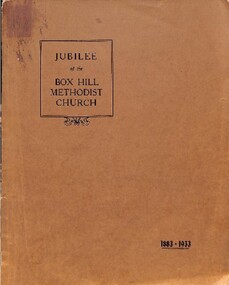
Book, Jubilee of the Box Hill Methodist Church 1883-1933
... The Beginning - Trustees and Church Debts and Buildings The Depression and Church Union - The Curch Leads the Way Temperance The Sunday School The Ministers Local Preachers Organ and Choir Cheer-Up Brigade Progress and Change Foreign Missions Hospital Sunday Pew Rents Making Records Class Meeting and Endeavour Sport The Ladies Conclusion Tables Index Maps Brown soft covered book with diagrams maps and photographs compiling information supplied or made available to the editors of the "Spectator", "Reporter" and "Woman's World" by Ministers and Officers of the churches at Richmond, Hawthorn and Auburn, Mr. R.A. Sutton, Mrs. A. Edgoose and Mr. J.R. Ellingworth and others who have helped with their memories of the past. Jubilee of the Box Hill Methodist Church 1883-1933 ...Brown soft covered book with diagrams maps and photographs compiling information supplied or made available to the editors of the "Spectator", "Reporter" and "Woman's World" by Ministers and Officers of the churches at Richmond, Hawthorn and Auburn, Mr. R.A. Sutton, Mrs. A. Edgoose and Mr. J.R. Ellingworth and others who have helped with their memories of the past.Wholly set up and printeed in Australia by Reporter Print, Box Hill, 1937. CONTENTS. The Beginning - Trustees and Church Debts and Buildings The Depression and Church Union - The Curch Leads the Way Temperance The Sunday School The Ministers Local Preachers Organ and Choir Cheer-Up Brigade Progress and Change Foreign Missions Hospital Sunday Pew Rents Making Records Class Meeting and Endeavour Sport The Ladies Conclusion Tables Index Maps -
 Federation University Historical Collection
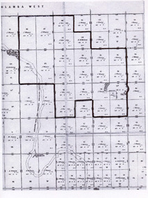
Map, Ballarat, 1936, 06/1936
... Map of Ballarat and surrounds, including Lake Learmonth, Snake Valley, Linton, Newton, Durham Lead, Sebastopol, Lake Wendouree, Winter Swamo. It was surveyed in 1933...Barker Library (top floor) Mount Helen goldfields ballarat map Map of Ballarat and surrounds, including Lake Learmonth, Snake Valley, Linton, Newton, Durham Lead, Sebastopol, Lake Wendouree, Winter Swamo. It was surveyed in 1933 ...Map of Ballarat and surrounds, including Lake Learmonth, Snake Valley, Linton, Newton, Durham Lead, Sebastopol, Lake Wendouree, Winter Swamo. It was surveyed in 1933.ballarat, map -
 Federation University Historical Collection
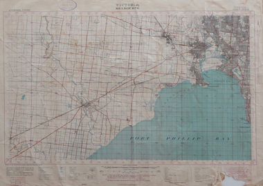
Map, Melbourne, Victoria, 1933
... Melbourne, Victoria, 1933 Map Map ...Printed colour map.melbourne, port phillip bay, werribee river, werribee, port melbourne, hobson's bay -
 Victorian Railway History Library
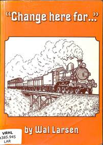
Book, Larsen, Wal, Change here for
... Victorian Railway History Library 39 St Edmonds Rd Prahran Prahran Railroads - Victorian Railways - personal reminiscence Railroad branch lines - Victoria - history Personal reminiscences from Wal Larsen on travelling on various branch line railways in Victoria in 1933-34. ill, maps, p.93. Change here for... Book Larsen, Wal Brown Pryor Anderson Pty Ltd ...Personal reminiscences from Wal Larsen on travelling on various branch line railways in Victoria in 1933-34.ill, maps, p.93.non-fictionPersonal reminiscences from Wal Larsen on travelling on various branch line railways in Victoria in 1933-34.railroads - victorian railways - personal reminiscence, railroad branch lines - victoria - history -
 Sunshine and District Historical Society Incorporated
Plan - H.V. McKay Massey Harris & Massey Ferguson Maps
... McKay Massey Harris Maps Site Plan 1933 3152.04 - H.V. McKay Massey Harris Maps 1924 Site Plan 3152.05 - H.V. ...McKay Massey Harris Maps Site Plan 1933 3152.04 - H.V. McKay Massey Harris Maps 1924 Site Plan 3152.05 - H.V. ...3152.01 - H.V. McKay Massey Harris Maps 1922 Site Plan 3152.02 - H.V. McKay Massey Harris Maps Factory Gas And Water Plants 1941 3152.03 - H.V. McKay Massey Harris Maps Site Plan 1933 3152.04 - H.V. McKay Massey Harris Maps 1924 Site Plan 3152.05 - H.V. McKay Massey Harris Maps 1927 Site Plan 3152.06 - H.V. McKay Massey Harris Maps 1956 Type Of Buildings Site Plan 3152.07 - H.V. McKay Massey Harris Maps 1986 Restricted Area Construction Plan 3152.08 - H.V. McKay Massey Harris Maps Factory Gas And Water Control Plan 1941 3152.09 - H.V. McKay Massey Harris Maps Aerial Photoh.v. mckays massey ferguson, sunshine harvester works -
 Bendigo Regional Archives Centre
Book (item) - Mahlstedt's Pty Ltd Consulting Fire Engineers & Survey. Fire Insurance Survey plans of Geelong, Ballarat and Bendigo ca 1933, ca1933
... Mahlstet's (Vic) Pty Ltd Hardcover binder with screw pins 70cm x 52cm x 5cm with hand-drawn maps of Geelong, Ballarat and Bendigo CBD Survey plans Mahlstedt's Pty Ltd Consulting Fire Engineers & Survey. Fire Insurance Survey plans of Geelong, Ballarat and Bendigo ca 1933 Book Mahlstedt's Pty Ltd Consulting Fire Engineers & Survey. ...Mahlstet's (Vic) Pty Ltd -
 Tatura Irrigation & Wartime Camps Museum
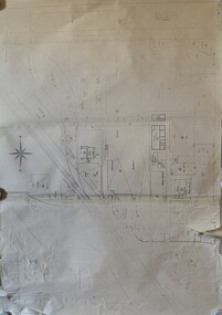
Map, Part Murchison North Parish Plan
... 1933, owned by Gerald N. Buckley, purchased in 1936 by Pargeter, and held until 1943. Note that Kiota Road west of the Tatura Murchison Road was unfenced in those years. Kiota Estate, Pargester,Buckley, Dhurringile. Part Murchison North Parish Plan Map ...Ownership detail obtained from S.R. & W.S.C. rate book 1933. Part Murchison North Parish Plan with extent of "Kiota" property outlined, as in 1933, owned by Gerald N. Buckley, purchased in 1936 by Pargeter, and held until 1943. Note that Kiota Road west of the Tatura Murchison Road was unfenced in those years.kiota estate, pargester,buckley, dhurringile. -
 Uniting Church Archives - Synod of Victoria
Photograph, Rev. Benjamin Danks, 19th C
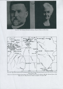
... 1933); Neville Threlfall, One Hundred Years in the Islands (Rabaul, 1975). MICHAEL HORSBURGH Electronic Version © Southern Cross College, 2004. Content © Evangelical History Association of Australia and the author, 2004. danks, benjamin new britain Photocopy of page from a book (A4 size) with pictures of Danks and Mrs. Danks and a map ...Benjamin Danks was b. 1853 England, ordained 1878, and died 1921 in Rookwood, NSW. DANKS, Benjamin (1853-1921) Michael Horsburgh, DANKS, BENJAMIN (b. Wednesbury, England, 12 Feb 1853; d. Sydney, NSW, 12 April 1921). Methodist missionary in New Britain and missionary administrator. Benjamin Danks migrated to Vic with his family when a young child. He entered the Wesleyan Methodist ministry in 1878 and was sent with his wife, Emma, daughter of John and Elizabeth Watsford, to join the Rev George Brown in the newly established missionary venture on the Duke of York group in New Britain, where he remained for nine years. An opponent of 'blackbirding', the traffic in indentured island labour for the Australian sugar cane industry, he warned local inhabitants not to go aboard any vessel recruiting labour for distant places, much to the displeasure of the labour traders. In 1880 he participated in the rescue of the survivors of the ill-fated settlement established by the Marquis de Rays. In 1907 he succeeded George Brown as the general secretary of Foreign Missions for the Methodist Church of Australasia and was president of the NSW Conference in 1908. He retired in 1918 and died in 1921 after a long illness attributed to the privations of his missionary career. Danks was highly regarded as a linguist and published the first book in the Tolai language of New Britain. He was a strong supporter of state legislation to control social evils, and to ensure pure food and drugs. He was an ardent temperance advocate. George Brown, An Autobiography (London, 1908); New South Wales Methodist Conference, Souvenir of the Presidency of the Rev. Benjamin Danks (Sydney, 1909); Wallace Deane (ed), In Wild New Britain (Sydney, 1933); Neville Threlfall, One Hundred Years in the Islands (Rabaul, 1975). MICHAEL HORSBURGH Electronic Version © Southern Cross College, 2004. Content © Evangelical History Association of Australia and the author, 2004.Photocopy of page from a book (A4 size) with pictures of Danks and Mrs. Danks and a map showing New Britain and New Ireland and the mission stations of the New Britain district of the Wesleyan Methodist Mission and the sites of the Free Colony of New France.danks, benjamin, new britain -
Victorian Aboriginal Corporation for Languages
Book, Chris Illert, Early ancestors of Illawarra's Wadi-Wadi people. Part 1., The unacknowledged sources of traditional stories in C. W. Peck's book 'Australian legends, tales handed down from the remotest times--' (publ. 1925 and 1933), 2003
... Maps, b&w photographs, b&w illustrations, word lists, newspaper articles Includes stories about people and the languages, word lists,pronunciation and sources of stories. Early ancestors of Illawarra's Wadi-Wadi people. Part 1., The unacknowledged sources of traditional stories in C. W. Peck's book 'Australian legends, tales handed down from the remotest times--' (publ. 1925 and 1933 ...Includes stories about people and the languages, word lists,pronunciation and sources of stories.Maps, b&w photographs, b&w illustrations, word lists, newspaper articleswadi wadi, wulungulu, gundungara, korewal, south coast nsw, cooma -
 Vision Australia
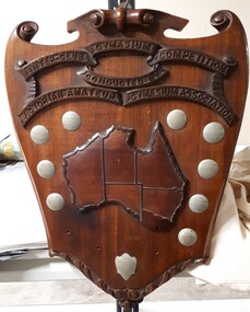
Photograph - Image, Inter-Club Gymnasium Competition
... 1933-34 Won by "Trojans" B.P.C.C. V.A.G.A. Inter-club gym contest 1935 Won by V.R.I. Gym Club Won by "Trojans" 1936 Won by "Trojans" 1937 Runners Up Bonbeach 1934 Runners Up Trojans 1935 Runners Up "Achilles" 1936 Runners Up "Achilles" 1937 Achilles Runners Up 1938 Presented by W.T. Conder recreation royal victorian institute for the blind awards Inter-Club Gymnasium Competition conducted by Victorian Amateur Gymnasium Association Image of wooden shield with metal plaques and map ...The Conder Shield was sponsored by Major Wally Conder, a keen sportsman (amongst other occupations,) who sought to promote wrestling and boxing during his time as president of the Victorian Amateur Wrestling and Boxing Association. Presented to the winning club of the Inter-Club Gymnasium Competition, over a series of matches in individual athleticism. These included skipping, roller cycling and chinning bar, as well as light-weight, middle-weight and welter-weight wrestling. The clubs that vied for this shield were the Trojans (from the RVIB), Bonbeach Surf and Life Saving Club and Beattie's Physical Culture School. In 1934, the Trojans team consisted of Neil Westh, Charlie Bradley, A. McDonald, T. Hanlon, B. Cook and coach/captain V. Blucher. Mr Henry Vincent Blucher was a former police constable to lost his sight in 1931 due to a car accident, and who had previously held the title of Victorian novice middleweight. Metal plates on shield read: V.A.G.A. Inter-club gym contest 1933-34 Won by "Trojans" B.P.C.C. V.A.G.A. Inter-club gym contest 1935 Won by V.R.I. Gym Club Won by "Trojans" 1936 Won by "Trojans" 1937 Runners Up Bonbeach 1934 Runners Up Trojans 1935 Runners Up "Achilles" 1936 Runners Up "Achilles" 1937 Achilles Runners Up 1938 Presented by W.T. ConderImage of wooden shield with metal plaques and map of AustraliaInter-Club Gymnasium Competition conducted by Victorian Amateur Gymnasium Associationrecreation, royal victorian institute for the blind, awards -
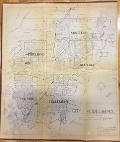 Kew Historical Society Inc
Plan, City Engineers Department (Heidelberg), City of Heidelberg Plan: Scale 20 chns to 1 inch, 1970-1993
... 1933- ). Gwen McWilliam is well known as an authority on the history of Boroondara and the author of a large number of books and pamphlets about the City. She was awarded the medal of the Order of Australia in 2001 ‘for service to the community of Hawthorn and district, particularly through the research, documentation and publication of its history.’ Primary source annotated by a distinguished local historian. city of heidelberg maps ...Gwen Barton McWilliam (nee: Nelson), OAM, BA (1933- ). Gwen McWilliam is well known as an authority on the history of Boroondara and the author of a large number of books and pamphlets about the City. She was awarded the medal of the Order of Australia in 2001 ‘for service to the community of Hawthorn and district, particularly through the research, documentation and publication of its history.’ Primary source annotated by a distinguished local historian.Plan of number of areas in the City of Heidelberg showing municipal and ward boundaries, subsequently annotated by the historian Gwen McWilliam, identifying significant landholdings, subdivisions and key dates.The base map was printed in 1970 and annotated c.1993. The plan was donated to the Kew Historical Society by Gwen McWilliam. Handwritten annotations by Gwen McWilliam, 1993city of heidelberg, maps -- heidelberg (vic.), gwen mcwilliam