Showing 40 items matching "1980 floods"
-
 Charlton Golden Grains Museum Inc
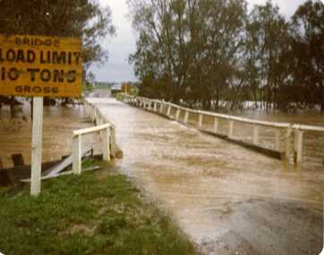
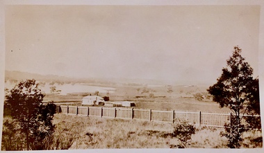
Photograph, Charlton Floods - 7 Mile Lane Bridge over Avoca River- Approx 1980 - Charlton South Vic. 35258
... 1980 Floods...1980 Floods 7 Mile Lane Bridge Avoca River 7 Mile Lane Bridge over Avoca River Charlton Floods - 7 Mile Lane Bridge over Avoca River- Approx 1980 - Charlton South Vic. 35258 Photograph ...7 Mile Lane Bridge over Avoca River1980 floods, 7 mile lane bridge, avoca river -
 Melbourne Tram Museum
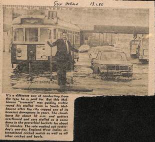
Newspaper, Herald Sun, Newspaper clipping re flooding in South Melbourne, 13-1-1980
... Newspaper cutting from the Herald Sun 13-1-1980 about flooding in South Melbourne and delaying tram W7 1019...Yields information about the type of delays that can occur on a big tram system. trams tramways tramcars flooding floods South Melbourne W7 1019 Route 10 crews "Sun Herald 13.1.80" Newspaper cutting from the Herald Sun 13-1-1980 about flooding in South Melbourne and delaying tram W7 1019 Newspaper clipping re flooding in South Melbourne Newspaper Vic Melbourne Herald Sun ...Newspaper cutting about flooding in South Melbourne disabling a tram and a "trammie" conductor or driver, directing traffic. Tram W7 1019, route 10.Yields information about the type of delays that can occur on a big tram system.Newspaper cutting from the Herald Sun 13-1-1980 about flooding in South Melbourne and delaying tram W7 1019"Sun Herald 13.1.80"trams, tramways, tramcars, flooding, floods, south melbourne, w7 1019, route 10, crews -
 Kiewa Valley Historical Society
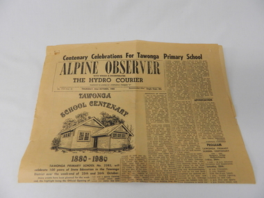
Newspaper Article - Tawonga School Centenary 1980 x2, Alpine Courier incorporating The Hydro Courier, 1980
... flooded Kiewa river. The article also covers the changes brought about by the increased employment opportunities from SEC Kiewa Works(1935), the Sawmill(1946), the Gold mine(1949) and the Tobacco Industry (largest growing area in Australia). rural school development tawonga school centenary kiewa valley development 1880 to 1980 "Centenary Celebrations For Tawonga Primary School" below this in an enclosed heading "ALPINE OBSERVER" underneath in smaller print "WITH WHICH IS INCORPORATED" below this in larger print "THE HYDRO COURIER" and below this from left to right, "No. 719 (Vol. 3) THURSDAY, 23rd OCTOBER, 1980" next "in smaller print Recommended Price Single Copy, 20c "(cents) This item is a one page (original) article of the centenary celebrations for Tawonga Primary School came from the Alpine Observer and incorporated the Hydro Courier. ...This newspaper article was produced at a time when newspapers were the main source of local information. The period before the explosion of mobile communication technology and the cost effectiveness of communication by "texting" and internet "social connections, eg. facebook and other social media networkings" The newspapers were the main links between and within large regions. The Hydro Courier was first printed in 1950 as a YMCA community service publication by Mr. Albert Clarke YMCA Officer and Mr. Alex McCullough a State Electricity Commission employee. This paper was one very important publication that provided relevant community information to all and was the major contributer to the "Valley" cohesive fibre and unity. This article not only records the celebration (centenary) of the Tawonga School but also presents the history of the school and important events such as various relocations of classrooms and how the region was settled and developed from the 1870's onward. The yawonga school opened in 1880 on 8 acres of land. It consisted of one large wooden building (22 ft x 11 ft). It had two windows, one brick chimney, bare wooden floor and a shingle roof. This article also presents the time when Mount Beauty area was likened to an island and occasionally school children could not attend school because of a flooded Kiewa river. The article also covers the changes brought about by the increased employment opportunities from SEC Kiewa Works(1935), the Sawmill(1946), the Gold mine(1949) and the Tobacco Industry (largest growing area in Australia).This item is a one page (original) article of the centenary celebrations for Tawonga Primary School came from the Alpine Observer and incorporated the Hydro Courier. It covers the arrangements for the celebration of the 100 years of the school's existence. The printed layout is typical of the typeset in use in 1980's. There are seven distinctive type collumns separated by a printed line. Three photographs are published with one photograph of a demountable classromm ,circa 1980, and the other two of student class photos of 1899 and 1914. Teacher and student names are listed below each photograph. On the back of this page are "specials" for "Sam's Cut Price Stores", specifically the Myrtleford store. Of interest is the advertisement of "Cartons of Cigarettes at cut prices". The page was produced as part of a "run" with "telltale" holes at each corner for stabilising the page in the printing process."Centenary Celebrations For Tawonga Primary School" below this in an enclosed heading "ALPINE OBSERVER" underneath in smaller print "WITH WHICH IS INCORPORATED" below this in larger print "THE HYDRO COURIER" and below this from left to right, "No. 719 (Vol. 3) THURSDAY, 23rd OCTOBER, 1980" next "in smaller print Recommended Price Single Copy, 20c "(cents)rural school development, tawonga school centenary, kiewa valley development 1880 to 1980 -
 Eltham District Historical Society Inc
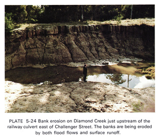
Work on paper (Sub-Item) - Photograph, Bank erosion on Diamond Creek just upstream of the railway culvert east of Challenger Street
... The banks are eroded by both flood flows and surface runoff eltham drain diamond creek erosion Challenger Street Image printed on A4 page from 04997 Diamond Creek Basin Study, 1980 Bank erosion on Diamond Creek just upstream of the railway culvert east of Challenger Street Work on paper Photograph ...Colour photograph of bank erosion on Diamond Creek just upstream of the railway culvert east of Challenger Street in Diamond Creek township. The banks are eroded by both flood flows and surface runoffeltham, drain, diamond creek, erosion, challenger street -
 Eltham District Historical Society Inc
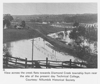
Work on paper (Sub-Item) - Photograph, View across the creek flats towards Diamond Creek township
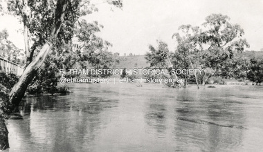
... Nillumbik Historical Society collection flood Diamond Creek Nillumbik Historical Society Image printed on A4 page from 04997 Diamond Creek Basin Study, 1980 View across the creek flats towards Diamond Creek township Work on paper Photograph ...Undated black and white photograph of view across the creek flats towards Diamond Creek township showing the railway line, with the Diamond Creek under flood. Situated behind the vicinity of Diamond Valley College, Main Hurstbridge Road, Diamond Creek. Diamond Valley College was formed in 1989 from the almagamation of Diamond Creek Technical School and Hurstbridge High School. Nillumbik Historical Society collectionflood, diamond creek, nillumbik historical society -
 Eltham District Historical Society Inc
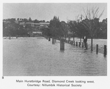
Work on paper (Sub-Item) - Photograph, Main Hurstbridge Road, Diamond Creek looking west
... Nillumbik Historical Society collection flood diamond creek Nillumbik Historical Society Image printed on A4 page from 04997 Diamond Creek Basin Study, 1980 Main Hurstbridge Road, Diamond Creek looking west Work on paper Photograph ...Undated black and white photograph of Main Hurstbridge Road, Diamond Creek in flood looking west. Nillumbik Historical Society collectionflood, diamond creek, nillumbik historical society -
 Eltham District Historical Society Inc
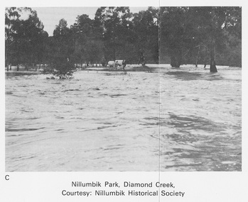
Work on paper (Sub-Item) - Photograph, Nillumbik Park, Diamond Creek
... Nillumbik Historical Society collection flood diamond creek Nillumbik Historical Society Image printed on A4 page from 04997 Diamond Creek Basin Study, 1980 Nillumbik Park, Diamond Creek Work on paper Photograph ...Undated black and white photograph of the Diamond Creek in flood, Nillumbik Park, Diamond Creek. Cattle take refuge on a high point. Nillumbik Historical Society collectionflood, diamond creek, nillumbik historical society -
 Eltham District Historical Society Inc
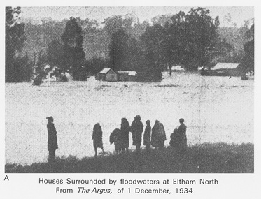
Work on paper (Sub-Item) - Photograph, Houses surrounded by floodwaters at Eltham North
... In 1934 extensive flooding of the Yarra River and Diamond Creek sets new records for flood plain level (via Chronology of Eltham, EDHS) flood frizell leads argus glen park eltham north flooding marooned diamond creek Image printed on A4 page from 04997 Diamond Creek Basin Study, 1980 Houses surrounded by floodwaters at Eltham North Work on paper Photograph ..."The house (centre) at North Eltham in which Mr. and Mrs. William Frizell, an elderly couple, were marooned by flood waters. When this photograph was taken late yesterday afternoon the couple were still inside the house, and through a ventilator they had stuck a red flag which they waved from time to time. The house on the left belongs to Mr. Leads, who also was marooned." - The Argus 1 December 1934. John William Frizell, painter and his wife Sarah Jane are registered at Glen Park, Eltham in the 1924 Electorial Roll This was most probably the Diamond Creek in flood. In 1934 extensive flooding of the Yarra River and Diamond Creek sets new records for flood plain level (via Chronology of Eltham, EDHS) flood, frizell, leads, argus, glen park, eltham north, flooding, marooned, diamond creek -
 Eltham District Historical Society Inc
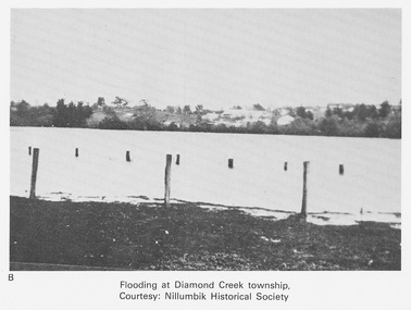
Work on paper (Sub-Item) - Photograph, Flooding at Diamond Creek Township
... In 1934 extensive flooding of the Yarra River and Diamond Creek set new records for flood plain level (Eltham Chronology EDHS) Nillumbik Historical Society collection flood diamond creek flooding Nillumbik Historical Society Image printed on A4 page from 04997 Diamond Creek Basin Study, 1980 Flooding at Diamond Creek Township Work on paper Photograph ...Black and white photograph of the Diamond Creek in flood at Diamond Creek township in 1934. In 1934 extensive flooding of the Yarra River and Diamond Creek set new records for flood plain level (Eltham Chronology EDHS) Nillumbik Historical Society collectionflood, diamond creek, flooding, nillumbik historical society -
 Eltham District Historical Society Inc
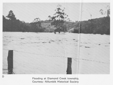
Work on paper (Sub-Item) - Photograph, Flooding at Diamond Creek Township
... In 1934 extensive flooding of the Yarra River and Diamond Creek set new records for flood plain level (Eltham Chronology EDHS) Nillumbik Historical Society collection flood diamond creek flooding Nillumbik Historical Society Image printed on A4 page from 04997 Diamond Creek Basin Study, 1980 Flooding at Diamond Creek Township Work on paper Photograph ...Black and white photograph of the Diamond Creek in flood at Diamond Creek township in 1934. In 1934 extensive flooding of the Yarra River and Diamond Creek set new records for flood plain level (Eltham Chronology EDHS) Nillumbik Historical Society collectionflood, diamond creek, flooding, nillumbik historical society -
 Eltham District Historical Society Inc
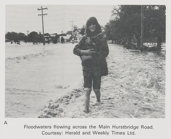
Work on paper (Sub-Item) - Photograph, Floodwaters flowing across Main Hurstbridge Road, Diamond Creek Township, 8 April 1977
... The Diamond Creek in flood at Diamond Creek township, 8 April 1977 Herald and Weekly Times collection flood diamond creek flooding herald and weekly times rescue Image printed on A4 page from 04997 Diamond Creek Basin Study, 1980 Floodwaters flowing across Main Hurstbridge Road, Diamond Creek Township, 8 April 1977 Work on paper Photograph ...Black and white photograph of young woman walking through floodwaters, possibly carrying an animal. The Diamond Creek in flood at Diamond Creek township, 8 April 1977 Herald and Weekly Times collectionflood, diamond creek, flooding, herald and weekly times, rescue -
 Eltham District Historical Society Inc
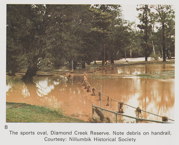
Work on paper (Sub-Item) - Photograph, The Sports Oval, Diamond Creek Reserve, Diamond Creek Township, 8 April 1977
... The Diamond Creek in flood at Diamond Creek township, 8 April 1977 Nillumbik Historical Society collection flood diamond creek flooding oval Nillumbik Historical Society rail Image printed on A4 page from 04997 Diamond Creek Basin Study, 1980 The Sports Oval, Diamond Creek Reserve, Diamond Creek Township, 8 April 1977 Work on paper Photograph ...Colour photograph. Note debris on the rail fencing around the oval. The Diamond Creek in flood at Diamond Creek township, 8 April 1977 Nillumbik Historical Society collectionflood, diamond creek, flooding, oval, nillumbik historical society, rail -
 Eltham District Historical Society Inc
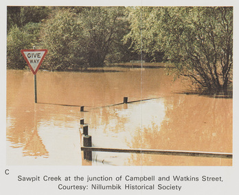
Work on paper (Sub-Item) - Photograph, Sawpit Creek at the junction of Campbell and Watkins Street, Diamond Creek Township, 8 April 1977
... The Diamond Creek in flood at Diamond Creek township, 8 April 1977 Nillumbik Historical Society collection flood diamond creek flooding nillumbik historical society give way Sawpit Creek Campbell Street Watkins Street Image printed on A4 page from 04997 Diamond Creek Basin Study, 1980 Sawpit Creek at the junction of Campbell and Watkins Street, Diamond Creek Township, 8 April 1977 Work on paper Photograph ...Colour photograph. Sawpit Creek at the junction of Campbell and Watkins Street, Diamond Creek Township. The Diamond Creek in flood at Diamond Creek township, 8 April 1977 Nillumbik Historical Society collectionflood, diamond creek, flooding, nillumbik historical society, give way, sawpit creek, campbell street, watkins street -
 Eltham District Historical Society Inc
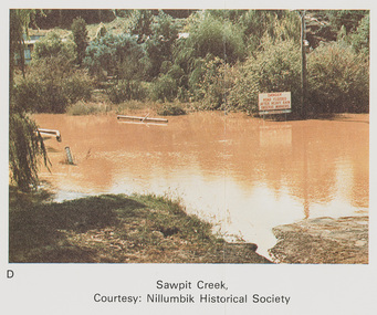
Work on paper (Sub-Item) - Photograph, Sawpit Creek in flood, Diamond Creek Township, 8 April 1977
... Sawpit Creek near the Diamond Creek in flood at Diamond Creek township, 8 April 1977 A road sign reads" DANGER ROAD FLOODED AFTER HEAVY RAIN OBSERVE MARKERS" Nillumbik Historical Society collection flood diamond creek flooding nillumbik historical society give way sawpit creek campbell street watkins street Danger road sign Image printed on A4 page from 04997 Diamond Creek Basin Study, 1980 Sawpit Creek in flood, Diamond Creek Township, 8 April 1977 Work on paper Photograph ...Colour photograph. Sawpit Creek near the Diamond Creek in flood at Diamond Creek township, 8 April 1977 A road sign reads" DANGER ROAD FLOODED AFTER HEAVY RAIN OBSERVE MARKERS" Nillumbik Historical Society collectionflood, diamond creek, flooding, nillumbik historical society, give way, sawpit creek, campbell street, watkins street, danger, road sign -
 Eltham District Historical Society Inc
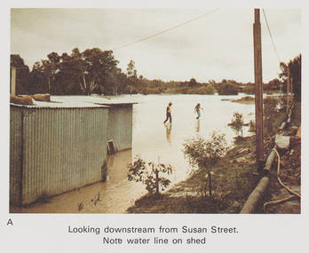
Work on paper (Sub-Item) - Photograph, Flooding, looking downstream from Susan Street, Eltham 8 April 1977
... Note water line on shed flood diamond creek flooding Susan Street Image printed on A4 page from 04997 Diamond Creek Basin Study, 1980 Flooding, looking downstream from Susan Street, Eltham 8 April 1977 Work on paper Photograph ...Colour photograph. Looking downstream from Susan Street, Eltham , 8 April 1977. Note water line on shed flood, diamond creek, flooding, susan street -
 Eltham District Historical Society Inc
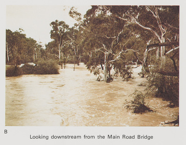
Work on paper (Sub-Item) - Photograph, Flooding, looking downstream from Main Road Bridge, Eltham 8 April 1977
... Looking downstream on the Diamond Creek from Main Road Bridge, Eltham , 8 April 1977. flood diamond creek flooding Main road Eltham Image printed on A4 page from 04997 Diamond Creek Basin Study, 1980 Flooding, looking downstream from Main Road Bridge, Eltham 8 April 1977 Work on paper Photograph ...Colour photograph. Looking downstream on the Diamond Creek from Main Road Bridge, Eltham , 8 April 1977. flood, diamond creek, flooding, main road, eltham -
 Eltham District Historical Society Inc
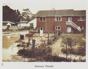
Work on paper (Sub-Item) - Photograph, Flooding, 75 Railway Parade, Eltham 8 April 1977
... Flooding of Diamond Creek at the rear and side of property at 75 Railway Parade, Eltham , 8 April 1977. flood diamond creek flooding eltham 75 Railway Parade Image printed on A4 page from 04997 Diamond Creek Basin Study, 1980 Flooding, 75 Railway Parade, Eltham 8 April 1977 Work on paper Photograph ...Colour photograph. Flooding of Diamond Creek at the rear and side of property at 75 Railway Parade, Eltham , 8 April 1977. flood, diamond creek, flooding, eltham, 75 railway parade -
 Eltham District Historical Society Inc
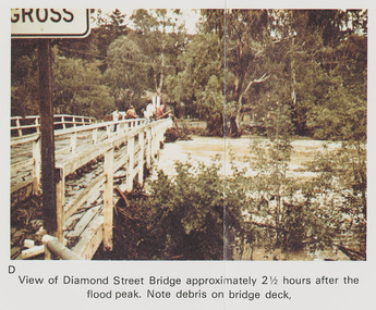
Work on paper (Sub-Item) - Photograph, Flooding, View of Diamond Street Bridge, Eltham 8 April 1977
... Note debris on the bridge deck. 8 April 1977. flood diamond creek flooding eltham Diamond Street bridge Image printed on A4 page from 04997 Diamond Creek Basin Study, 1980 Flooding, View of Diamond Street Bridge, Eltham 8 April 1977 Work on paper Photograph ...Colour photograph. Flooding of Diamond Creek at Diamond Street Eltham bridge approximately 2 1/2 hours after the flood peak. Note debris on the bridge deck. 8 April 1977. flood, diamond creek, flooding, eltham, diamond street, bridge -
 Eltham District Historical Society Inc
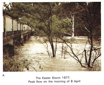
Work on paper (Sub-Item) - Photograph, Main Road Bridge, Eltham peak flow of flood 8 April, 1977
... Easter storm, 8 April, 1977 flood diamond creek flooding eltham bridge main road Image printed on A4 page from 04997 Diamond Creek Basin Study, 1980 Main Road Bridge, Eltham peak flow of flood 8 April, 1977 Work on paper Photograph ...Colour photograph. Flooding of Diamond Creek at Main Road Bridge, Eltham peak flow of flood. Easter storm, 8 April, 1977flood, diamond creek, flooding, eltham, bridge, main road -
 Eltham District Historical Society Inc
Photograph, 1934 Floods at Eltham
... 1980 and identified at Diamond Creek, locality not identified, 1934. The location is actually looking south across the Diamond Creek towards Falkiner Street, beside the Main Road bridge at Eltham South from what is now part of Wingrove Park opposite Antoinette Boulevard. The bridge railing is just visible to the left of image. The large leaning Manna Gum beside the bridge still stands in 2021 alongside the Diamond Creek trail. In 1934 extensive flooding...1980 and identified at Diamond Creek, locality not identified, 1934. The location is actually looking south across the Diamond Creek towards Falkiner Street, beside the Main Road bridge at Eltham South from what is now part of Wingrove Park opposite Antoinette Boulevard. The bridge railing is just visible to the left of image. The large leaning Manna Gum beside the bridge still stands in 2021 alongside the Diamond Creek trail. In 1934 extensive flooding ...Published in the Diamond Creek Basin Study, 1980 and identified at Diamond Creek, locality not identified, 1934. The location is actually looking south across the Diamond Creek towards Falkiner Street, beside the Main Road bridge at Eltham South from what is now part of Wingrove Park opposite Antoinette Boulevard. The bridge railing is just visible to the left of image. The large leaning Manna Gum beside the bridge still stands in 2021 alongside the Diamond Creek trail. In 1934 extensive flooding of the Yarra River and Diamond Creek set new records for flood plain level (Eltham Chronology, EDHS)Black and white photographCopied by Hugh Fisher, Photographer, 6 York Street Eltham A1678B Floods- Eltham - 1934floods, yarra river, eltham, flooding, diamond creek, flood -
 Bendigo Historical Society Inc.
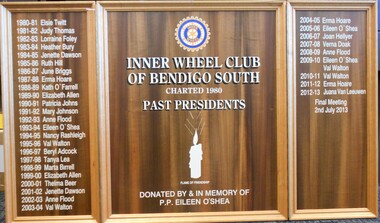
Memorabilia - INNER WHEEL CLUB SOUTH BENDIGO COLLECTION: HONOUR ROLL
... On centre panel: ' Inner Wheel Club of South Bendigo, Chartered 1980, Past Presidents, Donated by and in memory of P.P Eileen O'Shea' Names on board either side of centre panel: 1980-81 Elsie Twitt 1982-83 Judy Thomas 1982-83 Lorraine Foley 1983-84 Heather Bury 1984-85 Jenette Dawson 1985-86 Ruth Hill 1986-87 June Briggs 1987-88 Erma Hoare 1988-89 Kath O'Farrell 1989-90 Elizabeth Allen 1990-91 Patricia Johns 1991-92 Mary Johnson 1992-93 Anne Flood 1993-94 Eileen O'Shea 1994-95 Nancy Rashleigh 1995-96 Val Walton 1996-97 Beryl Adcock 1997-98 Tanya Lea 1998-99 Marta Birrell 1999-00 Elizaabeth Allen 2000-01 Thelma B eer 2002-02 lJenette Dawson 2002-03 Anne Flood 2003-04 Val Walton 2004-05 Erma Hoare 2005-06 Eileen O'Shea 2006-07 Joan Hellyer 2007-08 Verna Doak 2008-09 Anne Flood 2009-10 Eileen O'Shea and Val Walton 2020-11 Val Walton 2022-12 Juana Van Leeuwen Final Meeting 2nd July, 2013....On centre panel: ' Inner Wheel Club of South Bendigo, Chartered 1980, Past Presidents, Donated by and in memory of P.P Eileen O'Shea' Names on board either side of centre panel: 1980-81 Elsie Twitt 1982-83 Judy Thomas 1982-83 Lorraine Foley 1983-84 Heather Bury 1984-85 Jenette Dawson 1985-86 Ruth Hill 1986-87 June Briggs 1987-88 Erma Hoare 1988-89 Kath O'Farrell 1989-90 Elizabeth Allen 1990-91 Patricia Johns 1991-92 Mary Johnson 1992-93 Anne Flood 1993-94 Eileen O'Shea 1994-95 Nancy Rashleigh 1995-96 Val Walton 1996-97 Beryl Adcock 1997-98 Tanya Lea 1998-99 Marta Birrell 1999-00 Elizaabeth Allen 2000-01 Thelma B eer 2002-02 lJenette Dawson 2002-03 Anne Flood 2003-04 Val Walton 2004-05 Erma Hoare 2005-06 Eileen O'Shea 2006-07 Joan Hellyer 2007-08 Verna Doak 2008-09 Anne Flood 2009-10 Eileen O'Shea and Val Walton 2020-11 Val Walton 2022-12 Juana Van Leeuwen Final Meeting 2nd July, 2013. ...Inner Wheel was established in 1924, initially for the wives of Rotary Club members. The first Victorian club was established in Ballarat in 1931 closely followed by Bendigo in 1933. The South Bendigo Club formed in 1980 and is one of over 700 clubs in Australia.Wooden, tri-foldout honour roll of Inner Wheel Club, Bendigo South. . Names of Past Presidents inscribed in white. On centre panel: ' Inner Wheel Club of South Bendigo, Chartered 1980, Past Presidents, Donated by and in memory of P.P Eileen O'Shea' Names on board either side of centre panel: 1980-81 Elsie Twitt 1982-83 Judy Thomas 1982-83 Lorraine Foley 1983-84 Heather Bury 1984-85 Jenette Dawson 1985-86 Ruth Hill 1986-87 June Briggs 1987-88 Erma Hoare 1988-89 Kath O'Farrell 1989-90 Elizabeth Allen 1990-91 Patricia Johns 1991-92 Mary Johnson 1992-93 Anne Flood 1993-94 Eileen O'Shea 1994-95 Nancy Rashleigh 1995-96 Val Walton 1996-97 Beryl Adcock 1997-98 Tanya Lea 1998-99 Marta Birrell 1999-00 Elizaabeth Allen 2000-01 Thelma B eer 2002-02 lJenette Dawson 2002-03 Anne Flood 2003-04 Val Walton 2004-05 Erma Hoare 2005-06 Eileen O'Shea 2006-07 Joan Hellyer 2007-08 Verna Doak 2008-09 Anne Flood 2009-10 Eileen O'Shea and Val Walton 2020-11 Val Walton 2022-12 Juana Van Leeuwen Final Meeting 2nd July, 2013.organisation, community, inner wheel bendigo south -
 Bendigo Historical Society Inc.
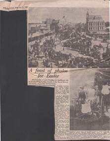
Newspaper - 1980 NEWSPAPER ARTICLE: THE DISPLAY OF EARLY BENDIGO PHOTOS BY THE ROYAL HISTORICAL SOCIETY
... flooding into Howard Place in 1898. The bottom photo was taken at an Easter procession during the 1890's Newspaper 1980 NEWSPAPER ARTICLE: THE DISPLAY OF EARLY BENDIGO PHOTOS BY THE ROYAL HISTORICAL SOCIETY ...2.4.1980 newspaper article re the display of early Bendigo photos by the Royal historical society .Photos shows Easter Parade photos .The top photo show crowds lining Pall Mall and flooding into Howard Place in 1898. The bottom photo was taken at an Easter procession during the 1890'snewspaper, bendigo advertiser, newspaper column -
 Sunshine and District Historical Society Incorporated
Archive - Maribyrnong River, Meat Works & the Living Museum of the West
... Sketch Humes Site Maribyrnong The Processes of Meat Preserving The Tin Shop|Sketch Humes Site Maribyrnong The Processes of Meat Preserving The Works|Sketch Humes Site Maribyrnong The Processes of Meat Preserving The Store Room|Sketch Humes Site Maribyrnong The Processes of Meat Preserving The Kitchen|Sketch Humes Site Maribyrnong The Processes of Meat Preserving The Preserving Room|Sketch Humes Site Maribyrnong The Processes of Meat Preserving The Boning Room|Sketch Humes Site Maribyrnong The Processes of Meat Preserving|Photograph Humes Site Maribyrnong|Newspaper article The Advocate 14 June 1995 Cannery building highlight at park|Newspaper article Times 12 February 2002 Chemical free restoration|Extract ADI Footscray Site Redevelopment Site History Historical Overview|Brochure Discover the Maribyrnong|Newspaper article Essendon Gazette 3 March 2021 Long Distance Swim|Newspaper article Star 4 May 2004 Plan to save Cinderella river|Typed Report Memories of early Maribyrnong|Newspaper article The Herald 11 December 1981 The battle over the bluestone|Plans Kevin McManus Architect Possible Development Humes Site Maribyrnong|Photocopy painting of Humes Site Maribyrnong|Newspaper article The Sun 1 June 1979 A face lift for our Cinderella River|Newspaper article The Age 9 November 1982 Messsing about on the forgotten river|Extract Our Unique Victorian Timber Bridge Heritage article|Invitation to a Meeting Our River Heritage and its future|Typed Report February 1992 Maribyrnong River Valley Braybrook A time of Achievement of community Aspirations|Letter 14 February 1983 from Melbourne and Metropolitan Board of Works|Typed Notes Meeting to discuss the erection of a cairn at Solomons Ford|Letter 30 July 1980 from Melbourne and Metropolitan Board of Works Former Melbourne Meat Preserving Company Maribyrnong|Letter 1 December 1981 to Melbourne and Metropolitan Board of Works from Melbourne Metropolitan Planning Scheme Amendment No 157|Extract Maribyrnong Action in Tranquility by Olwen Ford and Pamela Lewis|Handwritten notes about Maribyrnong|Typed report 11 September 1976 Maribyrnong History|Newspaper article The Mail 10 February 1993 Maribyrnong turns back the clock|Newspaper article Advocate 29 September 1993 Misery of flood victims to continue Govt rejects river report|Newspaper article Sunshine Advocate 28M Arundel Dam plan scrapped|Flyer The Maribyrnong River Ideas for the River Valley|Newspaper article The Western Times 12 September 1984 Govt breathes new life into a forgotten river|Newspaper article The Western Times 8 February 1984 So where is the real Solomons Ford|Letter 28 April 1960 Maribyrnong|Newspaper article Melbourne must not forget its other river Olwen Ford|Flyer Ecomuseum Broadsheets 4 Maribyrnong River A River of Histoy|Flyer Pipemakers Park Maribyrnong|Typed report The Saltwater River Powder Magazine Jacks Magazine J W Moore|The Heritage Plan Maribyrnong City Council February 2002|Flyer Bicycling in Maribyrnong|Flyer Pipe Trail|Flyer Meat Trail|Flyer Origins of Industry|Flyer Pipemakers Park|Typed Report Racing Colours Rose and Black|Photographs Maribyrnong Valley December 1974|Newspaper article Herald Sun 12/2/1991 - How the live west is won Pipemakers Park...Maribyrnong River Meat Works The Living Museum of the West Sketch Humes Site Maribyrnong The Processes of Meat Preserving The Tin Shop|Sketch Humes Site Maribyrnong The Processes of Meat Preserving The Works|Sketch Humes Site Maribyrnong The Processes of Meat Preserving The Store Room|Sketch Humes Site Maribyrnong The Processes of Meat Preserving The Kitchen|Sketch Humes Site Maribyrnong The Processes of Meat Preserving The Preserving Room|Sketch Humes Site Maribyrnong The Processes of Meat Preserving The Boning Room|Sketch Humes Site Maribyrnong The Processes of Meat Preserving|Photograph Humes Site Maribyrnong|Newspaper article The Advocate 14 June 1995 Cannery building highlight at park|Newspaper article Times 12 February 2002 Chemical free restoration|Extract ADI Footscray Site Redevelopment Site History Historical Overview|Brochure Discover the Maribyrnong|Newspaper article Essendon Gazette 3 March 2021 Long Distance Swim|Newspaper article Star 4 May 2004 Plan to save Cinderella river|Typed Report Memories of early Maribyrnong|Newspaper article The Herald 11 December 1981 The battle over the bluestone|Plans Kevin McManus Architect Possible Development Humes Site Maribyrnong|Photocopy painting of Humes Site Maribyrnong|Newspaper article The Sun 1 June 1979 A face lift for our Cinderella River|Newspaper article The Age 9 November 1982 Messsing about on the forgotten river|Extract Our Unique Victorian Timber Bridge Heritage article|Invitation to a Meeting Our River Heritage and its future|Typed Report February 1992 Maribyrnong River Valley Braybrook A time of Achievement of community Aspirations|Letter 14 February 1983 from Melbourne and Metropolitan Board of Works|Typed Notes Meeting to discuss the erection of a cairn at Solomons Ford|Letter 30 July 1980 from Melbourne and Metropolitan Board of Works Former Melbourne Meat Preserving Company Maribyrnong|Letter 1 December 1981 to Melbourne and Metropolitan Board of Works from Melbourne Metropolitan Planning Scheme Amendment No 157|Extract Maribyrnong Action in Tranquility by Olwen Ford and Pamela Lewis|Handwritten notes about Maribyrnong|Typed report 11 September 1976 Maribyrnong History|Newspaper article The Mail 10 February 1993 Maribyrnong turns back the clock|Newspaper article Advocate 29 September 1993 Misery of flood victims to continue Govt rejects river report|Newspaper article Sunshine Advocate 28M Arundel Dam plan scrapped|Flyer The Maribyrnong River Ideas for the River Valley|Newspaper article The Western Times 12 September 1984 Govt breathes new life into a forgotten river|Newspaper article The Western Times 8 February 1984 So where is the real Solomons Ford|Letter 28 April 1960 Maribyrnong|Newspaper article Melbourne must not forget its other river Olwen Ford|Flyer Ecomuseum Broadsheets 4 Maribyrnong River A River of Histoy|Flyer Pipemakers Park Maribyrnong|Typed report The Saltwater River Powder Magazine Jacks Magazine J W Moore|The Heritage Plan Maribyrnong City Council February 2002|Flyer Bicycling in Maribyrnong|Flyer Pipe Trail|Flyer Meat Trail|Flyer Origins of Industry|Flyer Pipemakers Park|Typed Report Racing Colours Rose and Black|Photographs Maribyrnong Valley December 1974|Newspaper article Herald Sun 12/2/1991 - How the live west is won Pipemakers Park Collection of articles relating to the Maribyrnong River Meat Works Living Museum of the West and other articles relating to the Maribyrnong River Archive Maribyrnong River, Meat Works & the Living Museum of the West ...Sketch Humes Site Maribyrnong The Processes of Meat Preserving The Tin Shop|Sketch Humes Site Maribyrnong The Processes of Meat Preserving The Works|Sketch Humes Site Maribyrnong The Processes of Meat Preserving The Store Room|Sketch Humes Site Maribyrnong The Processes of Meat Preserving The Kitchen|Sketch Humes Site Maribyrnong The Processes of Meat Preserving The Preserving Room|Sketch Humes Site Maribyrnong The Processes of Meat Preserving The Boning Room|Sketch Humes Site Maribyrnong The Processes of Meat Preserving|Photograph Humes Site Maribyrnong|Newspaper article The Advocate 14 June 1995 Cannery building highlight at park|Newspaper article Times 12 February 2002 Chemical free restoration|Extract ADI Footscray Site Redevelopment Site History Historical Overview|Brochure Discover the Maribyrnong|Newspaper article Essendon Gazette 3 March 2021 Long Distance Swim|Newspaper article Star 4 May 2004 Plan to save Cinderella river|Typed Report Memories of early Maribyrnong|Newspaper article The Herald 11 December 1981 The battle over the bluestone|Plans Kevin McManus Architect Possible Development Humes Site Maribyrnong|Photocopy painting of Humes Site Maribyrnong|Newspaper article The Sun 1 June 1979 A face lift for our Cinderella River|Newspaper article The Age 9 November 1982 Messsing about on the forgotten river|Extract Our Unique Victorian Timber Bridge Heritage article|Invitation to a Meeting Our River Heritage and its future|Typed Report February 1992 Maribyrnong River Valley Braybrook A time of Achievement of community Aspirations|Letter 14 February 1983 from Melbourne and Metropolitan Board of Works|Typed Notes Meeting to discuss the erection of a cairn at Solomons Ford|Letter 30 July 1980 from Melbourne and Metropolitan Board of Works Former Melbourne Meat Preserving Company Maribyrnong|Letter 1 December 1981 to Melbourne and Metropolitan Board of Works from Melbourne Metropolitan Planning Scheme Amendment No 157|Extract Maribyrnong Action in Tranquility by Olwen Ford and Pamela Lewis|Handwritten notes about Maribyrnong|Typed report 11 September 1976 Maribyrnong History|Newspaper article The Mail 10 February 1993 Maribyrnong turns back the clock|Newspaper article Advocate 29 September 1993 Misery of flood victims to continue Govt rejects river report|Newspaper article Sunshine Advocate 28M Arundel Dam plan scrapped|Flyer The Maribyrnong River Ideas for the River Valley|Newspaper article The Western Times 12 September 1984 Govt breathes new life into a forgotten river|Newspaper article The Western Times 8 February 1984 So where is the real Solomons Ford|Letter 28 April 1960 Maribyrnong|Newspaper article Melbourne must not forget its other river Olwen Ford|Flyer Ecomuseum Broadsheets 4 Maribyrnong River A River of Histoy|Flyer Pipemakers Park Maribyrnong|Typed report The Saltwater River Powder Magazine Jacks Magazine J W Moore|The Heritage Plan Maribyrnong City Council February 2002|Flyer Bicycling in Maribyrnong|Flyer Pipe Trail|Flyer Meat Trail|Flyer Origins of Industry|Flyer Pipemakers Park|Typed Report Racing Colours Rose and Black|Photographs Maribyrnong Valley December 1974|Newspaper article Herald Sun 12/2/1991 - How the live west is won Pipemakers Parkmaribyrnong river, meat works, the living museum of the west -
 Ballarat Tramway Museum
Photograph - Black & White Photograph/s, The Courier Ballarat, 27/05/1963 12:00:00 AM
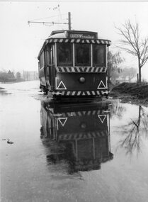
... floods. Collected by Alan Bradley from the Ballarat Courier early 1980's. ...floods. Collected by Alan Bradley from the Ballarat Courier early 1980's. ...Yields information about the occasional weather conditions that a tramway operation around Lake Wendouree could encounter - flooding.Black and White copy photograph of a newspaper photograph taken by The Courier - 27/5/1963, published 28/5/1963 of No. 14 in water (blocked drain), Wendouree Parade & St Aidans Dve - wading through the floods. Collected by Alan Bradley from the Ballarat Courier early 1980's. See Excel file "Record of Ballarat Courier Photos SEC era" (Archive Documents) for source of details. See Reg Item 5604 for original of newspaper cutting.On rear stamped "Copyright, The Ballarat Courier Proprietary Limited." and in pencil "B.C. Battern".tramways, trams, wendouree parade, flooding, st aidans drive, tram 14 -
 Kew Historical Society Inc
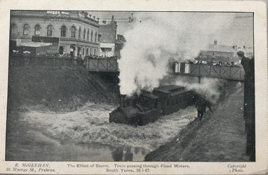
Postcard, R McGeehan, The Effect of Storm. Train Passing Through Flood Waters, South Yarra, 25-1-07, 1907
... Bennett, 1980 Postcard depicting a flood at South Yarra Station in 1907. ...SHARP DOWNPOUR. ONE INCH IN 45 MINUTES. SOUTHERN SUBURBS DELUGED. TRAIN STOPPED AT SOUTH YARRA. One of the sudden downpours of rain which occasionally fall in Melbourne occurred yesterday afternoon, when nearly an inch of rain fell in the course of three quarters of an hour, and caused a flood for an hour or two in certain localities. During the early part of the day, the sky had been clouded over, but there was nothing to indicate a storm of such intensity as that which followed. At about half-past 1 o'clock residents of South Yarra, South Melbourne, Prahran, and St. Kilda noticed a few drops of rain. Still, it appeared unlikely that there would be anything exceptional, until with startling suddenness at about 10 minutes to 1 o'clock, one of the heaviest downpours within the memory of residents burst upon those suburbs. A strange feature of the storm was that it was practically confined to an area of about three miles square. The city was but little affected, though at a spot as close as the Observatory 86 points of rain were recorded in three-quarters of an hour. Thunder and lightning accompanied the downpour, which was cyclonic in character, the rain driving heavily from all points of the compass as the cyclone passed. It was in South Yarra and Prahran that the rain fell heaviest. Within a few minutes after it commenced, the low-lying portions of Toorak-road and practically the whole length of Chapel-street were under water. The depression at the intersection of Toorak-road and Darling-street speedily filled to the dimensions of a small lake. Several shops were inundated, while the water from the higher levels rushed down like a mountain torrent, and in several in-stances swept through the rear of houses and shops, carrying furniture in a floating mass against the further walls. In one case a footbridge was carried bodily away and dashed to pieces. Darling-street itself Great Davis-street, and other low-lying and flat thoroughfares in the vicinity became flooded from kerb to kerb, while on the other side of the railway-bridge the valley between Kensington-road and River-street became filled for some minutes to a depth of several feet. Meanwhile the waters from South Yarra hill, seeking a lower level, found it in the railway cutting, and the excavations from South Yarra station to Prahran on the one line, and to the Chapel-street bridge on the other, were converted into a couple of canals. At the platforms at South Yarra the water was two feet deep on the permanent way, and towards Hawksburn, at the sudden depression under Chapel-street bridge, it was at one time deep enough to cover a tall man's head. Into this swirling mass of water the 1:50 p.m. train from Oakleigh plunged on its way to Melbourne. The impact caused a mighty fountain of water to rise to a height of about 20 feet above the level of Chapel-street and send clouds of spray in all directions. Under the belief that a terrible explosion had occurred residents braved the rain and rushed to the spot, only to find that the train had been brought to a stand-still in the middle of what seemed to be a river. The water was so high that it had entered the fire-box from below, extinguishing the fires and cutting off the steam supply. In the meantime the officials at the South Yarra station had been preparing for emergencies. Inspectors were on duty at intervals along the line, and the moment the alarm was given an extra engine was backed carefully down and continued on to connect with the stranded train without losing its own power. There was a delay of about ten minutes in the service for an hour or two, but by 5 o'clock all the trains were running on time again, and the water had run off all but the spot beneath the Chapel-street bridge. Here the water remained about four feet deep until nightfall, and throughout the afternoon several hundreds of people including biograph operators and photographers, were gathered around watching each train pass through. Even with the water two feet lower, this was a work attended with considerable difficulty. Each train had to absolutely force its way through the weight of water, almost enveloped by the spray thrown up, and it was only just able to negotiate the "ford" by using every ounce of steam. ... The Argus, 26 January 1907, p19.The item forms part of the Laurie Bennett collection of thirty-six postcards and photographs of Kew and early Melbourne, donated to the Kew Historical Society in 1980. The postcards in the Bennett collection, like other images in the Society's holdings date from the 1890s to the present and comprehensively indicate points-of-view or scenes considered historically, aesthetically or socially significant in the period in which they were produced.Postcard depicting a flood at South Yarra Station in 1907. The title and photographer's name are identified on the front of the postcard. Donated by L. Bennett, 1980flood - south yarra, trains - melbourne, postcards, r mcgeehan - prahran -
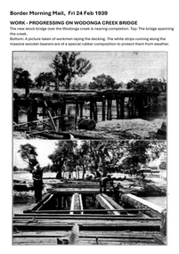 Wodonga & District Historical Society Inc
Photograph - Wodonga Creek Stock Bridge Collection
... 1980 the Wodonga Saleyards were relocated to Bandiana to the east of the city. This meant that Wodonga Creek Stock Bridge was no longer needed for its original purpose. Although listed as a significant site by the Victorian Heritage and National Heritage Trust on 3/08/1998, the bridge fell into disrepair and also suffered damage from several floods. ...1980 the Wodonga Saleyards were relocated to Bandiana to the east of the city. This meant that Wodonga Creek Stock Bridge was no longer needed for its original purpose. Although listed as a significant site by the Victorian Heritage and National Heritage Trust on 3/08/1998, the bridge fell into disrepair and also suffered damage from several floods. ...The Wodonga Creek Stock Bridge was constructed by the Country Roads Board in 1939. The date was recorded on a small plaque attached to one of the trestles. The bridge is an important reminder of one of the industries Wodonga was built on — cattle. It was constructed to develop a new stock route between Albury and Wodonga which would direct cattle away from the main bitumen roads and traffic bridges to the Wodonga Saleyards, where thousands of sheep and cattle were sold each month. It is a moderately tall timber trestle road bridge consisting of nine spans, with a deck length of 76 metres and deck width of 4.5 metres, and a maximum span length of 8.5 metres. The substantial timber deck featured decking laid horizontally and longitudinal running planks laid on top of it. The bridge also has timber side safety rails to discourage livestock from straying over the side. The bridge also became the centre of summer social activity for the young people of Wodonga as the area became a gazetted swimming area before the Wodonga Swimming Pool was constructed in 1959. In 1980 the Wodonga Saleyards were relocated to Bandiana to the east of the city. This meant that Wodonga Creek Stock Bridge was no longer needed for its original purpose. Although listed as a significant site by the Victorian Heritage and National Heritage Trust on 3/08/1998, the bridge fell into disrepair and also suffered damage from several floods. A suspension Bridge was constructed beside the Stock Route Bridge in 2013 and the old bridge was closed to traffic. Major damage caused by several floods, including a major flood in 2022 has resulted in the bridge being unsafe and its future is uncertain. The model of the Wodonga Creek Stock Bridge in our Collection made by Mr John Wild, depicts its current condition.The Wodonga Creek Stock Bridge is significant for technical, historic and social reasons and has been registered at the State Heritage level. It is of technical significance as a nine span bridge with tall timber trestles. Large bridges of this type are now very rare in Victoria. It is of historic significance as a surviving structurally authentic bridge designed specifically for livestock and drover use, on a historic stock route. The Stock Bridge is of social significance for its location at a popular riverside leisure spot since its construction in 1939.A collection of photographic images depicting the Wodonga Creek Stock Bridge. It contains both black and white and coloured images taken at different times in the Stock Bridge's history. A model of the Bridge made for Our Society is also included.wodonga creek stock bridge, wodonga heritage -
 Yarrawonga and Mulwala Pioneer Museum
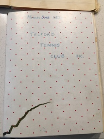
Telford Tennis Club minute books and records, 1920's to 2019
... flooded. At the beginning of the season working bees were held to remove the weeds. mow the surrounds and line the courts During the early 1980's the courts were abandoned and home matches were played at the Yarrawonga Lawn Tennis courts. ...flooded. At the beginning of the season working bees were held to remove the weeds. mow the surrounds and line the courts During the early 1980's the courts were abandoned and home matches were played at the Yarrawonga Lawn Tennis courts. ...Telford Tennis courts were situated on the Telford Yarrawonga Road, west of the railway line, Telford station and silos. A thriving club existed from early 1920's with players from surrounding areas in early times. balls and tournaments were held as fundraisers. Prominent family names included Stevenson, Chappell, Mulquiney, Thom, Inchbold, Connell. Quinn. There were three teams during the 1960's playing in the Wilby and District Tennis Association ( WDTA) competition. Opponents included Wilby, Almonds, St Mary's, Bundalong, Savernake, Rennie, Roseneath, Burramine. Being in a low lying area the Telford dirt courts were often flooded. At the beginning of the season working bees were held to remove the weeds. mow the surrounds and line the courts During the early 1980's the courts were abandoned and home matches were played at the Yarrawonga Lawn Tennis courts. The club still has a team in the WDTA in 2019. A number of B grade Premierships have been won over the years however A grade premierships have been non existent. The club has always encouraged juniors to play and now the players mostly originate from Yarrawonga. Current President (2019) is Richard Inchbold, Secretary/Treasurer Joan Thom. The Bank account is held at the CMCU. The club is no longer IncorporatedCountry tennis teams provided a social outlet from the farming pursuits of the districtall enclosed in a cardboard box. Minute books 1927 to 2014 (not all complete). Includes photos, paper cuttings, Wilby and District Tennis Association draws, subs books, list of names of those who have played for Telford. Consumer Affairs returns, Incorporation papers, receipt books, some correspondence (later years)see photos -
 Kew Historical Society Inc
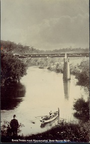
Postcard, River Yarra near Macauleys' Boathouse Kew, c.1910
... This bridge was destroyed in the 1934 Flood and later reconstructed. bridges - kew (vic.) bridges - yarra river -- kew (vic.) pipe bridge Obverse: "River Yarra near Macauleys' Boat House Kew". Reverse: "(Pipe Water Line) / Kew to Fairfield above boat house / Pipe Bridge / Received from L. Bennett 1980 ...The Pipe Bridge was constructed to bring fresh water from Fairfield to Kew. This bridge was destroyed in the 1934 Flood and later reconstructed.Early sepia real photo postcard of the first Pipe Bridge bringing water from the Yan Yean Reservoir to Kew. The site is upriver of the original Macauley's boathouse. Obverse: "River Yarra near Macauleys' Boat House Kew". Reverse: "(Pipe Water Line) / Kew to Fairfield above boat house / Pipe Bridge / Received from L. Bennett 1980".bridges - kew (vic.), bridges - yarra river -- kew (vic.), pipe bridge -
 Kew Historical Society Inc
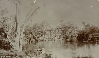
Postcard, River Yarra near Macauleys' Boathouse Kew
... 1980 / Bridge between Old Asylum & new Mental Hosp. / Kew side" Sepia postcard of the Zig-zaf Bridge joining Yarra Bend and Studley Park. In the foreground is a rowboat in which a man is standing, behind whom are two women in hats and a young child. The man appears to be pushing the boat away from the Bank. In the distance is the wooden Zig-Zag Bridge, constructed in the 1870s to link the Yarra Bend and Kew Lunatic Asylums. [Destroyed by flood ...Sepia postcard of the Zig-zaf Bridge joining Yarra Bend and Studley Park. In the foreground is a rowboat in which a man is standing, behind whom are two women in hats and a young child. The man appears to be pushing the boat away from the Bank. In the distance is the wooden Zig-Zag Bridge, constructed in the 1870s to link the Yarra Bend and Kew Lunatic Asylums. [Destroyed by flood, 1929.]Obverse: "River Yarra near Macauleys' Boathouse Kew". Reverse: "Zig Zag Bridge / Gift from L Bennett 1980 / Bridge between Old Asylum & new Mental Hosp. / Kew side"zig-zag bridge -- kew (vic.), bridges -- river yarra, bridges -- kew (vic.) -
 Kew Historical Society Inc
Photograph - Yarra in Flood - Belford & Kilby Farms, 1903
... Part of a large collection of photographs and postcards in the collection laurie bennett eileen mary bennett eileen mary clark floods -- yarra -- 1903 Panoramic photographic positive of North Kew where the Belford and Kilby Farms were located on the south side of the Yarra River. This photo, donated in 1980 ...In 1980, Mr Laurie Bennett presented the Kew Historical Society with a number of photographs and postcards from the estate of his mother Eileen Mary Bennett (nee Clark). His mother was the daughter of Lawrence FH Clark(?-1946) and Mary Clark (?-1925) of 22 Harp Road, East Kew, in whose yard the photograph was taken. A year before the donation occurred a notice appeared in the Canberra Times stating that: "BENNETT, Eileen Mary. — May 8th at Tuross Heads, N.S.W. Late of 22 Harp Rd, East Kew, (Vic). Dearly loved wife of the late Harold Bennett, loved mother and mother in law of Laurie and Shirley (Melbourne), Kevin and Doreen (Canberra), grandmother of Linda, Stephen, Paul, Gabrielle, Peter, Mark and Jon."Part of a large collection of photographs and postcards in the collectionPanoramic photographic positive of North Kew where the Belford and Kilby Farms were located on the south side of the Yarra River. This photo, donated in 1980 by Laurie Bennett is the original of the two identical photos in the collection.laurie bennett, eileen mary bennett, eileen mary clark, floods -- yarra -- 1903