B-24 Liberator Memorial Restoration Australia Inc
Map - US World War II multi-coloured map- Southwest Pacific Area, No. 23 North Celebes, No. 24 South Celebes, 1942-1943
... ...a189...This map, printed on acetate rayon, is an original US 'escape and evasion' kit map from World War II. world war ii silk maps united states of america a189 AAF Cloth Map - Southwest Pacific Area
Side 1 - No. 23 North Celebes
Side 2 - No. 24 South Celebes A multi-coloured, contoured, double-sided map printed on acetate rayon Map US World War II multi-coloured map- Southwest Pacific Area, No. 23 North Celebes, No. 24 South Celebes ...
Silk and rayon maps were produced by the United States (c. 7.5 million in total), Great Britain (some 1.75 million in total) and Australia during World War II. They were issued to Allied military personnel as part of 'escape and evasion' kits.This map, printed on acetate rayon, is an original US 'escape and evasion' kit map from World War II.A multi-coloured, contoured, double-sided map printed on acetate rayon AAF Cloth Map - Southwest Pacific Area
Side 1 - No. 23 North Celebes
Side 2 - No. 24 South Celebesworld war ii, silk maps, united states of america, a189
 Glenelg Shire Council Cultural Collection
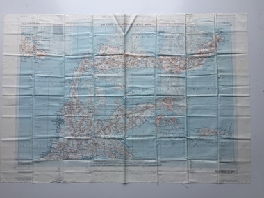 B-24 Liberator Memorial Restoration Australia Inc