Showing 72 items matching "acheron valley"
-
 Victorian Railway History Library
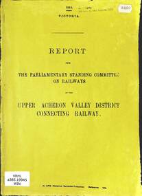
Booklet, Parliamentary Standing Committee of Victoria, Upper Acheron Valley District Connecting Railway, 1918
... Upper Acheron Valley District Connecting Railway...Victorian Railway History Library 39 St Edmonds Rd Prahran Prahran Railroad construction - Victoria - history VR narrow gauge railways - Victoria - history The parliamentary standing committee on Railways on the question of a connecting railway in the Upper Acheron Valley district in Victoria. p.12. Upper Acheron Valley District Connecting Railway Booklet Parliamentary Standing Committee of Victoria ...The parliamentary standing committee on Railways on the question of a connecting railway in the Upper Acheron Valley district in Victoria.p.12.non-fictionThe parliamentary standing committee on Railways on the question of a connecting railway in the Upper Acheron Valley district in Victoria.railroad construction - victoria - history, vr narrow gauge railways - victoria - history -
 Marysville & District Historical Society
THE TRIANGLE NEWS-VOL 28 NO 32-24 AUGUST 2001
... ...acheron valley alpacas...Marysville & District Historical Society 39 Darwin Street Marysville yarra-valley-and-the-dandenong-ranges marysville victoria australia taggerty market tallarook to alexandra rail plan lake mountain snowline report marysville festival committee acheron valley alpacas country store and gallery urgently wanted marysville primary school news pupils of the week THE TRIANGLE NEWS-VOL 28 NO 32-24 AUGUST 2001 ...marysville, victoria, australia, taggerty market, tallarook to alexandra rail plan, lake mountain snowline report, marysville festival committee, acheron valley alpacas, country store and gallery, urgently wanted, marysville primary school news, pupils of the week -
 Marysville & District Historical Society
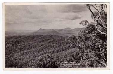
Postcard (item) - Black and white postcard, Valentine Publishing Co. Pty. Ltd, Cathedral Range, From Mount Gordon, Marysville. V. 24, 1923-1963
... ...acheron valley...The Cathedral Range sweeps up from the Acheron Valley and is a distinctive regional landmark of high craggy peaks and sandstone cliffs. ...An early black and white photograph of the Cathedral Range taken from Mount Gordon near Marysville in Victoria.An early black and white photograph of the Cathedral Range taken from Mount Gordon near Marysville in Victoria. The Cathedral Range sweeps up from the Acheron Valley and is a distinctive regional landmark of high craggy peaks and sandstone cliffs. The park is notable for its spectacular walking trails and challenging rock climbs. This postcard was published by the Valentine Publishing Co. Pty. Ltd. as a souvenir of Marysville.VALENTINE'S/ POST CARD/ A GENUINE PHOTOGRAPHcathedral range, mount gordon, marysville, victoria, postcard, valentine publishing co, souvenir, acheron valley -
Marysville & District Historical Society
Article (item) - Book Extract, Aboriginal History, Unknown
... ...acheron valley...The extract also covers current (1991) status of Aboriginal affairs and European settlement of the area. kulin nation woiworung taungurong bunurong watherong jajowrong wurrundjeri-willam waring-ilam-balluk goulburn valley acheron valley upper goulburn district eildon-thornton eildon homestead o'rourke thornton assistant protector thomas yarra valley kilmore mount william jt gellibrand william buckley major mitchell port phillip murray river yorta yorta yowung-illam-balluk waring-illam-balluk ngurai-illam-wurrung kurnai nation protectorate system victoria george robinson chief protector willam thomas james dredge edward parker charles sievewright central board for the protection of aborigines presbyterian mission anglican mission moravian mission wonga munnarin beaning murrin murrin parugean baruppin koo-gurrin acheron river little river acheron run peter snodgrass stephen jones barak dividing range black spur watts river badger creek healesville coranderrk victorian christmas bush aboriginal and torres strait islander heritage protection act 1984 archaelological and aboriginal relics preservation act 1972 camp jungai rubicon warrawa college victorian archaeological survey hume and hovell molesworth broadford william hamilton alexandra mansfield avenel tallarook worrough john cotton trawool valley seymour pyalong gold mining central victoria strath creek reedy creek yea jamieson marysville jordan goldfields comet mine wandong melbourne-albury railway rabbit plague narbethong lord kitchener puckapunyal military camp 1944 decentralisation policy eildon weir hume freeway bypass timber industry australian paper manufacturers mill An extract from a book regarding a brief history of the Kulin nation of the North Central district of Victoria. ...An extract from a book regarding a brief history of the Kulin nation of the North Central district of Victoria.An extract from a book regarding a brief history of the Kulin nation of the North Central district of Victoria. This history covered is both prior to European history and post-European history. The extract also covers current (1991) status of Aboriginal affairs and European settlement of the area.kulin nation, woiworung, taungurong, bunurong, watherong, jajowrong, wurrundjeri-willam, waring-ilam-balluk, goulburn valley, acheron valley, upper goulburn district, eildon-thornton, eildon homestead, o'rourke, thornton, assistant protector thomas, yarra valley, kilmore, mount william, jt gellibrand, william buckley, major mitchell, port phillip, murray river, yorta yorta, yowung-illam-balluk, waring-illam-balluk, ngurai-illam-wurrung, kurnai nation, protectorate system, victoria, george robinson, chief protector, willam thomas, james dredge, edward parker, charles sievewright, central board for the protection of aborigines, presbyterian mission, anglican mission, moravian mission, wonga, munnarin, beaning, murrin murrin, parugean, baruppin, koo-gurrin, acheron river, little river, acheron run, peter snodgrass, stephen jones, barak, dividing range, black spur, watts river, badger creek, healesville, coranderrk, victorian christmas bush, aboriginal and torres strait islander heritage protection act 1984, archaelological and aboriginal relics preservation act 1972, camp jungai, rubicon, warrawa college, victorian archaeological survey, hume and hovell, molesworth, broadford, william hamilton, alexandra, mansfield, avenel, tallarook, worrough, john cotton, trawool valley, seymour, pyalong, gold mining, central victoria, strath creek, reedy creek, yea, jamieson, marysville, jordan goldfields, comet mine, wandong, melbourne-albury railway, rabbit plague, narbethong, lord kitchener, puckapunyal military camp, 1944 decentralisation policy, eildon weir, hume freeway bypass, timber industry, australian paper manufacturers mill -
 Marysville & District Historical Society
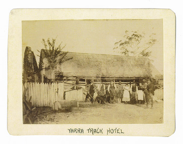
Photograph (Item) - Black and white photograph, Yarra Track Hotel, c1900
... ...acheron valley...The Track involved the climbing of the Black Spur, descent into the Acheron Valley, and then through Marysville to the Cumberland where it followed the existing route. ...An early black and white photograph of a hotel along the Yarra Track.An early black and white photograph of a hotel along the Yarra Track. The Yarra Track is the former name of the gold fields road from Healesville to the Woods Point and Jordan Goldfields, in Victoria, Australia. A direct route via the Yarra River and the Great Divide was discovered by Rieck in September 1862 and became known as the Yarra Track. Early in 1863, the Victorian Government decided to construct a 193-kilometre (120 mile) road along the route. Its original width varied between 4 and 6 metres (12 and 20 feet), and was designed to accommodate horse-drawn vehicles. The Track involved the climbing of the Black Spur, descent into the Acheron Valley, and then through Marysville to the Cumberland where it followed the existing route. Unable to ascertain both the location and name of hotel.ARMSTRONG COLLECTION 42 STATION STREET/ SANDRINGHAM 3191/ TEL. (03) 9521 5442/ IAN M.L. ARMSTRONG OAMyarra track, healesville, wood's point, jordan goldfields, victoria, yarra river, great divide, reick, black spur, acheron valley, marysville, cumberland creek -
 Marysville & District Historical Society
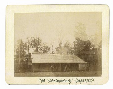
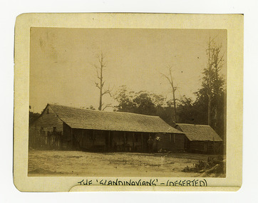
Photograph (Item) - Black and white photograph, The "Scandinavians' - (Deserted), c1900
... ...acheron valley...The Track involved the climbing of the Black Spur, descent into the Acheron Valley, and then through Marysville to the Cumberland where it followed the existing route. the scandinavians' yarra track healesville wood's point jordan goldfields victoria yarra river great divide reick black spur acheron valley marysville cumberland creek ARMSTRONG COLLECTION 42 STATION STREET/ SANDRINGHAM 3191/ TEL. (03) 9521 5442/ IAN M.L. ...An early black and white photograph of The Scandinavian's Hotel and Boarding House along the Yarra Track.An early black and white photograph of The Scandinavian's Hotel and Boarding House along the Yarra Track. The Yarra Track is the former name of the gold fields road from Healesville to the Woods Point and Jordan Goldfields, in Victoria, Australia. A direct route via the Yarra River and the Great Divide was discovered by Rieck in September 1862 and became known as the Yarra Track. Early in 1863, the Victorian Government decided to construct a 193-kilometre (120 mile) road along the route. Its original width varied between 4 and 6 metres (12 and 20 feet), and was designed to accommodate horse-drawn vehicles. The Track involved the climbing of the Black Spur, descent into the Acheron Valley, and then through Marysville to the Cumberland where it followed the existing route.ARMSTRONG COLLECTION 42 STATION STREET/ SANDRINGHAM 3191/ TEL. (03) 9521 5442/ IAN M.L. ARMSTRONG OAMthe scandinavians', yarra track, healesville, wood's point, jordan goldfields, victoria, yarra river, great divide, reick, black spur, acheron valley, marysville, cumberland creek -
 Marysville & District Historical Society
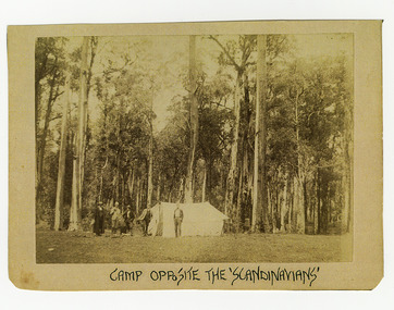
Photograph (Item) - Black and white photograph, Camp Opposite The "Scandinavians', c1900
... ...acheron valley...The Track involved the climbing of the Black Spur, descent into the Acheron Valley, and then through Marysville to the Cumberland where it followed the existing route. the scandinavians' yarra track healesville wood's point jordan goldfields victoria yarra river great divide reick black spur acheron valley marysville cumberland creek ARMSTRONG COLLECTION 42 STATION STREET/ SANDRINGHAM 3191/ TEL. (03) 9521 5442/ IAN M.L. ...An early black and white photograph of a camp which was opposite The Scandinavian's Hotel and Boarding House along the Yarra Track.An early black and white photograph of a camp which was opposite The Scandinavian's Hotel and Boarding House along the Yarra Track. The Yarra Track is the former name of the gold fields road from Healesville to the Woods Point and Jordan Goldfields, in Victoria, Australia. A direct route via the Yarra River and the Great Divide was discovered by Rieck in September 1862 and became known as the Yarra Track. Early in 1863, the Victorian Government decided to construct a 193-kilometre (120 mile) road along the route. Its original width varied between 4 and 6 metres (12 and 20 feet), and was designed to accommodate horse-drawn vehicles. The Track involved the climbing of the Black Spur, descent into the Acheron Valley, and then through Marysville to the Cumberland where it followed the existing route.ARMSTRONG COLLECTION 42 STATION STREET/ SANDRINGHAM 3191/ TEL. (03) 9521 5442/ IAN M.L. ARMSTRONG OAMthe scandinavians', yarra track, healesville, wood's point, jordan goldfields, victoria, yarra river, great divide, reick, black spur, acheron valley, marysville, cumberland creek -
Marysville & District Historical Society
Booklet (Item) - Information booklet, Artworkz Tourism, The Big Culvert, Unknown
... ...acheron valley...The Track involved the climbing of the Black Spur, descent into the Acheron Valley, and then through Marysville to the Cumberland where it followed the existing route. the big culvert yarra track victoria healesville wood's point goldfields jordan goldfields black spur acheron valley cumberland valley An information booklet that was produced as a guide to The Big Culvert. ...An information booklet that was produced as a guide to The Big Culvert.An information booklet that was produced as a guide to The Big Culvert. The Big Culvert is a historic granite and bluestone arch along the Yarra Track, a major route to Melbourne through the 1800s. Built in 1870 and a major piece of infrastructure for its time, the heritage listed culvert allowed water to flow under often-flooded the road. The Yarra Track is the former name of the gold fields road from Healesville to the Woods Point and Jordan Goldfields, in Victoria, Australia. A direct route via the Yarra River and the Great Divide was discovered by Rieck in September 1862 and became known as the Yarra Track. Early in 1863, the Victorian Government decided to construct a 193-kilometre (120 mile) road along the route. Its original width varied between 4 and 6 metres (12 and 20 feet), and was designed to accommodate horse-drawn vehicles. The Track involved the climbing of the Black Spur, descent into the Acheron Valley, and then through Marysville to the Cumberland where it followed the existing route.the big culvert, yarra track, victoria, healesville, wood's point goldfields, jordan goldfields, black spur, acheron valley, cumberland valley -
Marysville & District Historical Society
Flyer (Item) - Information flyer, Artworkz Tourism, The Big Culvert, 26-03-2016
... ...acheron valley...The Track involved the climbing of the Black Spur, descent into the Acheron Valley, and then through Marysville to the Cumberland where it followed the existing route. the big culvert yarra track victoria healesville wood's point goldfields jordan goldfields black spur acheron valley cumberland valley An information flyer that was produced as a guide to The Big Culvert. ...An information flyer that was produced as a guide to The Big Culvert.An information flyer that was produced as a guide to The Big Culvert. The Big Culvert is a historic granite and bluestone arch along the Yarra Track, a major route to Melbourne through the 1800s. Built in 1870 and a major piece of infrastructure for its time, the heritage listed culvert allowed water to flow under often-flooded the road. The Yarra Track is the former name of the gold fields road from Healesville to the Woods Point and Jordan Goldfields, in Victoria, Australia. A direct route via the Yarra River and the Great Divide was discovered by Rieck in September 1862 and became known as the Yarra Track. Early in 1863, the Victorian Government decided to construct a 193-kilometre (120 mile) road along the route. Its original width varied between 4 and 6 metres (12 and 20 feet), and was designed to accommodate horse-drawn vehicles. The Track involved the climbing of the Black Spur, descent into the Acheron Valley, and then through Marysville to the Cumberland where it followed the existing route.the big culvert, yarra track, victoria, healesville, wood's point goldfields, jordan goldfields, black spur, acheron valley, cumberland valley -
 Marysville & District Historical Society
Photograph (Item) - Black and white photograph, Unknown
... ...acheron valley...The Track involved the climbing of the Black Spur, descent into the Acheron Valley, and then through Marysville to the Cumberland where it followed the existing route. the big culvert yarra track victoria healesville wood's point goldfields jordan goldfields black spur acheron valley cumberland valley Unveiling of sign/ at "Big Culvert" In front Max Cockerrell and - Rear: second back Geoff Pope R.H.S. rear: Nancy "/ Anne " A black and white photograph taken at the unveiling of the sign placed at The Big Culvert. ...A black and white photograph taken at the unveiling of the sign placed at The Big Culvert.A black and white photograph taken at the unveiling of the sign placed at The Big Culvert. The Big Culvert is a historic granite and bluestone arch along the Yarra Track, a major route to Melbourne through the 1800s. Built in 1870 and a major piece of infrastructure for its time, the heritage listed culvert allowed water to flow under often-flooded the road. The Yarra Track is the former name of the gold fields road from Healesville to the Woods Point and Jordan Goldfields, in Victoria, Australia. A direct route via the Yarra River and the Great Divide was discovered by Rieck in September 1862 and became known as the Yarra Track. Early in 1863, the Victorian Government decided to construct a 193-kilometre (120 mile) road along the route. Its original width varied between 4 and 6 metres (12 and 20 feet), and was designed to accommodate horse-drawn vehicles. The Track involved the climbing of the Black Spur, descent into the Acheron Valley, and then through Marysville to the Cumberland where it followed the existing route.Unveiling of sign/ at "Big Culvert" In front Max Cockerrell and - Rear: second back Geoff Pope R.H.S. rear: Nancy "/ Anne "the big culvert, yarra track, victoria, healesville, wood's point goldfields, jordan goldfields, black spur, acheron valley, cumberland valley -
 Marysville & District Historical Society
Photograph (Item) - Colour photograph, 20-09-2008
... ...acheron valley...The Track involved the climbing of the Black Spur, descent into the Acheron Valley, and then through Marysville to the Cumberland where it followed the existing route. the big culvert yarra track victoria healesville wood's point goldfields jordan goldfields black spur acheron valley cumberland valley A colour photograph of the entrance to The Big Culvert. ...A colour photograph of the entrance to The Big Culvert.A colour photograph of the entrance to The Big Culvert. The Big Culvert is a historic granite and bluestone arch along the Yarra Track, a major route to Melbourne through the 1800s. Built in 1870 and a major piece of infrastructure for its time, the heritage listed culvert allowed water to flow under often-flooded the road. The Yarra Track is the former name of the gold fields road from Healesville to the Woods Point and Jordan Goldfields, in Victoria, Australia. A direct route via the Yarra River and the Great Divide was discovered by Rieck in September 1862 and became known as the Yarra Track. Early in 1863, the Victorian Government decided to construct a 193-kilometre (120 mile) road along the route. Its original width varied between 4 and 6 metres (12 and 20 feet), and was designed to accommodate horse-drawn vehicles. The Track involved the climbing of the Black Spur, descent into the Acheron Valley, and then through Marysville to the Cumberland where it followed the existing route.the big culvert, yarra track, victoria, healesville, wood's point goldfields, jordan goldfields, black spur, acheron valley, cumberland valley -
 Marysville & District Historical Society
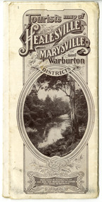
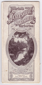
Map (Item) - Tourist Map, Tourists Resorts' Committee, Tourist's Map of Healesville Marysville and Warburton Districts, 13.10.1925
... ...the acheron valley...A tourist map for Healesville, Marysville and Warburton that was produced by the Tourists Resorts' Committee. healesville marysville warburton victoria tourists resorts' committee ben cairn mount donna buang the black's spur the acheron valley narbethong launching place tourist information tourism map tourist map Photo Lithographed at the Department of Lands and Survey, Melbourne by W.J. ...A tourist map for Healesville, Marysville and Warburton that was produced by the Tourists Resorts' Committee. This map was produced in 1925.A tourist map for Healesville, Marysville and Warburton that was produced by the Tourists Resorts' Committee.Photo Lithographed at the Department of Lands and Survey, Melbourne by W.J. Butson./ 13.10.25healesville, marysville, warburton, victoria, tourists resorts' committee, ben cairn, mount donna buang, the black's spur, the acheron valley, narbethong, launching place, tourist information, tourism, map, tourist map -
 Marysville & District Historical Society
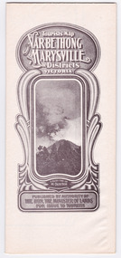
Map (Item) - Tourist Map, Department of Lands & Survey, Tourist's Map of Narbethong and Marysville Districts Victoria, 1913
... ...the acheron valley...A tourist map for the Narbethong and Marysville Districts that was originally produced by the Department of Lands & Survey in 1925. narbethong marysville victoria department of lands & survey the acheron valley warburton map tourist map Reprint of the 1925 Tourist brochure by permission R.E. ...A tourist map for the Narbethong and Marysville Districts that was originally produced by the Department of Lands & Survey in 1925.A tourist map for the Narbethong and Marysville Districts that was originally produced by the Department of Lands & Survey in 1925.Reprint of the 1925 Tourist brochure by permission R.E. Holmes Surveyor General By Authority: ALBERT J. MULLETT, Government Printer, Melbourne. Photo Lithographed at the Department of Lands and Survey Melbourne by W.J. Butson/ 26.8.13narbethong, marysville, victoria, department of lands & survey, the acheron valley, warburton, map, tourist map -
 Marysville & District Historical Society
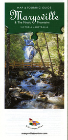
Map (Item) - Map and touring guide, Murrindindi Regional Tourism Association Inc, Marysville & The Mystic Mountains VICTORIA-AUSTRALIA, 08-2002
... ...acheron valley alpacas country store & gallery...A fold out map and touring guide of Marysville and the surrounding district published in 2002 by Murrindindi Regional Tourism Association Inc. marysville victoria australia map and touring guide mystic mountains tourism the beeches rainforest walk lake mountain cambarville cathedral range state park the cumberland abbey green b&b cottages anastasia fairytale cottage ashlar cottage b&b somerled mountain retreat baree mudbrick cottages blackwood cottages camellia cottage cathedral view b&b cottage riverside crossways country inn dalrymples guest cottages esa country ministries hillcrest keppels hotel motel kerami house lomatia lodge lyell guest cottages marylands country house marysville caravan park marysville holiday cottages maryton park melina cottage moondai farm b&b mountain lodge marysville mount cathedral lodge mystic mountains holiday cottages nanda binya lodge rendezvous on murchison scenic b&b the hermitage tower motel waratah house willowbank at taggerty woodlands of narbethong keppels lake mountain resort cafe lanterns at willowbank mantirri blueberry farm marysville country bakery the old woolshed cafe clearstream olives uncle fred & aunty val's old style lolly shop acheron valley alpacas country store & gallery bruno's art and sculpture garden country touch things of sand & stone willowbank gallery marysville auto & hardware marysville newsagency & general store marysville visitor information centre narbethong visitor information centre gallipoli park keppels lookout lady talbot drive steavenson falls steavenson river taggerty river acheron river black spur trail riding centre buxton trout farm lake mountain resort ski hire lake mountain ski school marysville district country club marysville ski centre narbethong ski hire rubicon horse riding country touch tours murrindindi regional tourism association inc A fold out map and touring guide of Marysville and the surrounding district published in 2002 by Murrindindi Regional Tourism Association Inc. ...A fold out map and touring guide of Marysville and the surrounding district published in 2002 by Murrindindi Regional Tourism Association Inc.A fold out map and touring guide of Marysville and the surrounding district published in 2002 by Murrindindi Regional Tourism Association Inc.marysville, victoria, australia, map and touring guide, mystic mountains tourism, the beeches rainforest walk, lake mountain, cambarville, cathedral range state park, the cumberland, abbey green b&b cottages, anastasia fairytale cottage, ashlar cottage b&b, somerled mountain retreat, baree mudbrick cottages, blackwood cottages, camellia cottage, cathedral view b&b, cottage riverside, crossways country inn, dalrymples guest cottages, esa country ministries, hillcrest, keppels hotel motel, kerami house, lomatia lodge, lyell guest cottages, marylands country house, marysville caravan park, marysville holiday cottages, maryton park, melina cottage, moondai farm b&b, mountain lodge marysville, mount cathedral lodge, mystic mountains holiday cottages, nanda binya lodge, rendezvous on murchison, scenic b&b, the hermitage, tower motel, waratah house, willowbank at taggerty, woodlands of narbethong, keppels, lake mountain resort cafe, lanterns at willowbank, mantirri blueberry farm, marysville country bakery, the old woolshed cafe, clearstream olives, uncle fred & aunty val's old style lolly shop, acheron valley alpacas country store & gallery, bruno's art and sculpture garden, country touch, things of sand & stone, willowbank gallery, marysville auto & hardware, marysville newsagency & general store, marysville visitor information centre, narbethong visitor information centre, gallipoli park, keppels lookout, lady talbot drive, steavenson falls, steavenson river, taggerty river, acheron river, black spur trail riding centre, buxton trout farm, lake mountain resort ski hire, lake mountain ski school, marysville district country club, marysville ski centre, narbethong ski hire, rubicon horse riding, country touch tours, murrindindi regional tourism association inc -
 Marysville & District Historical Society
Map (Item) - Tourist Map, Tourists Resorts' Committee, Tourist's Map of Healesville Marysville and Warburton Districts, 13.10.1925
... ...the acheron valley...A tourist map for Healesville, Marysville and Warburton that was produced by the Tourists Resorts' Committee. healesville marysville warburton victoria tourists resorts' committee ben cairn mount donna buang the black's spur the acheron valley narbethong launching place tourist information tourism map tourist map Photo Lithographed at the Department of Lands and Survey, Melbourne by W.J. ...A tourist map for Healesville, Marysville and Warburton that was produced by the Tourists Resorts' Committee. This map was produced in 1925.A tourist map for Healesville, Marysville and Warburton that was produced by the Tourists Resorts' Committee.Photo Lithographed at the Department of Lands and Survey, Melbourne by W.J. Butson./ 13.10.25healesville, marysville, warburton, victoria, tourists resorts' committee, ben cairn, mount donna buang, the black's spur, the acheron valley, narbethong, launching place, tourist information, tourism, map, tourist map -
 Marysville & District Historical Society
Map (Item) - Tourist Map, Department of Lands & Survey, Tourist's Map of Narbethong and Marysville Districts Victoria, 1913
... ...the acheron valley...A tourist map for the Narbethong and Marysville Districts that was originally produced by the Department of Lands & Survey in 1925. narbethong marysville victoria department of lands & survey the acheron valley warburton map tourist map Reprint of the 1925 Tourist brochure by permission R.E. ...A tourist map for the Narbethong and Marysville Districts that was originally produced by the Department of Lands & Survey in 1925.A tourist map for the Narbethong and Marysville Districts that was originally produced by the Department of Lands & Survey in 1925.Reprint of the 1925 Tourist brochure by permission R.E. Holmes Surveyor General By Authority: ALBERT J. MULLETT, Government Printer, Melbourne. Photo Lithographed at the Department of Lands and Survey Melbourne by W.J. Butson/ 26.8.13narbethong, marysville, victoria, department of lands & survey, the acheron valley, warburton, map, tourist map -
 Marysville & District Historical Society
Map (Item) - Map and touring guide, Murrindindi Regional Tourism Association Inc, Marysville & The Mystic Mountains VICTORIA-AUSTRALIA, 08-2002
... ...acheron valley alpacas country store & gallery...A fold out map and touring guide of Marysville and the surrounding district published in 2002 by Murrindindi Regional Tourism Association Inc. marysville victoria australia map and touring guide mystic mountains tourism the beeches rainforest walk lake mountain cambarville cathedral range state park the cumberland abbey green b&b cottages anastasia fairytale cottage ashlar cottage b&b somerled mountain retreat baree mudbrick cottages blackwood cottages camellia cottage cathedral view b&b cottage riverside crossways country inn dalrymples guest cottages esa country ministries hillcrest keppels hotel motel kerami house lomatia lodge lyell guest cottages marylands country house marysville caravan park marysville holiday cottages maryton park melina cottage moondai farm b&b mountain lodge marysville mount cathedral lodge mystic mountains holiday cottages nanda binya lodge rendezvous on murchison scenic b&b the hermitage tower motel waratah house willowbank at taggerty woodlands of narbethong keppels lake mountain resort cafe lanterns at willowbank mantirri blueberry farm marysville country bakery the old woolshed cafe clearstream olives uncle fred & aunty val's old style lolly shop acheron valley alpacas country store & gallery bruno's art and sculpture garden country touch things of sand & stone willowbank gallery marysville auto & hardware marysville newsagency & general store marysville visitor information centre narbethong visitor information centre gallipoli park keppels lookout lady talbot drive steavenson falls steavenson river taggerty river acheron river black spur trail riding centre buxton trout farm lake mountain resort ski hire lake mountain ski school marysville district country club marysville ski centre narbethong ski hire rubicon horse riding country touch tours murrindindi regional tourism association inc A fold out map and touring guide of Marysville and the surrounding district published in 2002 by Murrindindi Regional Tourism Association Inc. ...A fold out map and touring guide of Marysville and the surrounding district published in 2002 by Murrindindi Regional Tourism Association Inc.A fold out map and touring guide of Marysville and the surrounding district published in 2002 by Murrindindi Regional Tourism Association Inc.marysville, victoria, australia, map and touring guide, mystic mountains tourism, the beeches rainforest walk, lake mountain, cambarville, cathedral range state park, the cumberland, abbey green b&b cottages, anastasia fairytale cottage, ashlar cottage b&b, somerled mountain retreat, baree mudbrick cottages, blackwood cottages, camellia cottage, cathedral view b&b, cottage riverside, crossways country inn, dalrymples guest cottages, esa country ministries, hillcrest, keppels hotel motel, kerami house, lomatia lodge, lyell guest cottages, marylands country house, marysville caravan park, marysville holiday cottages, maryton park, melina cottage, moondai farm b&b, mountain lodge marysville, mount cathedral lodge, mystic mountains holiday cottages, nanda binya lodge, rendezvous on murchison, scenic b&b, the hermitage, tower motel, waratah house, willowbank at taggerty, woodlands of narbethong, keppels, lake mountain resort cafe, lanterns at willowbank, mantirri blueberry farm, marysville country bakery, the old woolshed cafe, clearstream olives, uncle fred & aunty val's old style lolly shop, acheron valley alpacas country store & gallery, bruno's art and sculpture garden, country touch, things of sand & stone, willowbank gallery, marysville auto & hardware, marysville newsagency & general store, marysville visitor information centre, narbethong visitor information centre, gallipoli park, keppels lookout, lady talbot drive, steavenson falls, steavenson river, taggerty river, acheron river, black spur trail riding centre, buxton trout farm, lake mountain resort ski hire, lake mountain ski school, marysville district country club, marysville ski centre, narbethong ski hire, rubicon horse riding, country touch tours, murrindindi regional tourism association inc -
 Marysville & District Historical Society
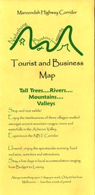
Map (Item) - Tourist and business map, Narbethong Community and Tourism Group, Narbethong Buxton Taggerty Tourist and Business Map, 04-2008
... ...acheron valley...A tourist and business map of Narbethong, Buxton and Taggerty. narbethong buxton taggerty victoria australia tourist and business map narbethong community and tourism group acheron valley yarra track wood's point black spur mystic mountains the meeting of the waters cathedral range danico design counted cross stitch things of sand & stone buxton zoo nursery & oddz & enz willowbank at taggerty safe trek 4wd services pnl 4wdriving buxton trout and salmon farm mystic mountains ski hire & outdoors narbethong ski hire highwood health centre cathedral view natural therapies narby cabinets plants by shelian gb timber executive signs rb automotive repairs buxton car care marysville towing & equipment hire martyn slade building design cathedral peak framing black spur roadhouse & ski hire tudor lodge roadhouse & ski hire buxton roadhouse & persian bazzar buxton post office general store & niche bar igloo roadhouse taggerty store narby eggs marapana agistment park mantirri blueberry farm carmyle farm hazelwood hazelnuts south cathedral lavender farm cathedral cherries black spur motel & caravan park woodlands rainforest retreat chestnut glade black spur inn wombat cottage abbey lake luxury b & b spa cottages blue views holiday cottages camp narbethong marapana farm stay b & b mantirri blueberry farm b & b little dene garden cottages silverstream b & b cottages nareen cabins moondai farm b & b south cathedral farm luxury b & b cottages yarrolyn caravan park sarsens rest lomah retreat pinjarra gardens kingbilli country estate henry viii manor house buxton hotel butters cafe of buxton wagtail wines little river wines lanterns at willowbank wirrawilla rainforest walk wilhemina falls the cascades This publication has been produced by the Narbethong Community and Tourism/ Group (NCTG) to promote the natural attractions, adventure activities and food/ trail from the Black Spur, through Narbethong, Buxton and Taggerty./ the information provided in this publication has been supplied by the individual/ members. ...A tourist and business map of Narbethong, Buxton and Taggerty. This map was produced by the Narbethong Community and Tourism Group in April 2008. It was produced to promote the natural attractions, adventure activities and food trail from the Black Spur, through Narbethong, Buxton and Taggerty.A tourist and business map of Narbethong, Buxton and Taggerty.This publication has been produced by the Narbethong Community and Tourism/ Group (NCTG) to promote the natural attractions, adventure activities and food/ trail from the Black Spur, through Narbethong, Buxton and Taggerty./ the information provided in this publication has been supplied by the individual/ members. NCTG takes no responsibility for its accuracy./ April 2008narbethong, buxton, taggerty, victoria, australia, tourist and business map, narbethong community and tourism group, acheron valley, yarra track, wood's point, black spur, mystic mountains, the meeting of the waters, cathedral range, danico design counted cross stitch, things of sand & stone, buxton zoo nursery & oddz & enz, willowbank at taggerty, safe trek 4wd services, pnl 4wdriving, buxton trout and salmon farm, mystic mountains ski hire & outdoors, narbethong ski hire, highwood health centre, cathedral view natural therapies, narby cabinets, plants by shelian, gb timber, executive signs, rb automotive repairs, buxton car care, marysville towing & equipment hire, martyn slade building design, cathedral peak framing, black spur roadhouse & ski hire, tudor lodge roadhouse & ski hire, buxton roadhouse & persian bazzar, buxton post office general store & niche bar, igloo roadhouse, taggerty store, narby eggs, marapana agistment park, mantirri blueberry farm, carmyle farm, hazelwood hazelnuts, south cathedral lavender farm, cathedral cherries, black spur motel & caravan park, woodlands rainforest retreat, chestnut glade, black spur inn, wombat cottage, abbey lake luxury b & b spa cottages, blue views holiday cottages, camp narbethong, marapana farm stay b & b, mantirri blueberry farm b & b, little dene garden cottages, silverstream b & b cottages, nareen cabins, moondai farm b & b, south cathedral farm luxury b & b cottages, yarrolyn caravan park, sarsens rest, lomah retreat, pinjarra gardens, kingbilli country estate, henry viii manor house, buxton hotel, butters cafe of buxton, wagtail wines, little river wines, lanterns at willowbank, wirrawilla rainforest walk, wilhemina falls, the cascades -
 Marysville & District Historical Society
Map (Item) - Tourist and business map, Narbethong Community and Tourism Group, Narbethong Buxton Taggerty Tourist and Business Map, 04-2008
... ...acheron valley...A tourist and business map of Narbethong, Buxton and Taggerty. narbethong buxton taggerty victoria australia tourist and business map narbethong community and tourism group acheron valley yarra track wood's point black spur mystic mountains the meeting of the waters cathedral range danico design counted cross stitch things of sand & stone buxton zoo nursery & oddz & enz willowbank at taggerty safe trek 4wd services pnl 4wdriving buxton trout and salmon farm mystic mountains ski hire & outdoors narbethong ski hire highwood health centre cathedral view natural therapies narby cabinets plants by shelian gb timber executive signs rb automotive repairs buxton car care marysville towing & equipment hire martyn slade building design cathedral peak framing black spur roadhouse & ski hire tudor lodge roadhouse & ski hire buxton roadhouse & persian bazzar buxton post office general store & niche bar igloo roadhouse taggerty store narby eggs marapana agistment park mantirri blueberry farm carmyle farm hazelwood hazelnuts south cathedral lavender farm cathedral cherries black spur motel & caravan park woodlands rainforest retreat chestnut glade black spur inn wombat cottage abbey lake luxury b & b spa cottages blue views holiday cottages camp narbethong marapana farm stay b & b mantirri blueberry farm b & b little dene garden cottages silverstream b & b cottages nareen cabins moondai farm b & b south cathedral farm luxury b & b cottages yarrolyn caravan park sarsens rest lomah retreat pinjarra gardens kingbilli country estate henry viii manor house buxton hotel butters cafe of buxton wagtail wines little river wines lanterns at willowbank wirrawilla rainforest walk wilhemina falls the cascades This publication has been produced by the Narbethong Community and Tourism/ Group (NCTG) to promote the natural attractions, adventure activities and food/ trail from the Black Spur, through Narbethong, Buxton and Taggerty./ the information provided in this publication has been supplied by the individual/ members. ...A tourist and business map of Narbethong, Buxton and Taggerty. This map was produced by the Narbethong Community and Tourism Group in April 2008. It was produced to promote the natural attractions, adventure activities and food trail from the Black Spur, through Narbethong, Buxton and Taggerty.A tourist and business map of Narbethong, Buxton and Taggerty.This publication has been produced by the Narbethong Community and Tourism/ Group (NCTG) to promote the natural attractions, adventure activities and food/ trail from the Black Spur, through Narbethong, Buxton and Taggerty./ the information provided in this publication has been supplied by the individual/ members. NCTG takes no responsibility for its accuracy./ April 2008narbethong, buxton, taggerty, victoria, australia, tourist and business map, narbethong community and tourism group, acheron valley, yarra track, wood's point, black spur, mystic mountains, the meeting of the waters, cathedral range, danico design counted cross stitch, things of sand & stone, buxton zoo nursery & oddz & enz, willowbank at taggerty, safe trek 4wd services, pnl 4wdriving, buxton trout and salmon farm, mystic mountains ski hire & outdoors, narbethong ski hire, highwood health centre, cathedral view natural therapies, narby cabinets, plants by shelian, gb timber, executive signs, rb automotive repairs, buxton car care, marysville towing & equipment hire, martyn slade building design, cathedral peak framing, black spur roadhouse & ski hire, tudor lodge roadhouse & ski hire, buxton roadhouse & persian bazzar, buxton post office general store & niche bar, igloo roadhouse, taggerty store, narby eggs, marapana agistment park, mantirri blueberry farm, carmyle farm, hazelwood hazelnuts, south cathedral lavender farm, cathedral cherries, black spur motel & caravan park, woodlands rainforest retreat, chestnut glade, black spur inn, wombat cottage, abbey lake luxury b & b spa cottages, blue views holiday cottages, camp narbethong, marapana farm stay b & b, mantirri blueberry farm b & b, little dene garden cottages, silverstream b & b cottages, nareen cabins, moondai farm b & b, south cathedral farm luxury b & b cottages, yarrolyn caravan park, sarsens rest, lomah retreat, pinjarra gardens, kingbilli country estate, henry viii manor house, buxton hotel, butters cafe of buxton, wagtail wines, little river wines, lanterns at willowbank, wirrawilla rainforest walk, wilhemina falls, the cascades -
Marysville & District Historical Society
THE TRIANGLE NEWS-VOL 39 NO 21-JUNE 8 2012
... Marysville & District Historical Society 39 Darwin Street Marysville yarra-valley-and-the-dandenong-ranges marysville victoria australia rail trail brings new opportunities murrindindi shire what's on when in june marysville triangle men's shed the committee of management of the gallipoli park precinct marysville & district chamber of commerce agm marysville & triangle youth group agm creative triangle sandy wilson memorial golf event artists on the acheron church notices pastel class with janet hayes rainforest gallery temporarily closed homebrew legend gets ultimate honour comedy festival roadshow marysville pharmacy marysville medical clinic stan larner's miracle heritage study adventurous cooks sports & recreation clubs funding opportunities detox your home sample wines black spur inn live entertainment cut rising power & gas costs aust. centre for grief & bereavement real estate villains support auskickers turning marysville guests into ambassadors black saturday recovery celebrate new track opening at cathedral ranges melissa burns resigns from murrindindi toy library position vacant department of sustainability & environment lake mountain alpine resort THE TRIANGLE NEWS-VOL 39 NO 21-JUNE 8 2012 ...marysville, victoria, australia, rail trail brings new opportunities, murrindindi shire, what's on when in june, marysville triangle men's shed, the committee of management of the gallipoli park precinct, marysville & district chamber of commerce agm, marysville & triangle youth group agm, creative triangle, sandy wilson memorial golf event, artists on the acheron, church notices, pastel class with janet hayes, rainforest gallery temporarily closed, homebrew legend gets ultimate honour, comedy festival roadshow, marysville pharmacy, marysville medical clinic, stan larner's miracle, heritage study, adventurous cooks, sports & recreation clubs funding opportunities, detox your home, sample wines, black spur inn, live entertainment, cut rising power & gas costs, aust. centre for grief & bereavement, real estate, villains support auskickers, turning marysville guests into ambassadors, black saturday recovery, celebrate new track opening at cathedral ranges, melissa burns resigns from murrindindi toy library, position vacant, department of sustainability & environment, lake mountain alpine resort -
Marysville & District Historical Society
THE TRIANGLE NEWS-VOL 39 NO 24-JUNE 29 2012
... Marysville & District Historical Society 39 Darwin Street Marysville yarra-valley-and-the-dandenong-ranges marysville victoria australia lions club changeover dinner friends of lions men's shed works start what's on when in july crafters circle craft day narbethong hall the committee of management of the gallipoli park precinct intrepid triangle bushwalkers creative triangle marysville & triangle youth group local residents honoured at 2021 queen's birthday advertisements marysville cricket club agm marsyville fire station church notices christmas in july community dinner marysville golf club men's breakfast igloo roadhouse taggerty community progress group taggerty hall committee marysville primary school artists in the acheron marysville villains football marysville pharmacy marysville medical clinic mayor's chair marysville golf report councillor comment marysville community market murrindindi shire council position vacant real estate works improve yea facilities yea river lake mountain alpine resort works to improve break o'day road THE TRIANGLE NEWS-VOL 39 NO 24-JUNE 29 2012 ...marysville, victoria, australia, lions club changeover dinner, friends of lions, men's shed works start, what's on when in july, crafters circle, craft day, narbethong hall, the committee of management of the gallipoli park precinct, intrepid triangle bushwalkers, creative triangle, marysville & triangle youth group, local residents honoured at 2021 queen's birthday, advertisements, marysville cricket club agm, marsyville fire station, church notices, christmas in july community dinner, marysville golf club, men's breakfast, igloo roadhouse, taggerty community progress group, taggerty hall committee, marysville primary school, artists in the acheron, marysville villains football, marysville pharmacy, marysville medical clinic, mayor's chair, marysville golf report, councillor comment, marysville community market, murrindindi shire council, position vacant, real estate, works improve yea facilities, yea river, lake mountain alpine resort, works to improve break o'day road -
Marysville & District Historical Society
THE TRIANGLE NEWS-VOL 39 NO 40-OCTOBER 19 2012
... Marysville & District Historical Society 39 Darwin Street Marysville yarra-valley-and-the-dandenong-ranges marysville victoria australia open gardens in buxton taggerty and acheron what's on when in october advertisements triangle community dinner marysville golf club marysville district cricket club annual duck race marysville art show church notices parish luncheon saladin lodge fire season-slashing program marysville golf report maryton beer & platter garden reopening maryton park b & b following the legend of archer the race horse country touch news australia day awards sample wines marysville marathon narbethong community garage sale cartwheels festival alexandra secondary college dalton fiske foundation triangle community dancers taggerty hall real estate steavenson falls flood lighting returns completion of recovery project gallipoli park marysville primary school parents club trivia night black spur hotel victorian concert orchestra narbethong community hall narbethong progress association buxton hotel carboot sale cathedral ward candidates murrindindi shire council elections memorial designs to engage community healing journey marysville saddle tramps celebrating 30 years gallipoli park community centre THE TRIANGLE NEWS-VOL 39 NO 40-OCTOBER 19 2012 ...marysville, victoria, australia, open gardens in buxton taggerty and acheron, what's on when in october, advertisements, triangle community dinner, marysville golf club, marysville district cricket club, annual duck race, marysville art show, church notices, parish luncheon, saladin lodge, fire season-slashing program, marysville golf report, maryton beer & platter garden reopening, maryton park b & b, following the legend of archer the race horse, country touch news, australia day awards, sample wines, marysville marathon, narbethong community garage sale, cartwheels festival alexandra secondary college, dalton fiske foundation, triangle community dancers, taggerty hall, real estate, steavenson falls flood lighting returns, completion of recovery project, gallipoli park, marysville primary school, parents club trivia night, black spur hotel, victorian concert orchestra, narbethong community hall, narbethong progress association, buxton hotel, carboot sale, cathedral ward candidates, murrindindi shire council elections, memorial designs to engage community healing journey, marysville saddle tramps celebrating 30 years, gallipoli park community centre -
Marysville & District Historical Society
THE TRIANGLE NEWS-VOL 37 NO 24-JUNE 25 2010
... Marysville & District Historical Society 39 Darwin Street Marysville yarra-valley-and-the-dandenong-ranges marysville victoria australia lions change over president marysville & district lions club stonelea resort governor david jones marysville golfers avenel silver salver event cancelled torrential rains at golfing event advertisements alexandra cinema breakaway bridge being assessed acheron bridge murrindindi council figjam ralley mountain motorsports australian auto sport alliance aasa THE TRIANGLE NEWS-VOL 37 NO 24-JUNE 25 2010 ...marysville, victoria, australia, lions change over president, marysville & district lions club, stonelea resort, governor david jones, marysville golfers, avenel silver salver event cancelled, torrential rains at golfing event, advertisements, alexandra cinema, breakaway bridge being assessed, acheron bridge, murrindindi council, figjam ralley, mountain motorsports, australian auto sport alliance, aasa -
Marysville & District Historical Society
THE TRIANGLE NEWS-VOL 38 NO 38-OCTOBER 21 2011
... Marysville & District Historical Society 39 Darwin Street Marysville yarra-valley-and-the-dandenong-ranges marysville victoria australia buxton & acheron gardens feature in local open gardens weekend mops butters cafe of buxton igloo roadhouse buxton black spur roadhouse young artist draws community to inspirational exhibition book signing by kaz cowley kinglake ranges community marysville & district historial society sneak peak history week fire ready victoria meetings scheduled THE TRIANGLE NEWS-VOL 38 NO 38-OCTOBER 21 2011 ...marysville, victoria, australia, buxton & acheron gardens feature in local open gardens weekend, mops, butters cafe of buxton, igloo roadhouse buxton, black spur roadhouse, young artist draws community to inspirational exhibition, book signing by kaz cowley, kinglake ranges community, marysville & district historial society, sneak peak history week, fire ready victoria meetings scheduled -
 Marysville & District Historical Society
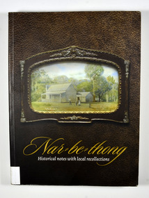
Book, Narbethong-Historical notes with local recollections, 2013
... Marysville & District Historical Society 39 Darwin Street Marysville yarra-valley-and-the-dandenong-ranges A history of Narbethong taken from recollections of local residents narbethong history victoria australia local history Stamp of the Marysville & District / Historical Society Inc / P.O. Box 22 / Marysville 3779 Paperback. Front cover has a photograph of a painting of 'Lucknow', a farm which was owned by the Yeates Family. Back cover has a black and white photograph of a lady standing next to a wooden sign post showing the Acheron ...A history of Narbethong taken from recollections of local residentsPaperback. Front cover has a photograph of a painting of 'Lucknow', a farm which was owned by the Yeates Family. Back cover has a black and white photograph of a lady standing next to a wooden sign post showing the Acheron Way and the distances to Marysville, Warburton, Narbethong and Healesville.Stamp of the Marysville & District / Historical Society Inc / P.O. Box 22 / Marysville 3779narbethong, history, victoria, australia, local history -
 Marysville & District Historical Society
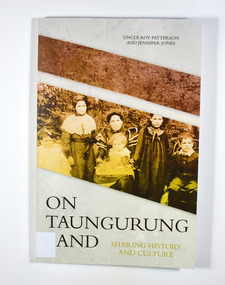
Book, Jennifer Jones et al, On Taungurung Land-Sharing History and Culture, 2020
... Marysville & District Historical Society 39 Darwin Street Marysville yarra-valley-and-the-dandenong-ranges On Taungurung Land: Sharing History and Culture is the first monograph to examine how the Taungurung Nation of central Victoria negotiated with protectors and pastoralists to retain possession of their own country for as long as possible. This book concentrates upon the foundational Aboriginal stations on Taungurung Country-Acheron ...On Taungurung Land: Sharing History and Culture is the first monograph to examine how the Taungurung Nation of central Victoria negotiated with protectors and pastoralists to retain possession of their own country for as long as possible.Front cover has a photograph of the Patterson family c.1904. Back cover has the blurb of the book and information about the authors of the book.non-fictionOn Taungurung Land: Sharing History and Culture is the first monograph to examine how the Taungurung Nation of central Victoria negotiated with protectors and pastoralists to retain possession of their own country for as long as possible.taungurung nation, elder uncle roy patterson, jennifer jones, acheron aboriginal station, mohican aboriginal station, central victoria, history, white settlement -
 Marysville & District Historical Society
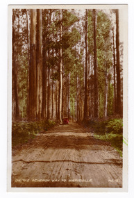
Photograph (item) - Black and white photographs, Valentine Publishing Co. Pty. Ltd, Marysville, Vic, 1923-1963
... valley (image 1)...taggerty river (image 2)...the acheron...After Thomas' death in 1911, his sons Fred and Frank took over the family business and renamed it Barton Bros. the road to cumberland valley (image 1) taggerty river (image 2) the acheron way (image 3) the old ford (image 4) nicholl's lookout (image 5) main street (image 6) mount margaret (image 7) stevenson falls (image 8) cumberland falls (image 9) keppel's falls (image 10) acheron way (image 11) marysville victoria barton bros souvenir valentine publishing co thomas john barton ewen hugh cameron francis adam barton frederick barton A fold-out set of 11 miniature black and white photographs of scenic attractions taken in and around Marysville in Victoria. ...A series of black and white photographs of scenic attractions taken in and around Marysville in Victoria that was published by the Barton Bros, Marysville and printed by Valentines Publishing Co as a souvenir of Marysville.A series of black and white photographs of scenic attractions taken in and around Marysville in Victoria that was published by the Barton Bros, Marysville and printed by Valentines Publishing Co as a souvenir of Marysville. Thomas Barton was one of the earliest settlers in Marysville and with 16 children and numerous descendants the name of Barton is synonymous with Marysville. Thomas John Barton, along with his business partner, Ewen Hugh Cameron, opened a butcher/abattoirs in Marysville in 1864. This was the first shop in Marysville. They supplied meat and other items to the miners along the Woods Point road. Thomas Barton was an active community member and was a key organiser in setting up the school in Marysville in 1870. After Thomas' death in 1911, his sons Fred and Frank took over the family business and renamed it Barton Bros. the road to cumberland valley (image 1), taggerty river (image 2), the acheron way (image 3), the old ford (image 4), nicholl's lookout (image 5), main street (image 6), mount margaret (image 7), stevenson falls (image 8), cumberland falls (image 9), keppel's falls (image 10), acheron way (image 11), marysville, victoria, barton bros, souvenir, valentine publishing co, thomas john barton, ewen hugh cameron, francis adam barton, frederick barton -
 Marysville & District Historical Society
Book, Narbethong-Historical notes with local recollections, 2013
... Marysville & District Historical Society 39 Darwin Street Marysville yarra-valley-and-the-dandenong-ranges A history of Narbethong taken from recollections of local residents narbethong history victoria australia local history Stamp of the Marysville & District / Historical Society Inc / P.O. Box 22 / Marysville 3779 Paperback. Front cover has a photograph of a painting of 'Lucknow', a farm which was owned by the Yeates Family. Back cover has a black and white photograph of a lady standing next to a wooden sign post showing the Acheron ...A history of Narbethong taken from recollections of local residentsPaperback. Front cover has a photograph of a painting of 'Lucknow', a farm which was owned by the Yeates Family. Back cover has a black and white photograph of a lady standing next to a wooden sign post showing the Acheron Way and the distances to Marysville, Warburton, Narbethong and Healesville.Stamp of the Marysville & District / Historical Society Inc / P.O. Box 22 / Marysville 3779narbethong, history, victoria, australia, local history -
 Marysville & District Historical Society
Photograph (item) - Colour tinted photograph, Valentine Publishing Co. Pty. Ltd, On the Acheron Way to Marysville . No.12, 1923-1963
... Marysville & District Historical Society 39 Darwin Street Marysville yarra-valley-and-the-dandenong-ranges An early colour tinted photograph of the Acheron Way near Marysville in Victoria. ...An early colour tinted photograph of the Acheron Way near Marysville in Victoria. This photograph was published by the Valentine Publishing Co Pty. Ltd as a souvenir of Marysville.An early colour tinted photograph of the Acheron Way near Marysville in Victoria. The Acheron Way is an unsealed, winding road that runs from just outside of Marysville to Warburton. This photograph was published by the Valentine Publishing Co Pty. Ltd as a souvenir of Marysville.acheron way, marysville, victoria, valentine publishing co, souvenir, warburton