Showing 19 items matching "aerial navigation"
-
 Moorabbin Air Museum
Book - Aerial navigation, Flight - Meteorology, Aircraft Instruments and Navigation
... Aerial navigation......Aerial navigation...Aerial navigation...Moorabbin Air Museum Moorabbin Airport 12 First Street Moorabbin melbourne Aerial navigation Atmosphere Weather map Airway weather service Aerial photogrophy Aviation radio Aircraft instruments Aerial navigation Overview of basic meteorology , aircraft instrumentation & navigation, circa 1943 Flight - Meteorology, Aircraft Instruments and Navigation Book Aerial navigation ...Overview of basic meteorology , aircraft instrumentation & navigation, circa 1943non-fictionOverview of basic meteorology , aircraft instrumentation & navigation, circa 1943atmosphere, weather map, airway weather service, aerial photogrophy, aviation radio, aircraft instruments, aerial navigation -
Moorabbin Air Museum
Book - Aerial navigation, Air Navigation
... Aerial navigation...Aerial navigation...Aerial navigation Mathematics Maps & charts Time The theory of D.R. navigation Position lines Astronomical navigation Magnetism & compasses Direction finding wireless Tactical navigation Ground organization Applied air navigation Training text for air navigators circa 1941 Air Navigation Book Aerial navigation ...Training text for air navigators circa 1941non-fictionTraining text for air navigators circa 1941mathematics, maps & charts, time, the theory of d.r. navigation, position lines, astronomical navigation, magnetism & compasses, direction finding wireless, tactical navigation, ground organization, applied air navigation -
Moorabbin Air Museum
Book - Aerial navigation, Flightdeck The Story of Air Navigation
... Aerial navigation...Aerial Navigation...Moorabbin Air Museum Moorabbin Airport 12 First Street Moorabbin melbourne Aerial Navigation Navigational aids Airliners Meteorology Flight planning Overview of technical aspects of airliner operation for laymen, circa 1960s Flightdeck The Story of Air Navigation Book Aerial navigation ...Overview of technical aspects of airliner operation for laymen, circa 1960sOverview of technical aspects of airliner operation for laymen, circa 1960snavigational aids, airliners, meteorology, flight planning -
Moorabbin Air Museum
Book - Aerial navigation, The Complete Air Navigator
... Aerial navigation...Aerial navigation...Moorabbin Air Museum Moorabbin Airport 12 First Street Moorabbin melbourne Aerial navigation Background Observational methods General application Overview of the methods of aerial navigation, circa 1954 The Complete Air Navigator Book Aerial navigation ...Overview of the methods of aerial navigation, circa 1954non-fictionOverview of the methods of aerial navigation, circa 1954background, observational methods, general application -
Moorabbin Air Museum
Manual - Aerial navigation, Air Navigation Orders Part 100 Notice to Ground Engineers
... Aerial navigation...Aerial navigation ...Moorabbin Air Museum Moorabbin Airport 12 First Street Moorabbin melbourne Aerial navigation Various orders Collection of air navigation orders issued to civil aviation ground engineers, circa 1947 Air Navigation Orders Part 100 Notice to Ground Engineers Manual Aerial navigation ...Collection of air navigation orders issued to civil aviation ground engineers, circa 1947non-fictionCollection of air navigation orders issued to civil aviation ground engineers, circa 1947various orders -
Moorabbin Air Museum
Book - Aerial navigation, Navigation forA.T.C
... Aerial navigation...Aerial navigation...No publication date stated Navigation forA.T.C Book Aerial navigation ...Overview of the fundamental principles of aerial navigation . No publication date statednon-fictionOverview of the fundamental principles of aerial navigation . No publication date statedair navigation, the earth as a sphere, meridians, latitude & longitude & changes, flat maps, magnetic variation, compass deviation, bearings/courses & tracks, topographical maps, plotting maps, reporting position, the triangle of velocities -
Moorabbin Air Museum
Book - Aerial navigation, Practical Air Navigation
... Aerial navigation...Aerial navigation...Moorabbin Air Museum Moorabbin Airport 12 First Street Moorabbin melbourne Aerial navigation Bearings & courses Effect of wind Velocities Dead reckoning Course & distance calculator Drift Direction finding wireless Cross bearings Attempt to provide overview of aerial navigation in simple terms, circa 1940 Practical Air Navigation Book Aerial navigation ...Attempt to provide overview of aerial navigation in simple terms, circa 1940non-fictionAttempt to provide overview of aerial navigation in simple terms, circa 1940bearings & courses, effect of wind, velocities, dead reckoning, course & distance calculator, drift, direction finding wireless, cross bearings -
 Flagstaff Hill Maritime Museum and Village
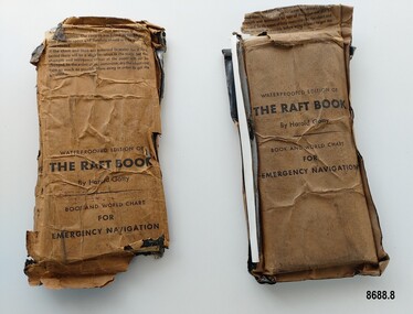
Booklet - Book and World Chart for Emergency Navigation, George Grady Press, The Raft Book, 1943
... ...aerial navigation...At this time he became very interested in air navigation and was aware of the limitations of existing methods and instruments for aerial navigation. He began researching ways of improving aerial navigation. ...At this time he became very interested in air navigation and was aware of the limitations of existing methods and instruments for aerial navigation. He began researching ways of improving aerial navigation. ...Harold Gatty was born on January 5th, 1903 in Campbell Town, Tasmania. He was a navigator and aviation pioneer. He began his career learning navigation at the age of 14 as a midshipman at the Royal Australian Naval College but withdrew after three years and became an apprenticed ship's officer with the Patrick Steamship Company of Sydney. After W. W. 1 he joined the Australian Merchant Navy where he learned the constellations while standing night watch and became an expert in celestial navigation while serving on many ships sailing between Australia and California. In 1927 he moved to California and opened a navigation school and also a laboratory repairing navigational equipment. At this time he became very interested in air navigation and was aware of the limitations of existing methods and instruments for aerial navigation. He began researching ways of improving aerial navigation. Two early inventions of his were his air sextant and a ground speed and drift indicator which formed the basis of the automatic pilot which later came to be standard equipment on most aircraft. He worked with several record breaking pilots including Ann Morrow Lindbergh (who went on to serve as a navigator for her husband Charles Lindbergh), helped Wiley Post break the world record circumnavigating the Earth, invented a new method of "dead reckoning" that revolutionised the ability to fly safely through cloudy conditions without drifting off course and famously navigated a small plane (whilst trying to cross the Pacific) over 1900 km through fog (with no radio) and using only his dead reckoning techniques, back to their starting point in Japan after they developed fuel problems. In 1932 Gatty received the Distinguished Flying Cross from President Hoover. In 1934 Gatty formed the South Seas Commercial Company with Donald Douglas with the aim to deliver air services to the islands of the South Pacific. The Company was sold to Pan Am but he continued to work for them. In 1935 he went on a sailing expedition investigating several small islands in the South Pacific and was briefly marooned on Baker Island. He was able to use his extensive knowledge of seabird habits to save the crew. He was also very interested in the ability of the Polynesians to navigate using the stars. During the Second World War Gatty was given the honorary rank of Group Captain in the Royal Australian Air Force (RAAF) and worked for the U. S. Army Air Forces (USAAF) in the South Pacific. In 1943 he moved to Washington where he developed a survival book (The Raft Book) specifically for boat crews or air crews flying over the Pacific to help them survive and navigate their life rafts in remote areas of the ocean. The original book was 152 pages long however a condensed version was made which consisted of a 64 page booklet, combined map and star chart and calendar strip enclosed in a waterproof slipcase, to be placed in life rafts for emergency use. The booklet included navigational advice and ideas such as ocean currents, estimation of distance, using a compass, measurement of angles, recognising and steering by the stars, land indications from sea birds, migration of sea birds and insects, sounds from the land, the scent of the land and ocean currents and the colour of the sea etc. After W.W.2 Gatty moved to Fiji and formed Fiji Airways (which later became Air Pacific). Harold Gatty died in August 1957.The two copies of "The Raft Book" are significant as they are a written summary of the many methods of sea navigation (both modern and historical) that existed in the 1940's. They are also a record of Harold Gatty, who played a significant role in the development of modern day aerial navigation using his understanding of different sea navigational techniques.Two rectangular brown packets with waterproof coverings (oiled paper) titled "The Raft Book" by Harold Gatty. Each packet contains a folded 64 page paper booklet with detailed instructions for navigating a small craft in open seas, a folded chart (with a map of the world and oceans, well known constellations, latitude and longitude charts, Greenwich time and a scale for string lengths and Harp scale) and a long folded paper calendar strip.Front of package - "WATERPROOFED EDITION OF/ THE RAFT BOOK / By Harold Gatty / BOOK AND WORLD CHART / FOR / EMERGENCY NAVIGATION / To open envelope tear along above line. If the envelope is used again fold the flap to keep contents dry. 1. This envelope contains a book, chart and tape for emergency navigation. The contents are folded to take up the least possible space and therefore should not be removed until needed. 2. if the chart and tape are immersed in water for a long period, there will be a slight variation in the scale but the strength and resistence to tear of the paper will not be changed. In the event of long immersion, dry the chart and tape as much as possible before using in order to in order to get the greatest accuracy in scale. Front of booklet - THE RAFT BOOK / LORE OF THE SEA AND SKY /By Harold Gatty IMPORTANT FOR YOUR SECURITY/Upon abandoning ship you may have to be your own navigator. Take the following pre/cautions for your own safety:/ Carry a good type of pocket watch / keep it wound and have it running on Greenwich (England) / Time, which you can get from the navigating officer. / Keep track of the date at Greenwich; and on a 24-hour basis, / know whether the time is, say, 6 hours (6 A.M.) showing on / your watch, or 18 hours (6P.M.) Greenwich. / PROECT YOUR WATCH. GET A RUBBER SACK FOR IT (OBTAIN FROM PHARMACIST) AND KEEP IT DRY / KEEP A PENCIL IN YOUR POCKET/ POSITION OF SHIP WHEN ABANDONED PRINTED IN UNITED STATES OF AMERICA GEORGE GRADY PRESS, NEW YORK/COPYRIGHT, 1943, BY HAROLD AND FENNA GATTYflagstaff hill maritime museum and village, shipwreck coast, warrnambool, the raft book, harold gatty, book and world chart for emergency navigation, ww 2, ww ii, navigation, air navigation, aerial navigation, lindbergh, wiley post, dead reckoning, south seas commercial company, u.s. army airforce, usaaf, survival book, life rafts, sea navigation, emergency navigation, fiji airways, harp scale -
 Moorabbin Air Museum
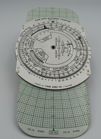
Instrument (item) - Kane Dead Reckoning Computer MK-6B, With Pouch
... Kane Dead Reckoning Computer MK-6B, with pouch, used in aerial navigation....Kane Dead Reckoning Computer MK-6B, with pouch, used in aerial navigation. Kane Dead Reckoning Computer MK-6B, With Pouch. ... -
Moorabbin Air Museum
Book - Instrument Flight, I'd Rather Be Flying Instrument and Multi Engine Flying for the Weekend Pilot
... ...Aerial navigation...Moorabbin Air Museum Moorabbin Airport 12 First Street Moorabbin melbourne Instrument flying Maps Aerial navigation Instruments Overview of instrument flying & change to multi engined aircraft for private pilots, circa 1962 I'd Rather Be Flying Instrument and Multi Engine Flying for the Weekend Pilot Book Instrument Flight ...Overview of instrument flying & change to multi engined aircraft for private pilots, circa 1962non-fictionOverview of instrument flying & change to multi engined aircraft for private pilots, circa 1962maps, aerial navigation, instruments -
 Bendigo Military Museum
Photograph - Royal Australian Survey Corps Aerial Surveys, c1980
... aerial photography. Introduced in 1974–1975, the Magnavox AN/PRR-14 portable Doppler satellite (US Navy Navigation Satellite System – TRANSIT) receivers and computing system provided independent three-dimensional point positions anywhere in the world, anytime, in any weather accurate to about 1.5metres with precise satellite ephemerides. ...aerial photography. Introduced in 1974–1975, the Magnavox AN/PRR-14 portable Doppler satellite (US Navy Navigation Satellite System – TRANSIT) receivers and computing system provided independent three-dimensional point positions anywhere in the world, anytime, in any weather accurate to about 1.5metres with precise satellite ephemerides. ...This is a set of nine photographs of technicians from the Royal Australian Survey Corps operating aerial surveys equipment c1980s. In photo .1P, CPL Steve Gloster was operating a RC10 air survey camera mounted in an Australian Army Pilatus Porter aircraft. The Wild RC10 super wide-angle air survey cameras were first introduced in 1971, were equipped with virtual distortion free lenses for supplementary, spot and special photography. In photo .2P, Roger Rees was operating Air Profile Recorder (APR) equipment. it was possibly taken during OP NERVOSE 84, sometime between June – August 1984 when based in Ngukurr, Northern Territory. The APR was operated at this time in unison with an RC10 camera. In 1963 the Royal Australian Survey Corps introduced the radar airborne profile recorder (Canadian Applied Research Ltd, Mark V, Airborne Profiler Recorder) was introduced for 1:100,000 mapping to replace terrain heighting by aneroid barometry. Later in 1974-1975, the Australian developed WREMAPS II airborne laser terrain profile recorder was introduced. In photo .3P, Neil Jones appears at the door of Airsearch Beechcraft Queen Air aircraft, Registration / Serial VH-MWX. This aircraft was typically used by RA Svy on air survey operations flying mission with Aerodist, APR and RC10 camera equipment. The Australian Army’s Pilatus Porter (short take-off and landing turbo propeller) was also equipped with a Wild RC10 aerial mapping camera for identification photography. The Pilatus Porter was also used on RA Svy’s map field checking operations. Photo .9P was taken at a survey station at an unknown location. In this photo an Australian Army Kiowa Light Observation Helicopter (LOH) is supporting a field survey party undertaking Magnavox AN/PRR-14 portable Doppler satellite observations. The satellite receiver’s antenna is plumbed over the survey ground mark surrounded by white plastic panels. The panels were used to identify the survey station on aerial photography. Introduced in 1974–1975, the Magnavox AN/PRR-14 portable Doppler satellite (US Navy Navigation Satellite System – TRANSIT) receivers and computing system provided independent three-dimensional point positions anywhere in the world, anytime, in any weather accurate to about 1.5metres with precise satellite ephemerides. The Bell OH-58 Kiowa LOH was a family of military helicopters used for observation, utility, and direct fire support. It was identified by RA Svy in the mid-1970s that considerable time was lost in replacing unserviceable remote equipment by road. Therefore Aerodist operations (pre-dating satellite receiver operations) were fully supported by Army’s Kiowa LOH aircraft. This is a set of nine photographs of technicians from the Royal Australian Survey Corps operating aerial surveys equipment c1980s. .1P to .3P, .5P to .9P - Colour and black and white photos on photographic paper and scanned at 300 dpi. .4P - Colour photo on 35mm slide film and scanned at 96 dpi. .1) & .2) - Photo, black & white, c1980s, CPL Steve Gloster operating an RC10 air camera. .3) - Photo, colour, 1984, Roger Rees operating Air Profile Recorder (APR) equipment. .4) - Photo, colour, c1980s, Neil Jones at the door of an Airsearch Beechcraft Queen Air aircraft, typically used by RA Svy on air survey operations. .5) - Photo, colour, c1980s. A Beechcraft King Air aircraft, also used by RA Svy on air survey operations. .6) - Photo, colour, c1980s. An Australian Army Pilatus Porter, used by RA Svy on air survey and map field checking operations. SGT Peter Mustart is possibly in the foreground. .7) to .8) - Photo, colour, c1980s. An Australian Army Pilatus Porter and unidentified personnel, used by RA Svy on air survey and map field checking operations. .9) - Photo, colour, c1980s. An Australian Army Kiowa helicopter supporting a field survey party undertaking Magnavox AN/PRR-14 portable Doppler satellite observations. There are biro marks on photos .4P to .9Proyal australian survey corps, rasvy, army survey regiment, asr, fortuna, aerial surveys -
 Bendigo Military Museum
Photograph - 4th Field Survey Squadron – Operation ARIGHT 93, Queensland, 1993
... navigation and to position remote isolated features. Three Bell Kiowa LOH helicopters provided by 162 Recce Sqn supported field checking operations. Supplementary and Vital Asset Protection photography was taken by air camera operators in AAAvn Nomad aircraft from 173 Survl Sqn fitted with an RC10 aerial camera....navigation and to position remote isolated features. Three Bell Kiowa LOH helicopters provided by 162 Recce Sqn supported field checking operations. Supplementary and Vital Asset Protection photography was taken by air camera operators in AAAvn Nomad aircraft from 173 Survl Sqn fitted with an RC10 aerial camera. ...This is a set of 42 photographs taken during 4th Field Survey Squadron’s deployment on Operation ARIGHT 93 in North Queensland from the 30th of August to the 8th of October 1993. The Survey Field Completion area of operations was Weipa near the top end of the Cape York Peninsula. Survey parties conducted field checking of topographic maps covering Bamaga, Heathlands, Weipa, Lockhart River and Strathgordon in Perentie 110 Series Survey variant FFR Land Rovers. Hand-held Trimble and Magellan GPS receivers were used to assist with navigation and to position remote isolated features. Three Bell Kiowa LOH helicopters provided by 162 Recce Sqn supported field checking operations. Supplementary and Vital Asset Protection photography was taken by air camera operators in AAAvn Nomad aircraft from 173 Survl Sqn fitted with an RC10 aerial camera.This is a set of 42 photographs taken in 1993 durin8g 4th Field Survey Squadron’s deployment on Operation ARIGHT in North Queensland. The colour photographs are on 35mm negative film and are part of the Army Survey Regiment’s Collection. The photographs were scanned at 96 dpi. .1) - Photo, colour, 1993. Survey party in Perentie 110 Series Land Rover navigates through Cape York Peninsula sand hills. .2) - Photo, colour, 1993. Cape York Peninsula sand hills. .3) - Photo, colour, 1993. Cape York Peninsula Island. .4) - Photo, colour, 1993. Survey party in Perentie 110 Series Land Rover enters a Cape York Peninsula beach. .5) - Photo, colour, 1993. SPR Kim Baker takes a break on a Cape York Peninsula beach. .6) - Photo, colour, 1993. L to R: MAJ Andy Cordova (USA Exchange) from the Army Survey Regiment and unidentified civilians. .7) to .14) - Photo, colour, 1993. Cape York Peninsula topography. .15) - Photo, colour, 1993. Unidentified surveyor in Bell Kiowa LOH helicopter. .16) - Photo, colour, 1993. Bell Kiowa LOH helicopter circles base camp. .17) to .18) - Photo, colour, 1993. Cape York Peninsula topography. .19) - Photo, colour, 1993. Vehicle convoy taking a break. L to R: LT John Bath (Detachment OC), unidentified (x2), SPR Chris Pearse. .20) - Photo, colour, 1993. Vehicle convoy taking a break. .21) - Photo, colour, 1993. Vehicle convoy ready to go. SPR Chris Pearse. .22) - Photo, colour, 1993. Vehicle convoy on the move. .23) - Photo, colour, 1993. Cape York Peninsula topography. .24) - Photo, colour, 1993. Unidentified personnel. .25) - Photo, colour, 1993. SGT Neale ‘Tex’ Houston. .26) - Photo, colour, 1993. Ground below a Bell Kiowa LOH helicopter .27) - Photo, colour, 1993. L to R: SPR Mark Sinderberry and CPL Stuart Adrain in a Bell Kiowa LOH helicopter. .28) & .29) - Photo, colour, 1993. Ground below a Bell Kiowa LOH helicopter. .30) - Photo, colour, 1993. Base camp viewed from a Bell Kiowa LOH helicopter. .31) - Photo, colour, 1993. Cape York Peninsula topography in recovery after burn-off. .32) & .33) - Photo, colour, 1993. SPR Kim Baker contemplates crossing this bridge in his Land Rover. .34) - Photo, colour, 1993. SPR Kim Baker takes a break next to a billabong. .35) - Photo, colour, 1993. Survey party in Perentie 110 Series Land Rover crosses a creek. .36) - Photo, colour, 1993. Cape York Peninsula bush fire in distance. .37) - Photo, colour, 1993. Survey party in Perentie 110 Series Land Rover traverses a sand hill. .38) - Photo, colour, 1993. SPR Kim Baker. .39) - Photo, colour, 1993. Cape York Peninsula bush fire. .40) - Photo, colour, 1993. Cape York Peninsula topography. .41) & .42) - Photo, colour, 1993. Cape York Peninsula sand hills..1P to .42P – There are no personnel identified. ‘1993 OP ARIGHT’ annotated on negative sleeve.royal australian survey corps, rasvy, 4 fd svy sqn, op aright 93 -
 Nhill Aviation Heritage Centre
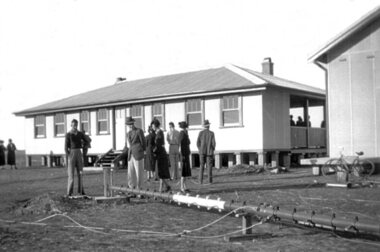
Black and white photograph, Local photograph. Original of this scan held by Nhill Historical Society, Aeradio Building c1937
... navigation for aircraft travelling throughout Australia. The facility closed in the 1960s This photo is significant due to it having been taken soon after the building was constructed. It is the earliest known photograph taken on an open to the public day before the receiver aerials ...This building is still intact at the Nhill Aerodrome. Some of the infrastructure is also in place or can be evidenced by its foundations.The Aeradio building was built on the present aerodrome in 1937. This was one of only sixteen buildings of this type built across Australia and it housed radio communications and guidance equipment. The building and its equipment were part of a comprehensive system of radio towers, signalling and meteorology equipment aimed at providing safer navigation for aircraft travelling throughout Australia. The facility closed in the 1960sThis photo is significant due to it having been taken soon after the building was constructed. It is the earliest known photograph taken on an open to the public day before the receiver aerials were erected.The Aeradio building was built on the present (2012) aerodrome in 1937 or 1938. This was one of only fifteen buildings of this type built across Australia and it housed radio communications and guidance equipment. The building and its equipment were part of a comprehensive system of radio towers lights and signalling equipment aimed at providing safer navigation for aircraft travelling throughout Australia. The facility closed in the 1960sphoto, aeradio, early, civil aviation, dca, dept of civil aviation -
Frankston RSL Sub Branch
Computer, Navigation
... Aerial Dead Reckoning Computer in leather pouch. This device was used as a navigational aid by aircraft pilots and crew. ...Mk 1" Aerial Dead Reckoning Computer in leather pouch. This device was used as a navigational aid by aircraft pilots and crew. ...Aerial Dead Reckoning Computer in leather pouch. This device was used as a navigational aid by aircraft pilots and crew. W&G Aerial Dead Reckoning Computer R.A.A.F. Mk 1 Made in Australia by White & Gillespie Front Scale: Distance Naut Miles, True Air Speed (Time Min, Hrs, Density Altitude, Air Temp ) Back Scale: Wind Correction Angle( True Heading ) The leather pouch has the following printed on the outside "W&G Aerial Dead Reckoning Computer R.A.A.F. Mk 1" -
 Federation University Historical Collection
Photograph - black and white, Cologne Cathedral from the Rhine, c1950
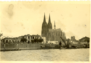
... aerial bombs during World War II. Badly damaged, it nevertheless remained standing in an otherwise completely flattened city. The twin spires were an easily recognizable navigational landmark for Allied aircraft bombing deeper into Germany, which may explain why the cathedral was spared. ...aerial bombs during World War II. Badly damaged, it nevertheless remained standing in an otherwise completely flattened city. The twin spires were an easily recognizable navigational landmark for Allied aircraft bombing deeper into Germany, which may explain why the cathedral was spared. ...Cologne Cathedral is a renowned monument of German Catholicism and Gothic architecture and is a World Heritage Site. It is Germany's most visited landmark, attracting an average of 20,000 people a day. (Wikipedia) Though not targeted itself, the cathedral was very near to the central railway station and suffered fourteen hits by aerial bombs during World War II. Badly damaged, it nevertheless remained standing in an otherwise completely flattened city. The twin spires were an easily recognizable navigational landmark for Allied aircraft bombing deeper into Germany, which may explain why the cathedral was spared. Repairs were completed in 1956. An emergency repair on the northwest tower's base carried out in 1944 using poor-quality brick taken from a nearby ruined building remained visible until 2005 as a reminder of the war, when it was decided to restore the section its original appearance. (Wikipedia) Black and white photograph showing a grand cathedral from a waterway. It is Cologne (Koln) Cathedral from the Rhine. To the left of the photo bombed buildings are evident. The photograph is believed to have been taken by Frank Wright.cologne cathedral, koln, germany, rhine, bombing, world war two, frank wright -
 Lakes Entrance Historical Society
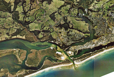
Photograph - Arial View of Lakes Entrance Victoria c2007, 2007c
... Lakes Entrance Historical Society 4 Marine Parade Lakes Entrance gippsland Waterways Navigation Topography Colour aerial photograph of the land forms around the entrance to the Gippsland Lakes, from Kalimna West to Lakes Entrance, North Arm to the ocean. ...Colour aerial photograph of the land forms around the entrance to the Gippsland Lakes, from Kalimna West to Lakes Entrance, North Arm to the ocean. Shows massive sand buildup between Rigby Island and Kalimna, also Bullock Island. Lakes Entrance Victoriawaterways, navigation, topography -
Moorabbin Air Museum
Manual (Item) - Doppler Navigation Equipment (Green Satin) , Comprising Transmitter-Receiver Type 3710, Indicator Electrical Type 101 , TRacking Unit Type 100, Aerial System 501 Bay Servicing Schedule, Doppler Navigation Equipment (Green Satin) Bay Servicing Schedule
... Doppler Navigation Equipment (Green Satin) , Comprising Transmitter-Receiver Type 3710, Indicator Electrical Type 101 , TRacking Unit Type 100, Aerial System 501 Bay Servicing Schedule...Moorabbin Air Museum Moorabbin Airport 12 First Street Moorabbin melbourne AAP 7842.007-6-10 Doppler Navigation Equipment (Green Satin) Bay Servicing Schedule Manual Doppler Navigation Equipment (Green Satin) , Comprising Transmitter-Receiver Type 3710, Indicator Electrical Type 101 , TRacking Unit Type 100, Aerial System 501 Bay Servicing Schedule ...AAP 7842.007-6-10 -
Moorabbin Air Museum
Book - Navigation, The ABC of Practical Astro-Navigation
... Moorabbin Air Museum Moorabbin Airport 12 First Street Moorabbin melbourne Navigation Position lines Practical aero navigation Questions & answers Exercises Text/exercise book on aerial navigation, circa 1946 The ABC of Practical Astro-Navigation Book Navigation ...Text/exercise book on aerial navigation, circa 1946non-fictionText/exercise book on aerial navigation, circa 1946position lines, practical aero navigation, questions & answers, exercises -
Moorabbin Air Museum
Book - Australian aviation year books, Australian Aviation Year Book 1967/68
... Aerial work operators...Charter operators...Ground training colleges...History of Australian aviation...Insurance companies/brokers...RAAF...Radio navigation...Moorabbin Air Museum Moorabbin Airport 12 First Street Moorabbin melbourne Australian aviation year books Aerodromes & airfields Aero clubs & flying schools Approved firms Fleet air arm Aircraft leasing & hire purchase companies Airline operators Aircraft production Aircraft register Aerial work operators Charter operators Ground training colleges History of Australian aviation Insurance companies/brokers RAAF Radio navigation aids Guide to aviation industry throughout Australia & Papua New Guinea Australian Aviation Year Book 1967/68 Book Australian aviation year books ...Guide to aviation industry throughout Australia & Papua New Guineanon-fictionGuide to aviation industry throughout Australia & Papua New Guineaaerodromes & airfields, aero clubs & flying schools, approved firms, fleet air arm, aircraft leasing & hire purchase companies, airline operators, aircraft production, aircraft register, aerial work operators, charter operators, ground training colleges, history of australian aviation, insurance companies/brokers, raaf, radio navigation aids