Showing 3 items matching "aerial photo of camp 3"
-
 Tatura Irrigation & Wartime Camps Museum
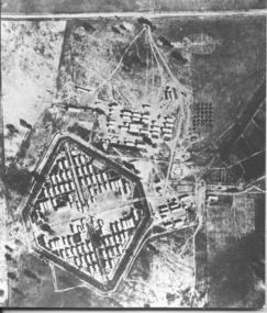
Photograph, Aerial photo of camp 3 1946
... Aerial photo of camp 3 1946...aerial photo of camp 3...Aerial photo of camp 3 1946 Photograph Photograph ...Aerial photograph, taken in 1946 of the Rushworth internment camp.Black and white aerial photograph of camp 3 Rushworth showing layout of the camp.aerial photo of camp 3, taken in 1946, rushworth internment camp, aerial photographs, victorian internment camps -
 Kiewa Valley Historical Society
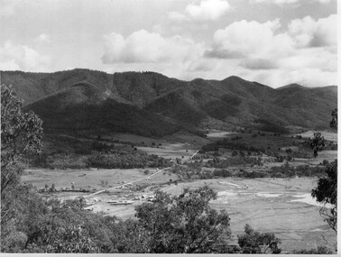
16 Photos - A.N. Barnes Collection
... Aerial photo of Tawonga South; Aerial photo of Tawonga South Aerial view of upper Kiewa Valley Clover P{ower Station / No. 3 Power Station Bogong High Country with snow Bogong Village / Lake Guy Lake Guy dam wall spilling with Bogong Village in background The interior of Lake Guy dam wall Bogong Village at night with lights reflecting in Lake Guy Bogong dam wall overflowing Pretty Valley Camp BHP Road to Rocky Valley The workers' camp at Clover Flat Unknown Two unknown men with a vehicle at the top of the Bright Gap note distance and elevations on sign posts and Royal auto signs on arrows SEC Workmen's Camp ...Kiewa Hudro Electric Scheme A.N.Barnes Aerial photo of Tawonga South; Aerial photo of Tawonga South Aerial view of upper Kiewa Valley Clover P{ower Station / No. 3 Power Station Bogong High Country with snow Bogong Village / Lake Guy Lake Guy dam wall spilling with Bogong Village in background The interior of Lake Guy dam wall Bogong Village at night with lights reflecting in Lake Guy Bogong dam wall overflowing Pretty Valley Camp BHP Road to Rocky Valley The workers' camp at Clover Flat Unknown Two unknown men with a vehicle at the top of the Bright Gap note distance and elevations on sign posts and Royal auto signs on arrows SEC Workmen's Camp 16 Photos - A.N. ...The State Electricity Commission of Victoria constructed the Kiewa Hydro Electric Scheme which included the townships of Bogong and Mount Beauty - from the late 1940s until 1961 The KHES changed the Kiewa Valley from a rural community to a construction community.Aerial photo of Tawonga South; Aerial photo of Tawonga South Aerial view of upper Kiewa Valley Clover P{ower Station / No. 3 Power Station Bogong High Country with snow Bogong Village / Lake Guy Lake Guy dam wall spilling with Bogong Village in background The interior of Lake Guy dam wall Bogong Village at night with lights reflecting in Lake Guy Bogong dam wall overflowing Pretty Valley Camp BHP Road to Rocky Valley The workers' camp at Clover Flat Unknown Two unknown men with a vehicle at the top of the Bright Gap note distance and elevations on sign posts and Royal auto signs on arrows SEC Workmen's Camp kiewa hudro electric scheme, a.n.barnes -
 Charlton Golden Grains Museum Inc
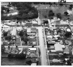
Photograph, Aerial photo of Armstrong St, Charlton, c.1974
... Camp St lower side (from L-R) Court House, Police residence, Police Station, Telecom on corner. The photo is thought to be taken from Ossie Sanderson's airplane in 1974. Armstrong St Charlton Charlton Business Industry Westpac Bank Globe Hotel East Charlton Hotel Dillon Building Black & white aerial photo looking down a broad street that ends in a t-intersection. There is a street that comes off to the left about 1/3 ...Aerial photo looking down Armstrong St. Camp street on the left, Shire Hall on the right. High St runs across the photo. The Avoca River is visible in the top LH side. The swimming pool and bowling green is above the rive. On High St (from L-R) Dr Surgery, H Bath Chemist, Grocery, Roy Dobson, Hairdresser, Stowe's, Westpac Bank (two storey white building), Dillon's Building, Globe Hotel, Charlton Club, butcher shop, Arundell's shoe shop, Watson's Stock & Station Agency, Bullock's grocery, Williams St (Curtin Ave), Bannon's Butchers, East Charlton Hotel, MB Luth & Co, Lou's cafe. The old sale yards are at the end of Williams Street. Camp St lower side (from L-R) Court House, Police residence, Police Station, Telecom on corner. The photo is thought to be taken from Ossie Sanderson's airplane in 1974.Black & white aerial photo looking down a broad street that ends in a t-intersection. There is a street that comes off to the left about 1/3 of the way up the photo. There is a large building directly opposite this street. In the upper right there is a two storey building with arches on its verandah. In the upper LH side there is a swimming pool and bowling greens.armstrong st charlton, charlton, business, industry, westpac bank, globe hotel, east charlton hotel, dillon building