Showing 830 items matching "aerial photos"
-
 Bendigo Military Museum
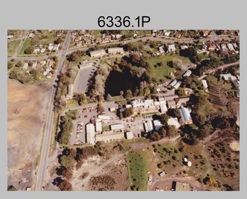
Photograph - Army Survey Regiment aerial photos, Fortuna, Bendigo, 1991
... Army Survey Regiment aerial photos, Fortuna, Bendigo...Army Survey Regiment aerial photos, Fortuna, Bendigo...This is a set of 32 aerial photographs of the Army Survey Regiment, Fortuna, Bendigo taken in 1991. These photos are indicative of a series of over 70 aerial photos in the collection taken from multiple angles and elevations. ...This is a set of 32 colour aerial photographs of the Army Survey Regiment, Fortuna, Bendigo taken in 1991. Photos .1P and .2P are on photographic paper and scanned at 300 dpi. ...Army Survey Regiment aerial photos, Fortuna, Bendigo Photograph Army Survey Regiment aerial photos, Fortuna, Bendigo Army Survey Regiment ...This is a set of 32 aerial photographs of the Army Survey Regiment, Fortuna, Bendigo taken in 1991. These photos are indicative of a series of over 70 aerial photos in the collection taken from multiple angles and elevations. It is possible the photographs were taken from a hot air balloon. The approximate date of the photos is based on the existence of the new printing building - Wazgoose Hall and the new records building.This is a set of 32 colour aerial photographs of the Army Survey Regiment, Fortuna, Bendigo taken in 1991. Photos .1P and .2P are on photographic paper and scanned at 300 dpi. Photos .3P to .32P are on 35mm negative film and scanned at 2400 dpi. They are part of the Army Survey Regiment’s .1) - Photo, colour, 1991. Army Survey Regiment taken from the East. .2) - Photo, colour, 1991. Army Survey Regiment taken from the North. .3) - Photo, colour, 1991. Army Survey Regiment taken from the SSE. .4) - Photo, colour, 1991. Army Survey Regiment taken from the NE. .5) - Photo, colour, 1991. Army Survey Regiment taken from the North. .6) - Photo, colour, 1991. Army Survey Regiment taken from the South. .7) - Photo, colour, 1991. Army Survey Regiment taken from the West. .8) - Photo, colour, 1991. Army Survey Regiment taken from the South. .9) - Photo, colour, 1991. Army Survey Regiment taken from the SSW. .10) - Photo, colour, 1991. Army Survey Regiment taken from the SW. .11) - Photo, colour, 1991. Army Survey Regiment taken from the ESE. .12) - Photo, colour, 1991. Army Survey Regiment taken from the East. .13) - Photo, colour, 1991. Army Survey Regiment taken from the WSW. .14) - Photo, colour, 1991. Army Survey Regiment taken from the SSW. .15) - Photo, colour, 1991. Army Survey Regiment taken from the South. .16) - Photo, colour, 1991. Army Survey Regiment taken from the NNE. .17) - Photo, colour, 1991. Army Survey Regiment taken from the North .18) - Photo, colour, 1991. Army Survey Regiment taken from the SE. .19) - Photo, colour, 1991. Army Survey Regiment taken from the SE. .20) - Photo, colour, 1991. Army Survey Regiment taken from the NNE. .21) - Photo, colour, 1991. Army Survey Regiment taken from the ESE. .22) - Photo, colour, 1991. Army Survey Regiment taken from the ENE. .23) - Photo, colour, 1991. Army Survey Regiment taken from the NE. .24) - Photo, colour, 1991. Army Survey Regiment taken from the North. .25) - Photo, colour, 1991. Army Survey Regiment taken from the NW. .26) - Photo, colour, 1991. Army Survey Regiment taken from the South .27) & 28) - Photo, colour, 1991. Army Survey Regiment taken from the East. .29) - Photo, colour, 1991. Army Survey Regiment taken from the NNW. .30) - Photo, colour, 1991. Army Survey Regiment taken from the WNW .31) & 32) - Photo, colour, 1991. Army Survey Regiment taken from the SE.royal australian survey corps, rasvy, army survey regiment, army svy regt, fortuna, asr -
 Moorabbin Air Museum
Photograph (Item) - Assorted Aerial Photos Of Lae, Rabaul, Horn Island, Kahili, Buna, Gona , Ballale Island
... Assorted Aerial Photos Of Lae, Rabaul, Horn Island, Kahili, Buna, Gona , Ballale Island...Assorted Aerial Photos Of Lae, Rabaul, Horn Island, Kahili, Buna, Gona , Ballale Island...Moorabbin Air Museum Moorabbin Airport 12 First Street Moorabbin melbourne Assorted Aerial Photos Of Lae, Rabaul, Horn Island, Kahili, Buna, Gona , Ballale Island Photograph Assorted Aerial Photos Of Lae, Rabaul, Horn Island, Kahili, Buna, Gona , Ballale Island ... -
 Bendigo Historical Society Inc.
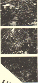
Photograph - LONG GULLY HISTORY GROUP COLLECTION: AERIAL PHOTOS
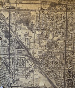
... LONG GULLY HISTORY GROUP COLLECTION: AERIAL PHOTOS...The Long Gully History Group - Aerial Photos...Copies of three dark aerial photos of suburban areas, possibly Long Gully. ...Photograph LONG GULLY HISTORY GROUP COLLECTION: AERIAL PHOTOS ...Copies of three dark aerial photos of suburban areas, possibly Long Gully. Photos show streets and buildings.bendigo, history, long gully history group, the long gully history group - aerial photos -
 Orbost & District Historical Society
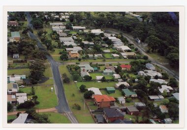
Photograph - Aerial photos of Marlo, early 2000s
... Aerial photos of Marlo ...These three aerial photos are of Marlo, concentrating on the roads and allotments around Jorgensen Street. ...Three aerial colour photos of houses, roads, trees. Three aerial photos taken from slightly different directions. ...Photograph Aerial photos of Marlo ...These three aerial photos are of Marlo, concentrating on the roads and allotments around Jorgensen Street. They were taken from the air in the early 2000s when Sue Neilson's parents were rebuilding their home at 59 Jorgensen Street. Marlo is located at the mouth of the Snowy River in East Gippsland. These photos are significant because they record a show a section of Marlo in the early 2000s. Three aerial colour photos of houses, roads, trees. Three aerial photos taken from slightly different directions. marlo, jorgensen street -
 Stawell Historical Society Inc
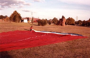
Photograph, Aerial Photos of Stawell from a Hot Air Balloon 1985 -- 12 Photos
... Aerial Photos of Stawell from a Hot Air Balloon 1985 -- 12 Photos...Series of 12 Aerial Photos of Stawell. Hot Air Balloon 1985. ...Series of twelve photos mostly consisting of aerial photos and two of a large balloon on the ground. ...Aerial Photos of Stawell from a Hot Air Balloon 1985 -- 12 Photos Photograph ...Series of 12 Aerial Photos of Stawell. Hot Air Balloon 1985. Photos taken during hot air balloon rides May & June 1935. The rides left from land near leisure complex, Houston St and Newington Rd corner. The rides first over Stawell and drifted towards the Black Range. This vacant site is now the location of Stawell indoor heated and outdoor pools. 1 & 2. Setting up balloon. 3. North Park Area Lamont St. 4. Netball & Tennis courts Athletic track. 5 Wimmera St, Trotting track & Drive-in Scallan St. & Main St. 6. State School 502 Jenning-Campbell & Houston St's. 7 Ligar St. crosses Campbell & Houston St's. 8. Ord St, 502 School yard. 9. Central Park Napier, Wakeham & Shirreff St's also Railway & Foot Bridge. 10. Central Park. 11. Sloane St. on left Trotting track & Drive-in. 12. The Old Lake oval. Series of twelve photos mostly consisting of aerial photos and two of a large balloon on the ground. stawell -
 Whitehorse Historical Society Inc.
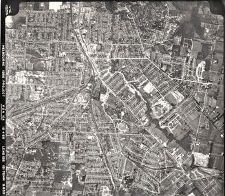
Photograph - Aerial photographs x 10, Miscellaneous Aerial Photos, 1966
... Miscellaneous Aerial Photos...Aerial photos...Whitehorse Historical Society Inc. 2-10 Deep Creek Road Mitcham melbourne 1966 Aerial photographs Aerial photos eastern suburbs 1966 Ten aerial photographs in mainly the Eastern suburbs Miscellaneous Aerial Photos Photograph Aerial photographs x 10 ...1966 Aerial photographsTen aerial photographs in mainly the Eastern suburbsaerial photos, eastern suburbs, 1966 -
Stawell Historical Society Inc
Photograph, Aerial Photos of Stawell from a Hot Air Balloon 1985 -- 11 Photos
... Aerial Photos of Stawell from a Hot Air Balloon 1985 -- 11 Photos...Series of 11 Aerial Photos of Stawell. Hot Air Balloon 1985. ...Series of 11 colour photographs of aerial photos of balloon rides over a town. ...Over Deep Lead. stawell Series of 11 colour photographs of aerial photos of balloon rides over a town. Aerial Photos of Stawell from a Hot Air Balloon 1985 -- 11 Photos Photograph ...Series of 11 Aerial Photos of Stawell. Hot Air Balloon 1985. Photo were taken during a second balloon ride in July 1985. Take off venue was the oval at Stawell West Primary School. The balloon course was parallel to the Western Highway out over Deep Lead. 1. Ride left from Stawell West Primary Oval. 2. School Children were brought out to see the balloon launch. 3. Western Highway Green School oval. 4. Central Park Lower Main St. 5. Taylor's Gully Park Sloane St. 6. Shadow of Hot Air balloon on low cloud over Western Highway. 7. North Western Woollen Mills. 8. Pleasant Creek special school. 9. Looking back at Stawell. 10. Grampians & Lake Lonsdale. 11. Over Deep Lead. Series of 11 colour photographs of aerial photos of balloon rides over a town. stawell -
 Stawell Historical Society Inc
Photograph, Aerial Photos of Stawell
... Aerial Photos of Stawell ...Aerial Photos of Stawell...Stawell Historical Society Inc 46 Longfield St Stawell grampians Aerial Photos of Stawell Stawell Aerial Photos of Stawell Photograph ...Aerial Photos of Stawellstawell -
Tatura Irrigation & Wartime Camps Museum
Photographs, aerial photos of Tatura 1959
... aerial photos of Tatura 1959...Two aerial photos of Tatura 1959...Tatura Irrigation & Wartime Camps Museum 49 Hogan Street Tatura the-murray Two aerial photos of Tatura 1959 2 photos aerial photos of Tatura 1959 Photographs ...Two aerial photos of Tatura 19592 photos -
Stawell Historical Society Inc
Photograph, Aerial Photos of Stawell from a Hot Air Balloon 1992 -- 12 Photos
... Aerial Photos of Stawell from a Hot Air Balloon 1992 -- 12 Photos...Series of 12 Aerial Photos of Stawell. Hot Air Balloon, October 1992 1. ...Stawell Historical Society Inc 46 Longfield St Stawell grampians Series of 12 Aerial Photos of Stawell. Hot Air Balloon, October 1992 1. ...Series of 12 Aerial Photos of Stawell. Hot Air Balloon, October 1992 1. Cnr. Maude St & Grant Street 2. Maude St Napier Street & Railway cutting 3. Trotting Track 4. Roundabout Wimmera & Sloane Street 5. Florence Street towards Cato Lake & Park 6. Grampians Range with Lake Lonsdale near center 7. Gold Reef Mall looking West 8. Church Street looking West 9. Looking towards Black Range 10. Moonie Dams Darlington Road Leisure Complex 11. Stawell Gold Mine Evaporations Dams, Stawell Water Reservoirs, Moonie Dams 12. Darlington Road looking towards Black RangeSeries of 12 colour photographs from the Air.stawell -
 Stawell Historical Society Inc
Photograph, Stawell Cemetery, Aerial View -- 2 Photos -- Coloured
... Stawell Cemetery, Aerial View -- 2 Photos -- Coloured...Stawell Cemetery (Aerial Photos)...Stawell Historical Society Inc 46 Longfield St Stawell grampians Stawell Cemetery (Aerial Photos) Stawell Stawell Cemetery, Aerial View -- 2 Photos -- Coloured Photograph ...Stawell Cemetery (Aerial Photos)stawell -
 Poowong Historical Group
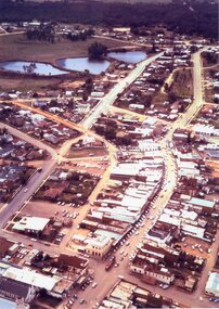
Aerial Photos of Poowong Township 200?
... Aerial Photos of Poowong Township 200?...Poowong Historical Group 35 Nyora Road Poowong Aerial photograph of poowong Football Groung looking North East Aerial Photos of Poowong Township 200? ...Aerial photograph of poowong Football Groung looking North East -
Moorabbin Air Museum
Document (Item) - CAC GAF Fishermens Bend Aerial Photos
... CAC GAF Fishermens Bend Aerial Photos...Moorabbin Air Museum Moorabbin Airport 12 First Street Moorabbin melbourne Document CAC GAF Fishermens Bend Aerial Photos ... -
Moorabbin Air Museum
Photograph (Item) - Includes photos of Commonwealth aircraft Corp aerial photos, CAC photos of Macchi MB326H trainer Bell 206 Kiowa
... Includes photos of Commonwealth aircraft Corp aerial photos...Moorabbin Air Museum Moorabbin Airport 12 First Street Moorabbin melbourne CAC photos of Macchi MB326H trainer Bell 206 Kiowa Photograph Includes photos of Commonwealth aircraft Corp aerial photos ... -
Moorabbin Air Museum
Photograph (item) - 7 aerial photos of the factory, Commonwealth aircraft Corporation
... 7 aerial photos of the factory...Moorabbin Air Museum Moorabbin Airport 12 First Street Moorabbin melbourne Commonwealth aircraft Corporation Photograph 7 aerial photos of the factory ... -
 Sunshine and District Historical Society Incorporated
Photograph - Aerial Photo of Sunshine North 1947 / 1948
... Aerial Photo of Sunshine North 1947 / 1948...Aerial Photo of Sunshine North 1947 / 1948 including Braybrook, Sunshine & Albion just south of Ballarat Rd. ...Aerial Photo of Sunshine North 1947 / 1948...Sunshine North Aerial Photograph Aerial Photo of Sunshine North 1947 / 1948 Aerial Photo of Sunshine North 1947 / 1948 including Braybrook, Sunshine & Albion just south of Ballarat Rd. ...Aerial Photo of Sunshine North 1947 / 1948sunshine north, aerial photograph -
 Sunshine and District Historical Society Incorporated
Photograph - Aerial Photo of Sunshine
... Aerial Photo of Sunshine...Aerial Photo of Sunshine showing Spalding, Nettlefolds, Ambulance Station, Massey Ferguson, Post Office & Sunshine Overpass...Aerial Photo of Sunshine showing Spalding, Nettlefolds, Ambulance Station, Massey Ferguson, Post Office & Sunshine Overpass...Sunshine Aerial Photograph Aerial Photo of Sunshine showing Spalding, Nettlefolds, Ambulance Station, Massey Ferguson, Post Office & Sunshine Overpass Aerial Photo of Sunshine showing Spalding, Nettlefolds, Ambulance Station, Massey Ferguson, Post Office & Sunshine Overpass Photograph Aerial Photo of Sunshine ...Aerial Photo of Sunshine showing Spalding, Nettlefolds, Ambulance Station, Massey Ferguson, Post Office & Sunshine Overpasssunshine, aerial photograph -
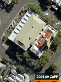 Port Melbourne Historical & Preservation Society
Photograph - Port Melbourne Town Hall - aerial photo Sep 2004, Sep 2004
... Port Melbourne Town Hall - aerial photo Sep 2004...Port Melbourne Town Hall - aerial photo...Port Melbourne Town Hall aerial photo Sep 2004...Port Melbourne Town Hall - aerial photo Port Melbourne Town Hall Built Environment - Civic Port Melbourne Town Hall aerial photo Sep 2004 Photograph Port Melbourne Town Hall - aerial photo Sep 2004 ...Port Melbourne Town Hall - aerial photoPort Melbourne Town Hall aerial photo Sep 2004port melbourne town hall, built environment - civic -
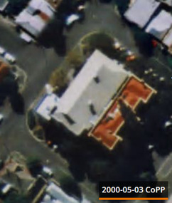 Port Melbourne Historical & Preservation Society
Photograph - Port Melbourne Town Hall - aerial photo 3 May 2000, 3 May 2000
... Port Melbourne Town Hall - aerial photo 3 May 2000...Port Melbourne Town Hall - aerial photo...Port Melbourne Town Hall aerial photo 3 May 2000...Port Melbourne Town Hall - aerial photo Port Melbourne Town Hall Built Environment - Civic Port Melbourne Town Hall aerial photo 3 May 2000 Photograph Port Melbourne Town Hall - aerial photo 3 May 2000 ...Port Melbourne Town Hall - aerial photoPort Melbourne Town Hall aerial photo 3 May 2000port melbourne town hall, built environment - civic -
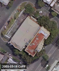 Port Melbourne Historical & Preservation Society
Photograph - Port Melbourne Town Hall - aerial photo 18 Mar 2003, 18 Mar 2003
... Port Melbourne Town Hall - aerial photo 18 Mar 2003...Port Melbourne Town Hall - aerial photo...Port Melbourne Town Hall aerial photo 18 Mar 2003...Port Melbourne Town Hall - aerial photo Port Melbourne Town Hall Built Environment - Civic Port Melbourne Town Hall aerial photo 18 Mar 2003 Photograph Port Melbourne Town Hall - aerial photo 18 Mar 2003 ...Port Melbourne Town Hall - aerial photoPort Melbourne Town Hall aerial photo 18 Mar 2003port melbourne town hall, built environment - civic -
Whitehorse Historical Society Inc.
Article, Blackburn North, 2013
... Agent: Woodards. Aerial photo....Agent: Woodards. Aerial photo....Agent: Woodards. Aerial photo. Blackburn North Article Article ...Real estate advertisement for former orchard block of land in Blackburn North.Real estate advertisement for former orchard block of land in Blackburn North. Agent: Woodards. Aerial photo.Real estate advertisement for former orchard block of land in Blackburn North. surrey road blackburn north, no. 59-67, cock, herbert, junction road blackburn north -
Greensborough Historical Society
Photograph - Aerial Photograph, Watsonia 1945, 1945
... Aerial black and white photo of Watsonia 1945...Black and white aerial photo...Aerial black and white photo of Watsonia 1945 Watsonia aerial 1945 aerial photograph Black and white aerial photo Watsonia 1945 Photograph Aerial Photograph ...Aerial black and white photo of Watsonia 1945Black and white aerial photowatsonia, aerial 1945, aerial photograph -
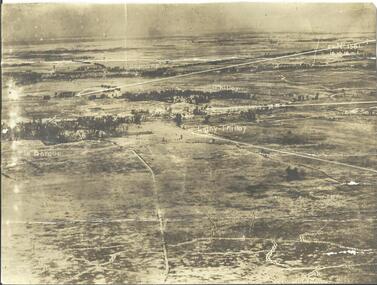
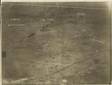 Warrnambool RSL Sub Branch
AERIAL PHOTOGRAPH, (Oblique shot of battlefield) 30/9/1916, LE BARQUE...... LIGNY THILLOY....... THILLOY, 22.N.1514
Original Item recovered from possibly Australian Corps HQ, probably between the Armistice, 11 November 1918, and June 1919, when the Staff Sergeant R.O.(Bob) Snape was repatriated.Sepia photograph, showing trench lines, gun emplacements, landscape peppered with shell craters.snape collection -
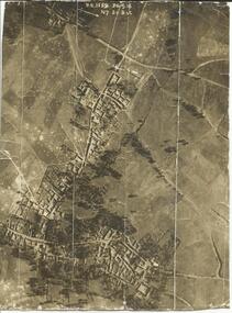 Warrnambool RSL Sub Branch
AERIAL PHOTOGRAPH, (Vertical shot of battle field, shelled/bombed out village) 30/9/1916, 3.C.1159, N7. 20.B &C
Original Item recovered from possibly Australian Corps HQ, probably between the Armistice, 11 November 1918, and June 1919, when the Staff Sergeant R.O.(Bob) Snape was repatriated.Sepia photograph showing shelled/bombed out village with all roofs blown in.snape collection -
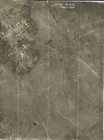 Warrnambool RSL Sub Branch
AERIAL PHOTOGRAPH, (Oblique shot of battle field, with shelled/bombed out vilage) 30/9/1916, 3.C.1151, N.26. 6d. 25d
Original Item recovered from possibly Australian Corps HQ, probably between the Armistice, 11 November 1918, and June 1919, when the Staff Sergeant R.O.(Bob) Snape was repatriated.snape collection -
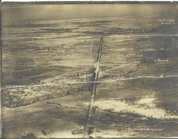 Warrnambool RSL Sub Branch
AERIAL PHOTOGRAPH, (Oblique shot of battlefield from Butte de Warlencourt, wrecked tank featured) 16/10/1916
snape collection -
 Warrnambool RSL Sub Branch
Le Barque, Butte de Warlencourt, 22.N.1561, 16 Oct 1916
snape collection -
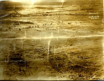 Warrnambool RSL Sub Branch
Ligny Thilloy, Thilloy, Bapaume, Bancourt. 22.N.1559, 16 Oct 1916
snape collection