Showing 295 items matching "aerial surveys"
-
 Bendigo Military Museum
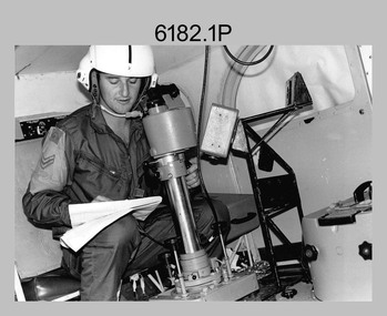
Photograph - Royal Australian Survey Corps Aerial Surveys, c1980
... Royal Australian Survey Corps Aerial Surveys...Royal Australian Survey Corps Aerial Surveys...Survey Regiment...ASR...Fortuna...aerial...This is a set of nine photographs of technicians from the Royal Australian Survey Corps operating aerial surveys equipment c1980s. In photo .1P, CPL Steve Gloster was operating a RC10 air survey camera mounted in an Australian Army Pilatus Porter aircraft. ...This is a set of nine photographs of technicians from the Royal Australian Survey Corps operating aerial surveys equipment c1980s. .1P to .3P, .5P to .9P - Colour and black and white photos on photographic paper and scanned at 300 dpi. .4P - Colour photo on 35mm slide film and scanned at 96 dpi. .1) & .2) - Photo, black & white, c1980s, CPL Steve Gloster operating an RC10 air camera. .3) - Photo, colour, 1984, Roger Rees operating Air Profile Recorder (APR) equipment. .4) - Photo, colour, c1980s, Neil Jones at the door of an Airsearch Beechcraft Queen Air aircraft, typically used by RA Svy on air survey operations. .5) - Photo, colour, c1980s. ...Royal Australian Survey Corps Aerial Surveys Photograph Royal Australian Survey Corps Aerial Surveys Army Survey Regiment ...This is a set of nine photographs of technicians from the Royal Australian Survey Corps operating aerial surveys equipment c1980s. In photo .1P, CPL Steve Gloster was operating a RC10 air survey camera mounted in an Australian Army Pilatus Porter aircraft. The Wild RC10 super wide-angle air survey cameras were first introduced in 1971, were equipped with virtual distortion free lenses for supplementary, spot and special photography. In photo .2P, Roger Rees was operating Air Profile Recorder (APR) equipment. it was possibly taken during OP NERVOSE 84, sometime between June – August 1984 when based in Ngukurr, Northern Territory. The APR was operated at this time in unison with an RC10 camera. In 1963 the Royal Australian Survey Corps introduced the radar airborne profile recorder (Canadian Applied Research Ltd, Mark V, Airborne Profiler Recorder) was introduced for 1:100,000 mapping to replace terrain heighting by aneroid barometry. Later in 1974-1975, the Australian developed WREMAPS II airborne laser terrain profile recorder was introduced. In photo .3P, Neil Jones appears at the door of Airsearch Beechcraft Queen Air aircraft, Registration / Serial VH-MWX. This aircraft was typically used by RA Svy on air survey operations flying mission with Aerodist, APR and RC10 camera equipment. The Australian Army’s Pilatus Porter (short take-off and landing turbo propeller) was also equipped with a Wild RC10 aerial mapping camera for identification photography. The Pilatus Porter was also used on RA Svy’s map field checking operations. Photo .9P was taken at a survey station at an unknown location. In this photo an Australian Army Kiowa Light Observation Helicopter (LOH) is supporting a field survey party undertaking Magnavox AN/PRR-14 portable Doppler satellite observations. The satellite receiver’s antenna is plumbed over the survey ground mark surrounded by white plastic panels. The panels were used to identify the survey station on aerial photography. Introduced in 1974–1975, the Magnavox AN/PRR-14 portable Doppler satellite (US Navy Navigation Satellite System – TRANSIT) receivers and computing system provided independent three-dimensional point positions anywhere in the world, anytime, in any weather accurate to about 1.5metres with precise satellite ephemerides. The Bell OH-58 Kiowa LOH was a family of military helicopters used for observation, utility, and direct fire support. It was identified by RA Svy in the mid-1970s that considerable time was lost in replacing unserviceable remote equipment by road. Therefore Aerodist operations (pre-dating satellite receiver operations) were fully supported by Army’s Kiowa LOH aircraft. This is a set of nine photographs of technicians from the Royal Australian Survey Corps operating aerial surveys equipment c1980s. .1P to .3P, .5P to .9P - Colour and black and white photos on photographic paper and scanned at 300 dpi. .4P - Colour photo on 35mm slide film and scanned at 96 dpi. .1) & .2) - Photo, black & white, c1980s, CPL Steve Gloster operating an RC10 air camera. .3) - Photo, colour, 1984, Roger Rees operating Air Profile Recorder (APR) equipment. .4) - Photo, colour, c1980s, Neil Jones at the door of an Airsearch Beechcraft Queen Air aircraft, typically used by RA Svy on air survey operations. .5) - Photo, colour, c1980s. A Beechcraft King Air aircraft, also used by RA Svy on air survey operations. .6) - Photo, colour, c1980s. An Australian Army Pilatus Porter, used by RA Svy on air survey and map field checking operations. SGT Peter Mustart is possibly in the foreground. .7) to .8) - Photo, colour, c1980s. An Australian Army Pilatus Porter and unidentified personnel, used by RA Svy on air survey and map field checking operations. .9) - Photo, colour, c1980s. An Australian Army Kiowa helicopter supporting a field survey party undertaking Magnavox AN/PRR-14 portable Doppler satellite observations. There are biro marks on photos .4P to .9Proyal australian survey corps, rasvy, army survey regiment, asr, fortuna, aerial surveys -
 Glenelg Shire Council Cultural Collection
Photograph - Photograph - aerial view of railway between Heywood and Rennick, 03/05/1952
... Black and white aerial photographs (aerial survey record print) of the railway line between Heywood and Rennick (S.A. border) Taken for Victorian Railways, May 1952. ...Victorian Railways aerial survey record print of the railway line between Heywood and Rennick (S.A. border) Black and white, white vertical strip on image...Back: 'Heywood - Rennick 21389 - 19660 261m 3c ' - all black ink. Purple VR aerial survey stamp. '3 May 1952' - black stamp...Some photos have annotations later added to the front of the image in pen Victorian Railways train track transport Back: 'Heywood - Rennick 21389 - 19660 261m 3c ' - all black ink. Purple VR aerial survey stamp. '3 May 1952' - black stamp Victorian Railways aerial survey record print of the railway line between Heywood and Rennick (S.A. border) Black and white, white vertical strip on image Photograph Photograph - aerial view of railway between Heywood and Rennick ...Black and white aerial photographs (aerial survey record print) of the railway line between Heywood and Rennick (S.A. border) Taken for Victorian Railways, May 1952. Some photos have annotations later added to the front of the image in penVictorian Railways aerial survey record print of the railway line between Heywood and Rennick (S.A. border) Black and white, white vertical strip on imageBack: 'Heywood - Rennick 21389 - 19660 261m 3c ' - all black ink. Purple VR aerial survey stamp. '3 May 1952' - black stampvictorian railways, train track, transport -
Glenelg Shire Council Cultural Collection
Photograph - Photograph - aerial view of train track between Heywood and Rennick, 03/05/1952
... Black and white aerial photographs (aerial survey record print) of the railway line between Heywood and Rennick (S.A. border) Taken for Victorian Railways, May 1952. ...Victorian Railways aerial survey record print of the railway line between Heywood and Rennick (S.A. border) Black and white, white vertical strip on image...Back: 'Heywood - Rennick 21453 - 19724 267m 19c ' - all black ink. Purple VR aerial survey stamp. '3 May 1952' - black stamp...Some photos have annotations later added to the front of the image in pen Victorian Railways train track transport travel Back: 'Heywood - Rennick 21453 - 19724 267m 19c ' - all black ink. Purple VR aerial survey stamp. '3 May 1952' - black stamp Victorian Railways aerial survey record print of the railway line between Heywood and Rennick (S.A. border) Black and white, white vertical strip on image Photograph Photograph - aerial view of train track between Heywood and Rennick ...Black and white aerial photographs (aerial survey record print) of the railway line between Heywood and Rennick (S.A. border) Taken for Victorian Railways, May 1952. Some photos have annotations later added to the front of the image in penVictorian Railways aerial survey record print of the railway line between Heywood and Rennick (S.A. border) Black and white, white vertical strip on imageBack: 'Heywood - Rennick 21453 - 19724 267m 19c ' - all black ink. Purple VR aerial survey stamp. '3 May 1952' - black stampvictorian railways, train track, transport, travel -
Glenelg Shire Council Cultural Collection
Photograph - Photograph - aerial view of train track between Heywood and Rennick, 03/05/1952
... Black and white aerial photographs (aerial survey record print) of the railway line between Heywood and Rennick (S.A. border) Taken for Victorian Railways, May 1952. ...Victorian Railways aerial survey record print of the railway line between Heywood and Rennick (S.A. border) Black and white, white vertical strip on image...Front: Annotations in red ink added at a later date Back: 'Heywood - Rennick 21579 - 19842 279m 57c ' - all black ink. Purple VR aerial survey stamp. '3 May 1952' - black stamp...Some photos have annotations later added to the front of the image in pen Victorian Railways train track transport travel Front: Annotations in red ink added at a later date Back: 'Heywood - Rennick 21579 - 19842 279m 57c ' - all black ink. Purple VR aerial survey stamp. '3 May 1952' - black stamp Victorian Railways aerial survey record print of the railway line between Heywood and Rennick (S.A. border) Black and white, white vertical strip on image Photograph Photograph - aerial view of train track between Heywood and Rennick ...Black and white aerial photographs (aerial survey record print) of the railway line between Heywood and Rennick (S.A. border) Taken for Victorian Railways, May 1952. Some photos have annotations later added to the front of the image in penVictorian Railways aerial survey record print of the railway line between Heywood and Rennick (S.A. border) Black and white, white vertical strip on imageFront: Annotations in red ink added at a later date Back: 'Heywood - Rennick 21579 - 19842 279m 57c ' - all black ink. Purple VR aerial survey stamp. '3 May 1952' - black stampvictorian railways, train track, transport, travel -
Glenelg Shire Council Cultural Collection
Photograph - aerial view of train track between Heywood and Rennick, 03/05/1952
... Black and white aerial photographs (aerial survey record print) of the railway line between Heywood and Rennick (S.A. border) Taken for Victorian Railways, May 1952. ...Victorian Railways aerial survey record print of the railway line between Heywood and Rennick (S.A. border) Black and white, white vertical strip on image...Front: Annotations in red ink added at a later date Back: 'Heywood - Rennick 21578 - 19841 279m 49c Rennick ' - all black ink. Purple VR aerial survey stamp. '3 May 1952' - black stamp...Some photos have annotations later added to the front of the image in pen Victorian Railways train track travel transport Front: Annotations in red ink added at a later date Back: 'Heywood - Rennick 21578 - 19841 279m 49c Rennick ' - all black ink. Purple VR aerial survey stamp. '3 May 1952' - black stamp Victorian Railways aerial survey record print of the railway line between Heywood and Rennick (S.A. border) Black and white, white vertical strip on image Photograph aerial view of train track between Heywood and Rennick ...Black and white aerial photographs (aerial survey record print) of the railway line between Heywood and Rennick (S.A. border) Taken for Victorian Railways, May 1952. Some photos have annotations later added to the front of the image in penVictorian Railways aerial survey record print of the railway line between Heywood and Rennick (S.A. border) Black and white, white vertical strip on imageFront: Annotations in red ink added at a later date Back: 'Heywood - Rennick 21578 - 19841 279m 49c Rennick ' - all black ink. Purple VR aerial survey stamp. '3 May 1952' - black stampvictorian railways, train track, travel, transport -
Glenelg Shire Council Cultural Collection
Photograph - Photograph - aerial view of the train track between Heywood and Rennick, 03/05/1952
... Black and white aerial photographs (aerial survey record print) of the railway line between Heywood and Rennick (S.A. border) Taken for Victorian Railways, May 1952. ...Victorian Railways aerial survey record print of the railway line between Heywood and Rennick (S.A. border) Black and white, white vertical strip on image...White sticker, black print 'Rennick' Purple VR aerial survey stamp. '3 May 1952' - black stamp...White sticker, black print 'Rennick' Purple VR aerial survey stamp. '3 May 1952' - black stamp Victorian Railways aerial survey record print of the railway line between Heywood and Rennick (S.A. border) Black and white, white vertical strip on image Photograph Photograph - aerial view of the train track between Heywood and Rennick ...Black and white aerial photographs (aerial survey record print) of the railway line between Heywood and Rennick (S.A. border) Taken for Victorian Railways, May 1952. Some photos have annotations later added to the front of the image in penVictorian Railways aerial survey record print of the railway line between Heywood and Rennick (S.A. border) Black and white, white vertical strip on imageFront: Annotations in red ink added at a later date Back: 'Heywood - Rennick 21577 - 19840 279m 41c ' - all black ink. White sticker, black print 'Rennick' Purple VR aerial survey stamp. '3 May 1952' - black stampvictorian railways, travel, train, transport -
 Bendigo Historical Society Inc.
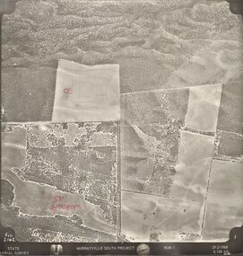
Photograph - MURRAYVILLE SOUTH PROJECT
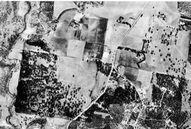
... ... State Aerial Survey...State Aerial Survey. A set of aerial surveys related to the Murrayville South Project. ...A set of aerial surveys related to the Murrayville South Project. ...BHS CollectionState Aerial Survey. A set of aerial surveys related to the Murrayville South Project. Run 1. Vic. 2162. 29-2-1968. 53 photos.photograph, aerial, murrayville south project, photos, murrayville south project, state aerial survey, surveys, murrayville, photographs, photography, aerial photography -
 Greensborough Historical Society
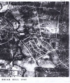
Aerial Photograph, Briar Hill 1945, 1945_
... Aerial survey photograph of Briar Hill area produced in 1945...2 photocopies of aerial surveys...Greensborough Historical Society 34A Glenauburn Road Lower Plenty Lower Plenty melbourne Aerial survey photograph of Briar Hill area produced in 1945 briar hill 2 photocopies of aerial surveys Briar Hill 1945 Aerial Photograph ...Aerial survey photograph of Briar Hill area produced in 19452 photocopies of aerial surveysbriar hill -
 Greensborough Historical Society
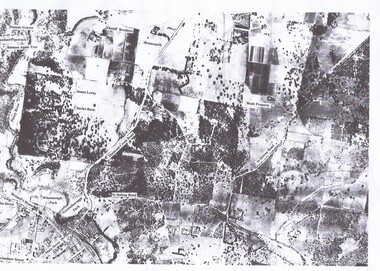
Aerial Photograph, St Helena 1945, 1945_
... Aerial survey photograph of St. Helena Road area of Greensborough...3 copies, various enlargements of aerial survey...Greensborough Historical Society 34A Glenauburn Road Lower Plenty Lower Plenty melbourne Aerial survey photograph of St. Helena Road area of Greensborough greensborough st helena st helena road 3 copies, various enlargements of aerial survey St Helena 1945 Aerial Photograph ...Aerial survey photograph of St. Helena Road area of Greensborough3 copies, various enlargements of aerial surveygreensborough, st helena, st helena road -
 Greensborough Historical Society
Aerial Photograph, Flintoff land - View from above, 1945_
... Section of the 1945 Greensborough aerial survey, focusing on the land belonging to the Flintoff family...Photocopy of section of 1945 aerial survey of Greensborough area...Greensborough Historical Society 34A Glenauburn Road Lower Plenty Lower Plenty melbourne Section of the 1945 Greensborough aerial survey, focusing on the land belonging to the Flintoff family flintoff family aerial photograph "Flintoff land to west of Diamond Creek Rd" written in pencil on back Photocopy of section of 1945 aerial survey of Greensborough area Flintoff land - View from above Aerial Photograph ...Section of the 1945 Greensborough aerial survey, focusing on the land belonging to the Flintoff familyPhotocopy of section of 1945 aerial survey of Greensborough area"Flintoff land to west of Diamond Creek Rd" written in pencil on backflintoff family, aerial photograph -
 Greensborough Historical Society
Aerial Photograph, Watsonia North 1945, 1945_
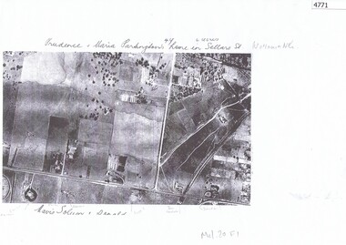
... Part of 1945 aerial survey, area of Watsonia North, including Grimshaw Street, Sellars Street and Macorna Street, indicating the home of Prudence and Maria Partington in Sellars Street....Photocopy of part 1945 aerial survey...Watsonia North" Photocopy of part 1945 aerial survey Watsonia North 1945 Aerial Photograph ...Part of 1945 aerial survey, area of Watsonia North, including Grimshaw Street, Sellars Street and Macorna Street, indicating the home of Prudence and Maria Partington in Sellars Street.Photocopy of part 1945 aerial survey"Prudence and Maria Partington's home in Sellars St. Watsonia North"watsonia north, partington family -
 Peterborough History Group
Map - Government map, Government Printer, Port campbell, 1957
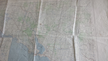
... ...aerial survey map...Aerial survey map showing roads, vegetation and other landscape features....Original 1957 State Aerial Survey Map of Port Campbell region, including Peterborough...Significant because it shows the detail of the region in 1957 peterborough aerial survey map maps Port Campell Original 1957 State Aerial Survey Map of Port Campbell region, including Peterborough Port campbell Map Government map Government Printer ...Aerial survey map showing roads, vegetation and other landscape features.Significant because it shows the detail of the region in 1957Original 1957 State Aerial Survey Map of Port Campbell region, including Peterboroughpeterborough, aerial survey map, maps, port campell -
 Greensborough Historical Society
Aerial Photograph, Greenhills Aerial View, 1945_
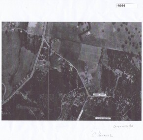
... Section from the 1945 aerial survey of Greensborough, including part of Diamond Creek Road, Greenhill Road, Crest Street and Albion Crescent....Photocopy of part of 1945 aerial survey. Some streets have been marked....Greensborough Historical Society 34A Glenauburn Road Lower Plenty Lower Plenty melbourne Section from the 1945 aerial survey of Greensborough, including part of Diamond Creek Road, Greenhill Road, Crest Street and Albion Crescent. greenhills Photocopy of part of 1945 aerial survey. ...Section from the 1945 aerial survey of Greensborough, including part of Diamond Creek Road, Greenhill Road, Crest Street and Albion Crescent.Photocopy of part of 1945 aerial survey. Some streets have been marked.greenhills -
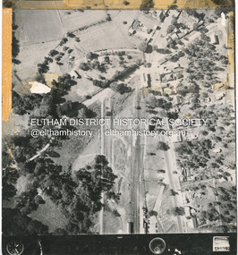 Eltham District Historical Society Inc
Photograph - Aerial Photograph, Main Road and Anzac Ave intersection, Hurstbridge, 12 Apr. 1954
... Victorian Railways Aerial Survey...Stamped VR Aerial Survey This print is not rectified Scale Approx 160' to 1 inch Date Photographed 12.4.54 Written Series 33, Item 9...Eltham District Historical Society Inc 728 Main Rd Eltham melbourne Victorian Railways Aerial Survey shire of eltham archives Aerial Photo Main Road Anzac Avenue Hursbridge Parker Road Hurstbridge Railway Station Rose Road Stamped VR Aerial Survey This print is not rectified Scale Approx 160' to 1 inch Date Photographed 12.4.54 Written Series 33, Item 9 Black and white proto print; Size: 230x240 mm Condition: fair, sticky tape Main Road and Anzac Ave intersection, Hurstbridge Photograph Aerial Photograph ...Victorian Railways Aerial SurveyStamped VR Aerial Survey This print is not rectified Scale Approx 160' to 1 inch Date Photographed 12.4.54 Written Series 33, Item 9shire of eltham archives, aerial photo, main road, anzac avenue, hursbridge, parker road, hurstbridge railway station, rose road -
Glenelg Shire Council Cultural Collection
Photograph - Photograph - aerial view of railway line between Heywood and Rennick, 03/05/1952
... Victorian Railways aerial survey record print of the railway line between Heywood and Rennick (S.A. border) Black and white, white vertical strip on image...Back: 'Heywood - Rennick 21394 - 19665 261m 42c ' - all black ink. Purple VR aerial survey stamp. '3 May 1952' - black stamp...Victorian Railways Heywood Rennick aerial photography Back: 'Heywood - Rennick 21394 - 19665 261m 42c ' - all black ink. Purple VR aerial survey stamp. '3 May 1952' - black stamp Victorian Railways aerial survey record print of the railway line between Heywood and Rennick (S.A. border) Black and white, white vertical strip on image Photograph Photograph - aerial view of railway line between Heywood and Rennick ...From a series of photographs taken for Victorian Railways in 1952.Back: 'Heywood - Rennick 21394 - 19665 261m 42c ' - all black ink. Purple VR aerial survey stamp. '3 May 1952' - black stampvictorian railways, heywood, rennick, aerial photography -
Glenelg Shire Council Cultural Collection
Photograph - Photograph - Aerial Photo railway line between Heywood and Rennick, 03/05/1952
... Victorian Railways aerial survey record print of the railway line between Heywood and Rennick (S.A. border) Black and white, white vertical strip on image...Back: 'Heywood - Rennick 21357 - 19628 258m 16c' - all black ink. Purple VR aerial survey stamp. '3 May 1952' - black stamp...Glenelg Shire Council Cultural Collection History House Cliff Street Portland great-ocean-road Back: 'Heywood - Rennick 21357 - 19628 258m 16c' - all black ink. Purple VR aerial survey stamp. '3 May 1952' - black stamp Victorian Railways aerial survey record print of the railway line between Heywood and Rennick (S.A. border) Black and white, white vertical strip on image Photograph Photograph - Aerial Photo railway line between Heywood and Rennick ...Victorian Railways aerial survey record print of the railway line between Heywood and Rennick (S.A. border) Black and white, white vertical strip on imageBack: 'Heywood - Rennick 21357 - 19628 258m 16c' - all black ink. Purple VR aerial survey stamp. '3 May 1952' - black stamp -
Glenelg Shire Council Cultural Collection
Photograph - Aerial Survey Railway Record Print – 1952, 03/05/1952
... Aerial Survey Railway Record Print – 1952...Victorian Railways aerial survey record print of the railway line between Heywood and Rennick (S.A. border) Black and white, white vertical strip on image....Back: 'Heywood - Rennick 21072 - 19363 235m44c Heywood' - all black ink. Purple VR aerial survey stamp. '3 May 1952' - black stamp...Photograph Aerial Survey Railway Record Print – 1952 ...Victorian Railways aerial survey record print of the railway line between Heywood and Rennick (S.A. border) Black and white, white vertical strip on image.Back: 'Heywood - Rennick 21072 - 19363 235m44c Heywood' - all black ink. Purple VR aerial survey stamp. '3 May 1952' - black stamp -
Glenelg Shire Council Cultural Collection
Photograph - Photograph - Aerial Photo railway line between Heywood and Rennick, 03/05/1952
... Victorian Railways aerial survey record print of the railway line between Heywood and Rennick (S.A. border) Black and white, white vertical strip on image...Back: 'Heywood - Rennick 21395 - 19666 261m 49c ' - all black ink. Purple VR aerial survey stamp. '3 May 1952' - black stamp...Glenelg Shire Council Cultural Collection History House Cliff Street Portland great-ocean-road Back: 'Heywood - Rennick 21395 - 19666 261m 49c ' - all black ink. Purple VR aerial survey stamp. '3 May 1952' - black stamp Victorian Railways aerial survey record print of the railway line between Heywood and Rennick (S.A. border) Black and white, white vertical strip on image Photograph Photograph - Aerial Photo railway line between Heywood and Rennick ...Victorian Railways aerial survey record print of the railway line between Heywood and Rennick (S.A. border) Black and white, white vertical strip on imageBack: 'Heywood - Rennick 21395 - 19666 261m 49c ' - all black ink. Purple VR aerial survey stamp. '3 May 1952' - black stamp -
Glenelg Shire Council Cultural Collection
Photograph - Photograph - Aerial Photo railway line between Heywood and Rennick, 03/05/1952
... Victorian Railways aerial survey record print of the railway line between Heywood and Rennick (S.A. border) Black and white, white vertical strip on image...Back: 'Heywood - Rennick 21385 - 19656 260m 53c' - all black ink. Purple VR aerial survey stamp. '3 May 1952' - black stamp...Glenelg Shire Council Cultural Collection History House Cliff Street Portland great-ocean-road Back: 'Heywood - Rennick 21385 - 19656 260m 53c' - all black ink. Purple VR aerial survey stamp. '3 May 1952' - black stamp Victorian Railways aerial survey record print of the railway line between Heywood and Rennick (S.A. border) Black and white, white vertical strip on image Photograph Photograph - Aerial Photo railway line between Heywood and Rennick ...Victorian Railways aerial survey record print of the railway line between Heywood and Rennick (S.A. border) Black and white, white vertical strip on imageBack: 'Heywood - Rennick 21385 - 19656 260m 53c' - all black ink. Purple VR aerial survey stamp. '3 May 1952' - black stamp -
Glenelg Shire Council Cultural Collection
Photograph - Photograph - Aerial Photo railway line between Heywood and Rennick, 03/05/1952
... Victorian Railways aerial survey record print of the railway line between Heywood and Rennick (S.A. border) Black and white, white vertical strip on image...Back: 'Heywood - Rennick 21220 - 19501 248m Heywood' - all black ink. Purple VR aerial survey stamp. '3 May 1952' - black stamp...Glenelg Shire Council Cultural Collection History House Cliff Street Portland great-ocean-road Back: 'Heywood - Rennick 21220 - 19501 248m Heywood' - all black ink. Purple VR aerial survey stamp. '3 May 1952' - black stamp Victorian Railways aerial survey record print of the railway line between Heywood and Rennick (S.A. border) Black and white, white vertical strip on image Photograph Photograph - Aerial Photo railway line between Heywood and Rennick ...Victorian Railways aerial survey record print of the railway line between Heywood and Rennick (S.A. border) Black and white, white vertical strip on imageBack: 'Heywood - Rennick 21220 - 19501 248m Heywood' - all black ink. Purple VR aerial survey stamp. '3 May 1952' - black stamp -
Glenelg Shire Council Cultural Collection
Photograph - Photograph - Aerial Photo railway line between Heywood and Rennick, 03/05/1952
... Victorian Railways aerial survey record print of the railway line between Heywood and Rennick (S.A. border) Black and white, white vertical strip on image...Back: 'Heywood - Rennick 21384 - 19625 257m 67c ' - all black ink. Purple VR aerial survey stamp. '3 May 1952' - black stamp...Glenelg Shire Council Cultural Collection History House Cliff Street Portland great-ocean-road Back: 'Heywood - Rennick 21384 - 19625 257m 67c ' - all black ink. Purple VR aerial survey stamp. '3 May 1952' - black stamp Victorian Railways aerial survey record print of the railway line between Heywood and Rennick (S.A. border) Black and white, white vertical strip on image Photograph Photograph - Aerial Photo railway line between Heywood and Rennick ...Victorian Railways aerial survey record print of the railway line between Heywood and Rennick (S.A. border) Black and white, white vertical strip on imageBack: 'Heywood - Rennick 21384 - 19625 257m 67c ' - all black ink. Purple VR aerial survey stamp. '3 May 1952' - black stamp -
Glenelg Shire Council Cultural Collection
Photograph - Photograph - Aerial Photo railway line between Heywood and Rennick, 03/05/1952
... Victorian Railways aerial survey record print of the railway line between Heywood and Rennick (S.A. border) Black and white, white vertical strip on image...Back: 'Heywood - Rennick 21294 - 19866 254m 19c ' - all black ink. Purple VR aerial survey stamp. '3 May 1952' - black stamp...Glenelg Shire Council Cultural Collection History House Cliff Street Portland great-ocean-road Back: 'Heywood - Rennick 21294 - 19866 254m 19c ' - all black ink. Purple VR aerial survey stamp. '3 May 1952' - black stamp Victorian Railways aerial survey record print of the railway line between Heywood and Rennick (S.A. border) Black and white, white vertical strip on image Photograph Photograph - Aerial Photo railway line between Heywood and Rennick ...Victorian Railways aerial survey record print of the railway line between Heywood and Rennick (S.A. border) Black and white, white vertical strip on imageBack: 'Heywood - Rennick 21294 - 19866 254m 19c ' - all black ink. Purple VR aerial survey stamp. '3 May 1952' - black stamp -
Glenelg Shire Council Cultural Collection
Photograph - Photograph - Aerial Photo railway line between Heywood and Rennick, 03/05/1952
... Victorian Railways aerial survey record print of the railway line between Heywood and Rennick (S.A. border) Black and white, white vertical strip on image...Back: 'Heywood - Rennick 21431 - 19794 274m 18c ' - all black ink. Purple VR aerial survey stamp. '3 May 1952' - black stamp...Glenelg Shire Council Cultural Collection History House Cliff Street Portland great-ocean-road Back: 'Heywood - Rennick 21431 - 19794 274m 18c ' - all black ink. Purple VR aerial survey stamp. '3 May 1952' - black stamp Victorian Railways aerial survey record print of the railway line between Heywood and Rennick (S.A. border) Black and white, white vertical strip on image Photograph Photograph - Aerial Photo railway line between Heywood and Rennick ...Victorian Railways aerial survey record print of the railway line between Heywood and Rennick (S.A. border) Black and white, white vertical strip on imageBack: 'Heywood - Rennick 21431 - 19794 274m 18c ' - all black ink. Purple VR aerial survey stamp. '3 May 1952' - black stamp -
Glenelg Shire Council Cultural Collection
Photograph - Photograph - Aerial Photo railway line between Heywood and Rennick, 03/05/1952
... Victorian Railways aerial survey record print of the railway line between Heywood and Rennick (S.A. border) Black and white, white vertical strip on image...Back: 'Heywood - Rennick 21580 - 19843 279m 65c ' - all black ink. Purple VR aerial survey stamp. '3 May 1952' - black stamp...Glenelg Shire Council Cultural Collection History House Cliff Street Portland great-ocean-road Back: 'Heywood - Rennick 21580 - 19843 279m 65c ' - all black ink. Purple VR aerial survey stamp. '3 May 1952' - black stamp Victorian Railways aerial survey record print of the railway line between Heywood and Rennick (S.A. border) Black and white, white vertical strip on image Photograph Photograph - Aerial Photo railway line between Heywood and Rennick ...Victorian Railways aerial survey record print of the railway line between Heywood and Rennick (S.A. border) Black and white, white vertical strip on imageBack: 'Heywood - Rennick 21580 - 19843 279m 65c ' - all black ink. Purple VR aerial survey stamp. '3 May 1952' - black stamp -
Glenelg Shire Council Cultural Collection
Photograph - Photograph - Aerial Photo railway line between Heywood and Rennick, 03/05/1952
... Victorian Railways aerial survey record print of the railway line between Heywood and Rennick (S.A. border) Black and white, white vertical strip on image...Back: 'Heywood - Rennick 21448 - 19719 266m 56c ' - all black ink. Purple VR aerial survey stamp. '3 May 1952' - black stamp...Glenelg Shire Council Cultural Collection History House Cliff Street Portland great-ocean-road Back: 'Heywood - Rennick 21448 - 19719 266m 56c ' - all black ink. Purple VR aerial survey stamp. '3 May 1952' - black stamp Victorian Railways aerial survey record print of the railway line between Heywood and Rennick (S.A. border) Black and white, white vertical strip on image Photograph Photograph - Aerial Photo railway line between Heywood and Rennick ...Victorian Railways aerial survey record print of the railway line between Heywood and Rennick (S.A. border) Black and white, white vertical strip on imageBack: 'Heywood - Rennick 21448 - 19719 266m 56c ' - all black ink. Purple VR aerial survey stamp. '3 May 1952' - black stamp -
Glenelg Shire Council Cultural Collection
Photograph - Photograph - Aerial Photo railway line between Heywood and Rennick, 03/05/1952
... Victorian Railways aerial survey record print of the railway line between Heywood and Rennick (S.A. border) Black and white, white vertical strip on image...Back: 'Heywood - Rennick 21382 - 19653 260m 33c ' - all black ink. Purple VR aerial survey stamp. '3 May 1952' - black stamp...Glenelg Shire Council Cultural Collection History House Cliff Street Portland great-ocean-road Back: 'Heywood - Rennick 21382 - 19653 260m 33c ' - all black ink. Purple VR aerial survey stamp. '3 May 1952' - black stamp Victorian Railways aerial survey record print of the railway line between Heywood and Rennick (S.A. border) Black and white, white vertical strip on image Photograph Photograph - Aerial Photo railway line between Heywood and Rennick ...Victorian Railways aerial survey record print of the railway line between Heywood and Rennick (S.A. border) Black and white, white vertical strip on imageBack: 'Heywood - Rennick 21382 - 19653 260m 33c ' - all black ink. Purple VR aerial survey stamp. '3 May 1952' - black stamp -
Glenelg Shire Council Cultural Collection
Photograph - Photograph - Aerial Photo railway line between Heywood and Rennick, 03/05/1952
... Victorian Railways aerial survey record print of the railway line between Heywood and Rennick (S.A. border) Black and white, white vertical strip on image...Back: 'Heywood - Rennick 21449 - 19720 266m 64c ' - all black ink. Purple VR aerial survey stamp. '3 May 1952' - black stamp...Glenelg Shire Council Cultural Collection History House Cliff Street Portland great-ocean-road Back: 'Heywood - Rennick 21449 - 19720 266m 64c ' - all black ink. Purple VR aerial survey stamp. '3 May 1952' - black stamp Victorian Railways aerial survey record print of the railway line between Heywood and Rennick (S.A. border) Black and white, white vertical strip on image Photograph Photograph - Aerial Photo railway line between Heywood and Rennick ...Victorian Railways aerial survey record print of the railway line between Heywood and Rennick (S.A. border) Black and white, white vertical strip on imageBack: 'Heywood - Rennick 21449 - 19720 266m 64c ' - all black ink. Purple VR aerial survey stamp. '3 May 1952' - black stamp -
Glenelg Shire Council Cultural Collection
Photograph - Photograph - Aerial Photo railway line between Heywood and Rennick, 03/05/1952
... Victorian Railways aerial survey record print of the railway line between Heywood and Rennick (S.A. border) Black and white, white vertical strip on image...Back: 'Heywood - Rennick 21359 - 19630 258m 30c ' - all black ink. Purple VR aerial survey stamp. '3 May 1952' - black stamp...Glenelg Shire Council Cultural Collection History House Cliff Street Portland great-ocean-road Back: 'Heywood - Rennick 21359 - 19630 258m 30c ' - all black ink. Purple VR aerial survey stamp. '3 May 1952' - black stamp Victorian Railways aerial survey record print of the railway line between Heywood and Rennick (S.A. border) Black and white, white vertical strip on image Photograph Photograph - Aerial Photo railway line between Heywood and Rennick ...Victorian Railways aerial survey record print of the railway line between Heywood and Rennick (S.A. border) Black and white, white vertical strip on imageBack: 'Heywood - Rennick 21359 - 19630 258m 30c ' - all black ink. Purple VR aerial survey stamp. '3 May 1952' - black stamp -
Glenelg Shire Council Cultural Collection
Photograph - Photograph - Aerial Photo railway line between Heywood and Rennick, 03/05/1952
... Victorian Railways aerial survey record print of the railway line between Heywood and Rennick (S.A. border) Black and white, white vertical strip on image...Back: 'Heywood - Rennick 21392 - 19663 261m 26c ' - all black ink. Purple VR aerial survey stamp. '3 May 1952' - black stamp...Glenelg Shire Council Cultural Collection History House Cliff Street Portland great-ocean-road Back: 'Heywood - Rennick 21392 - 19663 261m 26c ' - all black ink. Purple VR aerial survey stamp. '3 May 1952' - black stamp Victorian Railways aerial survey record print of the railway line between Heywood and Rennick (S.A. border) Black and white, white vertical strip on image Photograph Photograph - Aerial Photo railway line between Heywood and Rennick ...Victorian Railways aerial survey record print of the railway line between Heywood and Rennick (S.A. border) Black and white, white vertical strip on imageBack: 'Heywood - Rennick 21392 - 19663 261m 26c ' - all black ink. Purple VR aerial survey stamp. '3 May 1952' - black stamp -
Glenelg Shire Council Cultural Collection
Photograph - Photograph - Aerial Photo railway line between Heywood and Rennick, 03/05/1952
... Victorian Railways aerial survey record print of the railway line between Heywood and Rennick (S.A. border) Black and white, white vertical strip on image...Back: 'Heywood - Rennick 21528 - 19791 273m 72c ' - all black ink. Purple VR aerial survey stamp. '3 May 1952' - black stamp...Glenelg Shire Council Cultural Collection History House Cliff Street Portland great-ocean-road Back: 'Heywood - Rennick 21528 - 19791 273m 72c ' - all black ink. Purple VR aerial survey stamp. '3 May 1952' - black stamp Victorian Railways aerial survey record print of the railway line between Heywood and Rennick (S.A. border) Black and white, white vertical strip on image Photograph Photograph - Aerial Photo railway line between Heywood and Rennick ...Victorian Railways aerial survey record print of the railway line between Heywood and Rennick (S.A. border) Black and white, white vertical strip on imageBack: 'Heywood - Rennick 21528 - 19791 273m 72c ' - all black ink. Purple VR aerial survey stamp. '3 May 1952' - black stamp