Showing 891 items matching "aerial view"
-
 Stawell Historical Society Inc
Photograph - 1919 Aerial View Over Stawell, Main Street Area Looking toward Big Hill 1919-- Aerial View
... 1919 Aerial View Over Stawell...Main Street Area Looking toward Big Hill 1919-- Aerial View...Aerial View – Main Street Area 1919 Looking toward Big Hill...Aerial View over Stawell taken by R J McClure 1919...Stawell Historical Society Inc 46 Longfield St Stawell grampians Aerial View – Main Street Area 1919 Looking toward Big Hill stawell Aerial View over Stawell taken by R J McClure 1919 Main Street Area Looking toward Big Hill 1919-- Aerial View Photograph 1919 Aerial View Over Stawell ...Aerial View – Main Street Area 1919 Looking toward Big HillAerial View over Stawell taken by R J McClure 1919stawell -
 Glenelg Shire Council Cultural Collection
Photograph - Photograph - Aerial view of Cresco/Pivot, Aerial view of Cresco/Pivot, c. 1960
... Photograph - Aerial view of Cresco/Pivot...Aerial view of Cresco/Pivot...Black and white photograph of an aerial view of a factory....Glenelg Shire Council Cultural Collection History House Cliff Street Portland great-ocean-road Port of Portland Authority archives Port of Portland Front: (no inscriptions) Back: (no inscriptions) Black and white photograph of an aerial view of a factory. Aerial view of Cresco/Pivot Photograph Photograph - Aerial view of Cresco/Pivot ...Port of Portland Authority archivesFront: (no inscriptions) Back: (no inscriptions)port of portland -
 Falls Creek Historical Society
Photograph - Aerial View of Bogong Alpine Village
... Aerial View of Bogong Alpine Village...Aerial View of Bogong Alpine Village...An aerial view of Bogong Village and surrounds, date unknown....Aerial View of Bogong Alpine Village Photograph Aerial View of Bogong Alpine Village ...The images in the Bogong Village Collection were displayed in Bogong Jack’s Tavern for over 20 years and were donated to the Falls Creek Museum when the Tavern closed in 2021. In 1939, the State Electricity Commission of Victoria established a field headquarters at Bogong to house workers and their families for the Kiewa Hydroelectric Scheme which ran from the 1930s to the 1960s. The workmen's camp was originally started with tents and was called Junction Camp. By 1947, the village supported 300 workers and their families. It included 40 houses, a hostel for single staff, a post office, a police station, a medical centre, and a primary school. The staff hostel was known as Kiewa House. At the completion of the Scheme, in the 1960s, the village was opened to public/tourism use. In 1968 the Victorian Education Department acquired the camp buildings and four houses from the State Electricity Commission of Victoria to establish an Outdoor Education Centre which operated for over 50 years. The Kiewa Hydroelectric Scheme was privatized in the 1990s and sold to Southern Hydro, before being acquired by AGL in 2005. In 2023 the Grollo Group signed a 73 year sublease on Bogong Village and has plans for its redevelopment as a workers’ village.These images are significant because they capture the development of Bogong Village as an important element of the Kiewa Hydroelectric Scheme in Victoria.An aerial view of Bogong Village and surrounds, date unknown.bogong alpine village, bogong high plains, aerial photos bogong village -
 NMIT (Northern Melbourne Institute of TAFE)
Photographs: PTS Admin Building c1940s aerial view, Photographs: Preston Technical School Administration Building c1940s aerial view
... Photographs: PTS Admin Building c1940s aerial view...Photographs: Preston Technical School Administration Building c1940s aerial view...Two black and white photographs of aerial view of Building A (Administration Building) Preston campus of Preston Technical School c1940s. ...Photographs: Preston Technical School Administration Building c1940s aerial view Photographs: PTS Admin Building c1940s aerial view ...Two black and white photographs of aerial view of Building A (Administration Building) Preston campus of Preston Technical School c1940s. preston technical school, buildings, nmit -
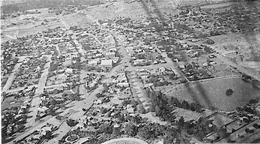
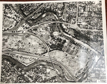
![Photograph - Aerial view of Sunshine, [1970s]](/media/collectors/5164c1772162ef0c64d700f2/items/69dc57946a5a9c1cb356d9b3/item-media/69dc597c6a5a9c1cb356eecf/item-fit-380x285.jpg?cb=6) Sunshine and District Historical Society Incorporated
Sunshine and District Historical Society IncorporatedPhotograph - Aerial view of Sunshine, [1970s]
... Aerial view of Sunshine...Aerial view of Sunshine...Aerial view of Sunshine business and residential district including railway line...Sunshine Overpass Bridge Hampshire Road Aerial view of Sunshine business and residential district including railway line Aerial view of Sunshine Photograph Aerial view of Sunshine ...Aerial view of Sunshine business and residential district including railway linesunshine, overpass, bridge, hampshire road -
 University of Melbourne, Burnley Campus Archives
Photograph - Black and white print, Aerial View of Burnley Campus, 1972
... Aerial View of Burnley Campus......aerial view...Aerial view of Burnley Campus....Aerial view of Burnley Campus. Aerial View of Burnley Campus Photograph Black and white print ...Black and white photograph. Aerial View of Burnley Campus. Enlargement of B92.553C. Aerial view of Burnley Campus.Inscribed on reverse, "30.1.72 2602/62."burnley campus, aerial view, freeway -
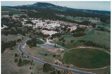 Buninyong & District Historical Society
Photograph - Colour Photograph of Mt Helen Campus, Aerial view of University of Ballarat, Mt. Helen Campus c1991
... Aerial view of University of Ballarat, Mt. Helen Campus c1991...Aerial view Mount Helen Campus c1991...Mt. Helen Campus. Aerial view to Mt. Buninyong c. 1991...Helen Campus Tertiary Education Mount Buninyong Rural Development Mt. Helen Campus. Aerial view to Mt. Buninyong c. 1991 Aerial view Mount Helen Campus c1991 Aerial view of University of Ballarat, Mt. ...Mount Helen Campus in its later building stages before becoming the University of Ballarat in 1994The University of Ballarat was formed from a number of varying types of tertiary schools, the earliest being the School of Mines in 1870 and finally became a University in 1994 Aerial view Mount Helen Campus c1991Mt. Helen Campus. Aerial view to Mt. Buninyong c. 1991university of ballarat, mt. helen campus, tertiary education, mount buninyong, rural development -
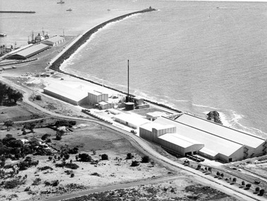
 Glenelg Shire Council Cultural Collection
Photograph - Photograph - aerial view of Portland harbour, 1960
... Photograph - aerial view of Portland harbour...Black and white aerial view of harbour....Front: Harbour: Aerial view south. July '60 - typed, bottom....Photograph Photograph - aerial view of Portland harbour ...Port of Portland AuthorityFront: Harbour: Aerial view south. July '60 - typed, bottom.port of portland archives, aerial photography, portland harbour -
 Camberwell Historical Society
Photograph, Camberwell Victoria, aerial view of the District, c. 1940
... Camberwell Victoria, aerial view of the District...Print of photograph with inscription 'Camberwell Victoria, aerial view of the District, c. 1940' ...Camberwell Victoria, aerial view of the District, c. 1940...Camberwell Historical Society 25 Inglesby Road Camberwell melbourne Camberwell Camberwell Victoria, aerial view of the District, c. 1940 Print of photograph with inscription 'Camberwell Victoria, aerial view of the District, c. 1940' Camberwell Victoria, aerial view of the District Photograph Photograph ...Print of photograph with inscription 'Camberwell Victoria, aerial view of the District, c. 1940' Camberwell Victoria, aerial view of the District, c. 1940camberwell -
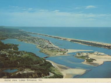
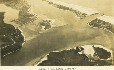 Lakes Entrance Historical Society
Postcard - Aerial view Lakes Entrance c1922, H D Bulmer, Roadnight Collection Postcards, 1922 c
... Aerial view Lakes Entrance c1922...Black and white postcard aerial view of the western area of the town, Bullock Island and Snake Island and waterways Lakes Entrance Victoria...Aerial View Lakes Entrance...Image clearly shows new alignment of Princes Highway around Jemmys Point and part of the original high road to the first bend above North Arm Bridge Waterways Islands Township Aerial View Lakes Entrance Black and white postcard aerial view of the western area of the town, Bullock Island and Snake Island and waterways Lakes Entrance Victoria Roadnight Collection Postcards Postcard Aerial view Lakes Entrance c1922 H D Bulmer ...Image clearly shows new alignment of Princes Highway around Jemmys Point and part of the original high road to the first bend above North Arm BridgeBlack and white postcard aerial view of the western area of the town, Bullock Island and Snake Island and waterways Lakes Entrance VictoriaAerial View Lakes Entrancewaterways, islands, township -
Glenelg Shire Council Cultural Collection
Photograph - Photograph - aerial view of Portland, 1960
... Photograph - aerial view of Portland...Black & white aerial view of Portland Harbour, looking south....Back: Aerial View South - July '60 -Top left, pencil...Photograph Photograph - aerial view of Portland ...Port of Portland Authority ArchivesBack: Aerial View South - July '60 -Top left, pencilport of portland archives, aerial photography, portland harbour -
 Lakes Entrance Historical Society
Postcard - Aerial view Lakes Entrance c1970, Murray View Gympie Qld, 1970 c
... Aerial view Lakes Entrance c1970...Black and white postcards showing aerial views of township, North Arm and Cunninghame Arm, Bullock Island and part of Kalimna Heights and Jemmys Point Lakes Entrance Victoria...Aerial view of Lakes Entrance Vic...Also a second postcard lookin west showing township, North Arm and Kalimna Heights 05213.1 10 x 15 cm Township Waterways Islands Aerial view of Lakes Entrance Vic Black and white postcards showing aerial views of township, North Arm and Cunninghame Arm, Bullock Island and part of Kalimna Heights and Jemmys Point Lakes Entrance Victoria Postcard Aerial view Lakes Entrance c1970 Murray View Gympie Qld ...Also a second postcard lookin west showing township, North Arm and Kalimna Heights 05213.1 10 x 15 cmBlack and white postcards showing aerial views of township, North Arm and Cunninghame Arm, Bullock Island and part of Kalimna Heights and Jemmys Point Lakes Entrance VictoriaAerial view of Lakes Entrance Victownship, waterways, islands -
 University of Melbourne, Burnley Campus Archives
Photograph - Black and white prints, Aerial View of Burnley Campus, 1963-1970
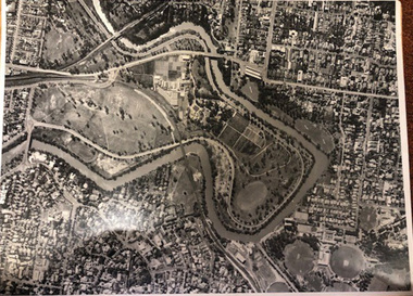
... Aerial View of Burnley Campus......aerial view...Black and white photographs. Aerial View of Burnley Campus. (B) Original of (A). ...Black and white photographs. Aerial View of Burnley Campus. (B) Original of (A). ...Freeway was not begun until 1968.Black and white photographs. Aerial View of Burnley Campus. (B) Original of (A). Enlargement (C) Laminated copy(A) Inscribed on reverse, "South Eastern Freeway 9.7.63 R22.024.439." (C) Paper attachment: The Burnley College Portion of Richmond Park in 1972. Swan Street Takes Its Familiar Route. The Boulevard Has Been Constructed. The Golf Course is in Place. The Series of Parallel Buildings Along the Railway Line at the Bottom of the Photo Are the Poultry Sheds Used For Egg-Laying Competitions. Burnley Sidings Were Still to be Built. In the Mid-1990's Much of the Western Portion of the College Grounds/Richmond Park Was Sold.burnley campus, aerial view, south eastern freeway, richmond park, swan street, yarra boulevard, richmond golf course, poultry sheds -
 University of Melbourne, Burnley Campus Archives
Photograph - Black and white print, Aerial View of Burnley Campus c. 1960, c. 1960
... Aerial View of Burnley Campus c. 1960......aerial view...Colour photograph of black and white photograph. Aerial View of Burnley Campus.Enlargement, showing layout of Burnley Campus. ...Aerial View of Burnley Campus.Enlargement, showing layout of Burnley Campus. ...Colour photograph of black and white photograph. Aerial View of Burnley Campus.Enlargement, showing layout of Burnley Campus. Same as B91.296burnley campus, aerial view, yarra river, freeway -
 University of Melbourne, Burnley Campus Archives
Photograph - Black and white print, Aerial View of Burnley Campus c.1965, c. 1965
... Aerial View of Burnley Campus c.1965...aerial view...Enlarged photograph of aerial view of Burnley College encompassed by the Yarra River and showing the surrounding suburban areas. ...Mounted on cardboard. Aerial View of Burnley Campus c.1965 Photograph Black and white print ...Black and white photograph. Enlarged photograph of aerial view of Burnley College encompassed by the Yarra River and showing the surrounding suburban areas. Mounted on cardboard.aerial view, burnley college, yarra river -
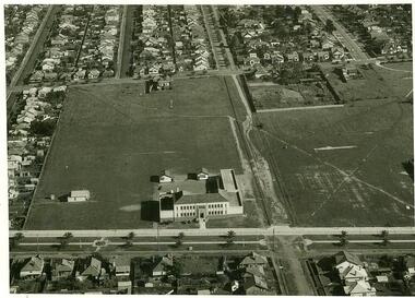
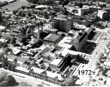 Ballarat Base Hospital Trained Nurses League
Aerial View of Ballarat Base Hospital, 1972
... Aerial View of Ballarat Base Hospital, 1972......aerial view...Aerial View of Ballarat Base Hospital, 1972...Ballarat Base Hospital Trained Nurses League Drummond Street Nth Ballarat goldfields Aerial View of Ballarat Base Hospital, 1972 Shows all hospital buildings including the Nurses Home nurses home 1972 aerial view Ballarat hospital Photo - black & white Aerial View of Ballarat Base Hospital, 1972 ...Aerial View of Ballarat Base Hospital, 1972Shows all hospital buildings including the Nurses HomePhoto - black & whitenurses, home, 1972, aerial view, ballarat, hospital -
 St Kilda Historical Society
Ephemera - Postcard, City of Port Phillip, St Vincent Gardens and aerial view of Sth Melbourne circa 1900, 1900
... St Vincent Gardens and aerial view of Sth Melbourne circa 1900...Postcard black and white aerial view of South Melbourne (2 copies). ...St Vincent Gardens and aerial view of South Melbourne circa 1900. Historic gardens in the City of Port Phillip Postcard series celebrating the launch of the Royal Botanic Garden's Melbourne, 'Flora for Victoria' 1996....Postcard black and white aerial view of South Melbourne (2 copies). St Vincent Gardens and aerial view of Sth Melbourne circa 1900 Ephemera Postcard City of Port Phillip ...Foreground showing St Vincent Gardens. One of a series of postcards celebrating the launch of 'Flora for Victoria 1996', a project to celebrate the Royal Botanic Gardens of Melbourne`s 150th anniversary and the centenary of the death of its first director Baron Ferdinand von Mueller (1825 -1896)Postcard black and white aerial view of South Melbourne (2 copies). St Vincent Gardens and aerial view of South Melbourne circa 1900. Historic gardens in the City of Port Phillip Postcard series celebrating the launch of the Royal Botanic Garden's Melbourne, 'Flora for Victoria' 1996.south melbourne, st vincent gardens -
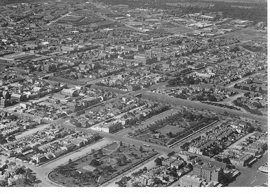
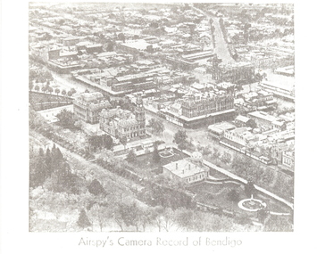 Bendigo Historical Society Inc.
Photograph - AERIAL VIEW: BENDIGO, Approx. 1935
... AERIAL VIEW: BENDIGO......Aerial view of bendigo...black and white photo ( from newspaper /): aerial view of Bendigo City Centre, Post Office and Shamrock Hotel. ...History House 11 Mackenzie Street Bendigo goldfields BHS Collection PLACE Aerial view of bendigo Airspy ? black and white photo ( from newspaper /): aerial view of Bendigo City Centre, Post Office and Shamrock Hotel. ...BHS Collectionblack and white photo ( from newspaper /): aerial view of Bendigo City Centre, Post Office and Shamrock Hotel. Rosalind Park in foreground, looking north east.Airspy ?place, aerial view of bendigo -
 City of Ballarat Libraries
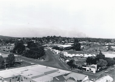
Photograph, Aerial View of the Ballarat CBD in 1957 / 1958
... Aerial View of the Ballarat CBD in 1957 / 1958....Aerial view...This aerial view of the Ballarat CBC was taken sometime in 1957 or 1958. ...Sturt Street can be seen running from the right centre to top left. Aerial view Sturt Street Ballarat Central Business District CBD Aerial View of the Ballarat CBD in 1957 / 1958. ...This aerial view of the Ballarat CBC was taken sometime in 1957 or 1958. Sturt Street can be seen running from the right centre to top left.aerial view, sturt street, ballarat, central business district, cbd -
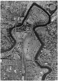
 Eltham District Historical Society Inc
Photograph, Aerial view of Yarra River near Kangaroo Ground - Bend of Islands area
... Aerial view of Yarra River near Kangaroo Ground - Bend of Islands area...Aerial view of Yarra river at Bend of Islands; Henley Road on left in foreground...Sepia aerial view of Yarra river at Bend of Islands; Henley Road on left in foreground...Aerial view of Yarra river at Bend of Islands; Henley Road on left in foreground bend of isles kangaroo ground yarra river henley road Sepia aerial view of Yarra river at Bend of Islands; Henley Road on left in foreground Aerial view of Yarra River near Kangaroo Ground - Bend of Islands area Photograph ...Aerial view of Yarra river at Bend of Islands; Henley Road on left in foregroundSepia aerial view of Yarra river at Bend of Islands; Henley Road on left in foregroundbend of isles, kangaroo ground, yarra river, henley road -
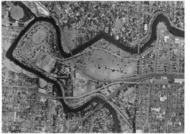
 University of Melbourne, Burnley Campus Archives
Photograph - Black and white print, Aerial View of Burnley Campus C.1970, c. 1970
... Aerial View of Burnley Campus C.1970......aerial view...Colour photograph of black and white photograph. Aerial View of Burnley Campus. Enlargement. Shows position of Campus in bend of Yarra River after alterations to the position of the river due to building of Freeway, new ovals and Richmond Public Golf Course....Aerial View of Burnley Campus C.1970 Photograph Black and white print ...Colour photograph of black and white photograph. Aerial View of Burnley Campus. Enlargement. Shows position of Campus in bend of Yarra River after alterations to the position of the river due to building of Freeway, new ovals and Richmond Public Golf Course.burnley campus, aerial view, yarra river, richmond public golf course -
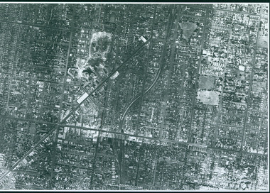
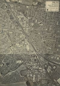 Sunshine and District Historical Society Incorporated
Photograph - Sunshine aerial view
... Sunshine aerial view...Sunshine aerial view...Aerial view of Sunshine Ballarat Road in the north. ...Sunshine Town Planning Ballarat Road Aerial view of Sunshine Ballarat Road in the north. ...Aerial view of Sunshine Ballarat Road in the north. Quarry Hole next to Market Street in the south To the east is Duke Street and Sydney Street On the west is Glengala Kororoit Creek west and south Sunshine Station and overpass in center Note McKay factory buildings still standing in center bottom of photo Spaldings Nettlefolds and Sunshine Cabinet buildings on top leftsunshine, town planning, ballarat road -
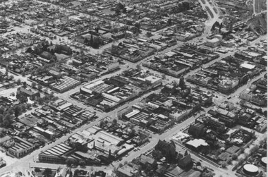
 Bendigo Historical Society Inc.
Photograph - AERIAL VIEW BENDIGO, 1995
... AERIAL VIEW BENDIGO......Aerial view of bendigo...Black and white photo: aerial view Mollison St., Jewel Shopping complex ( Noelene Wild 7/2000 ) from St. ...History House 11 Mackenzie Street Bendigo goldfields PLACE Aerial view of bendigo Peter Hyett Black and white photo: aerial view Mollison St., Jewel Shopping complex ( Noelene Wild 7/2000 ) from St. ...Black and white photo: aerial view Mollison St., Jewel Shopping complex ( Noelene Wild 7/2000 ) from St. Paul's tower ? Mollison St. left to right foreground. 'B22A' black lead on rear.Peter Hyettplace, aerial view of bendigo -
 University of Melbourne, Burnley Campus Archives
Photograph - Black and white print, Aerial View of Burnley Campus c. 1930, c. 1934
... Aerial View of Burnley Campus c. 1930......aerial view...Black and white photographs. Aerial Views of Burnley Campus. Enlargements. (A) Heyington Bridge to South, Yarra River on North side. ...Aerial Views of Burnley Campus. Enlargements. (A) Heyington Bridge to South, Yarra River on North side. ...Black and white photographs. Aerial Views of Burnley Campus. Enlargements. (A) Heyington Bridge to South, Yarra River on North side. (B) Heyington Bridge at top of photograph i.e. reverse view of (A). (C) Original of (B) mounted on board. Probably taken at the time of the floods of 30 November 1934. heyington bridge, yarra river, aerial view, burnley campus, 1934 flood -
 Bendigo Historical Society Inc.
Photograph - BENDIGO RAILWAY STATION: AERIAL VIEW, 1995
... BENDIGO RAILWAY STATION: AERIAL VIEW......Aerial view of bendigo...Black and white photo: aerial view looking trowards Bendigo Railway Station. ...History House 11 Mackenzie Street Bendigo goldfields PLACE Aerial view of bendigo bendigo railway station Peter Hyett 1995 Black and white photo: aerial view looking trowards Bendigo Railway Station. ...Black and white photo: aerial view looking trowards Bendigo Railway Station. Mitchell st. runs across lower part of photo. Photo taken prior to building of 'Market place' shopping centre. A 16A black lead on rear.Peter Hyett 1995place, aerial view of bendigo, bendigo railway station -
 Bendigo Historical Society Inc.
Photograph - AERIAL VIEW: BENDIGO, 1995
... AERIAL VIEW: BENDIGO......Aerial view of bendigo...Black and white photo: aerial view from St. Paul's church tower showing Bush's store in foreground. ...History House 11 Mackenzie Street Bendigo goldfields PLACE Aerial view of bendigo Peter Hyett Black and white photo: aerial view from St. ...Black and white photo: aerial view from St. Paul's church tower showing Bush's store in foreground. St. Andrew's church middle distance, Myers St. at left front to middle distance. Williamson St. left to right foreground.Peter Hyettplace, aerial view of bendigo -
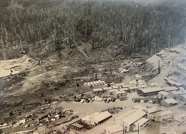
 Glenelg Shire Council Cultural Collection
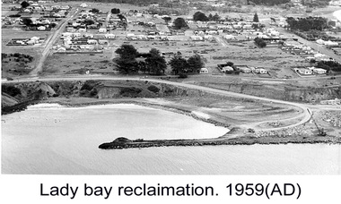
Photograph - Photograph - Lady Bay Reclamation: Aerial view looking West showing dumping of quarry overburden, 1959
... Photograph - Lady Bay Reclamation: Aerial view looking West showing dumping of quarry overburden...Lady Bay Reclamation: Aerial view looking West showing dumping of quarry overburden...Front: (no inscriptions) Back: 1959/ Lady Bay Reclamation/ Aerial view looking West showing dumping of/ Quarry overburden (black pen, upper left)...Lady Bay Reclamation: Aerial view looking West showing dumping of quarry overburden Photograph Photograph - Lady Bay Reclamation: Aerial view looking West showing dumping of quarry overburden ...Port of Portland Authority archivesFront: (no inscriptions) Back: 1959/ Lady Bay Reclamation/ Aerial view looking West showing dumping of/ Quarry overburden (black pen, upper left)port of portland archives, lady bay, reclamation, 1960s -
Stawell Historical Society Inc
Map, Crocodile Gold Corp, Photographic Aerial View of Big Hill showing underground workings and surface workings and proposed Big Hill Open Pit proposal, December 2014
... Photographic Aerial View of Big Hill showing underground workings and surface workings and proposed Big Hill Open Pit proposal....Aerial Views Stawell...Photographic Aerial View of Big Hill showing underground workings and surface workings and proposed Big Hill Open Pit proposal. ...Crocodile Gold Corp SGM photo Map showing Magdala Decline& Wonga Decline December 2014 Produced for Public Consultation over Big Hill Open Pit Proposal. Aerial Views Stawellmining, gold, map -
Glenelg Shire Council Cultural Collection
Postcard - Postcard - Portland Harbour, c. 1970
... ... aerial view of Portland Harbour...Coloured photo postcard, serrated edge. Aerial view of Portland and harbour, 1970s...'Portland Vic, Aerial view of Portland Harbour'...'Portland Vic, Aerial view of Portland Harbour' Coloured photo postcard, serrated edge. ...Coloured photo postcard, serrated edge. Aerial view of Portland and harbour, 1970sBack: Maker details. 'Portland Vic, Aerial view of Portland Harbour'postcard, aerial view of portland harbour -
 Sunshine and District Historical Society Incorporated
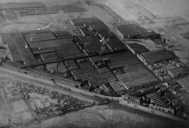
Photograph - Aerial view of HV McKay Massey Harris Factory, 1942
... Aerial view of HV McKay Massey Harris Factory...Aerial view of HV McKay Massey Harris Factory...Aerial view of HV McKay Massey Harris Factory building administration office and Sunshine including Sunshine Gardens and gardeners residence This photograph shows many other points of historical nature Top Left 1 Storage shed stacks of timber air drying 2 Old clock tower and new factory office block 3 Main or head office block opposite clock tower Then along Devonshire Road Adjacent to Head Office new drawing office on 1st floor over new workshop for experimental department These two later amalgamated and formed what became known as The Engineering Department Right Centre 4 on both sides of Devonshire Road 5 State Savings Bank before rebuilding 6 Blair Athol guesthouse with National Bank on ground floor opposite State Savings Bank 7 Along Hampshire away from Blair Athol some houses then McKays laboratory Duplicates department Service Street Morgue Steel Storage and Pickling Annex and Roberts Quarry and some houses in background top right Top Left to Right 8 In front of timber stacks Stony Creek winds through factory site to dam fire fighting before running under Hampshire Road in front of Annexe and Quarry across Service Street Creek was diverted through a channel and tunnel not shown Also Railway lines to Bendigo and Mildura show McKays railway engine hauling trucks from factory...McKay Massey Harris Sunshine Devonshire Road Aerial view of HV McKay Massey Harris Factory building administration office and Sunshine including Sunshine Gardens and gardeners residence This photograph shows many other points of historical nature Top Left 1 Storage shed stacks of timber air drying 2 Old clock tower and new factory office block 3 Main or head office block opposite clock tower Then along Devonshire Road Adjacent to Head Office new drawing office on 1st floor over new workshop for experimental department These two later amalgamated and formed what became known as The Engineering Department Right Centre 4 on both sides of Devonshire Road 5 State Savings Bank before rebuilding 6 Blair Athol guesthouse with National Bank on ground floor opposite State Savings Bank 7 Along Hampshire away from Blair Athol some houses then McKays laboratory Duplicates department Service Street Morgue Steel Storage and Pickling Annex and Roberts Quarry and some houses in background top right Top Left to Right 8 In front of timber stacks Stony Creek winds through factory site to dam fire fighting before running under Hampshire Road in front of Annexe and Quarry across Service Street Creek was diverted through a channel and tunnel not shown Also Railway lines to Bendigo and Mildura show McKays railway engine hauling trucks from factory Aerial view of HV McKay Massey Harris Factory Photograph Aerial view of HV McKay Massey Harris Factory ...Aerial view of HV McKay Massey Harris Factory building administration office and Sunshine including Sunshine Gardens and gardeners residence This photograph shows many other points of historical nature Top Left 1 Storage shed stacks of timber air drying 2 Old clock tower and new factory office block 3 Main or head office block opposite clock tower Then along Devonshire Road Adjacent to Head Office new drawing office on 1st floor over new workshop for experimental department These two later amalgamated and formed what became known as The Engineering Department Right Centre 4 on both sides of Devonshire Road 5 State Savings Bank before rebuilding 6 Blair Athol guesthouse with National Bank on ground floor opposite State Savings Bank 7 Along Hampshire away from Blair Athol some houses then McKays laboratory Duplicates department Service Street Morgue Steel Storage and Pickling Annex and Roberts Quarry and some houses in background top right Top Left to Right 8 In front of timber stacks Stony Creek winds through factory site to dam fire fighting before running under Hampshire Road in front of Annexe and Quarry across Service Street Creek was diverted through a channel and tunnel not shown Also Railway lines to Bendigo and Mildura show McKays railway engine hauling trucks from factoryh.v. mckay massey harris, sunshine, devonshire road