Showing 67 items matching "agricultural surveying"
-
 Tatura Irrigation & Wartime Camps Museum
Book, Agricultural Surveying, 1901
... Agricultural Surveying...agricultural surveying...Tatura Irrigation & Wartime Camps Museum 49 Hogan Street Tatura the-murray Used by surveyors agricultural surveying scott proff j tatura surveying irrigation terrestrial Light brown cloth covered cardboard cover. "245" and "1/6" on the spine Agricultural Surveying Book ...Used by surveyorsLight brown cloth covered cardboard cover. "245" and "1/6" on the spineagricultural surveying, scott, proff j, tatura, surveying, irrigation, terrestrial -
University of Melbourne, Burnley Campus Archives
Document, 1979 - 81 Triennial Survey, 1978
... survey...tafe...courses...department of agriculture...TAFEC Triennial Survey, Dept. of Agriculture Triennial Surveys for TAFE and CAE courses. 3...University of Melbourne, Burnley Campus Archives 500 Yarra Boulevard Richmond melbourne tafec triennal survey tafe courses department of agriculture TAFEC Triennial Survey, Dept. of Agriculture Triennial Surveys for TAFE and CAE courses. 3 1979 - 81 Triennial Survey Document ...TAFEC Triennial Survey, Dept. of Agriculture Triennial Surveys for TAFE and CAE courses. 3tafec, triennal survey, tafe, courses, department of agriculture -
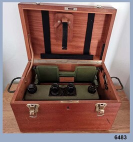
 Tatura Irrigation & Wartime Camps Museum
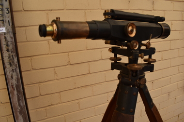
Dumpy Level, Dumpty Level, 1920
... Used by Mr. Craven to survey agricultural land in the Goulburn Valley for the purposes of setting out farm irrigation channels and check banks...Tatura Irrigation & Wartime Camps Museum 49 Hogan Street Tatura the-murray Used by Mr. Craven to survey agricultural land in the Goulburn Valley for the purposes of setting out farm irrigation channels and check banks surveying irrigation terrestrial Patent Stanlley, Great Turnside, Holborn, London 11182 Stanlley Dumpy Level on tripod, complete with carrying case and sixteen foot telescopic staff Dumpty Level Dumpy Level ...Used by Mr. Craven to survey agricultural land in the Goulburn Valley for the purposes of setting out farm irrigation channels and check banksStanlley Dumpy Level on tripod, complete with carrying case and sixteen foot telescopic staffPatent Stanlley, Great Turnside, Holborn, London 11182surveying, irrigation, terrestrial -
Tatura Irrigation & Wartime Camps Museum
Carry Case, 1920
... Used in conjunction with dumpy level, by Mr. Craven to survey agricultural land in the Goulburn Valley for the pruposes of setting out farm irrigation channels and check banks...Tatura Irrigation & Wartime Camps Museum 49 Hogan Street Tatura the-murray Used in conjunction with dumpy level, by Mr. Craven to survey agricultural land in the Goulburn Valley for the pruposes of setting out farm irrigation channels and check banks carry case dumpy level craven b tatura surveying irrigation terrestrial Rectangular wooden box, divided into 5 sections with lid attached and closed with 2 metal fasteners on to 2 screws on the lid and key hole lock (no key). 2 leather straps with 2 buckles are attached by 2 metal bars, small screw driver and metal cap from telescope on dumpy level. ...Used in conjunction with dumpy level, by Mr. Craven to survey agricultural land in the Goulburn Valley for the pruposes of setting out farm irrigation channels and check banksRectangular wooden box, divided into 5 sections with lid attached and closed with 2 metal fasteners on to 2 screws on the lid and key hole lock (no key). 2 leather straps with 2 buckles are attached by 2 metal bars, small screw driver and metal cap from telescope on dumpy level.carry case, dumpy level, craven b, tatura, surveying, irrigation, terrestrial -
University of Melbourne, Burnley Campus Archives
Administration, Students 8/4, 1979-1980
... Student numbers, Agricultural Education 2. Unused Survey 1978 produced by Dr. ...students administration student numbers agricultural education survey peter may commonwealth special research grant Manila folder, tied with a shoelace. 30.01.1979-1980 1. ...students, administration, student numbers, agricultural education, survey, peter may, commonwealth special research grant -
 Federation University Historical Collection
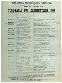
poster, J. Kemp, Education Department Victoria Technical School Timetable for Examinations, 1910, 1910
... Subjects included Chemistry, Geology, Asssaying, Hydraulics, Agriculture, Engineering , Mine Surveying, Algebra, Mineralogy, petrology, Botany, Trigonometry, Euclid, Land Surveying, Steam and gas Engines, Applied Mechanics, Drawing, painting, engineering drawing, building construction, architecture, drapery, modelled design, casting clay models, composition of form and colour, Lettering, Wood Carving, historic ornament, Wood Carving. .1) Trade Subjects .2) Other subjects, including art...Subjects included Chemistry, Geology, Asssaying, Hydraulics, Agriculture, Engineering , Mine Surveying, Algebra, Mineralogy, petrology, Botany, Trigonometry, Euclid, Land Surveying, Steam and gas Engines, Applied Mechanics, Drawing, painting, engineering drawing, building construction, architecture, drapery, modelled design, casting clay models, composition of form and colour, Lettering, Wood Carving, historic ornament, Wood Carving. .1) Trade Subjects .2) Other subjects, including art Education Department Victoria Technical School Timetable for Examinations, 1910 poster J. ...Large printed timetable for Technical School examinations in 1901. Subjects included Chemistry, Geology, Asssaying, Hydraulics, Agriculture, Engineering , Mine Surveying, Algebra, Mineralogy, petrology, Botany, Trigonometry, Euclid, Land Surveying, Steam and gas Engines, Applied Mechanics, Drawing, painting, engineering drawing, building construction, architecture, drapery, modelled design, casting clay models, composition of form and colour, Lettering, Wood Carving, historic ornament, Wood Carving. .1) Trade Subjects .2) Other subjects, including artexaminations, technical schools, trades, art, technical art school, timetable, clay modelling, ceramics -
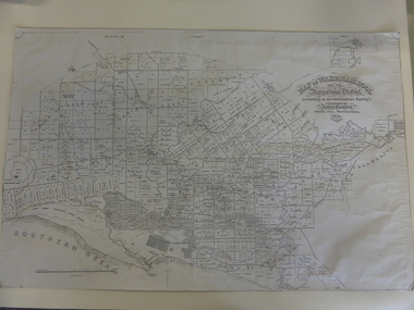
 Warrnambool and District Historical Society Inc.
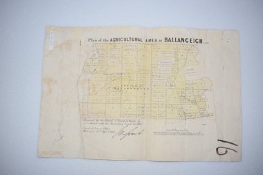
Original Document, Map: Agricultural area of Ballangeich 1865, 1865
... At the top: Plan of the Agricultural area of Ballangeich 1865 At the bottom left: Prepared by the Board of Lands & Works in accordance with the Amending Land Act 1865 Lands & Survey Office Melbourne 13th April 1865. ...This map is typical of many which were produced in the 1860's in Victoria during a significant period of Victoria's and Warrnambool district history. history of warrnambool ballangeich Land surveys Victoria 1865 Lands Act 1865 Victoria Ballangeich map 1865 At the top: Plan of the Agricultural area of Ballangeich 1865 At the bottom left: Prepared by the Board of Lands & Works in accordance with the Amending Land Act 1865 Lands & Survey Office Melbourne 13th April 1865. ...George Eddington arrived in Australia in 1839 and named and established property in 1841 calling the property Ballangeich after a Pass near his home town of Stirling in Scotland. It is situated 151 miles west of Melbourne and to the south of Mortlake and was originally part of the Mortlake shire, which was proclaimed 26th Jan 1864. Nearest streams are the Hopkins Riverand Lyall and Drysdale creek running through good agricultural land. This map relates to the breaking up of large runs which the Victorian government enabled through selection acts of the 1860's. The previously larger runs which were mainly cattle and sheep based were now more open to closer settlement and a greater variety in farming.The lots range in size from approximately 50 acres to around 600 acres.Some areas are set aside for reserves. By 1886 the population of Ballangeich had grown to around 600 with an hotel, three state schools and a church.Tri weekly coaches ran to Colac, Warrnambool and Camperdown providing access to supplies mail and communication. This map is typical of many which were produced in the 1860's in Victoria during a significant period of Victoria's and Warrnambool district history.Rectangular light card paper with black text showing allotments of land The area is coloured in green with scale at bottom right cornerAt the top: Plan of the Agricultural area of Ballangeich 1865 At the bottom left: Prepared by the Board of Lands & Works in accordance with the Amending Land Act 1865 Lands & Survey Office Melbourne 13th April 1865. With signaturehistory of warrnambool, ballangeich, land surveys victoria 1865, lands act 1865 victoria, ballangeich map 1865 -
 Warrnambool and District Historical Society Inc.
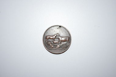
Medal, Stokes and Martin, Rutledge Brothers, 1877
... Agricultural Show is still held annually. The medal, first prize for the best horse hay rake, was awarded in 1877 to the brothers, Thomas and William Rutledge, sons of Eliza and William Rutledge. The latter was a pioneer settler who came to the Warrnambool/Port Fairy district as the purchaser of the Special Survey, Farnham Park in 1841. ...Survey, living at Farnham Park, He later lived at Airlie in Henna Street, Warrnambool and Sherwood on the Hopkins River and had land in the Otway Ranges. He later went to New Zealand. This medal is of considerable significance because of its age and its association with Thomas and William Rutledge and with the Villiers and Heytesbury Agricultural Association. ...This medal was made by Stokes and Martin. Thomas Stokes established a medal-making business in Melbourne in 1856 and from 1867 to 1893 he had a partner, George Frederick Martin. In 1962 the Stokes business became a public company and operates today in Melbourne. The medal was awarded at the Annual Show of the Villiers and Heytesbury Agricultural Association in 1877. One of the earliest agricultural associations in Victoria, the V.& H.A.A., the forerunner of the Warrnambool Agricultural Society, was established in 1854 and the first Warrnambool Show was held in 1855 at the first Royal Archer Hotel in Koroit Street. The Warrnambool Agricultural Show is still held annually. The medal, first prize for the best horse hay rake, was awarded in 1877 to the brothers, Thomas and William Rutledge, sons of Eliza and William Rutledge. The latter was a pioneer settler who came to the Warrnambool/Port Fairy district as the purchaser of the Special Survey, Farnham Park in 1841. His land stretched from Tower Hill to Dennington. William Rutledge Senior was a pioneer breeder of a Lincoln sheep stud, the owner of a mercantile business in Port Fairy, a member of the Legislative Council of Victoria and the pioneer developer of farming land around Tower Hill. His son Thomas (1846-1918) was a Warrnambool Shire Councillor who farmed in the Farnham Survey, living at Werronggurt . He went to the Geelong area at the end of the 19th century. His brother William (1849-1935) also farmed in the Farnham Survey, living at Farnham Park, He later lived at Airlie in Henna Street, Warrnambool and Sherwood on the Hopkins River and had land in the Otway Ranges. He later went to New Zealand.This medal is of considerable significance because of its age and its association with Thomas and William Rutledge and with the Villiers and Heytesbury Agricultural Association.This is a bronze medal with an image of agricultural implements, agricultural produce and farm animals on one side and etched printing on the other side. There is also printing around the edge of the medal. The medal has a small hole at the top for attaching the medal to a cord. Villiers & Heytesbury Agricultural Association 1st Prize awarded to Rutledge Bro. for Horse Hay Rake Annual Show Warrnambool 10 Oct. 1877 Stokes & Martin Melbourne thomas and william rutledge, farnham special survey, villiers and heytesbury agricultural association, warrnambool agricultural society, history of warrnambool -
 Warrnambool and District Historical Society Inc.
Map, Warrnambool 1859, Late 20th century (copy)
... ‘Map of Warrnambool and its Agricultural District according to the Government Survey’s published by Astley Bromfield, Medical Hall, Warrnambool 1856, James Ferguson, Lithr., Melbne.’...Bromfield’s 1856 map Warrnambool and District ‘Map of Warrnambool and its Agricultural District according to the Government Survey’s published by Astley Bromfield, Medical Hall, Warrnambool 1856, James Ferguson, Lithr., Melbne.’ ...This is a copy of Bromfield’s 1856 map of Warrnambool and district. James Astley Bromfield was a pioneer settler in Warrnambool. He established a chemist’s shop in 1854, initially situated in Timor Street. He moved his shop to Liebig Street with a new building erected in 1875. Bromfield was a prominent resident of Warrnambool (Shire Councillor, Fire Brigade member, Cricket Club member, associated with horse racing etc). He was interested in preserving the history of Warrnambool and this map he produced in 1856 was an example of this interest.This is a copy only but this 1856 map is of prime importance as it contains the names of the original landowners of land in north Warrnambool and the surrounding district. It is a frequently-used resource by historians.This is a copy of a map of Warrnambool and its agricultural district published by James Astley Bromfield in 1856. The map is mounted on cardboard and has black printing on a white background. ‘Map of Warrnambool and its Agricultural District according to the Government Survey’s published by Astley Bromfield, Medical Hall, Warrnambool 1856, James Ferguson, Lithr., Melbne.’bromfield’s 1856, map, warrnambool and district -
 Bendigo Military Museum
Instrument - Old Delft Scanning Stereoscope ODSS III, C. 1956
... Agricultural purposes. See also Bendigo RSL Collections Victoria item Number 6205.6P that shows the Old Deft Stereoscope in use at the Army Survey Regiment, Bendigo....Agricultural purposes. See also Bendigo RSL Collections Victoria item Number 6205.6P that shows the Old Deft Stereoscope in use at the Army Survey Regiment, Bendigo. ...This is a superbly crafted cartographic mapping instrument. It is housed in its own high-quality purpose-built oak box. Made in the Netherlands from 1950 onwards. This instrument is from c 1956. it is a very high-quality military grade stereoscope that was generally used by photographic interpreters such as intelligence analysts but was equally useful for mapping activities. The stereoscope was used to examine 3D aerial photographic images. This instrument has a particularly useful capability to scan over the 3D stereo model using X and Y movement knobs, rather than having to physically move the aerial photographs. In the public and private sector it was also useful for photogrammetric interpretation for Forestry and Agricultural purposes. See also Bendigo RSL Collections Victoria item Number 6205.6P that shows the Old Deft Stereoscope in use at the Army Survey Regiment, Bendigo.This is an "Old Delft" scanning stereoscope with its reflecting carriage and legs. The Stereoscope is housed in its own purpose built wooden oak box that has dovetail joints, 2 x securing clips, 2 x handles and a lock (without key). The instrument is assembled by inserting colour coded legs into their matching slots."OLD DELFT SCANNING STEREOSCOPE ODSS III" "Patents Applied for" "OLD DELFT C4790" "MADE IN THE NETHERLANDS"royal australian survey corps, rasvy, fortuna, army survey regiment, army svy regt, asr -
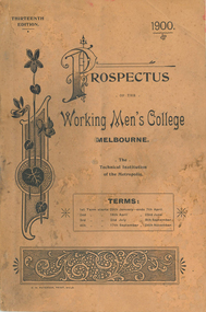 Federation University Historical Collection
Book - Book - Prospectus, The Working Men's College Melbourne, Prospectus,1900, 1900
... The majority of classes were at night and on Saturdays. working men's college melbourne rmit w.c. kernot w.h. embling ormond statue f. ormond electricity surveying architecture photography assaying dressmaking veterinary science plumbing letterpress printing w. ison h.d. evans library denton hat mills literary and commercial department typewriting department languages telegraphy department of music department of mathematics department of engineering 'department of architecture department of art and applied art department of mining and metallurgy department of chemistry department of household economy department of agriculture and rural industries woodworking carpentry and joinery turning and fitting coachbuilding and carriagedrafting Tan soft covered book of 112 pages. ...The Working Men’s College was founded in 1881 by a prominent grazier and philanthropist, The Hon. Francis Ormond, who donated £5000 towards the establishment of the college. The Council of the Melbourne Trades Hall then matched Ormond's initial donation by rallying its members. On 4 June 1887, the college opened in its purpose-built building on the corners of Bowen Street and La Trobe Street in Melbourne, with a gala ceremony. It became the third official provider of higher education in the new Colony of Victoria (the Melbourne Athenaeum was founded in 1839 and the University of Melbourne in 1853). The college was the predecessor to the current-day Royal Melbourne Institute of Technology (RMIT University). Adjoining the college in the 1890s were the Supreme Court of Victoria (later the Melbourne Magistrates' Court) and the Melbourne Gaol - both which are now part of RMIT today. A list of Scholarship Governors and Life Governors is included. The former have donated 250 Pounds Sterling and upwards, the later have donated 20 Pounds and over but less than 250 Pounds Sterling. The Patron of The Working Men's College was His Excellency The Right Honourable Lord Brassey. The President of the Council was Professor W C Kernot. The majority of classes were at night and on Saturdays. Tan soft covered book of 112 pages. The thirteenth edition of the Working Men's College (later Royal Melbourne Institute of Technology [RMIT]). It inlcudes the following photographic images: Main Building, Assaying, 1899 council (W.C. Kernot, W.H. Embling, Thomas smith, F.H. Bromley, John Reid, R.H. Solly, E. Findley, D. McIvor, James Robb, John Hancock, C.E. Oliver, A.J. Arnot, James Smith, Joseph Nixon, R.L.Jellery. C.S. Paterson), UNveiling the Ormond Statue, Victorian Lead and Shot Works, Francis Ormond, Telegraphy room, Lecture Theatre, photography, painting class, wool sorting, plumbing, Remington typewriter, W. Ison, H.D. Evans, library, Verdon prize, Denton Hat Mills. working men's college melbourne, rmit, w.c. kernot, w.h. embling, ormond statue, f. ormond, electricity, surveying, architecture, photography, assaying, dressmaking, veterinary science, plumbing, letterpress printing, w. ison, h.d. evans, library, denton hat mills, literary and commercial department, typewriting department, languages, telegraphy, department of music, department of mathematics, department of engineering, 'department of architecture, department of art and applied art, department of mining and metallurgy, department of chemistry, department of household economy, department of agriculture and rural industries, woodworking, carpentry and joinery, turning and fitting, coachbuilding and carriagedrafting -
Federation University Historical Collection
Book - Book- Syllabues, Education Department, Victoria, Technical School. Syllabuses for subject, 1914, 1914
... Barker Library (top floor) Mount Helen goldfields Used at the Ballarat School of Mines ballarat school of mines education department technical school chemistry food analysis assaying metallurgy mathematics geology mineralogy mining mechanics electricity sound and light surveying engineering hydraulics irrigation biology agriculture commerical telegraphy postal mechanics turning and fitting milling blacksmithing carpentry joining plumbing printing dressmaking photography millinery cookery petrology wool classing sorting junior technical school syllabus courses for diplomas Book with no front cover with courses for technical schools. ...Used at the Ballarat School of MinesBook with no front cover with courses for technical schools. Back cover is pale blue. ballarat school of mines, education department, technical school, chemistry, food analysis, assaying, metallurgy, mathematics, geology, mineralogy, mining, mechanics, electricity, sound and light, surveying, engineering, hydraulics, irrigation, biology, agriculture, commerical, telegraphy, postal mechanics, turning and fitting, milling, blacksmithing, carpentry, joining, plumbing, printing, dressmaking, photography, millinery, cookery, petrology, wool classing, sorting, junior technical school syllabus, courses for diplomas -
Federation University Historical Collection
Booklet, General Syllabus of Examinations Science and Trade Subjects Technical Schools, 1906, 1906
... A O Sachse was the Minister of Public Instruction and Frank Tate was the Director of Education. education department victoria syllabus examinations science trade technical schools a.o. sachse frank tate agriculture algebra applied mechanics arithmetic assaying blacksmithing botany carpentry joinery chemistry coach building cookery dressmaking land surveying metallurgy mineralogy mining plumbing printing wool sorting minister of public instruction director of education 1904 Green soft cover booklet holding the general syllabus of examinations in Science and trade Subjects in Technical Schools. ...Education Department of Victoria, "General Syllabus of Examinations in Science and Trade Subjects", published in 1906. A O Sachse was the Minister of Public Instruction and Frank Tate was the Director of Education.Green soft cover booklet holding the general syllabus of examinations in Science and trade Subjects in Technical Schools.education department victoria, syllabus, examinations, science, trade, technical schools, a.o. sachse, frank tate, agriculture, algebra, applied mechanics, arithmetic, assaying, blacksmithing, botany, carpentry, joinery, chemistry, coach building, cookery, dressmaking, land surveying, metallurgy, mineralogy, mining, plumbing, printing, wool sorting, minister of public instruction, director of education, 1904 -
 Federation University Historical Collection
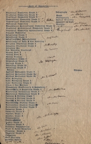
Document, List of Subjects
... Walker Theoretical Chemistry Theoretical Agricultural Chemistry Practical Agricultural Chemistry Technical Chemistry Metallurgy Alfred Mica Smith Metallurgical Calculations Metallurgy of Gold and ore Dressing Assaying practical Assaying Dry Mr. Murphy Ore Dressing Practical Mining Mining Geology Mineralogy Geology Petrology Botany Applied Mechanics Mr Hart Mine Surveying Land Surveying Steam and Gas Engines Mr Gilchrist Elementry Electricity & Magnetism Electrical Technology Mr Sutherland Turning and Fitting Mr Connon Engineering Drawing Mr Kerr Geometry Algebra Trigonometry Physics Conics Calculus Mr Whitington Building Construction Plane and Solid Geometry Plumbing Grade Mr Hall Mr Mullins Carpentry Wool Classing Materia Medica Mr Gutheil Technical Arithmatic Mr Hutchison Telegraphy Mr Williams Sloyd Mr Slater Photography Mr Campbell Manual Training Cyanide Mr Deane Mr Brittain Mr Martell English Astronomy List of subjects 8S3S in large writng on the back Foolscap sized list of Subjects from Ballarat School of Mines with handwritten names. ...School of Mines Ballarat is predecessor of Federation University Foolscap sized list of Subjects from Ballarat School of Mines with handwritten names.8S3S in large writng on the back school of mines ballarat, practical chemistry, mr. walker, theoretical chemistry, theoretical agricultural chemistry, practical agricultural chemistry, technical chemistry, metallurgy, alfred mica smith, metallurgical calculations, metallurgy of gold and ore dressing, assaying practical, assaying dry, mr. murphy, ore dressing practical, mining, mining geology, mineralogy, geology, petrology, botany, applied mechanics, mr hart, mine surveying, land surveying, steam and gas engines, mr gilchrist, elementry electricity & magnetism, electrical technology, mr sutherland, turning and fitting, mr connon, engineering drawing, mr kerr, geometry, algebra, trigonometry, physics, conics, calculus, mr whitington, building construction, plane and solid geometry, plumbing grade, mr hall, mr mullins, carpentry, wool classing, materia medica, mr gutheil, technical arithmatic, mr hutchison, telegraphy, mr williams, sloyd, mr slater, photography, mr campbell, manual training, cyanide, mr deane, mr brittain, mr martell, english, astronomy, list of subjects -
 Federation University Historical Collection
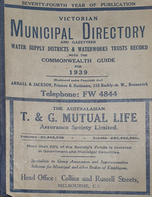
Book - Street Directory, Arnall & Jackson Pty Ltd, Victorian Municipal Directory and Gazatteer, 1939, 1939
... Agriculture...Charities...county court...crown lands and survey...Victorian municipalities municipal councils water supply advertisements Aboriginal Protection Board Agriculture Charities county court crown lands and survey Engine Drivers Board Licensing Court Sludge Abatement Board Cities towns boroughs Ballarat Buninyong Gordon grenville Talbot Traralgon Ballaarat Happy Valley Bungaree Daylesford Glenlyon Glenlyon Shire Hepburn SPrings Beige cover with blue spine. 1052 pages. ...Beige cover with blue spine. 1052 pages. It includes an index to townships, parishes and Railway stations. non-fictionvictorian municipalities, municipal, councils, water supply, advertisements, aboriginal protection board, agriculture, charities, county court, crown lands and survey, engine drivers board, licensing court, sludge abatement board, cities, towns, boroughs, ballarat, buninyong, gordon, grenville, talbot, traralgon, ballaarat, happy valley, bungaree, daylesford, glenlyon, glenlyon shire, hepburn springs -
Federation University Historical Collection
Book - Directory, Arnall & Jackson Pty Ltd, Victorian Municipal Directory and Gazatteer, 1935, 1935
... Agriculture...Charities...county court...crown lands and survey...Victorian municipalities municipal councils water supply advertisements Aboriginal Protection Board Agriculture Charities county court crown lands and survey Engine Drivers Board Licensing Court Sludge Abatement Board Cities towns boroughs Ballarat Buninyong Gordon grenville Talbot Traralgon Ballaarat Happy Valley Bungaree Daylesford Glenlyon Glenlyon Shire Hepburn SPrings Brown cover with maroon spine. 801 pages. ...Brown cover with maroon spine. 801 pages. It includes an index to townships, parishes and Railway stations. non-fictionvictorian municipalities, municipal, councils, water supply, advertisements, aboriginal protection board, agriculture, charities, county court, crown lands and survey, engine drivers board, licensing court, sludge abatement board, cities, towns, boroughs, ballarat, buninyong, gordon, grenville, talbot, traralgon, ballaarat, happy valley, bungaree, daylesford, glenlyon, glenlyon shire, hepburn springs -
Federation University Historical Collection
Book - Directory, Arnall & Jackson Pty Ltd, Victorian Municipal Directory and Gazatteer, 1924, 1924
... Agriculture...Charities...county court...crown lands and survey...Victorian municipalities municipal councils water supply advertisements Aboriginal Protection Board Agriculture Charities county court crown lands and survey Engine Drivers Board Licensing Court Sludge Abatement Board Cities towns boroughs Ballarat Buninyong Gordon grenville Talbot Traralgon Ballaarat Happy Valley Bungaree Daylesford Glenlyon Glenlyon Shire Hepburn SPrings Brown cover with blue spine. 708 pages. ...Brown cover with blue spine. 708 pages. It includes an index to townships, parishes and Railway stations. non-fictionvictorian municipalities, municipal, councils, water supply, advertisements, aboriginal protection board, agriculture, charities, county court, crown lands and survey, engine drivers board, licensing court, sludge abatement board, cities, towns, boroughs, ballarat, buninyong, gordon, grenville, talbot, traralgon, ballaarat, happy valley, bungaree, daylesford, glenlyon, glenlyon shire, hepburn springs -
 Federation University Historical Collection
Books, H.E. Daw Government Printer, Ballarat School of Mines and Industries Departmental Papers, 1914-1950, 1914-1950
... Examinations include: Agriculture, Algebra, Architecture, Arithmetic, Applied Mechanics, Assaying, Biology, Botany, Boilermaking, Building Design, Blacksmithing, Bricklaying, Carpentry and Joinery, Coachbuilding, Cabinet Making, Civil Engineering, Cabinet Making, Commercial, Chemistry, Engineering Drawing, Economics, English, Electrical technology, Electricity and Magnetism, Electric Wiring, Electric Welding, Electrical Fitting, Electrical Trades, Food Analysis, Geology, Geological Mapping, Graphics, Geometry, Heat Engines, Heat Treatment, Hydraulics, Hand Railing, Instrument Making, Millinery, Milling and Gearouting, Machine Shop Practice. Metal Founding, Mining, Metallurgy, Mineralogy, Mathematics, Motor Mechanics, Mine Surveying...Examinations include: Agriculture, Algebra, Architecture, Arithmetic, Applied Mechanics, Assaying, Biology, Botany, Boilermaking, Building Design, Blacksmithing, Bricklaying, Carpentry and Joinery, Coachbuilding, Cabinet Making, Civil Engineering, Cabinet Making, Commercial, Chemistry, Engineering Drawing, Economics, English, Electrical technology, Electricity and Magnetism, Electric Wiring, Electric Welding, Electrical Fitting, Electrical Trades, Food Analysis, Geology, Geological Mapping, Graphics, Geometry, Heat Engines, Heat Treatment, Hydraulics, Hand Railing, Instrument Making, Millinery, Milling and Gearouting, Machine Shop Practice. Metal Founding, Mining, Metallurgy, Mineralogy, Mathematics, Motor Mechanics, Mine Surveying ...Used at the Ballarat School of Mines and the Ballarat Technical Art SchoolThis collection of examinations is significant because of its completeness with the full range of examinations between 1914 and 1950.Large leather bound books, with leather spine, containing all examinations held at the Ballarat School of Mines (including the Ballarat Technical Art School and Ballarat Junior Technical School). The examination papers were supplied and printed by the Education Department, Victoria. Examinations include: Agriculture, Algebra, Architecture, Arithmetic, Applied Mechanics, Assaying, Biology, Botany, Boilermaking, Building Design, Blacksmithing, Bricklaying, Carpentry and Joinery, Coachbuilding, Cabinet Making, Civil Engineering, Cabinet Making, Commercial, Chemistry, Engineering Drawing, Economics, English, Electrical technology, Electricity and Magnetism, Electric Wiring, Electric Welding, Electrical Fitting, Electrical Trades, Food Analysis, Geology, Geological Mapping, Graphics, Geometry, Heat Engines, Heat Treatment, Hydraulics, Hand Railing, Instrument Making, Millinery, Milling and Gearouting, Machine Shop Practice. Metal Founding, Mining, Metallurgy, Mineralogy, Mathematics, Motor Mechanics, Mine Surveying, Mining Mechanics, Petrology, Physics, Painting and Decorating, Pattern Making, Plastering, Plumbing and Gasfitting, Printing, Refrigeration, Spelling, Science , Shorthand, Surveying. Signwriting. Sheet Metalwork, Toolmaking, Ladies Tailoring, Trigonometry, Typewriting, Welding, Commercial Geography. Millinery, Dressmaking, Needlework, Decorative Needlework, Architecture, Building Design and Construction, Art (Composition in Form and Colour), Art (Casting Clay MOdels) Art (Drapery), Art (Drawing the Human Figure From Casts), Art (Drawing the Antique from Memory), Art (Drawing from Memory); Art (Drawing Plant Forms from Nature, Art (Drawing Plant Forms From Memory), Art (Drawing from Models and Objects), (Drawing From a Flat Example). Art (Drawing in Light and Shade from a Cast of Ornament or Lower Nature), Art (Drawing Ornament from the Cast), Art (Drawing from Models or Objects), Art (Drawing fro Dressmakers' and Milliners' Fashions), Art (Drawing With the Brush), Art (Drawing from a Flat Example); Art (Modelled Design), Art (General Design), Art (Embossed Leatherwork), Art (Practical Plane Geometry), Art (Practical Solid Geometry), Art (Geometrical Drawing), Carpentry and Joinery, Art (Human Anatomy), Art (Historic Ornament), Art (House Decoration), Art (LEttering), Signwriting, Art (Light Metalwork), Art (Modelling), Art (Modelling the Human Figure from a Life), Art (Stencilling); Art (Wood Carving) Refrigeration, Teaching, Boilermaking, Blacksmithing, Carpentry and Joinery, Coachbuilding and Carriage Drafting, Electric Wiring, Electrical Fitting, Graining and Marbling, Instrument Making , Machine Shop Practice, Metal Founding, Milling and Gear Cutting, Motor Mechanics, Painting and Decorating, Sheet Metalwork, Toolmaking, Printing, Pattern Making, Plumbing and gasfitting, examinations, ballarat school of mines, ballarat technical art school, trades, education department victoria, agriculture, algebra, architecture, arithmetic, applied mechanics, assaying, biology, botany, boilermaking, building design, blacksmithing, bricklaying, carpentry and joinery, coachbuilding, cabinet making, civil engineering, commercial, chemistry, engineering drawing, economics, english, electrical technology, electricity and magnetism, electric wiring, electric welding, electrical fitting, electrical trades, food analysis, geology, geological mapping, graphics, geometry, heat engines, heat treatment, hydraulics, hand railing, instrument making, millinery, milling and gearouting, machine shop practice, metal founding, mining, metallurgy, mineralogy, mathematics, motor mechanics, mine surveying, mining mechanics, petrology, physics, painting and decorating, pattern making, plastering, plumbing and gasfitting, printing, refrigeration, spelling, science, shorthand, surveying, signwriting, sheet metalwork, toolmaking, ladies tailoring, trigonometry, typewriting, welding., dressmaking, needlework, decorative needlework, architecture, building design and construction, art (composition in form and colour), art (casting clay models), art (drapery), art (drawing the human figure from casts), art (drawing the antique from memory), art (drawing from memory), art (drawing plant forms from nature, art (drawing plant forms from memory), art (drawing from models and objects), (drawing from a flat example), art (drawing in light and shade from a cast of ornament or lower nature), art (drawing ornament from the cast), art (drawing from models or objects), art (drawing for dressmakers' and milliners' fashions), art (drawing with the brush), art (drawing from a flat example), art (modelled design), art (general design), art (embossed leatherwork), art (practical plane geometry), art (practical solid geometry), art (geometrical drawing), art (human anatomy), art (historic ornament), art (house decoration), art (lettering), art (light metalwork), art (modelling), art (modelling the human figure from a life, art (stencilling), art (wood carving), teaching, coachbuilding and carriage drafting, graining and marbling, milling and gear cutting, commercial geography, exams, examination book -
 Bendigo Historical Society Inc.
Document - LONG GULLY HISTORY GROUP COLLECTION: HISTORICAL GUIDE TO BENDIGO
... History House 11 Mackenzie Street Bendigo goldfields BENDIGO History long gully history group The Long Gully History Group - Historical Guide to Bendigo The Royal Historical Society of Victoria Bendigo Branch Historical and Mining Museum Mechanic's Institute Eaglehawk Librarian Mechanic's Institute Miss J Parry John Hattam H Biggs A Richardson L C Bennetts Edith Checcucci Bendigo Advertiser Cambridge Press Mines DEpartment (Bendigo) J R W Purves Mr A O'Keefe Shire of Marong The Sandhurst and Eaglehawk Tramway Company Mr J Taylor Mr J Hanson The Bendigo Tramway Company Electric Supply Company Coliban Water Suply Juvenile Industrial Exhibition Geo Lansell Cr A harkness Salvation Army Vine and Fruitgrowers Association Decentralisation League Constable Thomas Ryan Miners Association Art Gallery Post Office Miss Broadfoot Bendigo Hospital Opera Company Bendigo Development League Victorian Women's Franchise League ANA Hall The Bendigonian Law Courts Temperance Hall Trades Hall (Old Wardens Court) Roman Catholic Cathedral Shamrock Hotel Bendigo Philosophical Society Old Bendigonian Society Bendigo Fire Brigade Bendigo Volunteers to South African War Hawkins Porcupine Inn Criterion Hotel Royal Hotel Bendigo Hotel Black Swan Hotel Gillies Bakery Hibernian Hotel Sandhurst Hotel Freemasons Hotel Courthouse Hotel Shamrock Hotel Governor Hotham Heffernan & Crowley New Chum Railway Victoria Quartz Shenandoah Shamrock Mine Hercules No 1 (originally Pearl East) Hercules New Chum (Late Pearl) Carlisle Mine Mr Arblaster Meurer Sandhurst Bee Benevolent Asylum Bendigo Gas Company A Lloyd Coliban Water Supply Scheme Cr W V Simons Eaglehawk Council J Mouat Sir Henry Barkly Agricultural and Horticultural Exhibition Sandhurst and Eaglehawk Boroughs Cr John McIntyre Latham and Watson's Mine Galatea (model ship) St Paul's Church of England Rev G P Despard Fine Arts Exhibition and Exposition Bendigo Rifle Association Strathfieldsaye Shire Hall Corporate High School Bendigonian Society Richard Andrews Easter Fair G Aspinall J Burnsides Sir H Manners Sutton Beehive Stores Mining Exchanges Bendigo Water Works City Family Hotel Bendigo United Friendly Society Medical Institute and Dispensary Benevolent Asylum Jewish Synagogue Masonic Hall School of Mines Mr J H Abbott Australian Natives Association Royal Princess Theatre Albion Hall Central State School High School Gravel Hill State School Electricity Commission James Mouat Warring Natives The Rocks Joseph Crook Gold Discovery Marong district Roads Board Camp Hotel Mr Charles Sherratt City of Bendigo Mt Alexander North Run Grice and Heape Ravenswood Gibson and Fenton Mrs John Kennedy Mrs Patrick Farrel Mr J A Paton Mr Lachlan McLachlan Theatre Royal Sir Charles and Lady Hotham Harney's Bridge E J Ennor Sandhurst Fire Brigade The Health of Towns Act Mr Townsend Cornish & Co Bendigo Pottery Bendigo Agricultural Society Pike or Pyke Baby Health Centre Sandhurst Post Office Government Survey Office Sandhurst Trustees Company Mr H B Briston Savings Bank Telegraph Office Sir Henry Brougham Lock Hon Sir John Nimmo Sandhurst Public Offices The New Prince of Wales Mine New Prince of Wales No 2 The Whip and Jersey Lansell's Big 180 New Chum and Victoria Mine and Battery New chum Railway Koch's Pioneer South New Moon Catherine Reef United New Moon Virginia Mine South Belle Vue New Chum Railway Central Nell Gwynne North Nell Gwynne Ironbark Mine New Chum Syncline Hercules Herculesl Energetic Roberts & Sons Harkness & Co Horwoods Great Southern Ulster Carlisle Cornish New St Mungo Duchess Tribute South Devonshire Hopewell Mine Saxby Mine McNair & Co Mr King Bourke and Wills Sandhurst Hotel The Dascombe Nugget Victoria Nugget R R Haverfield Ballerstedt Rae Wittscheibe Lazarus Cave and Amos Bendigo Amalgamated Goldfields Bendigo Mines Limited The Deborah North Deborah Central Deborah The New Red White and Blue Consolidated (Big Blue) Union Lansell's New REd White and Blue 9later No 3 shaft) H Harkness & Co Thompson & Co Central DEborah Lansell's Bendigo Battery North Red White and Blue Central Red White and Blue Roberts and Sons Little 180 (originally Lansell's 180 No 2 shaft) John Brown Knitwear Factory South Ironbark originally Victoria Consols East Shaft Ironbark (originally Ironbark East shaft) Manchester Arms Hotel Wattle Gully Mine Chewton Hercules Old Wheal-Owl Central Nell Gwynne Gold Mines Hotel Bendigo City Council Jack Barker The New Chum Syncline The Courier of the Mines Telegraph Office Bendigo Cemetery White Hills Cemetery Eaglehawk Cemetery Kangaroo Flat Cemetery New Moon Suffolk United North New Moon Fortuna Hustlers Buckell & Jeffrey's Royal Hustlers Reserve No 2 (City and Park shafts) Jonathan Harris Latham and Watson Great Hustlers Great Extended Hustlers J Hustler Latham Watson Tribute or Pups Shaft Bendigo's Worst Mining Disaster Hustlers Reef (Old Hustlers) Hustlers Reef No 1 Lansell's Comet The Old Comet (Cooper's Claim) United Hustlers and Redan Comet Hill State SChool K K Shaft North or New Hustlers (Agnew Hustler) Johnson's No 3 South Johnson's Lansell's Sandhurst Needle Cleopatra Needle top British American Collman and Tacchi South Virginia Saddle Reefs and Spurs Pall Mall Bendigo Ravenswood Homestead An Early Battery at Kangaroo Flat Historic High Street Golden Square The Lonely Grave Battery Tram c1888 Steam Tram c1892 Electric Tram c1903 Teh New Chum Railway Golden Square United Hustlers and Redan Mine Sandhurst Road Central Deborah Violet Street Deborah Mine Quarry Hill Deborah Mine 1000 ft level First Motion Winding Engine at Central Deborah Victoria Hill Area Looking south from New Chum Hill in 1890's Brochure with an invitation to visit Historical and Mining Museum in Mechanic's Institute, Eaglehawk. ...Brochure with an invitation to visit Historical and Mining Museum in Mechanic's Institute, Eaglehawk. Drawing of poppet legs on the front with The Royal Historical Society of Victoria Bendigo Branch. Historical Guide to Bendigo including Self Tours of Bendigo's Famous Goldfields. Forward by John Hattam. Contributors are: H Biggs, Miss L J Parry, A Richardson, L C Bennetts and Edith Checcucci. Credits - The Bendigo Advertiser, Cambridge Press, Mines Department (Bendigo) and J R W Purves. Items include Bendigo Tramways Compiled by H Biggs, Early Bendigo Hotels Compiled by L C Bennetts, Eaglehawk Compiled by H Biggs, Noted Events Compiled by June Parry, The Bendigo Post Office Compiled by LC Bennetts, The Bendigo Goldfield. Introduction to Field and Guide to Some Famous Mines Compiled by A Richardson. Photos include: Pall Mall Bendigo, Ravenswood Homestead, An Early Battery at Kangaroo Flat, Historic High Street Golden Square, The Lonely Grave, Battery Tram c1888, Steam Tram c1892, Electric Tram c1903, The New Chum Railway Golden Square, United Hustlers and Redan Mine Sandhurst Road, Central Deborah Violet Street, Deborah Mine Quarry Hill, Deborah Mine 1000 ft level, First Motion Winding Engine at Central Deborah, Victoria Hill Area, and Looking south from New Chum Hill in 1890's. Also 11010.254, 255, 268, 288a, 288b, and 289.bendigo, history, long gully history group, the long gully history group - historical guide to bendigo, the royal historical society of victoria bendigo branch, historical and mining museum, mechanic's institute eaglehawk, librarian mechanic's institute, miss j parry, john hattam, h biggs, a richardson, l c bennetts, edith checcucci, bendigo advertiser, cambridge press, mines department (bendigo), j r w purves, mr a o'keefe, shire of marong, the sandhurst and eaglehawk tramway company, mr j taylor, mr j hanson, the bendigo tramway company, electric supply company, coliban water suply, juvenile industrial exhibition, geo lansell, cr a harkness, salvation army, vine and fruitgrowers association, decentralisation league, constable thomas ryan, miners association, art gallery, post office, miss broadfoot, bendigo hospital, opera company, bendigo development league, victorian women's franchise league, ana hall, the bendigonian, law courts, temperance hall, trades hall (old wardens court), roman catholic cathedral, shamrock hotel, bendigo philosophical society, old bendigonian society, bendigo fire brigade, bendigo volunteers to south african war, hawkins, porcupine inn, criterion hotel, royal hotel, bendigo hotel, black swan hotel, gillies bakery, hibernian hotel, sandhurst hotel, freemasons hotel, courthouse hotel, shamrock hotel, governor hotham, heffernan & crowley, new chum railway, victoria quartz, shenandoah, shamrock mine, hercules no 1 (originally pearl east), hercules new chum (late pearl), carlisle mine, mr arblaster, meurer, sandhurst bee, benevolent asylum, bendigo gas company, a lloyd, coliban water supply scheme, cr w v simons, eaglehawk council, j mouat, sir henry barkly, agricultural and horticultural exhibition, sandhurst and eaglehawk boroughs, cr john mcintyre, latham and watson's mine, galatea (model ship), st paul's church of england, rev g p despard, fine arts exhibition and exposition, bendigo rifle association, strathfieldsaye shire hall, corporate high school, bendigonian society, richard andrews, easter fair, g aspinall, j burnsides, sir h manners sutton, beehive stores, mining exchanges, bendigo water works, city family hotel, bendigo united friendly society medical institute and dispensary, benevolent asylum, jewish synagogue, masonic hall, school of mines, mr j h abbott, australian natives association, royal princess theatre, albion hall, central state school, high school, gravel hill state school, electricity commission, james mouat, warring natives, the rocks, joseph crook, gold discovery, marong district roads board, camp hotel, mr charles sherratt, city of bendigo, mt alexander north run, grice and heape, ravenswood, gibson and fenton, mrs john kennedy, mrs patrick farrel, mr j a paton, mr lachlan mclachlan, theatre royal, sir charles and lady hotham, harney's bridge, e j ennor, sandhurst fire brigade, the health of towns act, mr townsend, cornish & co, bendigo pottery, bendigo agricultural society, pike or pyke, baby health centre, sandhurst post office, government survey office, sandhurst trustees company, mr h b briston, savings bank, telegraph office, sir henry brougham lock, hon sir john nimmo, sandhurst public offices, the new prince of wales mine, new prince of wales no 2, the whip and jersey, lansell's big 180, new chum and victoria mine and battery, new chum railway, koch's pioneer, south new moon, catherine reef united, new moon, virginia mine, south belle vue, new chum railway, central nell gwynne, north nell gwynne, ironbark mine, new chum syncline, hercules, herculesl energetic, roberts & sons, harkness & co, horwoods, great southern, ulster, carlisle, cornish, new st mungo, duchess tribute, south devonshire, hopewell mine, saxby mine, mcnair & co, mr king, bourke and wills, sandhurst hotel, the dascombe nugget, victoria nugget, r r haverfield, ballerstedt, rae, wittscheibe, lazarus, cave and amos, bendigo amalgamated goldfields, bendigo mines limited, the deborah, north deborah, central deborah, the new red white and blue consolidated (big blue), union, lansell's new red white and blue 9later no 3 shaft), h harkness & co, thompson & co, central deborah, lansell's bendigo battery, north red white and blue, central red white and blue, roberts and sons, little 180 (originally lansell's 180 no 2 shaft), john brown knitwear factory, south ironbark originally victoria consols east shaft, ironbark (originally ironbark east shaft), manchester arms hotel, wattle gully mine chewton, hercules, old wheal-owl, central nell gwynne, gold mines hotel, bendigo city council, jack barker, the new chum syncline, the courier of the mines, telegraph office, bendigo cemetery, white hills cemetery, eaglehawk cemetery, kangaroo flat cemetery, new moon, suffolk united, north new moon, fortuna hustlers, buckell & jeffrey's, royal hustlers reserve no 2 (city and park shafts), jonathan harris, latham and watson, great hustlers, great extended hustlers, j hustler, latham, watson, tribute or pups shaft, bendigo's worst mining disaster, hustlers reef (old hustlers), hustlers reef no 1, lansell's comet, the old comet (cooper's claim), united hustlers and redan, comet hill state school, k k shaft, north or new hustlers (agnew hustler), johnson's no 3, south johnson's, lansell's sandhurst needle, cleopatra needle top, british american, collman and tacchi, south virginia, saddle reefs and spurs, pall mall bendigo, ravenswood homestead, an early battery at kangaroo flat, historic high street golden square, the lonely grave, battery tram c1888, steam tram c1892, electric tram c1903, teh new chum railway golden square, united hustlers and redan mine sandhurst road, central deborah violet street, deborah mine quarry hill, deborah mine 1000 ft level, first motion winding engine at central deborah, victoria hill area, looking south from new chum hill in 1890's -
 The Beechworth Burke Museum
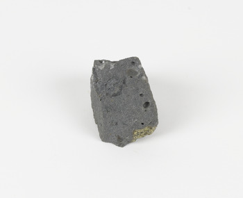
Geological specimen - Basalt (igneous-volcanic) containing Olivine, unknown
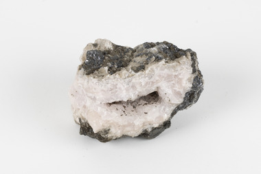
... survey with that of the United States of America as the best in the world. During his years spent in Australia, Selwyn collected numerous significant geological specimens, examples of which are held in collections such as the Burke Museum. This geological specimen is an example of basalt and olivine which shows the volcanic lava activity and geographical specific nature of Mt Franklin as a significant volcanic site. According to Agriculture ...This particular geological specimen was found in Mount Franklin or Lalgambook in Djadjawurrung, located between Daylesford and Newstead, approximately ninety minutes drive from Melbourne. The mountain is an example of a breached scoria cone (a steep conical hill of loose pyroclastic fragments) which was created by a volcanic eruption about 470,000 years ago, a date which may indicate the age of this geological specimen. The volcanic eruptions of Mount Franklin were most likely witnessed by members of the Dja Dja Wurrung Aboriginal tribe, who referred to this country as the 'smoking grounds'. Mount Franklin and the surrounding area appears to have been a place of considerable religious significance to Aboriginal people, there is evidence which indicates that frequent large ceremonial gatherings took place in the area. Basalt is the most common rock on Earth’s surface, more than 90% of all volcanic rock on Earth is basalt. Basalt is an aphanitic extrusive igneous rock formed from the rapid cooling of low-viscosity lava exposed at or very near the surface of a rocky planet or moon. Specimens are black in colour and weather to dark green or brown. Basalt is rich in iron and magnesium and is mainly composed of olivine, pyroxene, and plagioclase. Olivine is the name of a group of rock-forming silicate minerals with compositions ranging between Mg2SiO4 and Fe2SiO4. Unlike other minerals, Olivine has a very high crystallisation temperature which makes it the first of the minerals to crystallise from magma. As magma cools, the crystals begin to form and settle on the bottom of the lava and form basalts that are abnormally enriched in olivine in the lower part of lava flows. According to H. M. King (on geology.com) "Olivine is thought to be an important mineral in Earth's mantle. Its presence as a mantle mineral has been inferred by a change in the behaviour of seismic waves as they cross the boundary between Earth's crust and mantle". Lava from Mount Franklin and other volcanoes in the area filled valleys and buried the gold bearing streams that became the renowned ‘deep leads’ of the gold mining era. In 1852, as part of the Victorian gold rush, gold was discovered in the immediate area, this gold was created by lava flows during the Newer Volcanic period, which were mined intensively during the nineteenth century. Around 1865 the presence of a deep lead in Mount Franklin was established. Deep lead mining was initially unsuccessful, and it was not until the late 1870s that the Franklinford Gold Mining Company mined at Mount Franklin on a significant scale. A few years later the Mount Franklin Estate Gold Mining Company also struck gold, followed by the Shakespeare and Great Western companies in the mid-1880s. By the late 1880s, however, deep lead mining had ceased in the area. Soon after gold was discovered in 1851, Victoria’s Governor La Trobe wrote to the Colonial Office in London, urging ‘the propriety of selecting and appointing as Mineral Surveyor for this Colony a gentleman possessed of the requisite qualifications and acquaintance with geological science and phenomena’. Alfred Selwyn was appointed geological surveyor in Australia in 1852 which began the Geological Survey of Victoria. In 1853-69 the Geological Survey issued under Selwyn's direction sixty-one geological maps and numerous reports; they were of such high standard that a writer in the Quarterly Journal of the Geological Society of London bracketed the survey with that of the United States of America as the best in the world. During his years spent in Australia, Selwyn collected numerous significant geological specimens, examples of which are held in collections such as the Burke Museum.This geological specimen is an example of basalt and olivine which shows the volcanic lava activity and geographical specific nature of Mt Franklin as a significant volcanic site. According to Agriculture Victoria 'The crater is one of the deepest in the Central Highlands area. It is a major megacryst site with some of the largest known Victorian examples of megacrysts of augite and an orthoclase. The small parasitic mound of Lady Franklin on the western flanks adds to the geological interest of the site'. This specimen also highlights the locality as a significant place for both indigenous activity and Victorian gold rush era mining practices. This specimen is part of a larger collection of geological and mineral specimens collected from around Australia (and some parts of the world) and donated to the Burke Museum between 1868-1880. A large percentage of these specimens were collected in Victoria as part of the Geological Survey of Victoria that begun in 1852 (in response to the Gold Rush) to study and map the geology of Victoria. Collecting geological specimens was an important part of mapping and understanding the scientific makeup of the earth. Many of these specimens were sent to research and collecting organisations across Australia, including the Burke Museum, to educate and encourage further study.An angular, solid hand-sized piece of grey volcanic Basalt with green/brown Olivine phenocrysts along one flat edge.Olivine in basalt / - label is probably / correct. / C. Willman / 15/4/21burke museum, beechworth, indigo shire, beechworth museum, geological, geological specimen, mineralogy, basalt, igneous rock, igneous-volcanic, volcanic geology, volcanic, olivine, olivine specimen, basaltoid -
 The Beechworth Burke Museum
Geological specimen - Dolomite
... agricultural processes. This specimen was donated to the Burke Museum in 1868 by Alfred Selwyn as part of the Geological Survey of Victoria. ...agricultural processes. This specimen was donated to the Burke Museum in 1868 by Alfred Selwyn as part of the Geological Survey of Victoria. ...Dolomite is a mineral, calcium magnesium carbonate, with the chemical formula CaMg(CO3)2. It is a principle component of various rock types sometimes also referred to as dolomite, including dolostone, dolomitic marble and dolomitic limestone (according to the composition of each type). Dolomite rock is found in sedimentary basins throughout the world, comprising approximately 2% of the Earth's crust. It is formed when lime mud or limestone encounters groundwater containing magnesium. Dolomite can contain elements such as lead, zinc and copper. Dolomite and limestone are used in various construction, landscaping and agricultural processes. This specimen was donated to the Burke Museum in 1868 by Alfred Selwyn as part of the Geological Survey of Victoria. It was donated to the Museum in 1868. Victoria and other regions of Australia were surveyed for sites of potential mineral wealth throughout the 19th Century. The identification of sites containing valuable commodities such as gold, iron ore and gemstones in a locality had the potential to shape the development and history of communities and industries in the area. The discovery of gold in Victoria, for instance, had a significant influence on the development of the area now known as 'the goldfields', including Beechworth; the city of Melbourne and Victoria as a whole. Dolomite and limestone are mined at several locations in Victoria, including sites in the North-East of the state in Bindi and Limestone Creek. There are notable dolomite deposits in most Australian states. The dolomitised form of the mineral tends to come from older limestone deposits, formed during the palaeozoic era in marine settings, so this specimen may have come from a deposit located along a coastline in Victoria or another state. The specimen is significant as an example of surveying activity undertaken to assess and direct the development of the mineral resource industries in Victoria and Australia, as well as the movement to expand human knowledge of earth sciences such as mineralogy and geology in the nineteenth century. This specimen is part of a larger collection of geological and mineral specimens collected from around Australia (and some parts of the world) and donated to the Burke Museum between 1868-1880. A large percentage of these specimens were collected in Victoria as part of the Geological Survey of Victoria that begun in 1852 (in response to the Gold Rush) to study and map the geology of Victoria. Collecting geological specimens was an important part of mapping and understanding the scientific makeup of the earth. Many of these specimens were sent to research and collecting organisations across Australia, including the Burke Museum, to educate and encourage further study.Hand-sized piece of pale pink dolomite (calcium magnesium carbonate) with dark grey rim and hollowed centre. geological specimen, geology, geology collection, burke museum, beechworth, dolomite, mineralogy, geological survey, alfred selwyn, limestone, calcium magnesium carbonate -
 Phillip Island and District Historical Society Inc.
Photograph, Re-enactment of Churchill Island landing 2001, 2001
... In 1801, Lieutenant James Grant of the British survey vessel Lady Nelson landed on Churchill Island, clearing land to plant the first European agricultural crops in Victoria, namely corn and wheat. ...Phillip Island and District Historical Society Inc. phillip-island-and-the-bass-coast In 1801, Lieutenant James Grant of the British survey vessel Lady Nelson landed on Churchill Island, clearing land to plant the first European agricultural crops in Victoria, namely corn and wheat. ...In 1801, Lieutenant James Grant of the British survey vessel Lady Nelson landed on Churchill Island, clearing land to plant the first European agricultural crops in Victoria, namely corn and wheat. Re-enactment in 2001.HistoricalNine coloured [ 10x15 cms] photos showing people dressed in historical costumes as members of the landing party and the sailing ship replica, Lady Nelson.churchill island, sailing ship - lady nelson, don coleshill, russell broadbent, kath eddy, cherry mcfee -
Bendigo Historical Society Inc.
Map - YARRABERB : COUNTY OF BENDIGO, 23-2-15
... agricultural lands By authority Albert J. Mullett, Government Printer. Map. Yarraberb, County of Bendigo, Salisbury, Yallook, Neilborough, Nerring, Leichardt, Bridgewater. L5373. Photographed at the Department of Lands and Survey ...Map. Yarraberb, County of Bendigo, Salisbury, Yallook, Neilborough, Nerring, Leichardt, Bridgewater. L5373. Photographed at the Department of Lands and Survey, Melbourne by W.J. Butson 23-2-15. Price 1/-.By authority: Albert J. Mullett, Government Printer, Melbourne. (number 16 in map cupboard 1)By authority Albert J. Mullett, Government Printer.map, bendigo, agricultural lands -
Bendigo Historical Society Inc.
Map - YARRABERB : COUNTY OF BENDIGO, 2-3-51
... agricultural lands H.J. Green, Govt. Printer Map. Yarraberb, County of Bendigo, Salisbury, Yallook, Neilborough, Nerring, Leichardt, Bridgewater. L5373. By authority H.J. Green, Govt. Printer,Photo-Lithographed at the Deptartment of Lands and Survey ...Map. Yarraberb, County of Bendigo, Salisbury, Yallook, Neilborough, Nerring, Leichardt, Bridgewater. L5373. By authority H.J. Green, Govt. Printer,Photo-Lithographed at the Deptartment of Lands and Survey, Melbourne. Price 2/-.2-3-51. (number 15 in map cupboard 1)H.J. Green, Govt. Printermap, bendigo, agricultural lands -
Bendigo Historical Society Inc.
Map - CAMPBELL COLLECTION: BENDIGO AND DISTRICT MAPS, 11-2-37
... agricultural lands H.J. Green, Government Printer Map. Parish of Shelbourne, County of Bendigo. Scale 40 chains to 1 inch. Drawn and reproduced at the Department of Lands and Survey, Melbourne, Victoria. ...Map. Parish of Shelbourne, County of Bendigo. Scale 40 chains to 1 inch. Drawn and reproduced at the Department of Lands and Survey, Melbourne, Victoria. Price 2/-.11-2-37. By Authority H.J. Green, Government Printer, Melbourne.H.J. Green, Government Printermap, bendigo, agricultural lands -
Bendigo Historical Society Inc.
Map - CAMPBELL COLLECTION: BENDIGO AND DISTRICT MAPS, June 1953
... agricultural lands W.M. Houston, Government Printer. Map. Marong, County of Bendigo, Scale 40 chains to 1 inch. Woodstock, Leichardt, Nerring, Sandhurst, Lockwood, Shelbourne. Drawn and reproduced at the Department of Lands and Survey ...Map. Marong, County of Bendigo, Scale 40 chains to 1 inch. Woodstock, Leichardt, Nerring, Sandhurst, Lockwood, Shelbourne. Drawn and reproduced at the Department of Lands and Survey, Melbourne, Victoria. By Authority : W.M. Houston, Government Printer. June 1953. Price 2/-. (number 403 in map cupboard 1)W.M. Houston, Government Printer.map, bendigo, agricultural lands -
 City of Moorabbin Historical Society (Operating the Box Cottage Museum)
Farm Equipment, Rake, large Hay c1900, c1900
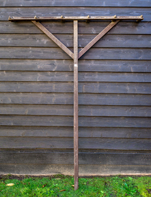
... agricultural rake used to collect cut hay or straw into windrows for later collection (e.g. by a baler or a loader wagon). It is also designed to fluff up the hay and turn it over so that it may dry. The next day it is spread again, so that the hay dries more quickly. Early settlers established productive market gardens, poultry,. pig and dairy farms , orchards and vineyards on the land in the 'Henry Dendy Special Survey...agricultural rake used to collect cut hay or straw into windrows for later collection (e.g. by a baler or a loader wagon). It is also designed to fluff up the hay and turn it over so that it may dry. The next day it is spread again, so that the hay dries more quickly. Early settlers established productive market gardens, poultry,. pig and dairy farms , orchards and vineyards on the land in the 'Henry Dendy Special Survey ...A hay rake is an agricultural rake used to collect cut hay or straw into windrows for later collection (e.g. by a baler or a loader wagon). It is also designed to fluff up the hay and turn it over so that it may dry. The next day it is spread again, so that the hay dries more quickly. Early settlers established productive market gardens, poultry,. pig and dairy farms , orchards and vineyards on the land in the 'Henry Dendy Special Survey Brighton 1841' - now Ormond, Bentleigh, East Bentleigh, Brighton, This hay rake is typical of the type used by early settlers in Moorabbin Shire c1900Large wooden Hay rake , hand made c1900farm equipment, hay rakes, hammers, early settlers, market gardeners, blacksmiths, tools, building equipment, moorabbin shire, bentleigh, mckinnon, highett, cheltenham,ormond -
 City of Moorabbin Historical Society (Operating the Box Cottage Museum)
Photograph, B&W Jessie Melinda Box 1888 - 1975, c1889
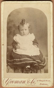
... A B Leigh * box george, box mary, box william, box elizabeth honor, box alonzo, box mary louisa, dendy henry, were j b, dendy's special survey 1841, brighton, moorabbin, bentleigh, mckinnon, ormond, market gardeners, dairy farms, early settlers, pioneers, tucker road, box francis , thompson eliza jane, box william henry george, box charles francis, , box mabel alma. box jessie melinda, robinson william, robinson jack francis, robinson william james, poll hereford stud farming, rowville, mornington, notting hill victoria, royal melbourne agricultural show, royal sydney agricultural show. cattle breeding, YEOMAN & Co 47 Chapel Street, / Prahran A black and white photograph of Jessie Melinda Box a daughter of Francis Box and Elizabeth Jane Thompson Box c 1889 Photograph, B&W Jessie Melinda Box 1888 - 1975 Yeoman & Co ...Francis Box was born in Withyham, Sussex and came to Australia with his parents George and Mary Box and siblings in 1856. He was assigned to work in Beaufort and had various jobs including ‘gold miner’ at Heathcoat where he married Eliza Jane Thompson. Francis decided to return to market gardening after the death of his 1st child Francis George Box in 1875 aged 13months. The child was buried in Brighton Cemetery and Francis then rent/leased the land on the corner of Tucker Road and Elizabeth Street East Brighton ( now Bentleigh) owned by his brother Henry who with another brother John helped Francis clear the land, and establish a market garden. They had 4 children and began to prosper until in 1882 their 2year old child Lena Caroline Box was killed in a fire that destroyed their house. Francis was burned trying to rescue the child. The local community raised money to assist the family. The land boom brought prosperity again and Francis bought more land around Tucker Road which was bequeathed to his children. Francis and Eliza Jane had four more children but one died in infancy and another aged 2 years. Only 5 of their 9 children survived. Francis and Eliza Jane, who died in 1922, are also buried in Brighton Cemetery Jessie Melinda Box 1888- 1975 was born in East Brighton ( Bentleigh) the 8th child of Francis and Eliza Jane Box. She was a teacher in Eskdale, Victoria and married William Robinson d 1983, a farmer at Mitta in 1921. The family later moved to Tucker Road, Bentleigh where they ran a market garden until in 1950 they established "The Hilandale Poll Hereford Stud" at Notting Hill and Rowville. They moved to Mornington c 1960 where they continued their stud farming and enjoyed success at Melbourne, Sydney and local Shows. They had 2 children Jack Francis Robinson b1921, William James Robinson b1925. Box Cottage Museum, a reconstruction of an early settler hut, is named after the Box family who resided there 1865 -1913 . William Box who with his wife Elizabeth Avis Box and 13 children lived and farmed on the block of land in Jasper Road, East Brighton ( now McKinnon / Ormond) that was part of the Henry Dendy Special Survey 1841 . Francis Box, a brother of William Box, was born in Withyham, Sussex and came to Australia with his parents George and Mary Box and siblings in 1856. Francis established market gardens in Tucker Road Bentleigh. Jessie melinda Box was the 8th child of Francis Box Inscribed in Album “ The early photos in this album were found by Mr (Laurie) Lewis when he was demolishing the Old Box Cottage. He gave them to Mrs Avis Box Eldridge who in turn gave them to me. They were not identified. I believe they rightly belong in the Cottage. I have attempted to identify them and present them in a way they can be preserved as a historical record of the era.” A B Leigh A black and white photograph of Jessie Melinda Box a daughter of Francis Box and Elizabeth Jane Thompson Box c 1889YEOMAN & Co 47 Chapel Street, / Prahran* box george, box mary, box william, box elizabeth honor, box alonzo, box mary louisa, dendy henry, were j b, dendy's special survey 1841, brighton, moorabbin, bentleigh, mckinnon, ormond, market gardeners, dairy farms, early settlers, pioneers, tucker road, box francis , thompson eliza jane, box william henry george, box charles francis, , box mabel alma. box jessie melinda, robinson william, robinson jack francis, robinson william james, poll hereford stud farming, rowville, mornington, notting hill victoria, royal melbourne agricultural show, royal sydney agricultural show. cattle breeding, -
 City of Moorabbin Historical Society (Operating the Box Cottage Museum)
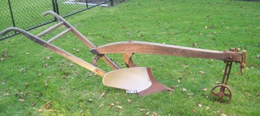
Machine - Farm Machinery, Plough, single mull-board, c1900
... agricultural implement used by the pioneer market gardeners, in Moorabbin Shire, of the 1800s and continued on into the 1940s when motorised tractors came into use. This plough is an example of a single-mullboard plough which would have been pulled by horse. The long handle was used to lower the silver plate, (mullboard), to the chosen depth of soil. Following 'Dendy's Special Survey ...Circa late 1800's to early 1900s. A horse-drawn furrow plough was the most common type of agricultural implement used by the pioneer market gardeners, in Moorabbin Shire, of the 1800s and continued on into the 1940s when motorised tractors came into use. This plough is an example of a single-mullboard plough which would have been pulled by horse. The long handle was used to lower the silver plate, (mullboard), to the chosen depth of soil. Following 'Dendy's Special Survey' of 1841 and the Crown Land Sale in 1852, land allotments were bought by pioneer settlers who established or rented allotments for market gardens in the area and they supplied produce to the markets in St Kilda and Melbourne. During the gold-rush of the 1850s the rapidly increasing population of Melbourne saw a huge demand and a rise in prices for all foodstuffs, including the vegetables and fruit grown in the Shire of Moorabbin. An "Oliver" single mull-board plough in good condition with faded manufactures markings on shaftsPainted on shaft "MANF'D BY/OLIVER CHILLED PLOW WORKS/Southend Ind. USA/" Engraved on blade " 13 OLIVER"brighton, moorabbin, plough, dendy henry, east bentleigh, market gardens, horse drawn plough, plow, mullboard -
 Glenelg Shire Council Cultural Collection
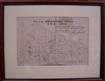
Map - Map of Drik-Drik, 1865
... Front: Plan of the Agricultural Area of Drik-Drik L.2556/Prepared by the Board of Lands and Works in accordance with the "Amending Land Act 1865". Lands and Survey...Glenelg Shire Council Cultural Collection History House Cliff Street Portland great-ocean-road Displayed at History House. map drik drik plan geography cartography Front: Plan of the Agricultural Area of Drik-Drik L.2556/Prepared by the Board of Lands and Works in accordance with the "Amending Land Act 1865". Lands and Survey ...Displayed at History House.Print of map pasted onto board, mounted and framed under glass. Buff-coloured mount. Mahogany stained moulded wood frame, black inner frame.Front: Plan of the Agricultural Area of Drik-Drik L.2556/Prepared by the Board of Lands and Works in accordance with the "Amending Land Act 1865". Lands and Survey Office, Melbourne 11th May 1865. (printed, upper centre). Back: Duncan Hedditchmap, drik drik, plan, geography, cartography