Showing 99 items matching "aircraft navigation"
-
 Moorabbin Air Museum
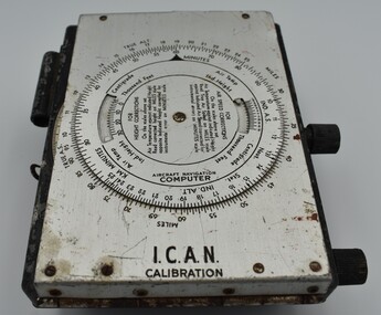
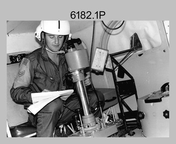
Instrument (item) - Aircraft Navigation Computer I.C.A.N Calibration
... Aircraft Navigation Computer I.C.A.N Calibration...Aircraft Navigation Computer I.C.A.N Calibration...Aircraft Navigation Computer I.C.A.N Calibration...Aircraft Navigation Computer I.C.A.N Calibration Aircraft Navigation Computer I.C.A.N Calibration Instrument Aircraft Navigation Computer I.C.A.N Calibration ... -
 Moorabbin Air Museum
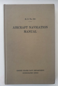
Manual (Item) - H.O.No.216 Aircraft Navigation Manual; United States Navy Department Hydrographic Office, Aircraft Navigation Manual United States Navy
... H.O.No.216 Aircraft Navigation Manual; United States Navy Department Hydrographic Office...Aircraft Navigation Manual United States Navy......Aircraft Navigation...While the Second World War had broken out, the United States where yet to join World War Two United States Navy Aircraft Navigation Aircraft Navigation Manual United States Navy Manual H.O.No.216 Aircraft Navigation Manual; United States Navy Department Hydrographic Office ...Produced by the United States Navy during 1940. While the Second World War had broken out, the United States where yet to joinworld war two, united states navy, aircraft navigation -
 Moorabbin Air Museum
Book (Item) - Aircraft Navigation 16th Technical Conference. Miami, April 22-30.1965.Summary Of Proceedings
... Aircraft Navigation 16th Technical Conference. Miami, April 22-30.1965.Summary Of Proceedings....Aircraft Navigation 16th Technical Conference. Miami, April 22-30.1965.Summary Of Proceedings....Book Aircraft Navigation 16th Technical Conference. Miami, April 22-30.1965.Summary Of Proceedings. ... -
Moorabbin Air Museum
Book (Item) - Aircraft Navigation Part 1: Theory
... Aircraft Navigation Part 1: Theory...Aircraft Navigation Part 1: Theory...Moorabbin Air Museum Moorabbin Airport 12 First Street Moorabbin melbourne Aircraft Navigation Part 1: Theory Book Aircraft Navigation Part 1: Theory ... -
Moorabbin Air Museum
Book - Aerial navigation, Flight - Meteorology, Aircraft Instruments and Navigation
... Flight - Meteorology, Aircraft Instruments and Navigation......Aircraft instruments...Aerial navigation...Moorabbin Air Museum Moorabbin Airport 12 First Street Moorabbin melbourne Aerial navigation Atmosphere Weather map Airway weather service Aerial photogrophy Aviation radio Aircraft instruments Aerial navigation Overview of basic meteorology , aircraft instrumentation & navigation, circa 1943 Flight - Meteorology, Aircraft Instruments and Navigation Book Aerial navigation ...Overview of basic meteorology , aircraft instrumentation & navigation, circa 1943non-fictionOverview of basic meteorology , aircraft instrumentation & navigation, circa 1943atmosphere, weather map, airway weather service, aerial photogrophy, aviation radio, aircraft instruments, aerial navigation -
Moorabbin Air Museum
Book - Air Navigation, Aircraft Navigation Aids
... Aircraft Navigation Aids...Moorabbin Air Museum Moorabbin Airport 12 First Street Moorabbin melbourne Air Navigation Overview of air navigation aids for civil aircraft, circa 1968 Aircraft Navigation Aids Book Air Navigation ...Overview of air navigation aids for civil aircraft, circa 1968Overview of air navigation aids for civil aircraft, circa 1968 -
Moorabbin Air Museum
Manual - Trans Australia Airlines training manuals, TAA Boeing 727 - 200 Aircraft Navigation and Auto - Flight
... TAA Boeing 727 - 200 Aircraft Navigation and Auto - Flight...Moorabbin Air Museum Moorabbin Airport 12 First Street Moorabbin melbourne TAA Technical manuals Overview of TAA navigation & auto flight systems on TAA Boeing 727 - 200 airliners, circa 1980 Spiral bound manual with missing front cover TAA Boeing 727 - 200 Aircraft Navigation and Auto - Flight Manual Trans Australia Airlines training manuals ...Overview of TAA navigation & auto flight systems on TAA Boeing 727 - 200 airliners, circa 1980Spiral bound manual with missing front covernon-fictionOverview of TAA navigation & auto flight systems on TAA Boeing 727 - 200 airliners, circa 1980 -
 Wangaratta RSL Sub Branch
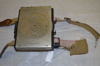
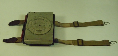
Instrument - Aircraft Navigation Computer
... Aircraft Navigation Computer...navigation...raaf...computer...aircraft...The navigational computer was a circular slide rule used for calculating height and air speed corrections when flying an aircraft. ...Instrument Aircraft Navigation Computer ...The navigational computer was a circular slide rule used for calculating height and air speed corrections when flying an aircraft. The front cover lifts to reveal a further calculator used to solve vector triangles and plot course alterations. The device was intended to be strapped to a pilot's leg. The instrument was made by White and Gillespie (Melbourne) Pty Ltd c 1940 for the RAAF and used during WW2.Black metal box with silver metal flap top cover affixed with rotating circular rule . Two adjustable belts are affixed to the base of black box. A small spiral bound note book is contained beneath the flap top. RAAF Computer Navigational system MK. III. D. Serial No WG 2833navigation, raaf, computer, aircraft, ww2, 1940 -
Moorabbin Air Museum
Manual - Aircraft navigation systems, Very Low Frequency Navigation Systems
... Aircraft navigation systems...Moorabbin Air Museum Moorabbin Airport 12 First Street Moorabbin melbourne Hyperbolic navigation systems Navigation terms GNS-500A series 3 maintenance Collection of hand written & printed notes on low frequency navigation systems, circa 1985 3 ring folder Very Low Frequency Navigation Systems Manual Aircraft navigation systems ...Collection of hand written & printed notes on low frequency navigation systems, circa 19853 ring foldernon-fictionCollection of hand written & printed notes on low frequency navigation systems, circa 1985hyperbolic navigation systems, navigation terms, gns-500a series 3 maintenance -
 Moorabbin Air Museum
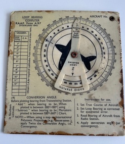
Instrument (item) - Loop Bearing Computer RAAF Form A97
... Loop Bearing Computer RAAF Form A97,used for aircraft navigation....Moorabbin Air Museum Moorabbin Airport 12 First Street Moorabbin melbourne Loop Bearing Computer RAAF Form A97,used for aircraft navigation. Instrument Loop Bearing Computer RAAF Form A97 ... -
Moorabbin Air Museum
Manual - Private Pilots Licence Courses, Private Pilot Course Navigation and Flight Planning
... Aircraft Navigation...Moorabbin Air Museum Moorabbin Airport 12 First Street Moorabbin melbourne Aircraft Navigation Study guide of navigation & flight planning for private pilot students Spiral bound manual Private Pilot Course Navigation and Flight Planning Manual Private Pilots Licence Courses ...Study guide of navigation & flight planning for private pilot studentsSpiral bound manualnon-fictionStudy guide of navigation & flight planning for private pilot studentsaircraft navigation -
Moorabbin Air Museum
Book - Aviation training, The Private Pilot
... ...Aircraft Navigation...Moorabbin Air Museum Moorabbin Airport 12 First Street Moorabbin melbourne Aviation training Principles of flight Engines Aircraft Navigation Meteorology Training manual for private pilots, circa 1967 The Private Pilot Book Aviation training ...Training manual for private pilots, circa 1967non-fictionTraining manual for private pilots, circa 1967principles of flight, engines, aircraft navigation, meteorology -
Moorabbin Air Museum
Manual (Item) - Porter Aircraft Communications And Radio Navigation Systems Maintenance Manual
... Porter Aircraft Communications And Radio Navigation Systems Maintenance Manual...Manual Porter Aircraft Communications And Radio Navigation Systems Maintenance Manual ...Description: Published 1/5/61. Published by Piper Aircraft Corporation. 256 pages. Piper PA23 Apache Aircraft Service Manual Level of Importance: World. -
 Moorabbin Air Museum
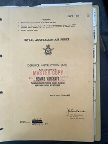
Manual (item) - (SP) AAP 7211.016-2-6 Nomad Aircraft Communications and Radio Navigation Systems
... (SP) AAP 7211.016-2-6 Nomad Aircraft Communications and Radio Navigation Systems...Moorabbin Air Museum Moorabbin Airport 12 First Street Moorabbin melbourne Manual (SP) AAP 7211.016-2-6 Nomad Aircraft Communications and Radio Navigation Systems ... -
Moorabbin Air Museum
Book - Aviation training, The Commercial Pilot
... ...Air navigation...Aircraft...Moorabbin Air Museum Moorabbin Airport 12 First Street Moorabbin melbourne Aviation training Principles of flight Air navigation Aircraft engines Air frames Overview of theory requirements for Commercial Pilot Licence exam, circa 1965 The Commercial Pilot Book Aviation training ...Overview of theory requirements for Commercial Pilot Licence exam, circa 1965non-fictionOverview of theory requirements for Commercial Pilot Licence exam, circa 1965principles of flight, air navigation, aircraft engines, air frames -
Moorabbin Air Museum
Book - Commercial pilot training, The Commercial Pilot
... ...Air navigation...Aircraft...Moorabbin Air Museum Moorabbin Airport 12 First Street Moorabbin melbourne Commercial pilot training Principles of flight Air navigation Aircraft engines Air frames Aircraft performance and operation Overview of theory requirements of commercial pilot's exam, circa 1972 The Commercial Pilot Book Commercial pilot training ...Overview of theory requirements of commercial pilot's exam, circa 1972non-fictionOverview of theory requirements of commercial pilot's exam, circa 1972principles of flight, air navigation, aircraft engines, air frames, aircraft performance and operation -
 B-24 Liberator Memorial Restoration Australia Inc
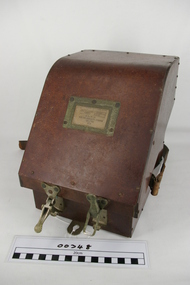
Computer Navigational MkIII D, White & Gillespie (Melb) Pty Ltd, c. 1940
... RAAF Manual navigation aircraft calculator(early computer)...B-24 Liberator Memorial Restoration Australia Inc Corner Farm Rd & Princes Highway Werribee melbourne RAAF Manual navigation aircraft calculator(early computer) General issue to allied pilots and navigators for airspeed,altitude,air temperature and drift calculations. ...RAAF Manual navigation aircraft calculator(early computer)General issue to allied pilots and navigators for airspeed,altitude,air temperature and drift calculations.Black metal box with SS flap-top cover, moulding and straps for knee attachment.Engraving No. 19, Ident.No. G6B/145. I.C.A.N. Serial No. WG/1716*. Computer Navigational Mk.IIID -
 Nhill Aviation Heritage Centre
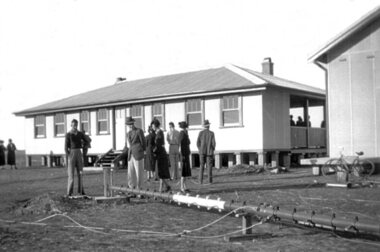
Black and white photograph, Local photograph. Original of this scan held by Nhill Historical Society, Aeradio Building c1937
... The building and its equipment were part of a comprehensive system of radio towers, signalling and meteorology equipment aimed at providing safer navigation for aircraft travelling throughout Australia. ...The building and its equipment were part of a comprehensive system of radio towers lights and signalling equipment aimed at providing safer navigation for aircraft travelling throughout Australia. ...The building and its equipment were part of a comprehensive system of radio towers, signalling and meteorology equipment aimed at providing safer navigation for aircraft travelling throughout Australia. ...This building is still intact at the Nhill Aerodrome. Some of the infrastructure is also in place or can be evidenced by its foundations.The Aeradio building was built on the present aerodrome in 1937. This was one of only sixteen buildings of this type built across Australia and it housed radio communications and guidance equipment. The building and its equipment were part of a comprehensive system of radio towers, signalling and meteorology equipment aimed at providing safer navigation for aircraft travelling throughout Australia. The facility closed in the 1960sThis photo is significant due to it having been taken soon after the building was constructed. It is the earliest known photograph taken on an open to the public day before the receiver aerials were erected.The Aeradio building was built on the present (2012) aerodrome in 1937 or 1938. This was one of only fifteen buildings of this type built across Australia and it housed radio communications and guidance equipment. The building and its equipment were part of a comprehensive system of radio towers lights and signalling equipment aimed at providing safer navigation for aircraft travelling throughout Australia. The facility closed in the 1960sphoto, aeradio, early, civil aviation, dca, dept of civil aviation -
 Orbost & District Historical Society
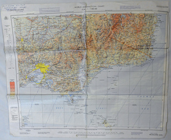
map, 1985
... An aeronautical chart is a map designed to assist in navigation of aircraft. Using these charts and other tools, pilots are able to determine their position, safe altitude, best route to a destination, navigation aids along the way, alternative landing areas in case of an in-flight emergency, and other useful information such as radio frequencies and airspace boundaries. ...Orbost & District Historical Society Ruskin Street Orbost gippsland An aeronautical chart is a map designed to assist in navigation of aircraft. Using these charts and other tools, pilots are able to determine their position, safe altitude, best route to a destination, navigation aids along the way, alternative landing areas in case of an in-flight emergency, and other useful information such as radio frequencies and airspace boundaries. ...An aeronautical chart is a map designed to assist in navigation of aircraft. Using these charts and other tools, pilots are able to determine their position, safe altitude, best route to a destination, navigation aids along the way, alternative landing areas in case of an in-flight emergency, and other useful information such as radio frequencies and airspace boundaries. World aeronautical charts have a scale of 1:1,000,000 and cover relatively large areas. Orbost Aero Club began in 1969 with Basil Dowie as Chair, David Nixon as Secretary/Treasurer. The group went into recess from 1977-1991 closing in 1997. The mid 1960s were boom years in flying training in Australia and the number of Aero Clubs grew rapidly. The Club played a significant role in the establishment of the small airport at Marlo and in the ongoing operation and development of the airport over the years particularly for patient transfer by aerial ambulance. The Orbost Aero Club Club played a significant role in the establishment of the small airport at Marlo and in the ongoing operation and development of the airport over the years.A laminated map of eastern Victoria. A World Aeronautical Chart. It shows elevations, longitude etc and is designed for pre-flight planning as well as pilotage. Top left hand corner - D.F.N.Nixon VH-FWD 12 Kristine Ct Cheletenham 27/7/87orbost-aero-club aeronautical-map -
 Bendigo Military Museum
Map - RASvy " Map Makers Exhibition 2025 "- Map display, RAN Hydrographic Office, 1972 - 1992
... navigation beacons and obstructions. Contours and height information was shown in feet to be compatible with aircraft altimeters. ...navigation beacons and obstructions. Contours and height information was shown in feet to be compatible with aircraft altimeters. ...All of these Charts / Maps were used for the RSL Museum display " The Mapmakers " ( of RASvy. ) 10 Jun - 10 Aug 2025. .1 Catalogue of Tactical Pilotage Charts, 1:500 000 Scale. Digital Data Base available as at 30Jun 92. This catalogue page shows the extent of the Australian area of responsibility for aeronautical charting. .2 RAAF PLOTTING CHART. NP 22-2 (Navigational Plotting) Tasmania. MERCATOR PROJECTION. This series of charts were used for the training of RAAF Navigators. These charts were produced and printed at the Army Survey Regiment, Bendigo. .3 RAAF PLOTTING CHART AUSTRALIA - SOUTHEAST. NP 27 is Based on LAMBERT CONFORMAL CONIC PROJECTION. This series of charts was used by RAAF Navigators for the planning of RAAF flights. These charts were produced and printed at the Army Survey Regiment, Bendigo. .4 RAAF LONG RANGE PLOTTING CHART. NP 43-4 AUSTRALIA WESTERN. MERCATOR PROJECTION. This series of maps were used for the planning of RAAF flights. Of Particular note these charts were used to plot "Rhumb Lines or loxodromes" where a course crosses all Meridians (Lines of latitude and longitude) at the same angle. On Mercator projection charts Rhumb lines are conveniently shown as straight lines and are also lines of constant compass bearing. Rhumb lines are usually longer than the shortest distance between two points. The shortest distance between two points on the earth's surface is called a "Great Circle Route" which is a route on a circular path on the surface of the earth where the centre of that circle is also the centre of the earth. Great Circle Routes on a Mercator Projection are however curves and harder to plot. These charts were produced and printed at the Army Survey Regiment, Bendigo. .5 RAAF LONG RANGE PLOTTING CHART. NP 43-7 SOLOMON ISLANDS. MERCATOR PROJECTION. Used for the planning of RAAF flights. .6 RAAF AIR STAFF PLANNING CHART NS 137-1 DARWIN NORTH WEST. AZIMUTHAL EQUIDISTANT PROJECTION. This series of charts were used for planning by the staff. The whole chart was produced by joining the four quadrant maps together. The charts are based on a single point of tangency (in this case Darwin) and shows radius (distance) in nautical miles to and from that point. A series of charts were produced centred on each of the major airfields in Northern Australia. These charts were produced and printed at the Army Survey Regiment, Bendigo. .7 RAAF AIR STAFF PLANNING CHART NS 137-2 DARWIN NORTH EAST. AZIMUTHAL EQUIDISTANT PROJECTION. Used for the planning by the staff. The charts are based on a point of tangency and show radius in nautical miles. .8 RAAF AIR STAFF PLANNING CHART NS 137-4 DARWIN SOUTH WEST. AZIMUTHAL EQUIDISTANT PROJECTION. Used for the planning by the staff. The charts are based on a point of tangency and show radius in nautical miles. .9 RAAF AIR STAFF PLANNING CHART NS 137-3 DARWIN SOUTH EAST. AZIMUTHAL EQUIDISTANT PROJECTION. Used for the planning by the staff. The charts are based on a point of tangency and show radius in nautical miles. .10 TACTICAL PILOTAGE CHART. TPC R-13B. LAMBERT CONFORMAL PROJECTION. Used by pilots for flight planning and could be used in flight if necessary for visual navigation using major ground features shown on the chart. These charts also contained aeronautical information such as airfields, radio navigation beacons and obstructions. Contours and height information was shown in feet to be compatible with aircraft altimeters. Each graticule square also contained a Maximum Safe Elevation Figure (MEF) also in feet. Coverage of this series over Australia's area of interest were produced and printed at the Army Survey Regiment, Bendigo. .11 HYDROGRAPHIC CHART. AUS 158. PORT PHILLIP SOUTH and WEST CHANNELS. PROJECTION TRANSVERSE MERCATOR. Used by all people needing to navigate a vessel. Hydrographic charts were printed at the Army Survey Regiment, Bendigo. .12 HYDROGRAPHIC CHART. AUS 157. GEELONG HARBOUR and APPROACHES. PROJECTION TRANSVERSE MERCATOR. Used by all people needing to navigate a vessel. .13 EN ROUTE CHART. AUSTRALIA ERC HIGH. H1 and H2. LAMBERT CONFORMAL CONIC PROJECTION. This series of charts were regularly produced by the RAAF Aeronautical Information Service (AIS) and contained current aeronautical information for pilots. These charts were printed at the Army Survey Regiment, Bendigo..1 Tactical Pilotage Chart Series Catalogue. Current as at 30 Jun 92. .2 Extract of Navigational Plotting Chart " NP22-2 Tasmania " .3 Extract of Navigational Plotting Chart " NP 27 RAAF PLOTTING CHART AUSTRALIA - SOUTHEAST " .4 Extract of Navigational Plotting Chart " RAAF LONG RANGE PLOTTING CHART NP43-4 AUSTRALIA WESTERN " .5 Extract of Navigational Plotting Chart " RAAF LONG RANGE PLOTTING CHART NP43-7 SOLOMON ISLANDS " .6 Extract of Navigational Series " RAAF AIR STAFF PLANNING CHART NS 137-2 DARWIN NORTH WEST " .7 Extract of Navigational Series " RAAF AIR STAFF PLANNING CHART NS 137-1 DARWIN NORTH EAST " .8 Extract of Navigational Series " RAAF AIR STAFF PLANNING CHART NS 137-4 DARWIN SOUTH WEST " .9 Extract of Navigational Series " RAAF AIR STAFF PLANNING CHART NS 137-3 DARWIN SOUTH EAST " .10 Extract of Tactical Pilotage Chart " TPC R-13B " .11 Extract of Hydrographic Chart " PORT PHILLIP SOUTH and WEST CHANNELS " .12 Extract of Hydrographic Chart " GEELONG HARBOUR and APPROACHES " .13 Extract of En Route Chart " AUSTRALIA ERC HIGH " " H1 and H2 " royal australian survey corps, rasvy, fortuna, detachment - army survey regiment, army svy regt, asr -
 Bendigo Military Museum
Photograph - Royal Australian Survey Corps Aerial Surveys, c1980
... Navigation Satellite System – TRANSIT) receivers and computing system provided independent three-dimensional point positions anywhere in the world, anytime, in any weather accurate to about 1.5metres with precise satellite ephemerides. The Bell OH-58 Kiowa LOH was a family of military helicopters used for observation, utility, and direct fire support. It was identified by RA Svy in the mid-1970s that considerable time was lost in replacing unserviceable remote equipment by road. Therefore Aerodist operations (pre-dating satellite receiver operations) were fully supported by Army’s Kiowa LOH aircraft...Navigation Satellite System – TRANSIT) receivers and computing system provided independent three-dimensional point positions anywhere in the world, anytime, in any weather accurate to about 1.5metres with precise satellite ephemerides. The Bell OH-58 Kiowa LOH was a family of military helicopters used for observation, utility, and direct fire support. It was identified by RA Svy in the mid-1970s that considerable time was lost in replacing unserviceable remote equipment by road. Therefore Aerodist operations (pre-dating satellite receiver operations) were fully supported by Army’s Kiowa LOH aircraft ...This is a set of nine photographs of technicians from the Royal Australian Survey Corps operating aerial surveys equipment c1980s. In photo .1P, CPL Steve Gloster was operating a RC10 air survey camera mounted in an Australian Army Pilatus Porter aircraft. The Wild RC10 super wide-angle air survey cameras were first introduced in 1971, were equipped with virtual distortion free lenses for supplementary, spot and special photography. In photo .2P, Roger Rees was operating Air Profile Recorder (APR) equipment. it was possibly taken during OP NERVOSE 84, sometime between June – August 1984 when based in Ngukurr, Northern Territory. The APR was operated at this time in unison with an RC10 camera. In 1963 the Royal Australian Survey Corps introduced the radar airborne profile recorder (Canadian Applied Research Ltd, Mark V, Airborne Profiler Recorder) was introduced for 1:100,000 mapping to replace terrain heighting by aneroid barometry. Later in 1974-1975, the Australian developed WREMAPS II airborne laser terrain profile recorder was introduced. In photo .3P, Neil Jones appears at the door of Airsearch Beechcraft Queen Air aircraft, Registration / Serial VH-MWX. This aircraft was typically used by RA Svy on air survey operations flying mission with Aerodist, APR and RC10 camera equipment. The Australian Army’s Pilatus Porter (short take-off and landing turbo propeller) was also equipped with a Wild RC10 aerial mapping camera for identification photography. The Pilatus Porter was also used on RA Svy’s map field checking operations. Photo .9P was taken at a survey station at an unknown location. In this photo an Australian Army Kiowa Light Observation Helicopter (LOH) is supporting a field survey party undertaking Magnavox AN/PRR-14 portable Doppler satellite observations. The satellite receiver’s antenna is plumbed over the survey ground mark surrounded by white plastic panels. The panels were used to identify the survey station on aerial photography. Introduced in 1974–1975, the Magnavox AN/PRR-14 portable Doppler satellite (US Navy Navigation Satellite System – TRANSIT) receivers and computing system provided independent three-dimensional point positions anywhere in the world, anytime, in any weather accurate to about 1.5metres with precise satellite ephemerides. The Bell OH-58 Kiowa LOH was a family of military helicopters used for observation, utility, and direct fire support. It was identified by RA Svy in the mid-1970s that considerable time was lost in replacing unserviceable remote equipment by road. Therefore Aerodist operations (pre-dating satellite receiver operations) were fully supported by Army’s Kiowa LOH aircraft. This is a set of nine photographs of technicians from the Royal Australian Survey Corps operating aerial surveys equipment c1980s. .1P to .3P, .5P to .9P - Colour and black and white photos on photographic paper and scanned at 300 dpi. .4P - Colour photo on 35mm slide film and scanned at 96 dpi. .1) & .2) - Photo, black & white, c1980s, CPL Steve Gloster operating an RC10 air camera. .3) - Photo, colour, 1984, Roger Rees operating Air Profile Recorder (APR) equipment. .4) - Photo, colour, c1980s, Neil Jones at the door of an Airsearch Beechcraft Queen Air aircraft, typically used by RA Svy on air survey operations. .5) - Photo, colour, c1980s. A Beechcraft King Air aircraft, also used by RA Svy on air survey operations. .6) - Photo, colour, c1980s. An Australian Army Pilatus Porter, used by RA Svy on air survey and map field checking operations. SGT Peter Mustart is possibly in the foreground. .7) to .8) - Photo, colour, c1980s. An Australian Army Pilatus Porter and unidentified personnel, used by RA Svy on air survey and map field checking operations. .9) - Photo, colour, c1980s. An Australian Army Kiowa helicopter supporting a field survey party undertaking Magnavox AN/PRR-14 portable Doppler satellite observations. There are biro marks on photos .4P to .9Proyal australian survey corps, rasvy, army survey regiment, asr, fortuna, aerial surveys -
 Bendigo Military Museum
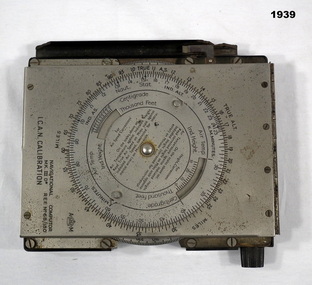
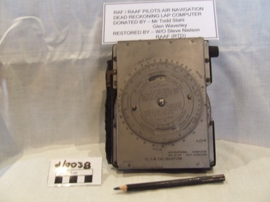
Equipment - COMPUTER, c.1939
... aircraft. Belonged to Maxwell Lennox MATHESON 418447 RAAF. Refer Cat No1959 for his service history. electrical technology appliances & accessories navigational "NAVIGATIONAL Computer MKIID REF No 68/180 ICAN CALIBRATION" NAVIGATIONAL Computer Mark III.D, metal - bakelite, construction rectangular box shape, top lid hinges open. ...Item used by Navigators or Pilots of small aircraft. Belonged to Maxwell Lennox MATHESON 418447 RAAF. Refer Cat No1959 for his service history.NAVIGATIONAL Computer Mark III.D, metal - bakelite, construction rectangular box shape, top lid hinges open. Top lid has a circular adjustment. Inside has another circular adjustment. Centre is a graph in red which winds by a dial on side. Inside top lid hand written in black are items of Navigation."NAVIGATIONAL Computer MKIID REF No 68/180 ICAN CALIBRATION"electrical technology, appliances & accessories, navigational -
 Bendigo Military Museum
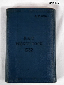
Book - BOOK, RAF, Air Ministry, RAF Pocket Book 1932, 1932
... Booklet contains large amount of information on RAF basic subjects if navigation, liaison signalling, ranks, aircraft markings or worlds air forces, camping, 142 pages. .2) Amendment List No's dated 1933....Booklet contains large amount of information on RAF basic subjects if navigation, liaison signalling, ranks, aircraft markings or worlds air forces, camping, 142 pages. .2) Amendment List No's dated 1933. ....1) Folding, wrap around pocket book, blue buckram. Title is embossed in black ink. Booklet contains large amount of information on RAF basic subjects if navigation, liaison signalling, ranks, aircraft markings or worlds air forces, camping, 142 pages. .2) Amendment List No's dated 1933.Centre: “RAF Pocket Book 1932” Top right: “AP 1081”books-military/reference, military history-air force, raf -
 Bendigo Military Museum
Photograph - 4th Field Survey Squadron – Operation ARIGHT 93, Queensland, 1993
... navigation and to position remote isolated features. Three Bell Kiowa LOH helicopters provided by 162 Recce Sqn supported field checking operations. Supplementary and Vital Asset Protection photography was taken by air camera operators in AAAvn Nomad aircraft from 173 Survl Sqn fitted with an RC10 aerial camera....navigation and to position remote isolated features. Three Bell Kiowa LOH helicopters provided by 162 Recce Sqn supported field checking operations. Supplementary and Vital Asset Protection photography was taken by air camera operators in AAAvn Nomad aircraft from 173 Survl Sqn fitted with an RC10 aerial camera. ...This is a set of 42 photographs taken during 4th Field Survey Squadron’s deployment on Operation ARIGHT 93 in North Queensland from the 30th of August to the 8th of October 1993. The Survey Field Completion area of operations was Weipa near the top end of the Cape York Peninsula. Survey parties conducted field checking of topographic maps covering Bamaga, Heathlands, Weipa, Lockhart River and Strathgordon in Perentie 110 Series Survey variant FFR Land Rovers. Hand-held Trimble and Magellan GPS receivers were used to assist with navigation and to position remote isolated features. Three Bell Kiowa LOH helicopters provided by 162 Recce Sqn supported field checking operations. Supplementary and Vital Asset Protection photography was taken by air camera operators in AAAvn Nomad aircraft from 173 Survl Sqn fitted with an RC10 aerial camera.This is a set of 42 photographs taken in 1993 durin8g 4th Field Survey Squadron’s deployment on Operation ARIGHT in North Queensland. The colour photographs are on 35mm negative film and are part of the Army Survey Regiment’s Collection. The photographs were scanned at 96 dpi. .1) - Photo, colour, 1993. Survey party in Perentie 110 Series Land Rover navigates through Cape York Peninsula sand hills. .2) - Photo, colour, 1993. Cape York Peninsula sand hills. .3) - Photo, colour, 1993. Cape York Peninsula Island. .4) - Photo, colour, 1993. Survey party in Perentie 110 Series Land Rover enters a Cape York Peninsula beach. .5) - Photo, colour, 1993. SPR Kim Baker takes a break on a Cape York Peninsula beach. .6) - Photo, colour, 1993. L to R: MAJ Andy Cordova (USA Exchange) from the Army Survey Regiment and unidentified civilians. .7) to .14) - Photo, colour, 1993. Cape York Peninsula topography. .15) - Photo, colour, 1993. Unidentified surveyor in Bell Kiowa LOH helicopter. .16) - Photo, colour, 1993. Bell Kiowa LOH helicopter circles base camp. .17) to .18) - Photo, colour, 1993. Cape York Peninsula topography. .19) - Photo, colour, 1993. Vehicle convoy taking a break. L to R: LT John Bath (Detachment OC), unidentified (x2), SPR Chris Pearse. .20) - Photo, colour, 1993. Vehicle convoy taking a break. .21) - Photo, colour, 1993. Vehicle convoy ready to go. SPR Chris Pearse. .22) - Photo, colour, 1993. Vehicle convoy on the move. .23) - Photo, colour, 1993. Cape York Peninsula topography. .24) - Photo, colour, 1993. Unidentified personnel. .25) - Photo, colour, 1993. SGT Neale ‘Tex’ Houston. .26) - Photo, colour, 1993. Ground below a Bell Kiowa LOH helicopter .27) - Photo, colour, 1993. L to R: SPR Mark Sinderberry and CPL Stuart Adrain in a Bell Kiowa LOH helicopter. .28) & .29) - Photo, colour, 1993. Ground below a Bell Kiowa LOH helicopter. .30) - Photo, colour, 1993. Base camp viewed from a Bell Kiowa LOH helicopter. .31) - Photo, colour, 1993. Cape York Peninsula topography in recovery after burn-off. .32) & .33) - Photo, colour, 1993. SPR Kim Baker contemplates crossing this bridge in his Land Rover. .34) - Photo, colour, 1993. SPR Kim Baker takes a break next to a billabong. .35) - Photo, colour, 1993. Survey party in Perentie 110 Series Land Rover crosses a creek. .36) - Photo, colour, 1993. Cape York Peninsula bush fire in distance. .37) - Photo, colour, 1993. Survey party in Perentie 110 Series Land Rover traverses a sand hill. .38) - Photo, colour, 1993. SPR Kim Baker. .39) - Photo, colour, 1993. Cape York Peninsula bush fire. .40) - Photo, colour, 1993. Cape York Peninsula topography. .41) & .42) - Photo, colour, 1993. Cape York Peninsula sand hills..1P to .42P – There are no personnel identified. ‘1993 OP ARIGHT’ annotated on negative sleeve.royal australian survey corps, rasvy, 4 fd svy sqn, op aright 93 -
 Bendigo Military Museum
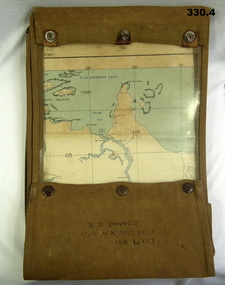
Map - MAP CASE & MAPS, Hec Robinson, C.1939-45
... Aircraft detachment. Maps WWII World War Two Second World War Map Cases Darwin Northern Territory Pine Creek Papua New Guinea Navigation Pouches zippered section marked "J. ...John James Davies No VX35280 enlisted in the 2nd AIF on 1.8.40 age 31 years. At discharge on 30.11.45 he held the rank of WO 2nd class in 2/108th Aust Light Anti Aircraft detachment..1) Map case, canvas khaki. .2) Map of Darwin, NT. Scale 4 miles to 1 inch. .3) Map, folded, New Guinea made by Hec Robinson Sydney .4) Map Pine Creek N.T.zippered section marked "J. J. Davies VX35280 108 LAD”maps, wwii, world war two, second world war, map cases, darwin, northern territory, pine creek, papua new guinea, navigation, pouches -
Frankston RSL Sub Branch
Calculator, Course & Speed, E.R Watts & Son London Pty Ltd
... navigation...calculator...ww2...raf...aircraft...Course and Speed calculator used as a navigational aid by Air Force pilots to calculate aircraft relative groundspeed whilst allowing for wind speed and direction. ...Frankston RSL Sub Branch 183 Cranbourne Road Frankston mornington-peninsula raaf navigation calculator ww2 raf aircraft course speed wind drift Inscribed "COURSE & SPEED CALCULATOR MKII", "E.R.WATTS & Son No 757/35", "A.M. ...Course and Speed calculator used as a navigational aid by Air Force pilots to calculate aircraft relative groundspeed whilst allowing for wind speed and direction. A similar example (MKIIA version) can be seen at the following Imperial War Museum web page: Inscribed "COURSE & SPEED CALCULATOR MKII", "E.R.WATTS & Son No 757/35", "A.M. REF No 6B/119".raaf, navigation, calculator, ww2, raf, aircraft, course, speed, wind drift -
Frankston RSL Sub Branch
Computer, Navigation
... This device was used as a navigational aid by aircraft pilots and crew. W&G Aerial Dead Reckoning Computer R.A.A.F. ...This device was used as a navigational aid by aircraft pilots and crew. W&G Aerial Dead Reckoning Computer R.A.A.F. ...Aerial Dead Reckoning Computer in leather pouch. This device was used as a navigational aid by aircraft pilots and crew. W&G Aerial Dead Reckoning Computer R.A.A.F. Mk 1 Made in Australia by White & Gillespie Front Scale: Distance Naut Miles, True Air Speed (Time Min, Hrs, Density Altitude, Air Temp ) Back Scale: Wind Correction Angle( True Heading ) The leather pouch has the following printed on the outside "W&G Aerial Dead Reckoning Computer R.A.A.F. Mk 1" -
 Frankston RSL Sub Branch
Sextant, Bubble
... navigation instrument used by the RAF and RAAF during the World War 2 era. A sextant is used to measure the altitude of celestial bodies above a horizontal line of reference. A navigator can use the horizon as this line of reference, but when an aircraft...navigation instrument used by the RAF and RAAF during the World War 2 era. A sextant is used to measure the altitude of celestial bodies above a horizontal line of reference. A navigator can use the horizon as this line of reference, but when an aircraft ...Bubble Sextant model Mark 1XA type A.M. 6B/218 in protective storage box. Complete, with operation instructions. This is an aviation navigation instrument used by the RAF and RAAF during the World War 2 era. A sextant is used to measure the altitude of celestial bodies above a horizontal line of reference. A navigator can use the horizon as this line of reference, but when an aircraft is above the clouds or flying at night, the navigator can’t see the horizon. The bubble sextant solves this problem by providing an artificial horizon.The storage case has a label with the following: "A.M. 6B/218 MK IX A" and the number "10772/42 (V)" -
Frankston RSL Sub Branch
Compass, Astro
... navigational tool used to determine true north from the position of the sun or astronomical bodies. These are used in circumstances where magnetic compasses and gyrocompasses are unreliable, for example in the presence of magnetic field anomalies (such as polar regions, ships hulls, aircraft hulls, etc.). ...navigational tool used to determine true north from the position of the sun or astronomical bodies. These are used in circumstances where magnetic compasses and gyrocompasses are unreliable, for example in the presence of magnetic field anomalies (such as polar regions, ships hulls, aircraft hulls, etc.). ...A World War 2 era W. W. Boes and Co. MKll astro compass typically used as an aviation navigation aid. It is manufactured from aluminum with black enamel finish. An astro compass is a navigational tool used to determine true north from the position of the sun or astronomical bodies. These are used in circumstances where magnetic compasses and gyrocompasses are unreliable, for example in the presence of magnetic field anomalies (such as polar regions, ships hulls, aircraft hulls, etc.). Nameplate on the base reads "ASTRO-COMPASS MK II / The W.W. BOES CO. / DAYTON, OHIO, USA"compass, astro compass, navigation, aeronautical, raaf, raf, ww2, -
 Waverley RSL Sub Branch
RAAF Navigation Computer
... Waverley RSL Sub Branch 161 Coleman Parade Glen Waverley melbourne Used by RAF and RAAF during WWII Believed to have been used in the battle of britain ican computer battle of britian computer aircraft computer mechanical computer Navigational Computer ICAN Metal faced bakelite box with rotating dial on front and a paper graph sheet enclosed in front cover a pencil for plotting course and position is attached to the side of the unit RAAF Navigation Computer ...Used by RAF and RAAF during WWII Believed to have been used in the battle of britainMetal faced bakelite box with rotating dial on front and a paper graph sheet enclosed in front cover a pencil for plotting course and position is attached to the side of the unitNavigational Computer ICANican computer, battle of britian computer, aircraft computer, mechanical computer