Showing 20 items matching "alexandra crescent"
-
 Surrey Hills Historical Society Collection
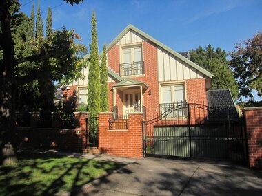
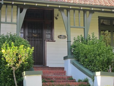
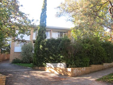
Photograph - 3 Alexandra Crescent, Surrey Hills, The Street Where You Live Project
... 3 Alexandra Crescent, Surrey Hills...The Street Where You Live Project Photograph 3 Alexandra Crescent, Surrey Hills ...Photos documenting this address as part of a photographic series undertaken by volunteer photographers during 2013 and 2014 for The Street Where You Live Project. This was organised through the Surrey Hills Neighbourhood Centre and covered the postcode 3127 in the cities of Boroondara and Whitehorse.These photos provide a snapshot of real estate in the suburbs of Mont Albert and Surrey Hills during a period of rapid change with many properties on large blocks demolished to create higher density residential development or renewal of single dwellings. At particular risk were properties not covered by heritage overlays, especially interwar housing and post 1950's housing. -
 Surrey Hills Historical Society Collection
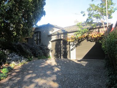
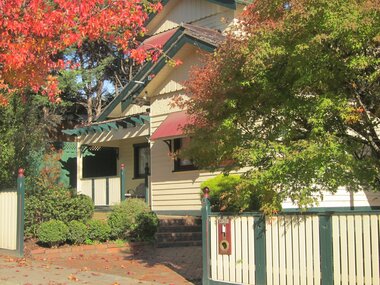
Photograph - 5 Alexandra Crescent, Surrey Hills, The Street Where You Live Project
... 5 Alexandra Crescent, Surrey Hills...The Street Where You Live Project Photograph 5 Alexandra Crescent, Surrey Hills ...Photos documenting this address as part of a photographic series undertaken by volunteer photographers during 2013 and 2014 for The Street Where You Live Project. This was organised through the Surrey Hills Neighbourhood Centre and covered the postcode 3127 in the cities of Boroondara and Whitehorse.These photos provide a snapshot of real estate in the suburbs of Mont Albert and Surrey Hills during a period of rapid change with many properties on large blocks demolished to create higher density residential development or renewal of single dwellings. At particular risk were properties not covered by heritage overlays, especially interwar housing and post 1950's housing. -
 Surrey Hills Historical Society Collection
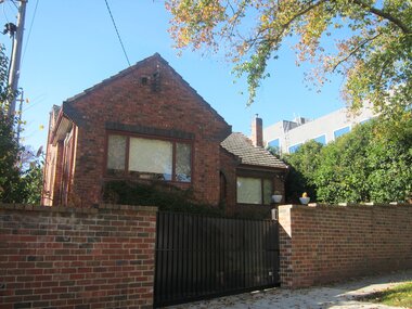
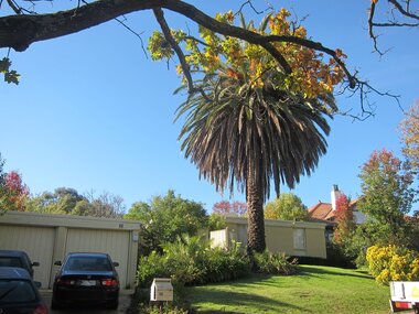
Photograph - 6 Alexandra Crescent, Surrey Hills, The Street Where You Live Project
... 6 Alexandra Crescent, Surrey Hills...The Street Where You Live Project Photograph 6 Alexandra Crescent, Surrey Hills ...Photos documenting this address as part of a photographic series undertaken by volunteer photographers during 2013 and 2014 for The Street Where You Live Project. This was organised through the Surrey Hills Neighbourhood Centre and covered the postcode 3127 in the cities of Boroondara and Whitehorse.These photos provide a snapshot of real estate in the suburbs of Mont Albert and Surrey Hills during a period of rapid change with many properties on large blocks demolished to create higher density residential development or renewal of single dwellings. At particular risk were properties not covered by heritage overlays, especially interwar housing and post 1950's housing. -
 Surrey Hills Historical Society Collection
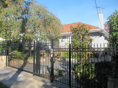
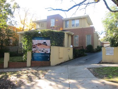
Photograph - 7 Alexandra Crescent, Surrey Hills, The Street Where You Live Project
... 7 Alexandra Crescent, Surrey Hills...The Street Where You Live Project Photograph 7 Alexandra Crescent, Surrey Hills ...Photos documenting this address as part of a photographic series undertaken by volunteer photographers during 2013 and 2014 for The Street Where You Live Project. This was organised through the Surrey Hills Neighbourhood Centre and covered the postcode 3127 in the cities of Boroondara and Whitehorse.These photos provide a snapshot of real estate in the suburbs of Mont Albert and Surrey Hills during a period of rapid change with many properties on large blocks demolished to create higher density residential development or renewal of single dwellings. At particular risk were properties not covered by heritage overlays, especially interwar housing and post 1950's housing. -
 Surrey Hills Historical Society Collection
Photograph - 8 Alexandra Crescent, Surrey Hills, The Street Where You Live Project
... 8 Alexandra Crescent, Surrey Hills...The Street Where You Live Project Photograph 8 Alexandra Crescent, Surrey Hills ...Photos documenting this address as part of a photographic series undertaken by volunteer photographers during 2013 and 2014 for The Street Where You Live Project. This was organised through the Surrey Hills Neighbourhood Centre and covered the postcode 3127 in the cities of Boroondara and Whitehorse.These photos provide a snapshot of real estate in the suburbs of Mont Albert and Surrey Hills during a period of rapid change with many properties on large blocks demolished to create higher density residential development or renewal of single dwellings. At particular risk were properties not covered by heritage overlays, especially interwar housing and post 1950's housing. -
 Surrey Hills Historical Society Collection
Photograph - 9 Alexandra Crescent, Surrey Hills, The Street Where You Live Project
... 9 Alexandra Crescent, Surrey Hills...The Street Where You Live Project Photograph 9 Alexandra Crescent, Surrey Hills ...Photos documenting this address as part of a photographic series undertaken by volunteer photographers during 2013 and 2014 for The Street Where You Live Project. This was organised through the Surrey Hills Neighbourhood Centre and covered the postcode 3127 in the cities of Boroondara and Whitehorse.These photos provide a snapshot of real estate in the suburbs of Mont Albert and Surrey Hills during a period of rapid change with many properties on large blocks demolished to create higher density residential development or renewal of single dwellings. At particular risk were properties not covered by heritage overlays, especially interwar housing and post 1950's housing. -
 Surrey Hills Historical Society Collection
Photograph - 10 Alexandra Crescent, Surrey Hills, The Street Where You Live Project
... 10 Alexandra Crescent, Surrey Hills...The Street Where You Live Project Photograph 10 Alexandra Crescent, Surrey Hills ...Photos documenting this address as part of a photographic series undertaken by volunteer photographers during 2013 and 2014 for The Street Where You Live Project. This was organised through the Surrey Hills Neighbourhood Centre and covered the postcode 3127 in the cities of Boroondara and Whitehorse.These photos provide a snapshot of real estate in the suburbs of Mont Albert and Surrey Hills during a period of rapid change with many properties on large blocks demolished to create higher density residential development or renewal of single dwellings. At particular risk were properties not covered by heritage overlays, especially interwar housing and post 1950's housing. -
 Surrey Hills Historical Society Collection
Photograph - 12 Alexandra Crescent, Surrey Hills, The Street Where You Live Project
... 12 Alexandra Crescent, Surrey Hills...The Street Where You Live Project Photograph 12 Alexandra Crescent, Surrey Hills ...Photos documenting this address as part of a photographic series undertaken by volunteer photographers during 2013 and 2014 for The Street Where You Live Project. This was organised through the Surrey Hills Neighbourhood Centre and covered the postcode 3127 in the cities of Boroondara and Whitehorse.These photos provide a snapshot of real estate in the suburbs of Mont Albert and Surrey Hills during a period of rapid change with many properties on large blocks demolished to create higher density residential development or renewal of single dwellings. At particular risk were properties not covered by heritage overlays, especially interwar housing and post 1950's housing. -
 Surrey Hills Historical Society Collection
Photograph - 18 Alexandra Crescent, Surrey Hills, The Street Where You Live Project
... 18 Alexandra Crescent, Surrey Hills...The Street Where You Live Project Photograph 18 Alexandra Crescent, Surrey Hills ...Photos documenting this address as part of a photographic series undertaken by volunteer photographers during 2013 and 2014 for The Street Where You Live Project. This was organised through the Surrey Hills Neighbourhood Centre and covered the postcode 3127 in the cities of Boroondara and Whitehorse.These photos provide a snapshot of real estate in the suburbs of Mont Albert and Surrey Hills during a period of rapid change with many properties on large blocks demolished to create higher density residential development or renewal of single dwellings. At particular risk were properties not covered by heritage overlays, especially interwar housing and post 1950's housing. -
 Surrey Hills Historical Society Collection
Folder of real estate advertisements, Folders of real estate advertisements (Streets beginning with A), Various
... ...alexandra crescent...Surrey Hills Historical Society Collection 190A Canterbury Road Canterbury melbourne agnes street alandale street albany crescent albert street albion street alexandra crescent allie street amiens street anderson street arthur street arundel crescent A4 folders with individual pockets for each property in streets beginning with A located in Surrey Hills and Mont Albert. ...A4 folders with individual pockets for each property in streets beginning with A located in Surrey Hills and Mont Albert. Folders are ordered by street name and then chronologically by property number. Each property has its own pocket. This may include multiple real estate advertisements collected from sales over time. It may also include copies of any research undertaken by Alan Holt and / or members of the SHNCHC team. These are augmented by cards in the Alan Holt index file and by his property registers of Surrey Hills and Mont Albert.agnes street, alandale street, albany crescent, albert street, albion street, alexandra crescent, allie street, amiens street, anderson street, arthur street, arundel crescent -
Glen Eira Historical Society
Document - National Trust Register
... Crescent... Hotham Street... Nagle Avenue... Inkerman Street... Iknerman Road... Sandham Street... Selwyn Street... St. Georges Road... Willow Street... Grange Road... Station Place... Railway Parade... Alexandra...Neerim Road Poplar Grove Avoca Grove Balaclava Road Orrong Road Bambra Road Glen Eira Road Hood Crescent Hawthorn Road Glenferri Street Glenhuntly Road Glen Huntly Road Kambrook Road Kooyong Road Lirrewa Grove Manor Grove North Road Pearson Avenue Seymour Road Alma Road Craddock Avenue Dandenong Road Lyndoch Avenue Orrong Crescent Hotham Street Nagle Avenue Inkerman Street Iknerman Road Sandham Street Selwyn Street St. Georges Road Willow Street Grange Road Station Place Railway Parade Alexandra Street Wood Crescent Elizabeth Street Halstead Street Mavho Street Tucker Road McKinnon Road Nepean Highway Wheatly Road Uniting Church Carnegie Athole St Stephen's Uniting Church Caulfield St Aloysius' Catholic Church Halstead St Mary's Anglican Church Caulfield Caulfield Town Hall Anseln The Glen Woolamai Caulfield House Caulfield Hospital Lirrewa Labassa Fairfield Hall Bellecourt Bagatelle Myoora Rosecraddock Adam and Eve - Karl Duldig The Family - Karl Duldig Caulfield Primary School Septimus Miller Memorial Chapel Brighton Cemetery Hopetoun Gardens State Savings Bank Elsternwick Anderson Organ Hopetoun Private Hospital (Melrose) Rippon Lea Ripponlea Burreel O'Neill College Lisbon House Elsternwick Club Merkin-Schutze Organ Presentation Convent Duldig Mural - Kadimah Cultural Centre Glenmoore Craigellachie St James the Great Glenfern Grimwade House Dacre Trinity Congregational Uniting Church Glenhuntly Alnwick Holmwood New Alexandra Joscelyne Organ Smith Organ Fincham Organ St George's Bentleigh McKinnon Progress Hall Wurlitzer Organ Moorabbin Town Hall Christ Anglican Church St Mary's Jubilee School St Stephen's Presbyterian Church Elsternwick Congregational Church St Mary's Church of England Former Metropolitan Fire Brigade Station No. 31 St Mary's Jubilee Church Belle Court Trinity Congregational Church Heatherbrae Carnegie Caulfield Caulfield North Caulfield South Elsternwick Glen Huntly Glenhuntly Murrumbeena St Kilda East Bentleigh McKinnon Moorabbin Ormond National Trust of Australia National Trust Register Houses Churches Schools Organs Vallati Gladys Mansions Document National Trust Register ...This file contains two items relating to historic buildings in Glen Eira listed on the National Trust Registry: 1/A fax, sent to Gladys Vallati on 02/03/1995 from the National Trust of Australia listing buildings on the Trust’s registry in the Glen Eira area, as well as their addresses and status on the register (5 pages). (Additional photocopy taken for preservation purposes). 2/A typed list of buildings in the Glen Eira area (mainly Caulfield) which are on the National Trust list, including address, approximate date of construction and status on the register. Date of production of the list is unknown. (6 pages).neerim road, poplar grove, avoca grove, balaclava road, orrong road, bambra road, glen eira road, hood crescent, hawthorn road, glenferri street, glenhuntly road, glen huntly road, kambrook road, kooyong road, lirrewa grove, manor grove, north road, pearson avenue, seymour road, alma road, craddock avenue, dandenong road, lyndoch avenue, orrong crescent, hotham street, nagle avenue, inkerman street, iknerman road, sandham street, selwyn street, st. georges road, willow street, grange road, station place, railway parade, alexandra street, wood crescent, elizabeth street, halstead street, mavho street, tucker road, mckinnon road, nepean highway, wheatly road, uniting church carnegie, athole, st stephen's uniting church caulfield, st aloysius' catholic church, halstead, st mary's anglican church caulfield, caulfield town hall, anseln, the glen, woolamai, caulfield house, caulfield hospital, lirrewa, labassa, fairfield hall, bellecourt, bagatelle, myoora, rosecraddock, adam and eve - karl duldig, the family - karl duldig, caulfield primary school, septimus miller memorial chapel, brighton cemetery, hopetoun gardens, state savings bank elsternwick, anderson organ, hopetoun private hospital (melrose), rippon lea, ripponlea, burreel, o'neill college, lisbon house, elsternwick club, merkin-schutze organ, presentation convent, duldig mural - kadimah cultural centre, glenmoore, craigellachie, st james the great, glenfern, grimwade house, dacre, trinity congregational uniting church glenhuntly, alnwick, holmwood, new alexandra, joscelyne organ, smith organ, fincham organ, st george's bentleigh, mckinnon progress hall, wurlitzer organ, moorabbin town hall, christ anglican church, st mary's jubilee school, st stephen's presbyterian church, elsternwick congregational church, st mary's church of england, former metropolitan fire brigade station no. 31, st mary's jubilee church, belle court, trinity congregational church, heatherbrae, carnegie, caulfield, caulfield north, caulfield south, elsternwick, glen huntly, glenhuntly, murrumbeena, st kilda east, bentleigh, mckinnon, moorabbin, ormond, national trust of australia, national trust register, houses, churches, schools, organs, vallati gladys, mansions -
 Surrey Hills Historical Society Collection
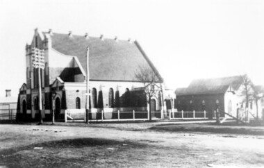
Photograph, Surrey Hills Methodist Church in 1918, 1918
... The original Methodist (Wesleyan) Church was built on the corner of Alexandra Crescent and Windsor Lane in 1888. It was enlarged in 1892. ...Surrey Hills Historical Society Collection 190A Canterbury Road Canterbury melbourne The original Methodist (Wesleyan) Church was built on the corner of Alexandra Crescent and Windsor Lane in 1888. It was enlarged in 1892. ...The original Methodist (Wesleyan) Church was built on the corner of Alexandra Crescent and Windsor Lane in 1888. It was enlarged in 1892. In 1908 this building was removed to Valonia Avenue by horse-drawn dray. The brick church was built in 1915 after which the earlier building became the Sunday School. In 1977 the Methodist Church joined with others to become the Uniting Church. In more recent times, the brick church has been painted but architectural details visible in this photo can still be discerned.Black and white photo of a brick and rendered building taken from diagonally opposite across Canterbury Road looking to the north-west. The church sits behind a woven-wire fence with an opening at the front and at the side to a portico off Valonia Street. On the RHS is the church hall and on the LHS a small part of the adjacent house can be seen.surrey hills methodist (wesleyan) church, surrey hills uniting church -
Marysville & District Historical Society
THE TRIANGLE NEWS-VOL 36 NO 4-FEBRUARY 6 2009
... crescent...environmental forum...disclaimer...fire calls...indidj art gallery...australian & aboriginal art...church notices...mops...women of hope...bible quote...men's fellowship breakfast...life centre alexandra...Marysville & District Historical Society 39 Darwin Street Marysville yarra-valley-and-the-dandenong-ranges marysville victoria australia dr lachlan fraser running australian ultramarathon runners assocn deadline advertising rates diary dates snippets from history gallipoli park joe white alex white kerami guest house wandsworth kerami crescent environmental forum disclaimer fire calls indidj art gallery australian & aboriginal art church notices mops women of hope bible quote men's fellowship breakfast life centre alexandra falls family fellowship mount cathedral baptist church buxton 10th anniversary founding fellowship ivor & yvonne jones buxton memorial hall buxton weather graphs marysville fire brigade children's services team trash & treasure stall holders wirreanda festival mystic mountains tourism marysville golfers alexandra cinema narby day narbethong hall bushdance & dinner outreach services murrindindi shire brewers choice home brew david kitchen gluten free beer community health services maryor's chair energy efficient homes councillor comment health & wellbeing new shire officer environment strategy yarra valley grape grazing country touch t.a.c. road safety planning permit notice of application payment of rates & charges marysville real estate marysville medical clinic THE TRIANGLE NEWS-VOL 36 NO 4-FEBRUARY 6 2009 ...marysville, victoria, australia, dr lachlan fraser, running, australian ultramarathon runners assocn, deadline, advertising rates, diary dates, snippets from history, gallipoli park, joe white, alex white, kerami guest house, wandsworth, kerami crescent, environmental forum, disclaimer, fire calls, indidj art gallery, australian & aboriginal art, church notices, mops, women of hope, bible quote, men's fellowship breakfast, life centre alexandra, falls family fellowship, mount cathedral baptist church buxton, 10th anniversary founding fellowship, ivor & yvonne jones, buxton memorial hall, buxton weather graphs, marysville fire brigade, children's services team, trash & treasure stall holders, wirreanda festival, mystic mountains tourism, marysville golfers, alexandra cinema, narby day, narbethong hall, bushdance & dinner, outreach services, murrindindi shire, brewers choice home brew, david kitchen, gluten free beer, community health services, maryor's chair, energy efficient homes, councillor comment, health & wellbeing, new shire officer, environment strategy, yarra valley grape grazing, country touch, t.a.c. road safety, planning permit notice of application, payment of rates & charges, marysville real estate, marysville medical clinic -
 Ringwood and District Historical Society
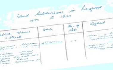
Document - Research Notes, Richard Carter, Land Subdivisions in Ringwood 1890-1950
... (1923) Mullum Road, The Centreway, Wattle Crescent (now Wattle Avenue) Reserve Crescent (now Reserve Road) Pg15 DUBLIN ROAD ESTATE LP11993 (1923) Alexandra Road, Vonadawn Avenue, Green Street, Wood Street, Howard Avenue, Bedford Road, Dublin Road Pg16 CARLINGA ESTATE RINGWOOD LP9620 (1923) Bourke Street, Bond Street, Ringwood Street Pg17 PRATT'S JUNCTION ESTATE (LP?) ...(1923) Mullum Road, The Centreway, Wattle Crescent (now Wattle Avenue) Reserve Crescent (now Reserve Road) Pg15 DUBLIN ROAD ESTATE LP11993 (1923) Alexandra Road, Vonadawn Avenue, Green Street, Wood Street, Howard Avenue, Bedford Road, Dublin Road Pg16 CARLINGA ESTATE RINGWOOD LP9620 (1923) Bourke Street, Bond Street, Ringwood Street Pg17 PRATT'S JUNCTION ESTATE (LP?) ...Handwritten table listing main local pre-1950s subdivisions in the Ringwood area, with estate names, streets, number of allotments for sale, and where known, vendor agent, LP (Lodged Plan) title registration number, and auction/sale date, some with sale price.Pg1 RINGWOOD STATION ESTATE LP3070 (Year?) Station Street, William Street (now Kendall Street), Wantirna Road, Station Street Pg1 RINGWOOD TOWNSHIP ESTATE LP5577 (1913) Station Road (now Warrandyte Road), Pratt Street (part now Aird Street), Whitehorse Road Pg2 RINGWOOD ORCHARD ESTATE LP4315 (1914) Brysons Road, Hillcrest Road, Anzac Avenue, Sulva Road Pg3 RINGWOOD RAILWAY ESTATE LP7522 (1918) Whitehorse Road (now Mount Dandenong Road), Dublin Road, Freeman Street, Patterson Street, Bona Street Pg4 THE RINGWOOD ESTATE LP7578 (1919) Warrandyte Road, Hobart Street, Paxton Street, Arnold Street Pg5 GARDEN FARMS ESTATE (LP?) (1919) Canterbury Road, Armstrong Road, Bungalook Road, Orchard Road, Bayswater Road (now Mountain Highway) Pg6 THE RINGWOOD ESTATE (SECOND SUB-DIVISION) LP7604 (1919) Warrandyte Road, Tamar Street, Derwent Street, Mersey Street Pg7 RINGWOOD STATION ESTATE LP7703 (1919) Bedford Road, Williams Grove (now Lena Grove) Pg8 RINGWOOD TOWNSHIP ESTATE LP8198 (1919) Wantirna Road, Ellison Street, Haig Street, Greenwood Avenue Pg9 EASTFIELD ESTATE (LP?) (1920) Eastfield Road, Longview Road, Pleasant Rise, The Mount Pg10 ELECTRIC RAILWAY ESTATE RINGWOOD LP9473 (1922) Campbell Street, Myrtle Avenue, George Street (now Tudor Court), Henry Street (now Myrtle Avenue), Williams Grove (now Lena Grove) Pg11 RINGWOOD PARK ESTATE LP7884 (1922 - two stages) Wonga Road (now Loughnan Road), William Street, Andrew Street, Harrison Street Pg12 HEATHMONT STATION ESTATE LP11009 (Date? - after 1922) Lisgoold Street, Viviani Crescent, Balrour Avenue, Station Street (now part Heathmont Road and part Wainui Street) Pg13 RINGWOOD RAILWAY ESTATE LP10507 (1923) Whitehorse Road, Sherbrooke Avenue, Burwood Avenue, Bonview Avenue, Heatherbrae Avenue, Grant Crescent Pg14 GARDEN HOMES ESTATE (LP?) (1923) Mullum Road, The Centreway, Wattle Crescent (now Wattle Avenue) Reserve Crescent (now Reserve Road) Pg15 DUBLIN ROAD ESTATE LP11993 (1923) Alexandra Road, Vonadawn Avenue, Green Street, Wood Street, Howard Avenue, Bedford Road, Dublin Road Pg16 CARLINGA ESTATE RINGWOOD LP9620 (1923) Bourke Street, Bond Street, Ringwood Street Pg17 PRATT'S JUNCTION ESTATE (LP?) (1923) Junction Street, Georges Road, Oliver Street, Whitehorse Road Pg18 EAST RINGWOOD ESTATE LP10492 (1923) Bona Street, Patterson Street, Miller Grove, Fairview Avenue, Eastfield Road, Whitehorse Road (now Mount Dandenong Road) Pg19 COLEMAN'S HEATHMONT ESTATE LP9974 (1923) Canterbury Road, Bedford Road, Alvena Crescent, Coleman Street, Leonard Street (now Royal Avenue) Pg20 RINGWOOD HEIGHTS ESTATE LP10506 (1924) Whitehorse Road, Bonview Avenue, Grant Crescent, Hillcrest Avenue, Heatherbrae Avenue, Margaret Street, Mary Street Pg21 EAST RINGWOOD STATION ESTATE LP10551 (1924) Knaith Road, Wenwood Street, Lois Street, Victoria Street, Station Street (now Railway Avenue) Pg22 GRAND VIEW ESTATE LP11019 (1924) Whitehorse Road, Rupert Street, Herbert Street, Leonard Street Pg23 RINGWOOD RAILWAY ESTATE & RINGWOOD HEIGHTS ESTATE - FINAL SECTIONS LP10506 & LP10507 (1924) Whitehorse Road, Sherbrooke Avenue, Burwood Avenue, Bonview Avenue, Heatherbrae Avenue, Margaret Street, Mary Street, Grant Crescent Pg24 RINGWOOD EAST ELECTRIC STATION ESTATE (LP?) (1924) Railway Parade (now Patterrson Street), Federal Road, Howship Avenue (part now French Street), Dublin Road, Rosedale Crescent Pg25 BEDFORD PARK (now Ringwood Secondary College) (LP?) (1924) Bedford Road, Adams Street, Anderson Street, Joyce Street, Graham Road Pg26 CROWN JEWEL ESTATE LP11645 (Private sales after 1924) Mount Dandenong Road, Mirabel Avenue, Valda Avenue, Evon Avenue, Velma Grove Pg27 GRAND CENTRAL ESTATE LP10917 (1925) Heathmont Road, Great Ryrie Street, Douglas Street, Garden Street, Bellevue Avenue Pg28 RINGWOOD (unnamed estate - 1926) Nelson Street, Seymour Street, Whitehorse Road Pg29 EAST RINGWOOD RAILWAY STATION ESTATE (YEAR? - 25 shops 60 villas) Railway Avenue, Dublin Road, Lawrence Grove, Stanley Avenue, Knaith Road Pg30 CHARM VIEW ESTATE (LP?) (year? - after 1926) Canterbury Road, Heathmont Road, Dickasons Road, Bennjett Avenue, Orchid Street Pg31 SUNBEAM ESTATE LP12150 (Circa 1925) Govt Road (now Old Lilydale Road), Sunbeam Avenue, Holland Road, Everard Street (now Everard Road) Pg32 FAIRVIEW ESTATE EAST RINGWOOD LP10853 (Circa 1924) Eastfield Road, Patterson Street, Margaret Street (now Short Street) Pg33 EAST RINGWOOD TOWNSHIP ESTATE LP3025 (Circa 1924 - 35 allotments) Mount Dandenong Road, Grey Street, Eastfield Road Pg34 EAST RINGWOOD TOWNSHIP ESTATE LP3025 (Circa 1924 - 49 allotments) and STATE SCHOOL ESTATE (26 allotments) and EAST RINGWOOD STATION ESTATE (14 shop sites) Mount Dandenong Road, Grety Street, Dunn Street, Eastfield Road, King Street, Holland Road, Dublin Road, Patterson Street, Bona Street Pg35 EAST RINGWOOD CENTRAL ESTATE LP17004 (1948) Knaith Road, Shasta Avenue, Talofa Avenue, Russet Road, Dublin Road Pg36 WARE ESTATE LP43360 (1958) Ware Crescent, Davey Drive, Grey Road (now Grey Street), Mount Dandenong Road Pg37 Lot 57 Kendall Street LP3070 (1939) £75.0.0 Pg37 Lot 14 LP7346 (year?) £225 Pg37 Lot 8 WHITE HORSE ESTATE LP14010 (year?) Maroondah Hwy, Seymour Street £98.9.0 Pg37 Lots 4-14 incl. LP10902 (year?) £300 Pg37 Lots 69&70 LP2216 (1939) Bedford Road, Pitt Street £500 Pg37 Lots 60&70 LP2216 (year?) £460 Pg37 MOUNTAIN VIEW ESTATE LP10902 (1936) Lots 1&2, 19-22 Wantirna Road, Daisy Street £50 Pg38 RAILWAY STATION ESTATE RINGWOOD EAST LP7522 (1925) Lots 16 to 19 £250 Pg38 RINGWOOD PARK ESTATE (LP?) (1924) Lot 112 Munro Street £230 Pg38 RINGWOOD TOWNSHIP ESTATE (LP?) (1925) Lot 57 Wantirna Road £850 Pg38 ELECTRIC RAILWAY ESTATE LP9473 (1925) Lot 98 & 99 £180 (30/- foot) Pg38 ELECTRIC RAILWAY ESTATE LP9473 (year?) Lot 100 £233.12.6 incl improvements (£2.12.6 foot) Pg38 Lot 22&23 Bedford Road Heathmont (LP & year?) £675 incl improvements Pg39 Lot 9 Mullum Mullum Road LP8221 (1923) £150 Pg39 Lot 27 Haig Street LP8198 (1925) £825 Pg39 Lot 56 Haig Street cnr Wantirna Road LP8198 (1923) £171 Pg39 Lots 3 & 4 Loughnan Road LP9626 (192?) £147 Pg39 Lots 98 & 99 Myrtle Avenue LP9473 (1925) £180 Pg39 Lots 80 & 81 Myrtle Avenue LP9473 (1929) £150 Pg39 Lot 30 Sherbrooke Avenue LP10507 (1926) £700 incl improvements Pg40 Lot 10 (year?) LP7703 £750 Pg40 Lot 36 (year?) LP7522 £25 Pg40 Lot 38 Pitt Street LP2216 (year?) £350 Pg40 Lot 7 Dublin Road cnr Green Street LP11993 (year?) £300 -
 Royal Australian and New Zealand College of Obstetricians & Gynaecologists (RANZCOG)
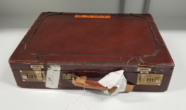
Equipment - Medical case used by Dr Noel Clarkson Holmes, c. 1960s
... Crescent Naarm (Melbourne) melbourne When acquired, this case held numerous pieces of surgical laparoscopy equipment. The equipment inside the case was used by Dr Noel Clarkson Holmes sometime between 1964-1967, when he was training under Dr Sidney Page at the Princess Alexandra Hospital in Brisbane. ...When acquired, this case held numerous pieces of surgical laparoscopy equipment. The equipment inside the case was used by Dr Noel Clarkson Holmes sometime between 1964-1967, when he was training under Dr Sidney Page at the Princess Alexandra Hospital in Brisbane. This case was purchased at the same time to carry this equipment, and has been repaired several times by Dr Clarkson Holmes.Brown leather briefcase. Briefcase is fastened by combination lock latches at the front. Inside of the case is lined with yellow felt. There are three accordion style storage pockets with leather trim inside the lid of the briefcase. A strip of orange tape has been attached to the outer top of the case, which carries the handwriting 'DR. N. HOLMES'. A similar strip of white tape is also attached to one side of the briefcase, which carries the handwriting 'Dr. N Holmes' -
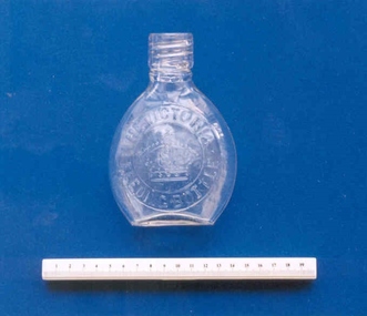 Royal Australian and New Zealand College of Obstetricians & Gynaecologists (RANZCOG)
Infant feeding bottle, 'The Victoria Feeding Bottle', 1900 (approximate)
... Royal Australian and New Zealand College of Obstetricians & Gynaecologists (RANZCOG) 1 Bowen Crescent Naarm (Melbourne) melbourne This design was modelled on Queen Victoria's nursery bottles and would have been in use during mid 1880s to the early 1900s. This item is very similar to the Alexandra ...This design was modelled on Queen Victoria's nursery bottles and would have been in use during mid 1880s to the early 1900s. This item is very similar to the Alexandra Feeding Bottle featured in the Maws catalogue of 1868. It was named after the then Princess Alexandra of Wales, later Queen Alexandra. This model had a glass stopper and a long rubber tube which connected at one end to a teat and to a glass tube at the other. The fittings were very difficult to clean and would hold milk particles, making them a breeding ground for the formation of bacteria. Sterilisation of feeding bottles by boiling, and boiling of milk and water, were not practiced effectively at this time.Globular shaped feeding bottle embossed with a crown on the upper surface. Next of bottle fitted with a glass thread. Writing imprinted on front of bottle, inside a ring, reads "THE VICTORIA FEEDING BOTTLE". The bottle has a flat shaped bottom to allow it to balance on a surface while being used."THE VICTORIA FEEDING BOTTLE"infant feeding, infant care -
 Sunshine and District Historical Society Incorporated
Photograph - Sunshine Photographs 2022 Part 1, John Alchin, 2022
... Alexandra Avenue...Sunshine...Sunshine Presbyterian Church...Anderson Road...Andy's Service Station...Service Station...Sunshine Presbyterian Church Manse...Hot Springs Spa...StoreLocal...Ten Pin Bowling Centre...Ballarat Road Service Road...Stony Creek...Stony Creek Drain...Sun Crescent...Sunshine Municipal Offices Alexandra Avenue Sunshine Sunshine Presbyterian Church Anderson Road Andy's Service Station Service Station Sunshine Presbyterian Church Manse Hot Springs Spa StoreLocal Ten Pin Bowling Centre Ballarat Road Service Road Stony Creek Stony Creek Drain Sun Crescent City Place Reflexio Qualis Clarke Street Derby Road Bridge Derby Road Devonshire Road Dickson Street Durham Road Glengala Road Bridge Fraser Street Legenda's Garden H.V. ...These photographs provide a visual record of assorted buildings, street views, and notable locations throughout Sunshine in 2022.This collection of photographs preserves a visual record of Sunshine 2022.5627.01 - Alexandra Ave Sunshine - Sunshine Muncipal Offices 2022 Photo 01.JPG 5627.02 - Alexandra Ave Sunshine - Sunshine Muncipal Offices 2022 Photo 02.JPG 5627.03 - Alexandra Ave Sunshine - Sunshine Muncipal Offices 2022 Photo 05.JPG 5627.04 - Anderson Rd - Sunshine Vietnamese Baptist Church.JPG 5627.05 - Anderson Rd 79 - Andy's Service Station Sign 2022 Photo 02.JPG 5627.06 - Anderson Rd 79 Sunshine - Andy's Service Station Sign 2022 Photo 01.JPG 5627.07 - Anderson Rd 126 Sunshine - Sunhine Presbyterian Church Manse 2022 Photo 01.JPG 5627.08 - Andersons Rd 101 - 103 Sunshine 2022 Photo 01.JPG 5627.09 - Ballarat Rd 503 Sunshine - StoreLocal 2022 Photo 01.JPG 5627.10 - Ballarat Rd 505 Sunshine - Former AMF Ten Pin Bowling Centre 2022.JPG 5627.11 - Ballarat Rd 505 Sunshine - Melbourne Airport Rail Construction Support Facility Sign 2022 Photo 02.JPG 5627.12 - Ballarat Service Rd Sunshine - Stony Creek Culvert 2022 Photo 01.JPG 5627.13 - City Place 2 -4 Sunshine 2022 Photo 01.JPG 5627.14 - City Place 8 - 12 Sunshine 2022 Photo 01.JPG 5627.15 - City Place 22 Sunshine 2022 Photo 01.JPG 5627.16 - City Place 24 Sunshine 2022 Photo 01.JPG 5627.17 - City Place Sunshine - Reflexio Qualis 2022 Photo 02.JPG 5627.18 - Clarke St 6 Sunshine 2022 Photo 01.JPG 5627.19 - Derby Rd Sunshine - Kororoit Creek Bridge 2022 Photo 02.JPG 5627.20 - Derby St 105 Sunshine 2022 Photo 01.JPG 5627.21 - Devonshire Rd 5 Sunshine 2020 Photo 01.JPG 5627.22 - Dickson St 9 - 15 Sunshine 2022 Photo 01.JPG 5627.23 - Dickson St Sunshine - Reflexio Qualis 2022 Photo 02.JPG 5627.24 - Durham Rd 113 Sunshine 2022 Photo 01.JPG 5627.25 - Durham St 115 Sunshine - Former Bank 2022 Photo 01.JPG 5627.26 - Forrest St Railway Bridge Kororoit Creek 2022 Photo 01.JPG 5627.27 - Fraser St 75 Sunshine - Wilfred Clayton's House 2022 Photo 01.JPG 5627.28 - Fraser St Sunshine - Legenda's Garden 2022 Photo 01.JPG 5627.29 - Fraser St Sunshine - Legenda's Garden 2022 Photo 04.JPG 5627.30 - H.V. McKay Memorial Gardens 2022 Photo 02.JPG 5627.31 - H.V. McKay Memorial Gardens 2022 Photo 03.JPG 5627.32 - H.V. McKay Memorial Gardens 2022 Photo 04.JPG 5627.33 - H.V. McKay Pedestrian Bridge 2022 Photo 01.JPG 5627.34 - Hampshire Rd 36 Sunshine 2022 Photo 01.JPG 5627.35 - Hampshire Rd 42 Sunshine 2022 Photo 01.JPG 5627.36 - Hampshire Rd 44 Sunshine 2022 Photo 01.JPG 5627.37 - Hampshire Rd 68 - 70 Sunshine 2022 Photo 01.JPG 5627.38 - Hampshire Rd 74 - 76 Sunshine - Shops 2022 Photo 01.JPG 5627.39 - Hampshire Rd 74 - 76 Sunshine 2022 Photo 01.JPG 5627.40 - Hampshire Rd 74 - 76 Sunshine 2022 Photo 02.JPG 5627.41 - Hampshire Rd 74 - 76 Sunshine 2022 Photo 04.JPG 5627.42 - Hampshire Rd 86 - 88 Sunshine - Shops 2022 Photo 02.JPG sunshine municipal offices, alexandra avenue, sunshine, sunshine presbyterian church, anderson road, andy's service station, service station, sunshine presbyterian church manse, hot springs spa, storelocal, ten pin bowling centre, ballarat road service road, stony creek, stony creek drain, sun crescent, city place, reflexio qualis, clarke street, derby road bridge, derby road, devonshire road, dickson street, durham road, glengala road bridge, fraser street, legenda's garden, h.v. mckay memorial gardens, sunshine pedestrian bridge, hampshire road -
 Sunshine and District Historical Society Incorporated
Administrative record - City of Sunshine - Commissioner Mr Alexander Alex George Gillon Collection 1976 - 1982 - Notice of ordinary meeting of the council of the City of Sunshine to be held on 9th February 1977, City of Sunshine, 28th January 1977
... Proposed Closure of Roads & Railway Land Alexandra Avenue and Service Street Request of inquiry into the M&MBW operations Turkish disaster appeal request of financial assistance Proposed assignment of lease The Hub Lease of land Scout Hall Lowe Crescent Castley Hall Financial Statement Proposed Name Railway Station Deer Park Lot 272 Beela Court Nuisance conditions of truck parking Proposed purchase o Garbage Tip Proposed Liquor Licence Albion Rovers Soccer Club Proposed name part of St. ...City of Sunshine Alexander "Alex" George Gillon The Hub Sun Crescent Sunshine Lowe Crescent Castley Hall Simmie Street Deer Park Railway Station Deer Park Albion Rovers Soccer Club Selwyn Park Albion Laurel Street St. Albans Beela Court Sunshine West Proposed Closure of Roads & Railway Land Alexandra Avenue and Service Street Request of inquiry into the M&MBW operations Turkish disaster appeal request of financial assistance Proposed assignment of lease The Hub Lease of land Scout Hall Lowe Crescent Castley Hall Financial Statement Proposed Name Railway Station Deer Park Lot 272 Beela Court Nuisance conditions of truck parking Proposed purchase o Garbage Tip Proposed Liquor Licence Albion Rovers Soccer Club Proposed name part of St. ...Proposed Closure of Roads & Railway Land Alexandra Avenue and Service Street Request of inquiry into the M&MBW operations Turkish disaster appeal request of financial assistance Proposed assignment of lease The Hub Lease of land Scout Hall Lowe Crescent Castley Hall Financial Statement Proposed Name Railway Station Deer Park Lot 272 Beela Court Nuisance conditions of truck parking Proposed purchase o Garbage Tip Proposed Liquor Licence Albion Rovers Soccer Club Proposed name part of St. Albans City of Keilor Acquisition of Tip site from Albion Reid Pty Ltd Sale of land Laurel Street to Education Department Proposed Indoor Heated Swimming Pool Council Officers Reports city of sunshine, alexander "alex" george gillon, the hub, sun crescent, sunshine, lowe crescent, castley hall, simmie street, deer park railway station, deer park, albion rovers soccer club, selwyn park, albion, laurel street, st. albans, beela court, sunshine west -
 Sunshine and District Historical Society Incorporated
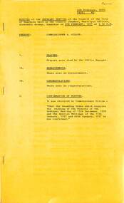
Administrative record - City of Sunshine - Commissioner Mr Alexander Alex George Gillon Collection 1976 - 1982 - Minutes of the ordinary meeting of council held on 9th February 1977, City of Sunshine, 9th February 1977
... Proposed Closure of Roads & Railway Land Alexandra Avenue and Service Street Request of inquiry into the M&MBW operations Turkish disaster appeal request of financial assistance Proposed assignment of lease The Hub Lease of land Scout Hall Lowe Crescent Castley Hall Financial Statement Proposed Name Railway Station Deer Park Lot 272 Beela Court Nuisance conditions of truck parking Proposed purchase o Garbage Tip Proposed Liquor Licence Albion Rovers Soccer Club Proposed name part of St. ...City of Sunshine Alexander "Alex" George Gillon The Hub Sun Crescent Sunshine Lowe Crescent Castley Hall Simmie Street Deer Park Railway Station Deer Park Albion Rovers Soccer Club Selwyn Park Albion Laurel Street St. Albans Beela Court Sunshine West Proposed Closure of Roads & Railway Land Alexandra Avenue and Service Street Request of inquiry into the M&MBW operations Turkish disaster appeal request of financial assistance Proposed assignment of lease The Hub Lease of land Scout Hall Lowe Crescent Castley Hall Financial Statement Proposed Name Railway Station Deer Park Lot 272 Beela Court Nuisance conditions of truck parking Proposed purchase o Garbage Tip Proposed Liquor Licence Albion Rovers Soccer Club Proposed name part of St. ...Proposed Closure of Roads & Railway Land Alexandra Avenue and Service Street Request of inquiry into the M&MBW operations Turkish disaster appeal request of financial assistance Proposed assignment of lease The Hub Lease of land Scout Hall Lowe Crescent Castley Hall Financial Statement Proposed Name Railway Station Deer Park Lot 272 Beela Court Nuisance conditions of truck parking Proposed purchase o Garbage Tip Proposed Liquor Licence Albion Rovers Soccer Club Proposed name part of St. Albans City of Keilor Acquisition of Tip site from Albion Reid Pty Ltd Sale of land Laurel Street to Education Department Proposed Indoor Heated Swimming Pool Council Officers Reports city of sunshine, alexander "alex" george gillon, the hub, sun crescent, sunshine, lowe crescent, castley hall, simmie street, deer park railway station, deer park, albion rovers soccer club, selwyn park, albion, laurel street, st. albans, beela court, sunshine west