Showing 200 items matching "alluvial"
-
 Tarnagulla History Archive
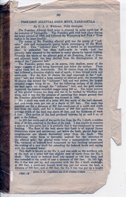
Pages from a book: Poseidon Alluvial Gold Mine, Tarnagulla, Poseidon Alluvial Gold Mine, Tarnagulla, circa 1916
... Poseidon Alluvial Gold Mine, Tarnagulla...Pages from a book (unknown), this excerpt titled 'Poseidon Alluvial Gold Mine, Tarnagulla' by O.A.L. Whitelaw, Field Geologist. ...Poseidon Alluvial Gold Mine, Tarnagulla Pages from a book: Poseidon Alluvial Gold Mine, Tarnagulla ...Murray Comrie Collection. Pages from a book (unknown), this excerpt titled 'Poseidon Alluvial Gold Mine, Tarnagulla' by O.A.L. Whitelaw, Field Geologist. Includes a map (also extracted from the book) with title 'Poseidon Alluvial Gold Mines'. Map of the mines entire workings, above and below ground. tarnagulla, poseidon, mine, mining, gold -
 Federation University Historical Collection
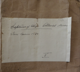
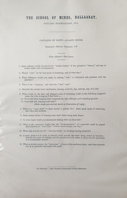
Document, The School of Mines, Ballarat January Examinations for Captains of Shift - Alluvial Mines, 1874, 01/1874
... The School of Mines, Ballarat January Examinations for Captains of Shift - Alluvial Mines, 1874...The School of Mines, Ballarat January Examinations for Captains of Shift - Alluvial Mines, 1874 Document Document John Ferres John Ferres ...A number of printed, foolscap examinations for the Ballarat School of Mines January Examinations in 1874 for Captain of Shift - Quartz Mines. ballarat school of mines, captains of shift, examination, alluvial mining -
 Federation University Historical Collection
Document, The School of Mines, Ballarat January Examinations for Captains of Shift - Alluvial Mines, 1874, 10/1873
... The School of Mines, Ballarat January Examinations for Captains of Shift - Alluvial Mines, 1874...The School of Mines, Ballarat January Examinations for Captains of Shift - Alluvial Mines, 1874 Document Document John Ferres John Ferres ...A number of printed, foolscap examinations for the Ballarat School of Mines January Examinations in 1874 for Captain of Shift - Quartz Mines. Examiner was Henry Rosales J.P.ballarat school of mines, captains of shift, examination, henry rosales, captain of shift, quartz mining -
 Eltham District Historical Society Inc
Slide - Photograph, Creeks with Alluvial gold, St Andrews, c.Sep. 1989
... Creeks with Alluvial gold, St Andrews...The presentation included slides of historic photos from the Shire of Eltham Pioneers collections as well as several recent views. Map Creeks Alluvial gold St Andrews Process Date Sep 1989 35mm colour positive transparency (1 of 33) Mount - Agfa CS System grey 8 dots Creeks with Alluvial gold, St Andrews Slide Photograph ...Part of a slide show presentation "Bridges & Waterways of the Shire" by Russell Yeoman to the 13 September 1989 Society meeting. The presentation included slides of historic photos from the Shire of Eltham Pioneers collections as well as several recent views.35mm colour positive transparency (1 of 33) Mount - Agfa CS System grey 8 dotsProcess Date Sep 1989map, creeks, alluvial gold, st andrews -
 Federation University Historical Collection
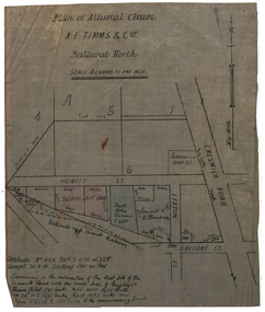
Plan, Plan of Alluvial Claim of A.E. Timms and Co, 1894, 02/04/1894
... Plan of Alluvial Claim of A.E. Timms and Co, 1894...Scale: 4 chains to 1 inch (1:3168) WGS 84 37 32 35 South 143 50 50 East Plan of Alluvial Claim of A.E. Timms and Co, 1894 Plan ...This item was removed from Catalogue Number 3601Plan of a lease located near Cresick Road. Scale: 4 chains to 1 inch (1:3168) WGS 84 37 32 35 South 143 50 50 Easttimms, a.e. timms & co., howitt st, ballarat north, creswick road, alluvial claim, mining -
 Federation University Historical Collection
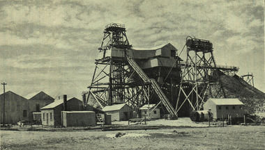
Photograph - Photograph - black and white, Talbot Alluvial Mine: working a deep lead
... Talbot Alluvial Mine: working a deep lead...Barker Library (top floor) Mount Helen goldfields Photograph included in book "Victoria: Gold and Minerals" issued by Mines Department Victoria, 1935 victoria prospecting method talbot alluvial mine gold mining mining poppet head Photograph Talbot Alluvial Mine: working a deep lead Photograph Photograph - black and white ...Photograph included in book "Victoria: Gold and Minerals" issued by Mines Department Victoria, 1935Photographvictoria, prospecting method, talbot, alluvial mine, gold mining, mining, poppet head -
 Federation University Historical Collection
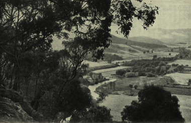
Photograph - black and white, Jamieson Valley: Broad alluvial flats of recent geological formation: Silurian and Devonian Ranges in background
... Jamieson Valley: Broad alluvial flats of recent geological formation: Silurian and Devonian Ranges in background....Barker Library (top floor) Mount Helen goldfields Photograph included in book "Victoria: Gold and Minerals" issued by Mines Department Victoria, 1935 victoria jamieson valley geological formation alluvial flats silurian devonian Photograph Jamieson Valley: Broad alluvial flats of recent geological formation: Silurian and Devonian Ranges in background. ...Photograph included in book "Victoria: Gold and Minerals" issued by Mines Department Victoria, 1935Photographvictoria, jamieson valley, geological formation, alluvial flats, silurian, devonian -
 Stawell Historical Society Inc
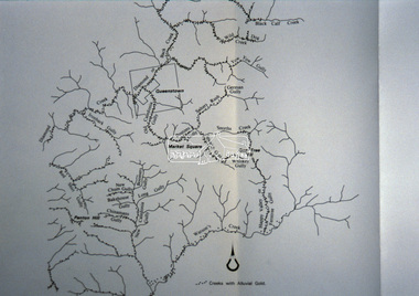
Map, Department of Mines Victoria, Alluvial Map Stawell Region, 1870's
... Alluvial Map Stawell Region...Shows geological layout. Alluvial Map Stawell Region Map Department of Mines Victoria ...c1870 Coloured map showing Black Range North to Stawell and Illawarra. Shows geological layout.Department Mines Victoria 1952/G/2 mining, gold, map -
 Rutherglen Historical Society
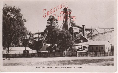
Image, F W Force, Chiltern Valley. No. 2 Gold Mine. (Alluvial.), c1900
... No. 2 Gold Mine. (Alluvial.)...No. 2 Gold Mine. (Alluvial.) Image F W Force ...Black and white postcard photograph of the upper structures of a gold mine and surrounding buildings.Printed in red at top of photo: "Greetings From Chiltern" Written on back of card: "c/o Mrs A. Smith. Melbourne Rd. Chiltern | Just a line to let you know I arrived safely and am having a good time. I went to a picnic on Easter Monday and had a great time. Did you go to the sports were they a success. We have plenty of music here Aggie plays the piano and I brought my violin up and a boy staying here from Melbourne sings. Hoping to hear from you soon. Your loving friend etc."chiltern, gold mining, mining industry, chiltern mine -
 Buninyong & District Historical Society
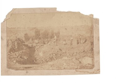
Photograph - B/W photograph of shallow alluvial mine, Sepia mining scene
... This photograph of miners at work on a shallow alluvial mine was taken around 1870 however the location, participants and precise date are unknown...Alluvial Mining late 19th century...Buninyong & District Historical Society Old Court House, Buninyong Town Hall 313 Learmonth Street Buninyong goldfields This photograph of miners at work on a shallow alluvial mine was taken around 1870 however the location, participants and precise date are unknown This scene is typical of alluvial mining during the gold rush and up to the latter part of the 19th century showing gold miners and their equipment in action Gold mining Miners Tramway Alluvial Mining late 19th century Sepia photograph of shallow mine with six miners location unknown c 1870 Sepia mining scene Photograph B/W photograph of shallow alluvial mine ...This photograph of miners at work on a shallow alluvial mine was taken around 1870 however the location, participants and precise date are unknownThis scene is typical of alluvial mining during the gold rush and up to the latter part of the 19th century showing gold miners and their equipment in actionSepia photograph of shallow mine with six miners location unknown c 1870Alluvial Mining late 19th centurygold mining, miners, tramway -
 Bendigo Historical Society Inc.
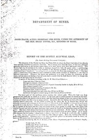
Document - STRAUCH COLLECTION: DEPT OF MINES,REPORT ON HUNTLY ALLUVIAL LEAD
... ...alluvial...1898 Victoria Department of Mines report on the Huntly Alluvial Lead with assorted maps....History House 11 Mackenzie Street Bendigo goldfields BHS Collection MINING Extraction alluvial 1898 Victoria Department of Mines report on the Huntly Alluvial Lead with assorted maps. ...BHS Collection1898 Victoria Department of Mines report on the Huntly Alluvial Lead with assorted maps.mining, extraction, alluvial -
 Clunes Museum
Photograph, C. NETTLETON, APPROX. 1865
... .1 SEPIA PHOTOGRAPH OF CLUNES ALLUVIAL GOLD MINING CO. .2 SEPIA PHOTOGRAPH OF POPPET HEAD-MINERS ON PLATFORM-THATCHED ROOF BUILDINGS, SCATTERING OF LARGE LOGS IN FOREGROUND, USED FOR FIRES. .3 COPY OF ABOVE PHOTOGRAPH IN BLACK AND WHITE (POSTCARD SIZE)....1 PRINTED: CLUNES ALLUVIAL GOLD MINING COMPANY REGISTERED CLUNES .2 PRINTED ON FRONT : ALLUVIAL GOLD MINING COMPANY REGISTERED CLUNES HANDWRITTEN: PERIOD 1865. ...RED CLAY FROM THIS MINE WAS USED FOR BRICK MAKING. photographs mining CLUNES ALLUVIAL MINING COMPANY .1 PRINTED: CLUNES ALLUVIAL GOLD MINING COMPANY REGISTERED CLUNES .2 PRINTED ON FRONT : ALLUVIAL GOLD MINING COMPANY REGISTERED CLUNES HANDWRITTEN: PERIOD 1865. ...THIS MINE WAS SITUATED ABOUT 100 YARDS SOUTH WEST OF ALBERT STREET AND ANGUS STREET CORNER. RED CLAY FROM THIS MINE WAS USED FOR BRICK MAKING..1 SEPIA PHOTOGRAPH OF CLUNES ALLUVIAL GOLD MINING CO. .2 SEPIA PHOTOGRAPH OF POPPET HEAD-MINERS ON PLATFORM-THATCHED ROOF BUILDINGS, SCATTERING OF LARGE LOGS IN FOREGROUND, USED FOR FIRES. .3 COPY OF ABOVE PHOTOGRAPH IN BLACK AND WHITE (POSTCARD SIZE).1 PRINTED: CLUNES ALLUVIAL GOLD MINING COMPANY REGISTERED CLUNES .2 PRINTED ON FRONT : ALLUVIAL GOLD MINING COMPANY REGISTERED CLUNES HANDWRITTEN: PERIOD 1865. SITUATED ABOUT 100 YDS SW OF ALBERT AND ANGUS STREET CORNER. RED CLAY FROM THIS MINE WAS USED FOR BRICK MAKINGphotographs, mining, clunes alluvial mining company -
Whitehorse Historical Society Inc.
Article, Gold discovery at Mount Waverley, 1967
... Holland, sunk a shaft and the ground for miles was pegged out and prospectors were busy in the gullies searching for alluvial gold....Holland, sunk a shaft and the ground for miles was pegged out and prospectors were busy in the gullies searching for alluvial gold....Holland, sunk a shaft and the ground for miles was pegged out and prospectors were busy in the gullies searching for alluvial gold. Gold discovery at Mount Waverley Article Article ...Article - In 1896 gold was discovered at Mount Waverley near the corner of Springvale Road and High Street Road.Article - In 1896 gold was discovered at Mount Waverley near the corner of Springvale Road and High Street Road. The discoverer, Mr P. Holland, sunk a shaft and the ground for miles was pegged out and prospectors were busy in the gullies searching for alluvial gold.Article - In 1896 gold was discovered at Mount Waverley near the corner of Springvale Road and High Street Road. mines and mining, high street road, glen waverley, springvale road, goldmining -
 Stawell Historical Society Inc
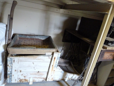
Memorabilia - Realia
... Wooden Miners Gold Cradle used for panning Alluvial Gold...Stawell Historical Society Inc 46 Longfield St Stawell grampians Stawell Wooden Miners Gold Cradle used for panning Alluvial Gold Memorabilia Realia ...Wooden Miners Gold Cradle used for panning Alluvial Goldstawell -
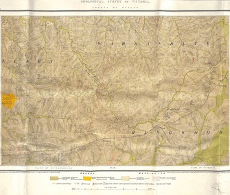 Ringwood and District Historical Society
Map, Geological Survey of Victoria - County of Evelyn, Published June 1893
... Markings include soil and rock types, alluvial gold workings, quartz reefs....Markings include soil and rock types, alluvial gold workings, quartz reefs. Geological Survey of Victoria - County of Evelyn, Published June 1893 Map ...Markings include soil and rock types, alluvial gold workings, quartz reefs.Published under the direction of A.W. Howitt F.G.S. Secretary for Mines. The Hon J.H. McColl, Minister of Mines, June 1893. Surveyed by R.A. Moon, Field Geologist, under the supervision of R.A.F. Murray, Govt Geologist. Lithographed by J. M. Coakley. -
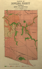 Federation University Historical Collection
Plan, Parish of Dowling Forest, County of Ripon and Grenville, 19
... Geological map on a cadastral base, showing the occurence of reefs, and alluvial deposits. Relief shown by contours....Scale [1:31 680]. 40 chains to 1 in. dowling forest wyndholm wyndholm pre-emptive right miners rest ballarat racecourse winter's swamp police reserve miner's rest winters swamp geology Geological map on a cadastral base, showing the occurence of reefs, and alluvial deposits. Relief shown by contours. ...Scale [1:31 680]. 40 chains to 1 in.Geological map on a cadastral base, showing the occurence of reefs, and alluvial deposits. Relief shown by contours.dowling forest, wyndholm, wyndholm pre-emptive right, miners rest, ballarat racecourse, winter's swamp, police reserve, miner's rest, winters swamp, geology -
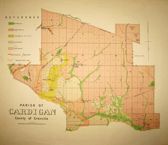 Federation University Historical Collection
Map - Geological survey, Parish of Cardigan, County of Grenville, c1889
... Geological map of the Parish of Cardigan on a cadastral base showing quartz reefs, shafts, alluvial deposits....cardigan winter's creek ballarat cattle yards railway prince of wales park, ballarat friendly societies reserve ballarat industrial school reserve green hill bunker's hill sago hill diamond drill bores cardigan propriety half way house ti tree creek albion consols prince imperial winter's freehold company Geological map of the Parish of Cardigan on a cadastral base showing quartz reefs, shafts, alluvial deposits. Parish of Cardigan, County of Grenville Map Geological survey ...Geological map of the Parish of Cardigan on a cadastral base showing quartz reefs, shafts, alluvial deposits.cardigan, winter's creek, ballarat cattle yards railway, prince of wales park, ballarat, friendly societies reserve, ballarat industrial school reserve, green hill, bunker's hill, sago hill, diamond drill bores, cardigan propriety, half way house, ti tree creek, albion consols, prince imperial, winter's freehold company -
Federation University Historical Collection
Document, Albert W. Strange, Ballarat Historical Park Description of Mining Processes & Equipment as a Guide to the Diggings and Quartz Mine, 1970, 02/1970
... Six typed pages including information onf the North Normanby Mine, deep leads at Ballarat, alluvial diggings...Barker Library (top floor) Mount Helen goldfields A guide to teh Sovereign Hill Diggings and Quartz Mine bert strange sovereign hill ballarat historical park gold diggings quartz mine north normanby mine cornish boiler deep leads ballarat east windlass alluvial diggings wash paddock windsail shanty quartz mining puddling machine hand whip horse drawn whip horse drawn whim Albert Strange Six typed pages including information onf the North Normanby Mine, deep leads at Ballarat, alluvial diggings Ballarat Historical Park Description of Mining Processes & Equipment as a Guide to the Diggings and Quartz Mine, 1970 Document Document Albert W. ...A guide to teh Sovereign Hill Diggings and Quartz MineSix typed pages including information onf the North Normanby Mine, deep leads at Ballarat, alluvial diggingsbert strange, sovereign hill, ballarat historical park, gold diggings, quartz mine, north normanby mine, cornish boiler, deep leads, ballarat east, windlass, alluvial diggings, wash paddock, windsail, shanty, quartz mining, puddling machine, hand whip, horse drawn whip, horse drawn whim, albert strange -
Clunes Museum
Memorabilia - SPECIMEN, UNKNOWN
... ...ALLUVIAL...Clunes Museum 36 Fraser Street enter building through Collins Place Clunes goldfields MINING ALLUVIAL GOLD NIL SAMPLE OF GOLD SPECIMEN IN GREEN SMALL WOODEN AND GLASS CONTAINER Memorabilia SPECIMEN ...SAMPLE OF GOLD SPECIMEN IN GREEN SMALL WOODEN AND GLASS CONTAINERNILmining, alluvial, gold -
Bendigo Historical Society Inc.
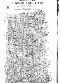
Map - GEOLOGICAL MAP BENDIGO GOLD FIELD
... Showing anticlines, synclines, shafts, alluvial, contours. Produced by the deprtment of mines. ...Showing anticlines, synclines, shafts, alluvial, contours. Produced by the deprtment of mines. ...Geological map Bendigo gold field. Showing anticlines, synclines, shafts, alluvial, contours. Produced by the deprtment of mines. Two originals plus two laminated copies -
 Bendigo Historical Society Inc.
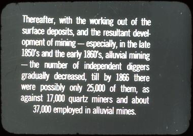
Slide - DIGGERS & MINING: DIGGERS & MINING
... Slide reads: Thereafter, with the working out of surface deposits, and the resultant development of mining - especially, in the late 1850's, alluvial mining - the number of independent diggers gradually decreased, till by 1866 there were possibly only 25,00 of them, as against 17,000 quartz miners and about 37,000 employed in alluvial mines. ...Slide reads: Thereafter, with the working out of surface deposits, and the resultant development of mining - especially, in the late 1850's, alluvial mining - the number of independent diggers gradually decreased, till by 1866 there were possibly only 25,00 of them, as against 17,000 quartz miners and about 37,000 employed in alluvial mines. ...Diggers & Mining: Diggers & Mining. Slide reads: Thereafter, with the working out of surface deposits, and the resultant development of mining - especially, in the late 1850's, alluvial mining - the number of independent diggers gradually decreased, till by 1866 there were possibly only 25,00 of them, as against 17,000 quartz miners and about 37,000 employed in alluvial mines. Markings: 52/ 994:LIF 1. Used as a teaching aid.hanimounteducation, tertiary, diggers & miners -
 Bright & District Historical Society operating the Bright Museum
Pan gold
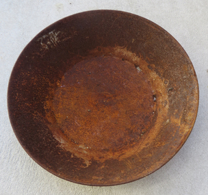
... Used for separating gold particles from alluvial deposits. After washing the alluvial gravel in water the gold is trapped in a ring on the side of the pan. ...Bright & District Historical Society operating the Bright Museum 2 Station Street Bright high-country Used for separating gold particles from alluvial deposits. After washing the alluvial gravel in water the gold is trapped in a ring on the side of the pan. ...Used for separating gold particles from alluvial deposits. After washing the alluvial gravel in water the gold is trapped in a ring on the side of the pan. This pan has a ring half way round the rim of the pan.Typical gold pan that would have been used in gold fields of North East VictoriaUsed gold pan. 300mm diametergold, gold pan, goldfields -
Lakes Entrance Historical Society
Book, Paill Raymond, Old Walhalla- Portrait of a Gold Town, 1964
... A history of the town of Walhalla victoria, from the early alluvial mining in 1860's through the heady days of rich underground mining to its rgression to a sleepy ghost town in the 1960's...Lakes Entrance Historical Society 4 Marine Parade Lakes Entrance gippsland Mines and Mining Township Transport A history of the town of Walhalla victoria, from the early alluvial mining in 1860's through the heady days of rich underground mining to its rgression to a sleepy ghost town in the 1960's Old Walhalla- Portrait of a Gold Town Book Paill Raymond ...A history of the town of Walhalla victoria, from the early alluvial mining in 1860's through the heady days of rich underground mining to its rgression to a sleepy ghost town in the 1960'smines and mining, township, transport -
 Bendigo Historical Society Inc.
Slide - DIGGERS & MINING: DIGGERS & MINING
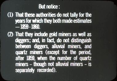
... Slide reads; But notice: (1) That these authorities do not rally for the years for which they both made estimates - 1859 - 1860. (2) That they include gold miners as well as diggers; and, in fact, do not distinguish between diggers, alluvial miners, and quartz miners (except for the periods after 1859, when the number of quartz miners - though not alluvial miners - is separately recorded). ...Slide reads; But notice: (1) That these authorities do not rally for the years for which they both made estimates - 1859 - 1860. (2) That they include gold miners as well as diggers; and, in fact, do not distinguish between diggers, alluvial miners, and quartz miners (except for the periods after 1859, when the number of quartz miners - though not alluvial miners - is separately recorded). ...Diggers & Mining: Diggers & Mining. Slide reads; But notice: (1) That these authorities do not rally for the years for which they both made estimates - 1859 - 1860. (2) That they include gold miners as well as diggers; and, in fact, do not distinguish between diggers, alluvial miners, and quartz miners (except for the periods after 1859, when the number of quartz miners - though not alluvial miners - is separately recorded). Markings: 50/ 994:LIF 1. Used as a teaching aid.hanimounteducation, tertiary, mining -
 Bendigo Historical Society Inc.
Map - LONG GULLY HISTORY GROUP COLLECTION: GEOLOGICAL MAP - BENDIGO GOLD FIELD
... Map shows Lines of Reef, Anticlines, Synclines, Shafts, Alluvial Contours Gullies and some street names. ...Map shows Lines of Reef, Anticlines, Synclines, Shafts, Alluvial Contours Gullies and some street names. ...Copy of a Geological Map of the Bendigo Gold Field. Map shows Lines of Reef, Anticlines, Synclines, Shafts, Alluvial Contours Gullies and some street names. Copy is hard to read. There are two pages.bendigo, history, long gully history group, the long gully history group - geological map - bendigo gold field, mines department, h herman, lightning hill line, hustlers line, derby line, paddy's gully line, garden gully line, deborah line, sheepshead line, new chum line, nell gwynne line, british and foreign line, napoleon line, carshalton line, thistle line, christmas line, lancashire line -
 Halls Gap & Grampians Historical Society
Photograph - B/W, C 1887
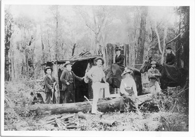
... Afred D'Alton was the first to discover alluvial good in Stony Creek...Halls Gap & Grampians Historical Society Centennial Hall 117-119 Grampians Road Halls Gap grampians Afred D'Alton was the first to discover alluvial good in Stony Creek PEOPLE D'Alton MINING Stoney Creek Larger photo taken from original Photo shows members of D/Alton family outside lean to at Stoney Creek diggings Left to Right Jim, John and Charles D/Alton, Henrietta and Amy (John's daughters) Galbraith (John's son) Clare (Charlie and Jim's sister) Photograph B/W ...Afred D'Alton was the first to discover alluvial good in Stony CreekPhoto shows members of D/Alton family outside lean to at Stoney Creek diggings Left to Right Jim, John and Charles D/Alton, Henrietta and Amy (John's daughters) Galbraith (John's son) Clare (Charlie and Jim's sister)Larger photo taken from original people, d'alton, mining, stoney creek -
 The Beechworth Burke Museum
Postcard, George Symons, c.1990
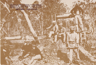
... During this period, in the 1870s, the surface alluvial gold had been discovered and removed from location. ...In order to reach less / accessible alluvial gold diggers began sinking shafts as much as twenty to thirty feet down / and the mines required timbering and winches / to bring the paydirt to the top. / This syndicate has been unable to afford the / luxury of a horse (about 50 pounds) and so everything / must go up and down by windlass and rawhide / bucket. / Photo: Mitchell Library, Sydney / A sepia tone facsimile of / an early Australian photograph...During this period, in the 1870s, the surface alluvial gold had been discovered and removed from location. ...The photograph printed on this postcard comes from the collection of the Mitchell Library in Sydney. It is sepia in tone and depicts seven men standing and sitting around a mine shaft in the Beechworth region. The photograph has been dated to approximately 1872. This period in history post-dates the Victorian gold rushes which occurred 1852-1853 in Ballarat, Bendigo and Beechworth. During this period, in the 1870s, the surface alluvial gold had been discovered and removed from location. Therefore, in order to reach the deeper and less accessible alluvial gold, diggers began to dig shafts into the earth. These shafts sunk below the ground level by 20 to 30 feet and required timber structures around the entrance and winches to bring the paydirt to the top. The top of this wooden structure is visible behind the man standing in the upper right of the image. This type of mining was highly dangerous as mines often caved in which injured the minors and often resulted in death. Thus, following this period, in the early 1900s, miners opted instead for hydrolic slucing which cut away the earth without the devastating consequences of a mine cave in. This particular group of miners appear to have been unable to afford a horse (then worth around 50 pounds) which were generally used at mines like this to help pull buckets attached to ropes up and down the mine. Instead, this group brought the buckets up and down by windlass. The windlass was a wooden structure mounted over the mining shaft and fitted with a hand-cranked winch which enabled the bucket attached to the rope to be brought up and down.Gold was first discovered in Beechworth in Spring and Reid's Creek in the summer of 1852-1853. At its popularity, this region had approximately 8000 people on the gold fields searching for gold on the banks of these creeks. These periods did not require the use of heavy machinery or the digging of deep mining shafts like the one depicted in this image. Therefore, this image has important connotations for the technologies associated with mining during the approximated 1870s when gold was harder to access. This is a later period in gold history which does not fit into the "gold rush" period. Instead, it occurred after the surface gold had disappeared and therefore, is essential for researchers who are investigating the mining techniques and structures used to reach the alluvial gold which was located deeper under ground in the 1870s. This period predates the use of big heavy machinery used to mine in the 1900s which include dredges. Images such as this one can also impart essential information as to the wardrobe and fashion of men during this period. It also imparts knowledge about the landscape of Beechworth which is useful for people researching the environment and impact of gold mining in the north-east region of Victoria. In addition, since this image is a postcard reproduction of an early Australian image which may date to approximately 1990 it can impart knowledge as to the interests of people during this time period when there may have been an increase into Australian history.A sepia tone facsimile of an early Australian photograph (circa 1872) printed as a postcard.Obverse: BEECHWORTH / Victoria, Australia / Reverse: GM 2 3275 / CORRESPONDENCE / AUSTRALIAN / YESTERYEAR / CARDS / ADDRESS / Published by George Symons (057) 65 3240 / THE MINEHEAD C. 1872 / The easily gleaned gold of the early fields did / not last very long. In order to reach less / accessible alluvial gold diggers began sinking shafts as much as twenty to thirty feet down / and the mines required timbering and winches / to bring the paydirt to the top. / This syndicate has been unable to afford the / luxury of a horse (about 50 pounds) and so everything / must go up and down by windlass and rawhide / bucket. / Photo: Mitchell Library, Sydney / A sepia tone facsimile of / an early Australian photographmining album, gold mine, beechworth, burke museum, mine shaft, postcard, australian yesteryear cards, george symons, the minehead, gold fields, alluvial gold, early australia, c.1872, 1872, gold diggers, north east victoria -
 Ballarat Heritage Services
Photograph, Clare Gervasoni, Metal Gold Pan, 2017
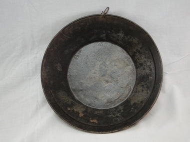
... A gold pan was used to wash alluvial gold from gravel and dirt....Ballarat Heritage Services PO Box 2209 Bakery Hill Post Office goldfields A gold pan was used to wash alluvial gold from gravel and dirt. gold pan mining gold mining tools tools Colour photographs of a large gold pan. ...A gold pan was used to wash alluvial gold from gravel and dirt.Colour photographs of a large gold pan.gold pan, mining, gold mining tools tools -
 Stawell Historical Society Inc
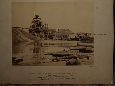
Photograph, The Homeward Bound Gold Mine in Stawell c1898
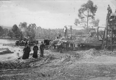
... Stawell Alluvial Mining Scene. The Homeward Bound Mine Company puddling machine c1898...Stawell Historical Society Inc 46 Longfield St Stawell grampians Stawell Alluvial Mining Scene. The Homeward Bound Mine Company puddling machine c1898 Stawell Early Mining Scene Stawell. ...Stawell Alluvial Mining Scene. The Homeward Bound Mine Company puddling machine c1898Four well dressed men and women standing in front of a steam driven puddling machine. Two horses and carts are in front of the puddler and three men standing on the machineEarly Mining Scene Stawell. Mine Believed to be "The Homeward Bound'stawell -
 Bendigo Historical Society Inc.
Slide - DIGGERS & MINING. DIGGERS AND MINERS, c1850s
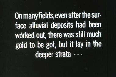
... On many fields, even the surface alluvial deposits had been worked out, there was still much gold to be got, but it lay in the deeper strata - - - Markings: 21 994:LIF I. ...On many fields, even the surface alluvial deposits had been worked out, there was still much gold to be got, but it lay in the deeper strata - - - Markings: 21 994:LIF I. ...BHS CollectionDiggers & Mining. Diggers and miners. On many fields, even the surface alluvial deposits had been worked out, there was still much gold to be got, but it lay in the deeper strata - - - Markings: 21 994:LIF I. Used as a teaching aid.hanimounteducation, tertiary, goldfields