Showing 37 items matching "altimeter"
-
 National Vietnam Veterans Museum (NVVM)
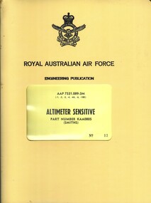
Manual, Royal Australian Air Force, Royal Australian Air Force: Altimeter sensitive P/N KAA0805
... Royal Australian Air Force: Altimeter sensitive P/N KAA0805...Through the window on yellow cardboard reads AAP 7531.089-3M Altimeter Sensitive etc....Through the window on yellow cardboard reads AAP 7531.089-3M Altimeter Sensitive etc. Royal Australian Air Force: Altimeter sensitive P/N KAA0805 Manual Royal Australian Air Force ...A yellow plastic cover with a clear window near the middle. In black is the insignia of the RAAF and royal Australian Air Force is under this. just aove the window reads Engineering Publication. Through the window on yellow cardboard reads AAP 7531.089-3M Altimeter Sensitive etc.royal australian airforce - manuals, royal australian air force, altimeter sensitive, engineering publication -
 Moorabbin Air Museum
Manual (Item) - Intercontinental Dymanics Counter Drum Pointer Pneumatic Altimeter, Installation and Operating Instructions for Counter-Drum-Pointer Pneumatic Altimeter Type 570-23932
... Installation and Operating Instructions for Counter-Drum-Pointer Pneumatic Altimeter Type 570-23932...Moorabbin Air Museum Moorabbin Airport 12 First Street Moorabbin melbourne Commonwealth Aircraft Corporation Installation and Operating Instructions for Counter-Drum-Pointer Pneumatic Altimeter Type 570-23932 Manual Intercontinental Dymanics Counter Drum Pointer Pneumatic Altimeter ...Commonwealth Aircraft Corporation -
Moorabbin Air Museum
Manual (Item) - IDC Encoding Altimeter, Installation and Operating Instructions IDC Encoding Altimeter
... Installation and Operating Instructions IDC Encoding Altimeter...Moorabbin Air Museum Moorabbin Airport 12 First Street Moorabbin melbourne Commonwealth Aircraft Corporation Library Installation and Operating Instructions IDC Encoding Altimeter Manual IDC Encoding Altimeter ...Commonwealth Aircraft Corporation Library -
Moorabbin Air Museum
Document (Item) - RAAF - Altimeter Test Set TS197B/APN - 141(V)
... RAAF - Altimeter Test Set TS197B/APN - 141(V)...Moorabbin Air Museum Moorabbin Airport 12 First Street Moorabbin melbourne AAP 7632.131 - 3M - 1 RAAF - Altimeter Test Set TS197B/APN - 141(V) Document RAAF - Altimeter Test Set TS197B/APN - 141(V) ...AAP 7632.131 - 3M - 1 -
Moorabbin Air Museum
Document (Item) - ARINC - Radio Altimeter
... ARINC - Radio Altimeter...Moorabbin Air Museum Moorabbin Airport 12 First Street Moorabbin melbourne ARINC Characteristic No.552 ARINC - Radio Altimeter Document ARINC - Radio Altimeter ...ARINC Characteristic No.552 -
Moorabbin Air Museum
Manual (Item) - RAAF Dopler Velocity Altimeter Radar, Royal Australian Air Force Dopler Velocity Altimeter Radar Set
... Royal Australian Air Force Dopler Velocity Altimeter Radar Set...Moorabbin Air Museum Moorabbin Airport 12 First Street Moorabbin melbourne RAAF Royal Australian Air Force Dopler Velocity Altimeter Radar Set Manual RAAF Dopler Velocity Altimeter Radar ...RAAF -
Moorabbin Air Museum
Manual (Item) - Bendix/King Radar Altimeter Installation Manual, Installation Manual: KRA 10/10A Radar Altimeter
... Installation Manual: KRA 10/10A Radar Altimeter...Moorabbin Air Museum Moorabbin Airport 12 First Street Moorabbin melbourne Soft-cover manual with clear front cover Installation Manual: KRA 10/10A Radar Altimeter Manual Bendix/King Radar Altimeter Installation Manual ... -
Moorabbin Air Museum
Manual (Item) - Aerosonic Corporation Technical Manual Overhaul Pressure Altimeter A-80-AAU-8/A A-80-AAU-8A/A
... Aerosonic Corporation Technical Manual Overhaul Pressure Altimeter A-80-AAU-8/A A-80-AAU-8A/A...Moorabbin Air Museum Moorabbin Airport 12 First Street Moorabbin melbourne Aerosonic Corporation Technical Manual Overhaul Pressure Altimeter A-80-AAU-8/A A-80-AAU-8A/A Manual Aerosonic Corporation Technical Manual Overhaul Pressure Altimeter A-80-AAU-8/A A-80-AAU-8A/A ... -
Moorabbin Air Museum
Manual (Item) - Smiths Industries Maintenance Manual Type 3B Altimeter Altitude Alerting System 34-10-00
... Smiths Industries Maintenance Manual Type 3B Altimeter Altitude Alerting System 34-10-00...Moorabbin Air Museum Moorabbin Airport 12 First Street Moorabbin melbourne Smiths Industries Maintenance Manual Type 3B Altimeter Altitude Alerting System 34-10-00 Manual Smiths Industries Maintenance Manual Type 3B Altimeter Altitude Alerting System 34-10-00 ... -
Moorabbin Air Museum
Manual (Item) - Altimeter Manuals
... Altimeter Manuals...Moorabbin Air Museum Moorabbin Airport 12 First Street Moorabbin melbourne Altimeter Manuals Manual Altimeter Manuals ... -
Moorabbin Air Museum
Booklet (Item) - Rockwell International Guides to ACARS HF VHF Communications Weather Radar VOR ILS Transponder Radio Altimeter ADF DME
... Rockwell International Guides to ACARS HF VHF Communications Weather Radar VOR ILS Transponder Radio Altimeter ADF DME...Moorabbin Air Museum Moorabbin Airport 12 First Street Moorabbin melbourne Rockwell International Guides to ACARS HF VHF Communications Weather Radar VOR ILS Transponder Radio Altimeter ADF DME Booklet Rockwell International Guides to ACARS HF VHF Communications Weather Radar VOR ILS Transponder Radio Altimeter ADF DME ... -
 Nhill Aviation Heritage Centre
Altimeter
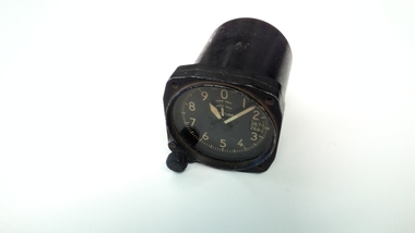
... Altimeter...Pressure tube fitting on back Altimeter ...Typical of an altimeter fitted to an aircraftBlack metal cylindrical body with glass face and clock arms. Face is numbered 1 to 0 (100 to 1000 ft) also 1000 ft and 10,000 ft scale. Preset knob and preset widow and readout. Pressure tube fitting on backAltitude 100, 1000, 10,000 ft Kollsman Instrument Division. Elmhurst New York -
 Department of Energy, Environment and Climate Action
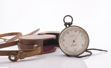
Surveyor's Pocket Altimeter, c 1940
... Surveyor's Pocket Altimeter - Aneroid Barometer Type Branded N H Seward, Melbourne. ...Surveyor's Pocket Altimeter ...This instrument measures elevation by sensing minute changes in barometric air pressure relative to a fixed datum point at sea level or a known elevation, such as the starting point of a major town during a road survey, and has an accuracy of +/- 20 feet when used in experienced hands. The finely divided scale around the perimeter of the face is marked from 0 to 6000 feet elevation and 25 to 31 inches of mercury (Hg) for barometric pressure The single fine counter-balanced hand or pointer rotates anti-clockwise with increasing elevation and decreasing pressure. The label "compensated" indicates that the instrument is constructed to compensate for the effect of temperature changes on the accuracy of readings. Surveyor's Pocket Altimeter - Aneroid Barometer Type Branded N H Seward, Melbourne. Made in England. With leather carrying case and strap.forest measurement, forests commission victoria (fcv), surveying -
 Bendigo Military Museum
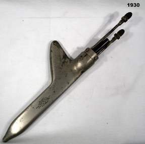
Equipment - AIRCRAFT INSTRUMENT, 1940 (exact)
... The 'Pilot Head' worked 3 flight instruments,air speed, altimeter & rate of climb....The 'Pilot Head' worked 3 flight instruments,air speed, altimeter & rate of climb. aircraft equipment pilot head "PAT NOS 2.2.04.367 Des 114.332 Pat Canada 1940 Made in USA 'Pilot Head' from an aircraft, metal & Bakelite construction, long rectangular shape rounded on edges with a fin. ...Item belonged to Maxwell Lennox MATHESON No 418447 RAAF. Refer 1959 for his service history. The 'Pilot Head' worked 3 flight instruments,air speed, altimeter & rate of climb.'Pilot Head' from an aircraft, metal & Bakelite construction, long rectangular shape rounded on edges with a fin. At rear are 3 connectors one for electrical."PAT NOS 2.2.04.367 Des 114.332 Pat Canada 1940 Made in USAaircraft, equipment, pilot head -
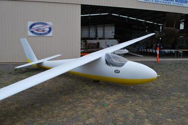
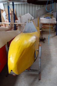 Australian Gliding Museum
Machine - Glider – Sailplane, 1949
... Instruments include airspeed indicator and altimeter tucked neatly under front edge of the cockpit rim....Instruments include airspeed indicator and altimeter tucked neatly under front edge of the cockpit rim. ...The Hutter H17 is a small single seat glider with a wing span of 9.69 metres, designed in 1934 by Wolfgang Hutter, for flying in the Austrian Alps. Construction of the museum’s example, “Sweetwings” (now registered as VH-GQM), commenced in Perth in 1949. It is one of two Hutter H17 gliders built in Western Australia by N.J. Wynne and A.G. Milligan at the time – the other “Fleetwings” (formerly VH-HDQ and since re-registered as VH-GXV) is located at Millicent, South Australia. Ownership transferred to G.R. Reichelt of Tocumwal New South Wales and later to D.B. Hunt of Thornbury in Melbourne and later Mt Isa, Queensland. It was acquired by Bill Riley of Tocumwal who donated it to the Museum. The glider was last flown on 25 October 1979 at Tocumwal. This exhibit is an example of a 1930s small wood and fabric glider that was designed in Austria for hill soaring. It is a simple design that became a popular choice for home building in the post war years in Australia when gliding as a sport was in recovery. Some examples are still flying.Small single seat glider. Fuselage and wing struts are painted yellow. Wings, rudder and tailplane / elevator are primed with pink dope. It has an open cockpit with small clear Perspex wind screen. Instruments include airspeed indicator and altimeter tucked neatly under front edge of the cockpit rim.australian gliding, glider, sailplane, hutter, sweetwings, fleetwings, reichelt, riley, wynne, milligan -
 Australian Gliding Museum
Machine - Glider – Sailplane, 1963
... The instruments are not present except for altimeter. Fin and rudder are of swept back design. ...The instruments are not present except for altimeter. Fin and rudder are of swept back design. ...This aircraft is one of 9 single seat ES 59 advanced club sailplanes manufactured by Edmund Schneider Pty Ltd in the 1960s. It was first flown in August 1963 and delivered to the Darling Downs Soaring Club at Toowoomba Queensland. At that Club it had 2603 flights and recorded a total airtime of 1475 hours. In addition to many local circuits and soaring and cross country flying, it was used at gliding competitions, including Nationals at Benalla in December 1964, State Championships at Oakey in April 1965, at Warwick in April 1966, and at (Inverell?) in March 1967. On at least 15 occasions flight times in excess of 5 hours duration were achieved. On 5 October 1970, the glider had a new life when it was relocated to Wollongong in New South Wales. It recorded 1927 flights with a total airtime of 1179 hours at the club between October 1970 and June 1988. Competition appearances included the State Championships held at Forbes in January 1972. Places away from Wollongong where the glider was launched include Cootamundra, Wagga, Temora, Marulon, Narromine, Leeton, Nowra, Goulburn, Horsham, Greenthorpe. On 15 June 1988 it was transferred to Ron Geake who transported it to Warrego in Northern Territory (flown once at Alice Springs), and then to Gympie in Queensland where it was flown about 20 times by the end of 1995. It was also flown on a small number of occasions at Forbes in New South Wales in 1996 and 1997. During 1998 and 1999 the glider was sparsely used (9 flights) at locations that have not been recorded. From May 1999 until transfer to the Australian Gliding Museum in May 2011 it apparently was not flown. Aggregate airtime hours for the glider stand at 2702 hours 53 minutes. It has been launched 4569 times. A good example of a Schneider ES59 sailplane from the 1960s. This type is of note because it was the first Australian designed and built sailplane to be used in a world gliding competition (Jack Iggulden in Argentina in 1963). This Schneider ES59 Arrow is a single seat wooden sailplane with one piece wing. The instruments are not present except for altimeter. Fin and rudder are of swept back design. Colour scheme is white with lemon yellow fuselage underbelly. The aircraft came to the museum on an open trailer that had been designed to carry the one piece wing. Plate in cockpit with details of manufacturer states; manufactured by E. Schneider Ltd, Adelaide SA; Type ES 59; Serial Number 62; Date August 1963.australian gliding, glider, sailplane, schneider, es59, arrow, darling downs soaring club, wollongong gliding club, ron geake -
 Australian Gliding Museum
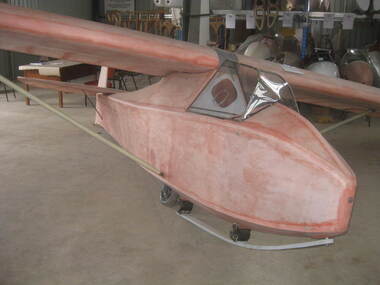
Machine - Glider – Sailplane, 1940
... Wood and fabric single seat glider sailplane with strutted wings and strutted tailplane – features metal framed perspex canopy, central fuselage skid and wheel, small tail skid, instruments include airspeed, turn and bank indicator; variometer and altimeter. Metal parts include struts and fairing covering wing joint. ...Also the aircraft provides an insight into gliding technology in Australia in the 1940s. australian gliding glider sailplane coogee tom proctor victorian motorless flight group geelong gliding club Wood and fabric single seat glider sailplane with strutted wings and strutted tailplane – features metal framed perspex canopy, central fuselage skid and wheel, small tail skid, instruments include airspeed, turn and bank indicator; variometer and altimeter. Metal parts include struts and fairing covering wing joint. ...The “Coogee” is an intermediate single seat sailplane designed and built by Tom Proctor in 1940. Only one was built. It was first flown at Stuart Hill near Bendigo Victoria in January 1941 and was maintained in flying condition until 1967. The aircraft was flown extensively by the Victorian Motorless Flight Group (now the Melbourne Gliding Club) and Geelong Gliding Club and several subsequent owners. This exhibit is a "one off" Australian designed and built glider similar in some respects to the Hutter H17. Its usage is relevant to the history of gliding in Victoria in the post war years. Also the aircraft provides an insight into gliding technology in Australia in the 1940s. Wood and fabric single seat glider sailplane with strutted wings and strutted tailplane – features metal framed perspex canopy, central fuselage skid and wheel, small tail skid, instruments include airspeed, turn and bank indicator; variometer and altimeter. Metal parts include struts and fairing covering wing joint. All surfaces are pink doped – awaiting painting.australian gliding, glider, sailplane, coogee, tom proctor, victorian motorless flight group, geelong gliding club -
 Bendigo Military Museum
Administrative record - The Airborne Profile Recorder (APR) Ballarat Test Area, Captain EP Constantine RASvy, Circa 1962
... The Airborne profile Recorder (APR) is a precise airborne radar altimeter designed to provide a continuous record of terrain clearance, (the distance between the aircraft and the ground surface). ...Bendigo Military Museum 37 - 39 Pall Mall Bendigo goldfields The Airborne profile Recorder (APR) is a precise airborne radar altimeter designed to provide a continuous record of terrain clearance, (the distance between the aircraft and the ground surface). ...The Airborne profile Recorder (APR) is a precise airborne radar altimeter designed to provide a continuous record of terrain clearance, (the distance between the aircraft and the ground surface). This document was condensed from a report by Captain E P Constantine RASvy Corps to test the viability of using APR for acquiring height information for mapping purposes. This document was on forwarded to the ExFortuna Survey Assoc by 4 Fd Svy Sqn in Aug 2025.21 x pages of typed text and diagrams on letter sized paper, stapled top left corner. Three and four hole punched.royal australian survey corps, rasvy, fortuna, army survey regiment, army svy regt, asr -
 Bendigo Military Museum
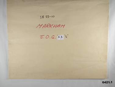
Map - SB55-10 Markham Joint Operations Graphics Air and Ground print separations, Royal Australian Survey Corps, Bendigo, Dec 1981
... The ground users required that heights and measurements were in Metres, whilst air users required height information in Feet for altimeters. The Air Version also contained more Aeronautical information including safe flying height information called Maximum Elevation Figures (MEF). ...The ground users required that heights and measurements were in Metres, whilst air users required height information in Feet for altimeters. The Air Version also contained more Aeronautical information including safe flying height information called Maximum Elevation Figures (MEF). ...This set of map prints was assembled as a training aid. The collection is a complete set of individual color prints of each colour used on the final printed maps for each map Joint Operations Graphic (JOG) JOG Ground and JOG Air versions. This map series was produced in two versions to help coordinate military Ground Operations and Air Operations. The ground users required that heights and measurements were in Metres, whilst air users required height information in Feet for altimeters. The Air Version also contained more Aeronautical information including safe flying height information called Maximum Elevation Figures (MEF). Later printing of JOG incorporated printing in just four colours Cyan, Magenta, Yellow and Black (CMYK). Item 6421.1 is an example of a JOG Ground and item 6421.2 is an example of its matching JOG Air version.1:250,000 SB55-10 Markham JOG A and G colour separations bound together in a manilla card covered folder bound with a timber edge. royal australian survey corps, rasvy, fortuna, army survey regiment, army svy regt, asr -
 Australian Gliding Museum
Machine - Glider – Sailplane, 29/071956
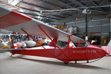
... The instrument panels in both cockpits are fitted with an airspeed indicator, cosim variometer and altimeter. This red and silver painted wood and fabric covered aircraft is in excellent condition having been restored to full airworthy status by the Australian Gliding Museum. ...The instrument panels in both cockpits are fitted with an airspeed indicator, cosim variometer and altimeter. This red and silver painted wood and fabric covered aircraft is in excellent condition having been restored to full airworthy status by the Australian Gliding Museum. ...The Slingsby T31 is a two seat training glider that came available in 1951. It is, in effect, a two seat version of the single seat Kirby Tutor. The T31 was marketed by Slingsby Sailplanes both as complete aircraft and kits of parts for assembly. The Australian Gliding Museum’s example (currently registered as VH-GDB) is one of five of this type to grace Australian skies. Three including GDB were assembled in Australia from kits supplied by Slingsby’s in England, the other two were delivered as completed airframes. To date only four remain of which two are airworthy. This aircraft began flying in at Caversham in Western Australia (the then home of the Gliding Club of Western Australia) in July 1956. It was badly damaged in a crash in June 1958. The wreckage was sent to Schneiders in Adelaide for repair. However, the Club decided against having the repairs done, opting instead to buy a new ES52 Kookaburra. After a couple of years, the wreck was purchased by a member of the Waikerie Gliding Club whereupon the glider was rebuilt with some modifications, including a more rounded and better streamlined fuselage nose. It returned to the air in October 1961 at Clare in South Australia. The ownership of VH-GDB passed through a number of clubs, including at Dubbo in New South Wales, Wimmera in Victoria and Pioneer Valley at Mackay in Queensland. Eventually, it came into the hands of Bill Riley of Tocumwal in New South Wales who held it in storage for many years. Riley donated the aircraft to the Museum. It has been restored to airworthiness and is flown at vintage glider rallies and on Museum open days. This exhibit is an excellent example of a Slingsby T31 Tandem Tutor, a type of glider that was used by a number of clubs in the 1950s and 1960s for dual training of pilots to the solo capability.The Slingsby T31b Tandem Tutor is an open cockpit, tandem, two-seater glider with high, pylon mounted two piece wing supported by double, wire braced, steel tube struts. The glider is fitted with a main wheel, rubber-block sprung, wooden nose skid and steel leaf sprung, brass shod tailskid. The basic controls of aileron, rudder and elevator are not supplemented with pitch trim. Wing lift spoilers and both aerotow and winch releases are fitted. The instrument panels in both cockpits are fitted with an airspeed indicator, cosim variometer and altimeter. This red and silver painted wood and fabric covered aircraft is in excellent condition having been restored to full airworthy status by the Australian Gliding Museum. SLINGSBY – T31b (nose – both sides) DB Australian Gliding Museum (rudder – both sides) It has been given Serial Number GFA/HB/12 and is registered as VH-GDBaustralian gliding, glider, sailplane, slingsby, tandem tutor, t31, gliding club of western australia, waikerie gliding club, wimmera soaring club, pioneer valley soaring club -
Moorabbin Air Museum
Manual - Lockheed Hercules technical training, Customer Training Electronics
... ...Altimeter...Moorabbin Air Museum Moorabbin Airport 12 First Street Moorabbin melbourne Lockheed Hercules technical training Equipment installation Gables intercommunication system Voice recorders Flight recorders Emergency transmitter HF/VHF Distance measuring equipment Beacon Transponder Altimeter Weather radar system Flight director system Magnetic compass Autopilot Doppler radar Technical overview of Hercules electronics systems, circa 1976 Customer Training Electronics Manual Lockheed Hercules technical training ...Technical overview of Hercules electronics systems, circa 1976non-fictionTechnical overview of Hercules electronics systems, circa 1976equipment installation, gables intercommunication system, voice recorders, flight recorders, emergency transmitter, hf/vhf, distance measuring equipment, beacon, transponder, altimeter, weather radar system, flight director system, magnetic compass, autopilot, doppler radar -
 Australian Gliding Museum
Machine - Glider – Sailplane, Construction completed 1952
... The instrument panel includes altimeter, airspeed indicator, slip indicator and variometers. ...The instrument panel includes altimeter, airspeed indicator, slip indicator and variometers. ...This unique aircraft was conceived in 1943 as a two seat trainer. A very large part of the design work can be attributed to Jock Barratt and Harold Bradley. The general layout adopted is similar to the Kite I and Kite II single seat sailplanes of Martin Warner and Allan Campbell. Having regard to this heritage, the glider was originally named Kite III but renamed Pelican 2, perhaps because it was the second two seat training glider built by the Waikerie Gliding Club – the first being the Pelican, a reconfigured Pratt Utility glider. Pelican 2 was first flown in 1952 and regularly since then, at least until about 1992. The Pelican 2’s performance was found to be very good for sailplanes of its era and was often used for more advanced flying in addition to training new pilots. Very few changes have been made to the Pelican 2 over the years. The undercarriage was modified after its initial testing to improve the placement of the wheels. The trailing edge of the rudder (originally straight) was rounded adding to the surface area. The twin shoulder tow line bridles were replaced with a belly hook when aviation design rules declared shoulder bridles dangerous and a nose hook has since been added to allow for aero-towing. A unique home grown sailplane design associated with Australian gliding pioneers Wooden 2 seat glider sailplane with fabric covering. Distinctive features include the pod and boom fuselage with side by side seating for pilot and a second person. The canopy of perspex supported by aluminum framing opens with port and starboard segments separately folding upwards and forward. The instrument panel includes altimeter, airspeed indicator, slip indicator and variometers. In addition to the usual controls, there is a trim operated by a small wheel mounted centrally, at head height, on the bulkhead at the rear of the cockpit. Incorporated in the skid under the fuselage pod are two wheels (one approximately midships and the other at the rear end). It has a three piece cantilever wing of approximately nearly 17 metres. The ailerons run almost full length of the outer wing segments. A Gottingen 426 section has been used changing to M6 at the tips. Outer wing segments are joined to the centre section to give about 300 mm of dihedral at the tips. The glider is equipped with airbrakes. The colour scheme consists of orange fuselage with black nose and skid. The tailplane / elevator and rudder are painted white. The wing is predominantly white with an orange leading edge. Registration VH-GFY On each side of rudder – “Pelican II” in black lettering on a rectangle of silver On each side of fuselage pod the letters ‘FY’ On each side of the fuselage, below the edge of the cockpit opening – “WAIKERIE” in black paint. australian gliding, glider, sailplane, kite, pelican, waikerie gliding club, jock barratt, harold bradley, martin warner, allan campbell -
 Bendigo Military Museum
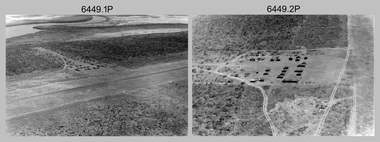
Photograph - RA Svy Project C4 Aerodist Operation, Eastern Arnhem Land, NT, 1967
... Unidentified survey operations base, L to R: unidentified technician. .11) - Unidentified technician reading two survey altimeters to compute corrections to the measured distances for atmospheric refraction and to compute the sea level distances from the slope distances aircraft to the ground stations. .12) - Photo, black & white, 1967. ...Unidentified survey operations base, L to R: unidentified technician. .11) - Unidentified technician reading two survey altimeters to compute corrections to the measured distances for atmospheric refraction and to compute the sea level distances from the slope distances aircraft to the ground stations. .12) - Photo, black & white, 1967. ...This is a set of 30 photographs of Royal Australian Survey Corps (RA Svy) personnel from Central Comd Fd Svy Unit (Adelaide) on Aerodist survey operation - Project C4 in Eastern Arnhem Land, Northern Territory in 1967. Photos of personnel were taken either at the operations base at Numbulwar or the main base at Gove (Nhulunbuy). RA Svy conducted nineteen Aerodist operations for 12 years from 1964 to 1975. Aerodist MRC2 was a tellurometer-based system adapted for aircraft to accurately measure distances between non-intervisible ground survey stations, using the aircraft as an intermediate station. Lower order geodetic results could be achieved by survey network trilateration. The measured distances between stations formed survey networks from which each station’s latitude and longitude was computed. Aerodist MRC2 was RA Svy’s major horizontal control survey tool for mainly medium scale topographic mapping (scale 1:100,000 Class A being spatially accurate to within 50 metres) in PNG, northern NT, north-west WA, Kalimantan Barat (West) Indonesia, Sumatra Indonesia, Gulf of Carpentaria and Cape York, QLD. In 1967, the Aerodist MRC2 Master equipment was installed in the aircraft featured in this set of photos, Executive Air Services’ (Essendon VIC) Grand Aero Commander VH-EXX. It was the same aircraft type and company contracted to Division of National Mapping for Aerodist MRC2 surveys. From July to October 1967 the aircraft was attached to Central Comd Fd Svy Unit (Adelaide - Major Don Ridge) on Project C4 eastern-Arnhem Land NT, where 317 Aerodist lines measuring 17,300 line miles were successfully completed. This was the most productive Aerodist project thus far. The most common helicopter used by RA Svy up to 1972 was the civilian Bell 47G-2 and the Sioux Light Observation Helicopters (LOH), the Australian Army’s equivalent featured in this photo set. These light observation helicopters had a limiting load carrying capacity of up to about 500 pounds. By comparison, one Aerodist team including two people weighed up to 1,500 pounds. Source: Royal Australian Survey Corps – Aerodist Years 1964-1975 by Peter Jensen. Refer to Item 9061.26P for more photos taken during this Aerodist survey operation.This is a set of 30 photographs of Royal Australian Survey Corps (RA Svy) personnel on Aerodist survey operations in Eastern Arnhem Land, Northern Territory in 1967. The photographs are on 35mm negative film and scanned at 96 dpi. They are part of the Army Survey Regiment’s Collection. .1) to .4) - black & white, 20th August 1967, Project C4 Aerodist Operations Base - Numbulwar, NT. .5) - Photo, black & white, 1967. Probable wrecked Indonesian fishing vessel. .6) to .8) - Photo, black & white, 1967. Unidentified survey operations base, L to R: unidentified personnel. .9) - Photo, black & white, 1967. Unidentified survey operations base, unidentified soldier driving a Haflinger 4x4 Light utility vehicle. .10) - Photo, black & white, 1967. Unidentified survey operations base, L to R: unidentified technician. .11) - Unidentified technician reading two survey altimeters to compute corrections to the measured distances for atmospheric refraction and to compute the sea level distances from the slope distances aircraft to the ground stations. .12) - Photo, black & white, 1967. Survey operations base, L to R: unidentified (x3), W01 Pat Wood BEM, unidentified. .13) to .16) - Photo, black & white, 1967. Unidentified personnel operating remote Aerodist MRC2 ground instruments. .17) to .18) - Photo, black & white, 1967. Unknown RA Svy office location. .19) to .20) - Photo, black & white, 1967. Aerodist MRC2 Master equipment. .21) to .22) - Photo, black & white, 1967. Aero Commander VH-EXX probably at Gove, NT, Central Comd Fd Svy Unit (Adelaide) – OC Major Don Ridge. .23) to .25) - Photo, black & white, 1967. Aero Commander VH-EXX probably at Gove, NT. Unidentified personnel. .26) - Photo, black & white, 1967. Aero Commander VH-EXX probably at Gove, NT. Aerodist antenna pods are visible on the aircraft. .27) to .29) - Photo, black & white, 1967. Australian Army Sioux Light Observation Helicopter (LOH) probably at Gove, NT. .30) - Photo, black & white, 1967. Panelled U337 survey station, visible as a white cross on aerial identification photo..1P to .2P – date and location on edge of film negative. .5P to .28P – no annotations .29P - annotated in white ‘RW-JEP Gove NT’ .30P - annotated in white ‘U337 Spool No1 Jun67’royal australian survey corps, rasvy, army survey regiment, army svy regt, fortuna, asr, aerodist, surveying, central comd fd svy unit -
 Bendigo Military Museum
Map - RASvy " Map Makers Exhibition 2025 "- Map display, RAN Hydrographic Office, 1972 - 1992
... Contours and height information was shown in feet to be compatible with aircraft altimeters. Each graticule square also contained a Maximum Safe Elevation Figure (MEF) also in feet. ...Contours and height information was shown in feet to be compatible with aircraft altimeters. Each graticule square also contained a Maximum Safe Elevation Figure (MEF) also in feet. ...All of these Charts / Maps were used for the RSL Museum display " The Mapmakers " ( of RASvy. ) 10 Jun - 10 Aug 2025. .1 Catalogue of Tactical Pilotage Charts, 1:500 000 Scale. Digital Data Base available as at 30Jun 92. This catalogue page shows the extent of the Australian area of responsibility for aeronautical charting. .2 RAAF PLOTTING CHART. NP 22-2 (Navigational Plotting) Tasmania. MERCATOR PROJECTION. This series of charts were used for the training of RAAF Navigators. These charts were produced and printed at the Army Survey Regiment, Bendigo. .3 RAAF PLOTTING CHART AUSTRALIA - SOUTHEAST. NP 27 is Based on LAMBERT CONFORMAL CONIC PROJECTION. This series of charts was used by RAAF Navigators for the planning of RAAF flights. These charts were produced and printed at the Army Survey Regiment, Bendigo. .4 RAAF LONG RANGE PLOTTING CHART. NP 43-4 AUSTRALIA WESTERN. MERCATOR PROJECTION. This series of maps were used for the planning of RAAF flights. Of Particular note these charts were used to plot "Rhumb Lines or loxodromes" where a course crosses all Meridians (Lines of latitude and longitude) at the same angle. On Mercator projection charts Rhumb lines are conveniently shown as straight lines and are also lines of constant compass bearing. Rhumb lines are usually longer than the shortest distance between two points. The shortest distance between two points on the earth's surface is called a "Great Circle Route" which is a route on a circular path on the surface of the earth where the centre of that circle is also the centre of the earth. Great Circle Routes on a Mercator Projection are however curves and harder to plot. These charts were produced and printed at the Army Survey Regiment, Bendigo. .5 RAAF LONG RANGE PLOTTING CHART. NP 43-7 SOLOMON ISLANDS. MERCATOR PROJECTION. Used for the planning of RAAF flights. .6 RAAF AIR STAFF PLANNING CHART NS 137-1 DARWIN NORTH WEST. AZIMUTHAL EQUIDISTANT PROJECTION. This series of charts were used for planning by the staff. The whole chart was produced by joining the four quadrant maps together. The charts are based on a single point of tangency (in this case Darwin) and shows radius (distance) in nautical miles to and from that point. A series of charts were produced centred on each of the major airfields in Northern Australia. These charts were produced and printed at the Army Survey Regiment, Bendigo. .7 RAAF AIR STAFF PLANNING CHART NS 137-2 DARWIN NORTH EAST. AZIMUTHAL EQUIDISTANT PROJECTION. Used for the planning by the staff. The charts are based on a point of tangency and show radius in nautical miles. .8 RAAF AIR STAFF PLANNING CHART NS 137-4 DARWIN SOUTH WEST. AZIMUTHAL EQUIDISTANT PROJECTION. Used for the planning by the staff. The charts are based on a point of tangency and show radius in nautical miles. .9 RAAF AIR STAFF PLANNING CHART NS 137-3 DARWIN SOUTH EAST. AZIMUTHAL EQUIDISTANT PROJECTION. Used for the planning by the staff. The charts are based on a point of tangency and show radius in nautical miles. .10 TACTICAL PILOTAGE CHART. TPC R-13B. LAMBERT CONFORMAL PROJECTION. Used by pilots for flight planning and could be used in flight if necessary for visual navigation using major ground features shown on the chart. These charts also contained aeronautical information such as airfields, radio navigation beacons and obstructions. Contours and height information was shown in feet to be compatible with aircraft altimeters. Each graticule square also contained a Maximum Safe Elevation Figure (MEF) also in feet. Coverage of this series over Australia's area of interest were produced and printed at the Army Survey Regiment, Bendigo. .11 HYDROGRAPHIC CHART. AUS 158. PORT PHILLIP SOUTH and WEST CHANNELS. PROJECTION TRANSVERSE MERCATOR. Used by all people needing to navigate a vessel. Hydrographic charts were printed at the Army Survey Regiment, Bendigo. .12 HYDROGRAPHIC CHART. AUS 157. GEELONG HARBOUR and APPROACHES. PROJECTION TRANSVERSE MERCATOR. Used by all people needing to navigate a vessel. .13 EN ROUTE CHART. AUSTRALIA ERC HIGH. H1 and H2. LAMBERT CONFORMAL CONIC PROJECTION. This series of charts were regularly produced by the RAAF Aeronautical Information Service (AIS) and contained current aeronautical information for pilots. These charts were printed at the Army Survey Regiment, Bendigo..1 Tactical Pilotage Chart Series Catalogue. Current as at 30 Jun 92. .2 Extract of Navigational Plotting Chart " NP22-2 Tasmania " .3 Extract of Navigational Plotting Chart " NP 27 RAAF PLOTTING CHART AUSTRALIA - SOUTHEAST " .4 Extract of Navigational Plotting Chart " RAAF LONG RANGE PLOTTING CHART NP43-4 AUSTRALIA WESTERN " .5 Extract of Navigational Plotting Chart " RAAF LONG RANGE PLOTTING CHART NP43-7 SOLOMON ISLANDS " .6 Extract of Navigational Series " RAAF AIR STAFF PLANNING CHART NS 137-2 DARWIN NORTH WEST " .7 Extract of Navigational Series " RAAF AIR STAFF PLANNING CHART NS 137-1 DARWIN NORTH EAST " .8 Extract of Navigational Series " RAAF AIR STAFF PLANNING CHART NS 137-4 DARWIN SOUTH WEST " .9 Extract of Navigational Series " RAAF AIR STAFF PLANNING CHART NS 137-3 DARWIN SOUTH EAST " .10 Extract of Tactical Pilotage Chart " TPC R-13B " .11 Extract of Hydrographic Chart " PORT PHILLIP SOUTH and WEST CHANNELS " .12 Extract of Hydrographic Chart " GEELONG HARBOUR and APPROACHES " .13 Extract of En Route Chart " AUSTRALIA ERC HIGH " " H1 and H2 " royal australian survey corps, rasvy, fortuna, detachment - army survey regiment, army svy regt, asr -
Moorabbin Air Museum
Document - altimeters number 120/80 issue 1, RAAF staff requirement for altimeters
... Moorabbin Air Museum Moorabbin Airport 12 First Street Moorabbin melbourne RAAF staff requirement for altimeters Document altimeters number 120/80 issue 1 ... -
Moorabbin Air Museum
Document (item) - parts catalogue horizon indicator banking rate of climb pitot machmeter operation service overhaul, CAC Sensitive Altimeters
... Moorabbin Air Museum Moorabbin Airport 12 First Street Moorabbin melbourne CAC Sensitive Altimeters Document parts catalogue horizon indicator banking rate of climb pitot machmeter operation service overhaul ... -
Moorabbin Air Museum
Manual (Item) - Handbook Of Overhaul Instructions With Parts Catalogue Types C,D And H Altimeters Kollsman
... No.05-30-3 Handbook Of Overhaul Instructions With Parts Catalogue Types C,D And H Altimeters Kollsman Manual Handbook Of Overhaul Instructions With Parts Catalogue Types C,D And H Altimeters Kollsman ...T.O. No.05-30-3 -
Moorabbin Air Museum
Book - Meteorology, Meteorological Handbook for Pilots and Navigators
... Moorabbin Air Museum Moorabbin Airport 12 First Street Moorabbin melbourne Meteorology Cloud & fog Weather Air density Visibility Altimeters Weather maps Miscellaneous UK air ministry overview of meteorology for pilots & navigators, circa 1942 Meteorological Handbook for Pilots and Navigators Book Meteorology ...UK air ministry overview of meteorology for pilots & navigators, circa 1942non-fictionUK air ministry overview of meteorology for pilots & navigators, circa 1942cloud & fog, weather, air density, visibility, altimeters, weather maps, miscellaneous -
Moorabbin Air Museum
Manual - CASA VFR flight guides, CASA VFR Flight Guide Issued December 1999
... Moorabbin Air Museum Moorabbin Airport 12 First Street Moorabbin melbourne VFR flight guides Licensing Pilot responsibilities Radio telephony procedures Conversions Altimeter setting Rules of the Air Aerodrome markings Pre flight procedures Operations CASA overview of regulations / restrictions circa 1999 Spiral bound CASA VFR Flight Guide Issued December 1999 Manual CASA VFR flight guides ...CASA overview of regulations / restrictions circa 1999Spiral boundnon-fictionCASA overview of regulations / restrictions circa 1999licensing, pilot responsibilities, radio telephony procedures, conversions, altimeter setting, rules of the air, aerodrome markings, pre flight procedures, operations -
Moorabbin Air Museum
Manual (Item) - Ansett RAAF Altimeters Airspeed and Rate Of Climb Indicators General
... Manual Ansett RAAF Altimeters Airspeed and Rate Of Climb Indicators General. ...RAAF Publication 414