St Kilda Historical Society
Photograph - Photo map, 12/04/1966
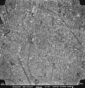
... ...Amadale...For correlation with a current map, and access to other historical photo maps of Victoria, see the Historic Photo-Maps Index published by the Department of Environment, Land, Water and Planning at https://services.land.vic.gov.au/DELWPmaps/historical-photomaps/ St Kilda St Kilda East Balaclava Toorak Amadale Caulfield South Yarra St Kilda Botanical gardens Peanut farm 1966 Vic 1933 Melbourne 1966 Project Run 12 12.4.66 Lens 122 151.75MM 9.800 154 Black and white aerial photograph Photograph Photo map ...
One of a series of photo-maps produced for the Department of Crown Lands and Survey (1857-1983). For correlation with a current map, and access to other historical photo maps of Victoria, see the Historic Photo-Maps Index published by the Department of Environment, Land, Water and Planning at https://services.land.vic.gov.au/DELWPmaps/historical-photomaps/Black and white aerial photographVic 1933 Melbourne 1966 Project Run 12 12.4.66 Lens 122 151.75MM 9.800 154st kilda, st kilda east, balaclava, toorak, amadale, caulfield, south yarra, st kilda botanical gardens, peanut farm, 1966