Showing 13 items matching "anglesea map"
-
 Anglesea and District Historical Society
Map, Royal Australian Survey Corps, Anglesea, Victoria, 1954
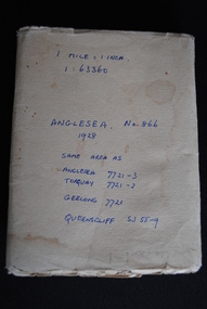
... anglesea map...Anglesea and District Historical Society 5B McMillan Street Anglesea great-ocean-road anglesea map topographic map (See above) Anglesea, Victoria [cartographic material] produced by Royal Australian Survey Corps. ...Anglesea, Victoria [cartographic material] produced by Royal Australian Survey Corps. Colour; Scale [1:63,360] 1 mile to 1 inch; transverse Mercator projection; Sheet No. 866, Zone 7. Two stamps: 1. Rankine and Dobbie Pty Ltd. 2. Authorised for sale / Price 2/- / By Department of the Army Original date: November 1928.(See above)anglesea map, topographic map -
 Bendigo Military Museum
Map - MAPS, GEELONG & ANGLESEA, 1928 - 1929
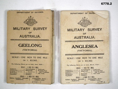
... Military Survey map of Australia - Anglesea, Vic. One inch to one mile - the map is in colour print. ...Swatton, Refer to Cat 6719.2P Anglesea Military Survey maps Geelong Victoria Passchendaele barracks trust 1. ...J.W. Swatton, Refer to Cat 6719.2P1. Military Survey map of Australia - Geelong, Vic. One inch to One mile - the map is in colour print. The two outer covers are cardboard, the map then opens up in a multifold manner. Date June 1928 2. Military Survey map of Australia - Anglesea, Vic. One inch to one mile - the map is in colour print. The two outer covers are cardboard. The map then opens up in a multi fold manner. Date March 1929.anglesea, military survey maps, geelong, victoria, passchendaele barracks trust -
 Otway Districts Historical Society
Book - Family History, Doris Robbins, William Evans 1929-19/06/1885 and Catherine Carmody 1833-14/01/1909, 1998
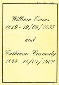
... Anglesea, Wales, in 1829, migrated to Australia in 1857. He was appointed Assistant Lighthouse Keeper at Cape Otway Lighthouse in 1858, and married Catherine Carmody on the 14 May,1860. William and Catherine spent 22 years at Cape Otway. From this union, until August 1998, eight generations of children were recorded. The book explores the lives of these children. william evans catherine carmody cape otway lighthouse William Evans (1829-19 Jun 1885) and Catherine Carmody (1833- 14 Jan 1909), Doris Robbins. Self published; Colac (Vic); c.1998. 238 p.; illus, maps ...William Evans, being born in Anglesea, Wales, in 1829, migrated to Australia in 1857. He was appointed Assistant Lighthouse Keeper at Cape Otway Lighthouse in 1858, and married Catherine Carmody on the 14 May,1860. William and Catherine spent 22 years at Cape Otway. From this union, until August 1998, eight generations of children were recorded. The book explores the lives of these children.William Evans (1829-19 Jun 1885) and Catherine Carmody (1833- 14 Jan 1909), Doris Robbins. Self published; Colac (Vic); c.1998. 238 p.; illus, maps. Soft cover.william evans, catherine carmody, cape otway, lighthouse -
 Bendigo Historical Society Inc.
Document - J W SWATTON COLLECTION: RACV ROUTE MAPS
... Four RACV Route Maps and Touring Information, Bendigo to Alexandra via Seymour and Yea, Bendigo to Mt Gambier and return, Bendigo to Horsham via Ararat and Bendigo to Anglesea, dated 1 March 76. ...History House 11 Mackenzie Street Bendigo goldfields J W Swatton Collection Royal Automobile Club of Victoria Four RACV Route Maps and Touring Information, Bendigo to Alexandra via Seymour and Yea, Bendigo to Mt Gambier and return, Bendigo to Horsham via Ararat and Bendigo to Anglesea, dated 1 March 76. ...Four RACV Route Maps and Touring Information, Bendigo to Alexandra via Seymour and Yea, Bendigo to Mt Gambier and return, Bendigo to Horsham via Ararat and Bendigo to Anglesea, dated 1 March 76. Also an unsigned Safe Driving Pledge.j w swatton collection, royal automobile club of victoria -
 Sunshine and District Historical Society Incorporated
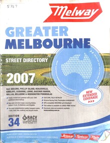
Book - Melway Greater Melbourne Street Directory 2007, Melway Publishing Pty Ltd, 2007
... maps of Great Melbourne area. In this Melway the coverage extends from Wallan, Whittlesea and Kinglake in the North to Mornington Peninsula in the South, Warburton and Tynong in the East to Bacchus Marsh and Geelong in the West. Regional areas of Gisborne, Torquay, Anglesea ...The series of Melway Directories provides the most comprehensive maps of Great Melbourne area. In this Melway the coverage extends from Wallan, Whittlesea and Kinglake in the North to Mornington Peninsula in the South, Warburton and Tynong in the East to Bacchus Marsh and Geelong in the West. Regional areas of Gisborne, Torquay, Anglesea, Lorne and Phillip Island are also included. Past editions of the Melway can provide invaluable material for researchers and historians.Paper back book with plastic jacketnon-fictionThe series of Melway Directories provides the most comprehensive maps of Great Melbourne area. In this Melway the coverage extends from Wallan, Whittlesea and Kinglake in the North to Mornington Peninsula in the South, Warburton and Tynong in the East to Bacchus Marsh and Geelong in the West. Regional areas of Gisborne, Torquay, Anglesea, Lorne and Phillip Island are also included. Past editions of the Melway can provide invaluable material for researchers and historians. -
 Sunshine and District Historical Society Incorporated
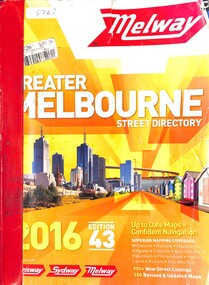
Book - Melway Greater Melbourne Street Directory 2016, Melway Publishing Pty Ltd, 2016
... maps of Great Melbourne area. In this Melway the coverage extends from Wallan, Whittlesea and Kinglake in the North to Mornington Peninsula in the South, Warburton and Tynong in the East to Bacchus Marsh and Geelong in the West. Regional areas of Kilmore, Macedon, Gisborne, Riddells Creek, Bannockburn, Torquay, Anglesea ...The series of Melway Directories provides the most comprehensive maps of Great Melbourne area. In this Melway the coverage extends from Wallan, Whittlesea and Kinglake in the North to Mornington Peninsula in the South, Warburton and Tynong in the East to Bacchus Marsh and Geelong in the West. Regional areas of Kilmore, Macedon, Gisborne, Riddells Creek, Bannockburn, Torquay, Anglesea, Lorne, Phillip Island and Koo Wee Rup are also included. Past editions can provide invaluable material for researchers and historians.Paper back booknon-fictionThe series of Melway Directories provides the most comprehensive maps of Great Melbourne area. In this Melway the coverage extends from Wallan, Whittlesea and Kinglake in the North to Mornington Peninsula in the South, Warburton and Tynong in the East to Bacchus Marsh and Geelong in the West. Regional areas of Kilmore, Macedon, Gisborne, Riddells Creek, Bannockburn, Torquay, Anglesea, Lorne, Phillip Island and Koo Wee Rup are also included. Past editions can provide invaluable material for researchers and historians. -
 Sunshine and District Historical Society Incorporated
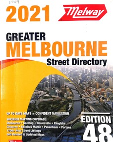
Book - Melway Greater Melbourne Street Directory 2021, Melway Publishing Pty Ltd, 2021
... maps of Great Melbourne area. In this Melway the coverage extends from Wallan, Whittlesea and Kinglake in the North to Mornington Peninsula in the South, Warburton and Tynong in the East to Bacchus Marsh and Geelong in the West. Regional areas of Kilmore, Macedon, Gisborne, Riddells Creek, Bannockburn, Torquay, Anglesea ...The series of Melway Directories provides the most comprehensive maps of Great Melbourne area. In this Melway the coverage extends from Wallan, Whittlesea and Kinglake in the North to Mornington Peninsula in the South, Warburton and Tynong in the East to Bacchus Marsh and Geelong in the West. Regional areas of Kilmore, Macedon, Gisborne, Riddells Creek, Bannockburn, Torquay, Anglesea, Lorne, Phillip Island and Koo Wee Rup are also included. Past editions of the Melway can provide invaluable material for researchers and historians.Paper back booknon-fictionThe series of Melway Directories provides the most comprehensive maps of Great Melbourne area. In this Melway the coverage extends from Wallan, Whittlesea and Kinglake in the North to Mornington Peninsula in the South, Warburton and Tynong in the East to Bacchus Marsh and Geelong in the West. Regional areas of Kilmore, Macedon, Gisborne, Riddells Creek, Bannockburn, Torquay, Anglesea, Lorne, Phillip Island and Koo Wee Rup are also included. Past editions of the Melway can provide invaluable material for researchers and historians. -
 Anglesea and District Historical Society
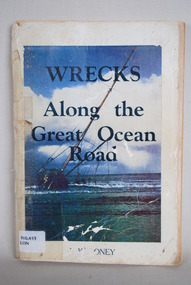
Book, J Loney, Wrecks Along the Great Ocean Road, 1967
... Anglesea and District Historical Society 5B McMillan Street Anglesea great-ocean-road jack loney dewey no 910.453 book Title: WRECKS / Along the / Great Ocean / Road J.K. LONEY Book first published in 1967 dealing with the shipwrecks along the Great Ocean Road. Illustrated with both maps ...Book first published in 1967 dealing with the shipwrecks along the Great Ocean Road. Illustrated with both maps and photographs and with a chrononolgy of the list of wrecks from pre-1800 through to 1958.Title: WRECKS / Along the / Great Ocean / Road J.K. LONEYjack loney, dewey no 910.453, book -
 Anglesea and District Historical Society
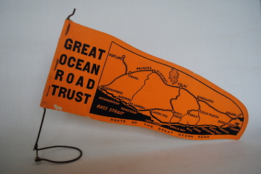
Pennant, Unknown
... Anglesea and District Historical Society 5B McMillan Street Anglesea great-ocean-road great ocean road trust GREAT/ OCEAN/ ROAD/ TRUST. Map of Area/ Route of the Great Ocean. ...Orange pennant flag listing towns on and near the Great Ocean Road. List of town names on pennant - (west to east) Mortlake, Warrnambool, Nirranda, Terang, Port Campbell, Lavers Hill, Colac, Beech Forest, Apollo Bay, Wye, Birregurra, Forrest, Deans Marsh, Peterborough, Princetown, Lorne, Eastern View, Airy's Inlet, Anglesea, Torquay, Geelong, Barwon Heads.GREAT/ OCEAN/ ROAD/ TRUST. Map of Area/ Route of the Great Ocean. (Orange - on wire stand. Printed on both sides.) great ocean road trust -
 Anglesea and District Historical Society
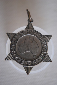
Medal Commemorative Australian Federation, 1898
... Anglesea and District Historical Society 5B McMillan Street Anglesea great-ocean-road Ref/ Car. 1898/2. medal commemorative australian federation Map of Australia within ring. ...Ref/ Car. 1898/2. Star shapped medal issued in 1898 tocommemorate the forthcoming Commonweath of Australia - a map of Australia in the centre divided into six states/colonies, each state represented by a ray - inscribed around the circumferance and with provision for a pin to be attached with hole and metal ring on the top ray of star. Back of medal perfectly plain.Map of Australia within ring. Around ring: "AUSTRALIA'S COMMONWEALTH" *3.6.98*medal, commemorative, australian federation -
 Anglesea and District Historical Society
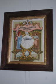
Framed Certificate, Australian Natives' Association, Estimated 1947
... Anglesea great-ocean-road australian natives' association j.w. read Certificate reads: Branch No 311 / EX PRESIDENT'S / CERTIFICATE / This is to certify that / J.W. Read / occupied the position of President of / this branch from 20.11.45 / to 25.2.47 / faded signature of President / faded signature of Secretary. Ex-president's Certificate from the Australian Natives' Association with details of recipient's details in central circle - an Australian emblem on the top - female figure on one side of circle holding flag in one hand and male figure on other side / symbolising bushman? Smaller circle underneath encloses star with map ...Ex-president's Certificate from the Australian Natives' Association with details of recipient's details in central circle - an Australian emblem on the top - female figure on one side of circle holding flag in one hand and male figure on other side / symbolising bushman? Smaller circle underneath encloses star with map of Australia in centre and six state emblems in points. Scenes either side depict native Australian first fleet and Canberra Parliament House. All decorated with wattle and in a wooden frame.Certificate reads: Branch No 311 / EX PRESIDENT'S / CERTIFICATE / This is to certify that / J.W. Read / occupied the position of President of / this branch from 20.11.45 / to 25.2.47 / faded signature of President / faded signature of Secretary. australian natives' association, j.w. read -
 Anglesea and District Historical Society
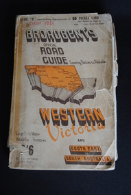
Road Directory, Broadbent's Official Road Guides Company, Broadbent's Official Road Guide Western Victoria, 1956
... Anglesea and District Historical Society 5B McMillan Street Anglesea great-ocean-road Maps Advertisements Broadbent Circa 1956 Contains maps and advertisements for Western Victoria in 1956 as well as some of South-East of South Australia. 240 pages. ...Contains maps and advertisements for Western Victoria in 1956 as well as some of South-East of South Australia. 240 pages. Fold out maps included.Circa 1956maps, advertisements, broadbent -
 Ballarat Tramway Museum
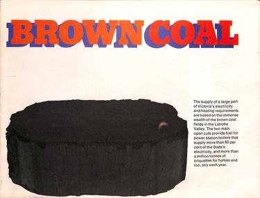
Poster, State Electricity Commission of Victoria (SECV), "Brown Coal", mid 1970s
... Has many photographs of the dredging of the coal, processing and includes a map of this type of coal in Victoria, including Bacchus Marsh and Anglesea....Has many photographs of the dredging of the coal, processing and includes a map of this type of coal in Victoria, including Bacchus Marsh and Anglesea. Demonstrates an item used by the SECV to distribute public relations materials. ...Poster prepared by the SECV to provide information about Brown Coal, the source of most of the Victorian electricity at the time and prior to it becoming a "dirty environmental, green house gas" product. Has many photographs of the dredging of the coal, processing and includes a map of this type of coal in Victoria, including Bacchus Marsh and Anglesea.Demonstrates an item used by the SECV to distribute public relations materials. Has a close association with the organisation that ran Ballarat's trams from 1934 to 1971.Poster - 8 fold, printed in colour.secv, publicity, public relations, power stations, power generation, latrobe valley