Showing 13 items matching "anticline folds"
-
 Bendigo Historical Society Inc.
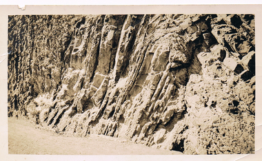
Photograph - MCCOLL, RANKIN AND STANISTREET COLLECTION: ANTICLINE FOLD, 1930
... MCCOLL, RANKIN AND STANISTREET COLLECTION: ANTICLINE FOLD......Anticline folds...Black and white photo. Anticline folds from a road cutting in Studley Park, Melbourne.Snap by SEC 1930....Photograph MCCOLL, RANKIN AND STANISTREET COLLECTION: ANTICLINE FOLD ...Photograph. Black and white photo. Anticline folds from a road cutting in Studley Park, Melbourne.Snap by SEC 1930.photograph, landscape, anticline folds -
 Bendigo Historical Society Inc.
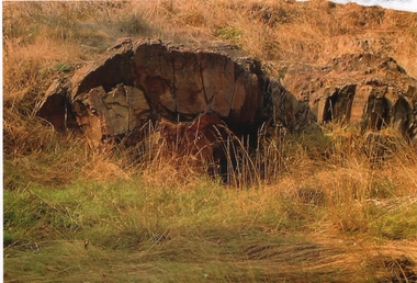
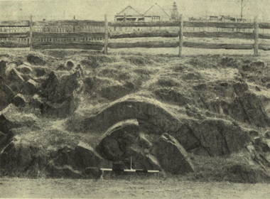
Photograph - ANTICLINE FOLD ROCK FORMATION - BENDIGO CREEK
... ANTICLINE FOLD ROCK FORMATION - BENDIGO CREEK......Anticline folds...Colour photograph of an anticline fold rock formation - Bendigo Creek possibly in Golden Square. ...History House 11 Mackenzie Street Bendigo goldfields PHOTOGRAPH Landscape Anticline folds Colour photograph of an anticline fold rock formation - Bendigo Creek possibly in Golden Square. ...Colour photograph of an anticline fold rock formation - Bendigo Creek possibly in Golden Square. An anticline is a structural trap formed by the folding of rock strata into an arch-like shape. The rock layers in an anticlinal trap were originally laid down horizontally and then earth movement caused it to fold into an arch-like shape called an anticline.photograph, landscape, anticline folds -
 Ballarat Heritage Services
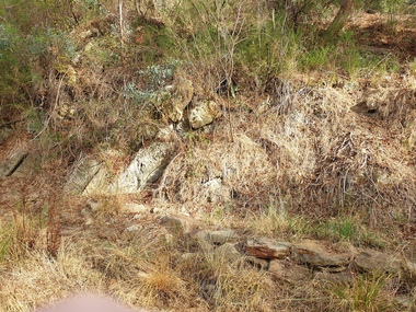
Photograph - Photograph - Colour, Anticline in the Hepburn Springs Reserve, 2019, 22/04/2019
... Anticlines are folded rock formations that have an upwards convex shape. ...Ballarat Heritage Services PO Box 2209 Bakery Hill Post Office goldfields Anticlines are folded rock formations that have an upwards convex shape. ...Anticlines are folded rock formations that have an upwards convex shape. Anticlines can exist as a single fold or as a series of adjacent folds of alternating synclines and anticlines. The Hepburn Springs anticline is geologically associated with the west dipping fissures cutting across sandstone strata of the Hepburn Spring anticline.Colour photograph of an anticline at Hepburn Mineral Springs Reserve, in close proximity to the Sulphur Spring. hepburn springs, anticline, geology, hepburn mineral springs reserve, hepburn anticline, hepburn geology -
 Bendigo Historical Society Inc.
Document - History Notes - Information on Mining, statistics and early development of Bendigo, 1840-1990 approx
... Saddle, Fault, and Spur reefs are the main types, found in Ordovician slates and sandstones folded into anticlines and synclines. Major Productive Reefs: Hustlers, Garden Gully, Paddy's Gully, Sheepshead, New Chum, Nell Gwynne, and Carshalton.Mining Process: Gold is found in quartz lodes, extracted, crushed, and separated using mercury amalgamation. ...Saddle, Fault, and Spur reefs are the main types, found in Ordovician slates and sandstones folded into anticlines and synclines. Major Productive Reefs: Hustlers, Garden Gully, Paddy's Gully, Sheepshead, New Chum, Nell Gwynne, and Carshalton.Mining Process: Gold is found in quartz lodes, extracted, crushed, and separated using mercury amalgamation. ...Saddle, Fault, and Spur reefs are the main types, found in Ordovician slates and sandstones folded into anticlines and synclines. Major Productive Reefs: Hustlers, Garden Gully, Paddy's Gully, Sheepshead, New Chum, Nell Gwynne, and Carshalton.Mining Process: Gold is found in quartz lodes, extracted, crushed, and separated using mercury amalgamation. From 1851–1949, over 21 million ounces of gold were produced, valued at approximately £323 million (1964 prices). Located Bendigo is in central Victoria, north of the Dividing Range, between Campaspe Valley and Loddon flats; 100 miles from Melbourne. The City area is 8,030 acres; population around 40,000 (city), 47,000 (district).Climate is temperate, with average rainfall of 20 inches, and 320 sunny days per year. Gold First discovered in 1851 at Golden Square. Bendigo Became a municipal district in 1855, a town in 1861, a city in 1871, and changed its name from Sandhurst to Bendigo in 1891. Key Events: Establishment of hospital, police court, churches, schools, and infrastructure like railways and water supply.Governance and Civic Structure. Council Structure: 3 wards, each with 3 councillors serving 3-year terms; mayor elected by councillors. Main revenue from rates and property; principal duties include public works, health, parks, and enforcement of by-laws. Major Projects: Olympic swimming pool, market extensions, park improvements, road and drainage works.Economy and IndustryCommerce: 730 retail shops, 260 factories, and a major livestock market.Principal Industries: Meat processing, manufacturing (including ordnance, textiles, engineering), fruit and food processing, and egg production. Bendigo is Noted for sheep, lamb, fruit (especially tomatoes and apples), and dairy. Major rail and road hub with connections across Victoria and to New South Wales; tram and bus services.Education: Institute of Technology, Teachers College, multiple secondary and primary schools, and special education facilities. Several hospitals, aged care homes, and health services. 486 acres of parks and gardens, extensive sports facilities, and Lake Eppalock for water sports. Wide range of community, cultural, and sporting organizations. Regional library, art gallery, music and drama societies. Notable Figures and HeritageGeorge Lansell: Known as the "Gold King," a key figure in Bendigo's mining history. Transformation: From a sheep run to a major goldfield and then to a modern city with significant infrastructure and cultural assets. Motto Coat of Arms: Features symbols representing gold mining, agriculture, pioneering, and fruit growing.Motto: "Progress" in gold on a purple ribbon.Bendigo's history is marked by rapid growth from gold discovery, strong civic development, and a diverse economy, making it a significant regional center in Victoria.History Notes - Information on Mining, statistics and early development of Bendigo - author unknown This item contains the following document: 11217.65a Twelve Foolscap typed pages with information on Bendigonon-fictionbendigo, fortuna, george lansell, development of bendigo -
 Bendigo Historical Society Inc.
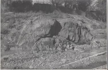
Photograph - Napoleon Anticline, 1935
... In structural geology, an anticline is a type of fold that is an arch-like shape and has its oldest beds at its core, whereas a syncline is the inverse of an anticline. ...A typical anticline is convex up in which the hinge or crest is the location where the curvature is greatest, and the limbs are the sides of the fold that dip away from the hinge. ...In structural geology, an anticline is a type of fold that is an arch-like shape and has its oldest beds at its core, whereas a syncline is the inverse of an anticline. A typical anticline is convex up in which the hinge or crest is the location where the curvature is greatest, and the limbs are the sides of the fold that dip away from the hinge.Significant to mining history of Bendigo.Black and white photograph: rock formation, anticline with an archlike shape in centre of image. Written in pencil on back of photograph : 'Napoleon anticline Golden Square'.napoleon gold mine, anticline -
 Ballarat Heritage Services
Photograph - Image, Anticlinal Fold, Lyttleton Street, Castlemaine, c1880, c1880
... Saddle reefs occur in similar folds of the sandstones and slates on lower geological horizons." anticlinal fold geology castlemaine An anticline at Castlemaine, Victoria. ...In 1927 a plaque was installed at this anticlinal fold. Since no plaque is evident in the photo the date would be pre1927. The plaque states "This fine exhibit was disclosed when Lyttleton Street East was constructed in 1874. Saddle reefs occur in similar folds of the sandstones and slates on lower geological horizons." An anticline at Castlemaine, Victoria. This natural feature was uncovered during Lyttleton Street roadworks in 1880. anticlinal fold, geology, castlemaine -
 Bendigo Historical Society Inc.
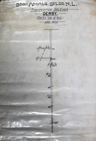
Map - Derby Line of Reef, Unknown
... The Derby Anticline penetrates the area from its north boundary for a distance ofabout 30 chains at which point the fold disappears southwards. ...The Derby Anticline penetrates the area from its north boundary for a distance ofabout 30 chains at which point the fold disappears southwards. ...Informit: Lease application no.11038 contains a length of about 48 chains of the Paddy's Gully line of reefs. The Derby Anticline penetrates the area from its north boundary for a distance ofabout 30 chains at which point the fold disappears southwards. The outcrop of the Paddy's Gully Anticline is exposed in McClure Street. Along this section of the Paddys Gully line the top of what is regarded as 'favorable beds' occurs about 150 feet from the surface. It is estimated that the containing beds of Ladam's reef and the Garden Gully 300 feet reef, both of which proved to have been rich ore bodies on the Garden Gully line adjoining on the west, will be found at the approximate depth of 550 feet onthe Paddy's Gully line near the intersection of McClure and Bannerman Streets. A shorter vertical point of attack, though the position is less favorable geologically, is kocks Pioneer east shaft which is 420 feet deep. A crosscut east from this shaft ata depth of 200 feet reaches the Derby Line in a distance of 700 feet. (https://search.informit.org/doi/10.3316/aesis.200104712) Printed in black text on top of plan: 'Bgo Amalg Gflds N.L." (Bendigo Amalgamated Goldfields N.L.) Transverse Section, Derby, Derby Line of Reef. Scale 100' = 1". Plan forms part of the Margaret Roberts Collection.gold mining, gold, bendigo, derby, derby line of reef, transverse section -
 Bendigo Historical Society Inc.
Newspaper - Kangaroo Flat Gold Mine Collection: Gold search continues, 2.9.2000
... folded, interbedded sandstone and shale sediments. Within the sediments the gold mineralisation is hosted in quartz reefs or ribbons closely associated with anticline axes and reverse faulting. ...folded, interbedded sandstone and shale sediments. Within the sediments the gold mineralisation is hosted in quartz reefs or ribbons closely associated with anticline axes and reverse faulting. ...New Bendigo Gold Project The Bendigo goldfield is centred on the urban area of Bendigo (population approximately 60 000) in central Victoria, 130 km north west of Melbourne, Australia. Gold was discovered at Bendigo in 1851 and production continued through to 1954. The Bendigo goldfield is the second largest goldfield in total gold produced in Australia, after Kalgoorlie's Golden Mile with a total production of 22 million oz. The geology of the Bendigo Field consists of a series of tightly folded, interbedded sandstone and shale sediments. Within the sediments the gold mineralisation is hosted in quartz reefs or ribbons closely associated with anticline axes and reverse faulting. The gold within the quartz reefs is typically both coarse grained and erratically distributed.Bendigo Advertiser article attached to a photocopy of an underground rock formation. Photocopy date stamped 21.8.2000. Headline on newspaper article: 'Gold search continues'. Content describes exploration on the New Chum line of reef 'down to 1500 metres below the surface'. Doug Buerger is quoted discussing the 10 million ounce potential of the New Bendigo gold project. The Garden Gully line of reef is being tested for unmined ribbons on the reefline. bendigo mining n.l., bendigo, mining, gold, kangaroo flat, doug buerger, garden gully reef, new chum reef -
 Bendigo Historical Society Inc.
Newspaper - Kangaroo Flat Gold Mine Collection: New Bendigo Gold Project
... folded, interbedded sandstone and shale sediments. Within the sediments the gold mineralisation is hosted in quartz reefs or ribbons closely associated with anticline axes and reverse faulting. ...folded, interbedded sandstone and shale sediments. Within the sediments the gold mineralisation is hosted in quartz reefs or ribbons closely associated with anticline axes and reverse faulting. ...New Bendigo Gold Project The Bendigo goldfield is centred on the urban area of Bendigo (population approximately 60 000) in central Victoria, 130 km north west of Melbourne, Australia. Gold was discovered at Bendigo in 1851 and production continued through to 1954. The Bendigo goldfield is the second largest goldfield in total gold produced in Australia, after Kalgoorlie's Golden Mile with a total production of 22 million oz. The geology of the Bendigo Field consists of a series of tightly folded, interbedded sandstone and shale sediments. Within the sediments the gold mineralisation is hosted in quartz reefs or ribbons closely associated with anticline axes and reverse faulting. The gold within the quartz reefs is typically both coarse grained and erratically distributed.'Harmony puts up $50m for Bendigo start'. Newspaper article details the 'stunning coup' that Bendigo Mining has organised to secure a minimum $50m cash injection from South Africa's Harmony to 'return to production at its historic Bendigo goldfield after a 50 year lay-off'. Mr. Doug Buerger, managing Director of Bendigo Mining, stated that the New Bendigo project has 'the potential to become a very profitable, large-scale gold producer'. 'The Age' attributed at end of article. In pencil on top of article: 'West Australian 26/9/2004'bendigo mining n.l., bendigo, mining, gold, kangaroo flat, harmony, south africa, mining shares, doug buerger -
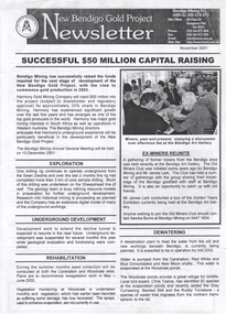
 Bendigo Historical Society Inc.
Document - Kangaroo Flat Gold Mine Collection: New Bendigo Gold Project, 2.9.2000
... folded, interbedded sandstone and shale sediments. Within the sediments the gold mineralisation is hosted in quartz reefs or ribbons closely associated with anticline axes and reverse faulting. ...folded, interbedded sandstone and shale sediments. Within the sediments the gold mineralisation is hosted in quartz reefs or ribbons closely associated with anticline axes and reverse faulting. ...New Bendigo Gold Project The Bendigo goldfield is centred on the urban area of Bendigo (population approximately 60 000) in central Victoria, 130 km north west of Melbourne, Australia. Gold was discovered at Bendigo in 1851 and production continued through to 1954. The Bendigo goldfield is the second largest goldfield in total gold produced in Australia, after Kalgoorlie's Golden Mile with a total production of 22 million oz. The geology of the Bendigo Field consists of a series of tightly folded, interbedded sandstone and shale sediments. Within the sediments the gold mineralisation is hosted in quartz reefs or ribbons closely associated with anticline axes and reverse faulting. The gold within the quartz reefs is typically both coarse grained and erratically distributed.Two page document produced by Bendigo Mining N.L. on the occasion of their 2002 Open Day. Front page 'Welcome to the New Bendigo Giold Project' outlines the procedure involved in signing in and safety issues whilst on site. A site plan is provided. Second page is an information sheet, and provides facts and figures on the project to date. bendigo mining n.l., bendigo, mining, gold, kangaroo flat, 2002, new bendigo gold project, open day -
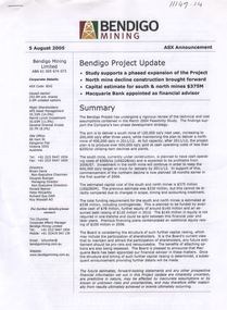
 Bendigo Historical Society Inc.
Letter - Kangaroo Flat Gold Mine Collection: Ralph Birrell, 3rd November, 1998
... folded, interbedded sandstone and shale sediments. Within the sediments the gold mineralisation is hosted in quartz reefs or ribbons closely associated with anticline axes and reverse faulting. ...folded, interbedded sandstone and shale sediments. Within the sediments the gold mineralisation is hosted in quartz reefs or ribbons closely associated with anticline axes and reverse faulting. ...Dr Ralph Birrell (20/3/1927 - 7/6/2014) was a lecturer at the Bendigo School of mines and the author of numerous books about mining in Victoria, particularly Bendigo, and books on various elements of Bendigo history. New Bendigo Gold Project The Bendigo goldfield is centred on the urban area of Bendigo (population approximately 60 000) in central Victoria, 130 km north west of Melbourne, Australia. Gold was discovered at Bendigo in 1851 and production continued through to 1954. The Bendigo goldfield is the second largest goldfield in total gold produced in Australia, after Kalgoorlie's Golden Mile with a total production of 22 million oz. The geology of the Bendigo Field consists of a series of tightly folded, interbedded sandstone and shale sediments. Within the sediments the gold mineralisation is hosted in quartz reefs or ribbons closely associated with anticline axes and reverse faulting. The gold within the quartz reefs is typically both coarse grained and erratically distributed.Three letters from Bendigo Mining N.L. 14th May 1998, 3 November 1998, and 22nd. April 1999, to Mr. Ralph Birrell from Bendigo Mining N.L. regarding the next meeting of the old miners club to be held at Bendigo mining's site offices. Signed by Shelley Saunders, Community Affairs Co-ordinator. On bottom of page: Registered and Secretarial Office, 61-65 Bull Street, Bendigo Vic 3550. Carshalton Site Office, Coonooer Street, Kangaroo Flat, Vic 3555.bendigo mining n.l., bendigo, mining, gold, kangaroo flat, ralph birrell, old miners group -
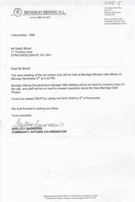
 Bendigo Historical Society Inc.
Document - Kangaroo Flat Gold Mine Collection: Bendigo Project Update ASX announcement, Bendigo Mining NL, 5 August 2005
... folded, interbedded sandstone and shale sediments. Within the sediments the gold mineralisation is hosted in quartz reefs or ribbons closely associated with anticline axes and reverse faulting. ...folded, interbedded sandstone and shale sediments. Within the sediments the gold mineralisation is hosted in quartz reefs or ribbons closely associated with anticline axes and reverse faulting. ...New Bendigo Gold Project The Bendigo goldfield is centred on the urban area of Bendigo (population approximately 60 000) in central Victoria, 130 km north west of Melbourne, Australia. Gold was discovered at Bendigo in 1851 and production continued through to 1954. The Bendigo goldfield is the second largest goldfield in total gold produced in Australia, after Kalgoorlie's Golden Mile with a total production of 22 million oz. The geology of the Bendigo Field consists of a series of tightly folded, interbedded sandstone and shale sediments. Within the sediments the gold mineralisation is hosted in quartz reefs or ribbons closely associated with anticline axes and reverse faulting. The gold within the quartz reefs is typically both coarse grained and erratically distributed. Source: https://www.ausimm.com/publications/conference-proceedings/eighth-underground-operators-conference-2002/new-bendigo-gold-project/Three page, double sided project update for the Bendigo project. On top of front page 'Bendigo Mining, 5 August 2005, ASX Announcement'. Content includes: summary of the project with the aim defined 'to deliver a south mine of 120,000 oz/y next year, increasing to 200,000 oz/y in 2011/12. At full capacity, after 2001/12, the project plan is to produce over 600,000 oz/y gold at cash operating costs of less than $200/0z utilising twin declines and plants'. Development strategy, funding, recent expenditures, key project details, production, processing, operating costs, development capital, maintenance capital are discussed in the project update. bendigo mining n.l., bendigo, mining, gold, kangaroo flat, swan decline, development strategy, funding, recent expenditures, key project details, production, processing, oeprating costs, development capital, maintenance capital, stock exchange, project update -
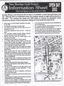
 Bendigo Historical Society Inc.
Document - Kangaroo Flat Gold Mine Collection: Bendigo Gold Project Newsletters, Bendigo Mining NL, November 2001, August 2002, October 2002, July 2005, February 2006 and May 2006
... folded, interbedded sandstone and shale sediments. Within the sediments the gold mineralisation is hosted in quartz reefs or ribbons closely associated with anticline axes and reverse faulting. ...folded, interbedded sandstone and shale sediments. Within the sediments the gold mineralisation is hosted in quartz reefs or ribbons closely associated with anticline axes and reverse faulting. ...New Bendigo Gold Project The Bendigo goldfield is centred on the urban area of Bendigo (population approximately 60 000) in central Victoria, 130 km north west of Melbourne, Australia. Gold was discovered at Bendigo in 1851 and production continued through to 1954. The Bendigo goldfield is the second largest goldfield in total gold produced in Australia, after Kalgoorlie's Golden Mile with a total production of 22 million oz. The geology of the Bendigo Field consists of a series of tightly folded, interbedded sandstone and shale sediments. Within the sediments the gold mineralisation is hosted in quartz reefs or ribbons closely associated with anticline axes and reverse faulting. The gold within the quartz reefs is typically both coarse grained and erratically distributed. Source: https://www.ausimm.com/publications/conference-proceedings/eighth-underground-operators-conference-2002/new-bendigo-gold-project/Six newsletters, "New Bendigo Gold Project", dated November 2001, August 2002, October 2002, July 2005, February 2006 and May 2006. Newsletters highlight development of gold project; a map of the decline development, underground workings and personnel news is featured on most newsletters. bendigo mining n.l., bendigo, mining, gold, kangaroo flat, decline, swan decline, south decline, new moon plant eaglehawk, ventilation shaft, drilling, blasting, ground support, sandra burns, james lerk, underground development, rehabilitation, greg miller, alexandria reef