Showing 299 items matching "aqueduct"
-
 Stawell Historical Society Inc
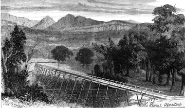
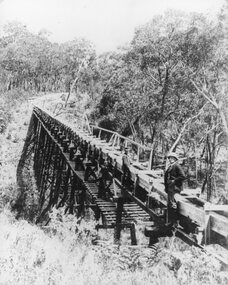
Drawing, Stawell Water Supply Bovine Aqueduct 1881 -- Sketch
... Stawell Water Supply Bovine Aqueduct 1881 -- Sketch...Sketches of Stawell Water Supply Bovine Aqueduct October 5th 1881. The Grampian scheme planned by the the Borough Engineer John D'Alton. ...The Bovine Aqueduct ...Stawell Water Supply Bovine Aqueduct 1881 -- Sketch Drawing ...Sketches of Stawell Water Supply Bovine Aqueduct October 5th 1881. The Grampian scheme planned by the the Borough Engineer John D'Alton. D'Alton's suggestion was that the water be carried from the source in an open channel two miles, then in a flume of timber. Later surveyed and planned a tunnel on a good line - to reduce the flume 72 miles and the main to Stawell to 15 miles. This sketch (illustrated Australian News October 5, 1881).Black and white photograph of a sketch a bush scene with mountains in background. The sketch depicts a trestle bridge construction. The Bovine Aqueduct stawell water supply -
 Eltham District Historical Society Inc
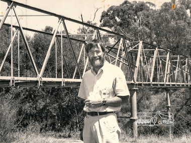
Photograph, Christine Fleming, Russell Yeoman near the Maroondah Aqueduct, Greensborough
... Russell Yeoman near the Maroondah Aqueduct, Greensborough...Black and white photograph of Russell Yeoman, of Eltham District Historical Society near the Maroondah Aqueduct, Greensborough. Photograph was published in the Diamond Valley News, unknown date...ME34DV712 Reduction: 88.7% Caption: Man beside aqueduct Photographers' Caption Sheet Date:13-2 Publication: DV Operator's Name: Christine Fleming Assignemnt: Maroondah Aqueduct Greensborough Names and Initials: Russell Yeomans (sic)...ME34DV712 Reduction: 88.7% Caption: Man beside aqueduct Photographers' Caption Sheet Date:13-2 Publication: DV Operator's Name: Christine Fleming Assignemnt: Maroondah Aqueduct Greensborough Names and Initials: Russell Yeomans (sic) Black and white photograph of Russell Yeoman, of Eltham District Historical Society near the Maroondah Aqueduct, Greensborough. ...Black and white photograph of Russell Yeoman, of Eltham District Historical Society near the Maroondah Aqueduct, Greensborough. Photograph was published in the Diamond Valley News, unknown dateTwo paper labels stuck to rear Publication: DV (Diamond Valley News) Page No: 4 ID No. ME34DV712 Reduction: 88.7% Caption: Man beside aqueduct Photographers' Caption Sheet Date:13-2 Publication: DV Operator's Name: Christine Fleming Assignemnt: Maroondah Aqueduct Greensborough Names and Initials: Russell Yeomans (sic)russell yeoman, maroondah aqueduct, greensborough -
 Greensborough Historical Society
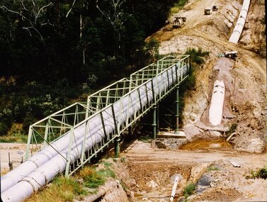
Photograph - Digital image, New pipeline replacing Watts Reservoir aqueduct, 1977_
... New pipeline replacing Watts Reservoir aqueduct...aqueduct...Photograph of new aqueduct pipe near Plenty River Greensborough....Greensborough Historical Society 34A Glenauburn Road Lower Plenty Lower Plenty melbourne Photograph of new aqueduct pipe near Plenty River Greensborough. aqueduct maroondah aqueduct plenty river Digital copy of colour photograph. ...Photograph of new aqueduct pipe near Plenty River Greensborough.Digital copy of colour photograph.aqueduct, maroondah aqueduct, plenty river -
 Greensborough Historical Society
Photograph - Digital Image, Pipes over Plenty, construction of original bridge for Watts Reservoir aqueduct, 1950-1970
... Pipes over Plenty, construction of original bridge for Watts Reservoir aqueduct.......aqueduct...Photograph of the Maroondah aqueduct bridge over the Plenty River in Greensborough....Greensborough Historical Society 34A Glenauburn Road Lower Plenty Lower Plenty melbourne Photograph of the Maroondah aqueduct bridge over the Plenty River in Greensborough. maroondah aqueduct aqueduct plenty river Digital copy of black and white photograph. ...Photograph of the Maroondah aqueduct bridge over the Plenty River in Greensborough.Digital copy of black and white photograph.maroondah aqueduct, aqueduct, plenty river -
 Eltham District Historical Society Inc
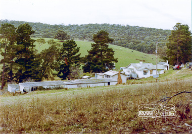
Photograph, Aqueduct, Research
... Aqueduct, Research...Colour photograph from aqueduct showing old poultry farm, Research...Eltham District Historical Society Inc 728 Main Rd Eltham melbourne research maroondah aqueduct farms poultry main road Colour photograph from aqueduct showing old poultry farm, Research Aqueduct, Research Photograph ...Colour photograph from aqueduct showing old poultry farm, Researchresearch, maroondah aqueduct, farms, poultry, main road -
 Eltham District Historical Society Inc
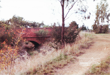
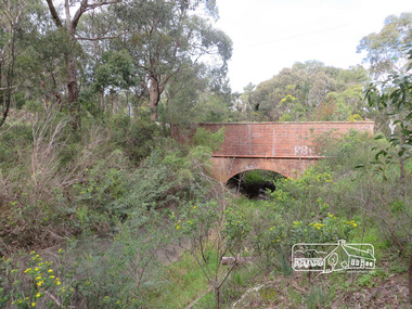
Photograph, Parsons Road bridge over former Maroondah Aqueduct
... Parsons Road bridge over former Maroondah Aqueduct...Colour photograph of Parsons Road bridge over disused Maroondah Aqueduct...Eltham District Historical Society Inc 728 Main Rd Eltham melbourne parsons road eltham north research aqueducts maroondah aqueduct bridges Colour photograph of Parsons Road bridge over disused Maroondah Aqueduct Parsons Road bridge over former Maroondah Aqueduct Photograph ...Colour photograph of Parsons Road bridge over disused Maroondah Aqueductparsons road, eltham north, research, aqueducts, maroondah aqueduct, bridges -
 Eltham District Historical Society Inc
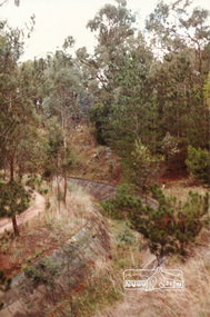
Photograph, Russell Yeoman, Maroondah Aqueduct, Research, c.1990
... Maroondah Aqueduct, Research...Colour photograph of abandoned aqueduct near Afton Street, Research c.1990...maroondah aqueduct aqueducts Colour photograph of abandoned aqueduct near Afton Street, Research c.1990 Maroondah Aqueduct, Research Photograph Russell Yeoman ...Colour photograph of abandoned aqueduct near Afton Street, Research c.1990maroondah aqueduct, aqueducts -
 Eltham District Historical Society Inc
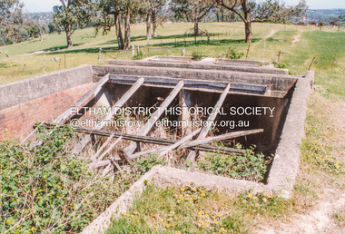
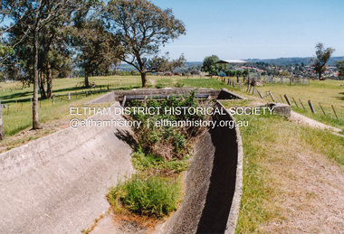
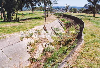
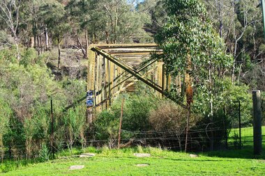
Photograph, Maroondah Aqueduct north of Allendale Road, Eltham North
... Maroondah Aqueduct north of Allendale Road, Eltham North...Four colour photographs of abandoned Maroondah Aqueduct north of Allendale Road, Eltham North...Eltham District Historical Society Inc 728 Main Rd Eltham melbourne aqueducts maroondah aqueduct allendale road eltham north Four colour photographs of abandoned Maroondah Aqueduct north of Allendale Road, Eltham North Maroondah Aqueduct north of Allendale Road, Eltham North Photograph Photograph ...Four colour photographs of abandoned Maroondah Aqueduct north of Allendale Road, Eltham Northaqueducts, maroondah aqueduct, allendale road, eltham north -
 Eltham District Historical Society Inc
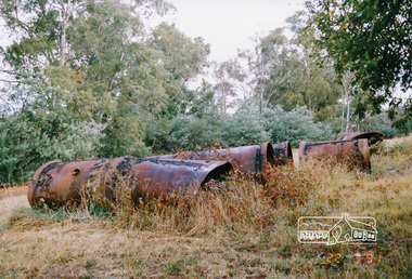
Photograph, Old aqueduct pipes, Allendale Road, Eltham, March 1991, 1991
... Old aqueduct pipes, Allendale Road, Eltham, March 1991...Colour photograph of old aqueduct pipes near Diamond Creek crossing, Allendale Road, Eltham...Eltham District Historical Society Inc 728 Main Rd Eltham melbourne maroondah aqueduct allendale road diamond creek eltham eltham north Colour photograph of old aqueduct pipes near Diamond Creek crossing, Allendale Road, Eltham Old aqueduct pipes, Allendale Road, Eltham, March 1991 Photograph ...Colour photograph of old aqueduct pipes near Diamond Creek crossing, Allendale Road, Elthammaroondah aqueduct, allendale road, diamond creek, eltham, eltham north -
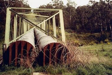
 Greensborough Historical Society
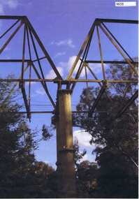
Photograph, Maroondah aqueduct pipe bridge 2011, 2011_
... Maroondah aqueduct pipe bridge 2011...It supplied water to Melbourne, via the Maroondah aqueduct. The Maroondah Reservoir, northeast of Melbourne, was completed in 1927 and water was piped via the Maroondah aqueduct to the northern suburbs. ...It was replaced by large pipes in the 1980s. Parts of the aqueduct structure remain. aqueduct pipe bridge greensborough maroondah aqueduct Copy of colour photograph Maroondah aqueduct pipe bridge 2011 Photograph ...in 1891 the Watts River (near Healesville) was tapped. It supplied water to Melbourne, via the Maroondah aqueduct. The Maroondah Reservoir, northeast of Melbourne, was completed in 1927 and water was piped via the Maroondah aqueduct to the northern suburbs. It was replaced by large pipes in the 1980s. Parts of the aqueduct structure remain.Copy of colour photographaqueduct pipe bridge greensborough, maroondah aqueduct -
 Eltham District Historical Society Inc
Slide, Maroondah Aqueduct, Research, Victoria, 22 Mar. 1981
... Maroondah Aqueduct, Research, Victoria...An inspection tour of the Maroondah Aqueduct was undertaken by the Shire of Eltham Historical Society on Sunday, March 22nd, 1981, commening where the aqueduct crosses Main Rd., Research, just below Eltham College. ...Eltham District Historical Society Inc 728 Main Rd Eltham melbourne An inspection tour of the Maroondah Aqueduct was undertaken by the Shire of Eltham Historical Society on Sunday, March 22nd, 1981, commening where the aqueduct crosses Main Rd., Research, just below Eltham College. ...An inspection tour of the Maroondah Aqueduct was undertaken by the Shire of Eltham Historical Society on Sunday, March 22nd, 1981, commening where the aqueduct crosses Main Rd., Research, just below Eltham College. The Maroondah Aqueduct was part of Melbourne’s water supply system. It carried water over the 66 km from the Maroondah Reservoir on the Watts River at Healesville to the Preston Reservoir. Of this length, 41 km were open channel, 10 km, tunnel through hills and 15 km in 14 inverted siphons across stream valleys. The route of the aqueduct is north of Tarrawarra and Yarra Glen, along the Yarra escarpment south of Christmas Hills and crossing Watsons Creek into the present Shire of Eltham near Henley Rd. The eastern part of the route lies entirely within the former boundaries of the shire. The aqueduct passes south of Kangaroo Ground to Research and crosses the Diamond Creek by siphon at Allendale Rd., Eltham North. It then extends to Reservoir via St. Helena, Greensborough North and Bundoora. Water first flowed through the aqueduct in February 1891 when it was fed by a diversion weir on the Watts River. Records of the building of the aqueduct indicate that it was a significant construction achievement. The present Maroondah Reservoir was completed in 1927 and the aqueduct was enlarged at that time to take increased flows. About 1971 the section of the aqueduct through and north of Research was replaced by a large pipe and that section of the channel is now unused. The channel has remained largely intact (unlike sections at Greensborough and Bundoora where long lengths of the disused aqueduct have been demolished or filled in). The M.M.B.W. relinquished control of the disused aqueduct reserve which is crown land and the Shire of Eltham took control of this section of the reserve as a linear park. The Maroondah Aqueduct is considered to be an important historic structure, not just to the local area but to the metropolitan area generally. It is considered important to preserve substantially intact long lengths of the disused aqueduct, together with its bridges and other associated structures. 35 mm colour positive transparency (1 of 5) Mount - Agfachrome Agfa CS System black 8 dotsactivities, heritage excursion, maroondah aqueduct, research (vic.), shire of eltham historical society -
 Eltham District Historical Society Inc
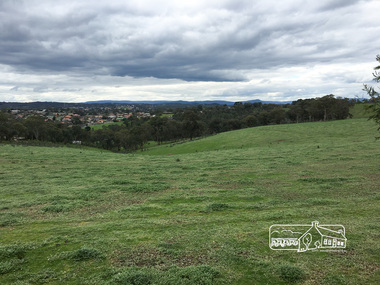
Photograph, Peter Pidgeon, View to Diamond Creek from Maroondah Aqueduct Trail just east of Godber Road, Eltham North, 3 Sept 2016, 5 Mar 2016
... View to Diamond Creek from Maroondah Aqueduct Trail just east of Godber Road, Eltham North, 3 Sept 2016...Heritage Excursion - Maroondah Aqueduct ...Eltham District Historical Society Inc 728 Main Rd Eltham melbourne Heritage Excursion - Maroondah Aqueduct activities eltham district historical society heritage excursion maroondah aqueduct diamond creek godber road eltham north Born Digital View to Diamond Creek from Maroondah Aqueduct Trail just east of Godber Road, Eltham North, 3 Sept 2016 Photograph Peter Pidgeon ...Heritage Excursion - Maroondah Aqueduct Born Digitalactivities, eltham district historical society, heritage excursion, maroondah aqueduct, diamond creek, godber road, eltham north -
 Stawell Historical Society Inc
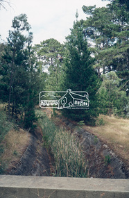
Photograph, Aqueduct in the Grampians for Stawell Water
... Aqueduct in the Grampians for Stawell Water...Aqueduct in Grampians for Stawell Water...Stawell Historical Society Inc 46 Longfield St Stawell grampians Aqueduct in Grampians for Stawell Water Stawell Aqueduct in the Grampians for Stawell Water Photograph ...Aqueduct in Grampians for Stawell Waterstawell -
 Eltham District Historical Society Inc
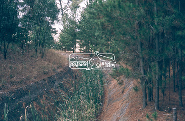
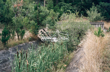
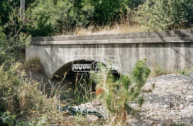
Photograph, Liz Pidgeon, Heritage Excursion; Maroondah Aqueduct, 3 September 2016, 3 September 2016
... Heritage Excursion; Maroondah Aqueduct, 3 September 2016... Heritage Excursion - Maroondah Aqueduct Walk - Saturday 3rd September The Maroondah Aqueduct was once a major link in Melbourne’s water supply system. ...Eltham District Historical Society Inc 728 Main Rd Eltham melbourne Heritage Excursion - Maroondah Aqueduct Walk - Saturday 3rd September The Maroondah Aqueduct was once a major link in Melbourne’s water supply system. ...Heritage Excursion - Maroondah Aqueduct Walk - Saturday 3rd September The Maroondah Aqueduct was once a major link in Melbourne’s water supply system. It was built between 1886 and 1891 to transfer water from the Watts River near Healesville to the Preston Reservoir. It was 66 km in length, made up of 41 km of open channel, 10 km of tunnel through hills and 15 km of pipeline across stream valleys known as inverted siphons. The section of the aqueduct through the Eltham area has been abandoned since the 1980s but the open channel has largely been retained. A recreational path follows the aqueduct reserve. For our excursion on 3rd September we intend to walk along the section of the aqueduct adjacent to Allendale Road. This is a section not visited on previous excursions and includes the transition from open channel to the inverted siphon across the Diamond Creek valley. Apart from the aqueduct itself the main feature of the walk is the extensive views across Eltham North and Diamond Creek. Along the way we will talk about the history of the aqueduct and the area. This easy walk is about 3 km return and will take 2 to 2.5 hours. It will start at 2pm at the junction of Allendale Road with Godber Road and Zig Zag Road North, officially Diamond Creek, but on the northern boundary of Eltham. (Melway ref.12 B10). Newsletter No., 229, August 2016 Brick bridge on Parsons road, Eltham North over the aqueduct on the aqueduct trail. Born Digitalmaroondah aqueduct, eltham north, activities, eltham district historical society, heritage excursion, parsons road, bridges, aqueduct trail -
 Greensborough Historical Society
Photograph - Photograph - Digital Image, Marilyn Smith, Aqueduct crossing the Plenty River, Greensborough 2019, 02/07/2019
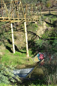
... Aqueduct crossing the Plenty River, Greensborough 2019...The aqueduct crossing the Plenty River, 2019, overgrown with vegetation. ...Greensborough Historical Society 34A Glenauburn Road Lower Plenty Lower Plenty melbourne The aqueduct crossing the Plenty River, 2019, overgrown with vegetation. ...The aqueduct crossing the Plenty River, 2019, overgrown with vegetation. Originally part of the Maroondah Aqueduct pipeline, all that remains is the bridge that once carried the pipe over the Plenty River. This photograph was taken from the Plenty River Trail in Greensborough. 3 colour digital photographsplenty river trail, maroondah pipetrack, maroondah aqueduct, plenty river, graffiti -
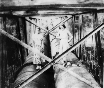 Greensborough Historical Society
Photograph - Digital image, Ladies on aqueduct, 1950c
... Ladies on aqueduct...Photograph of two ladies standing on the aqueduct pipes in Greensborough....Ladies on aqueduct Photograph - Digital image ...Photograph of two ladies standing on the aqueduct pipes in Greensborough.Digital copy of black and white photograph.aqueduct pipe bridge greensborough -
 Greensborough Historical Society
Slide - Photograph, John Ramsdale, Aqueduct from Yan Yean Reservoir: Slide 37, 1990s
... Aqueduct from Yan Yean Reservoir: Slide 37...Photograph shows the aqueduct from Yan Yean Reservoir...Greensborough Historical Society 34A Glenauburn Road Lower Plenty Lower Plenty melbourne Photograph shows the aqueduct from Yan Yean Reservoir Part of the John Ramsdale collection of slides and audio visual material. aqueducts yan yean reservoir No maker's marks. ...Photograph shows the aqueduct from Yan Yean ReservoirPart of the John Ramsdale collection of slides and audio visual material.Colour photograph scanned from slide.No maker's marks. No caption on slide.aqueducts, yan yean reservoir -
 Greensborough Historical Society
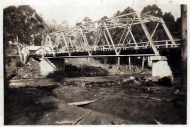
Photograph (copy), Aqueduct over the Plenty River / photographer unknown, 1920c
... Aqueduct over the Plenty River / photographer unknown...View of the Maroondah Aqueduct where it crosses the Plenty River in Greensborough....Greensborough Historical Society 34A Glenauburn Road Lower Plenty Lower Plenty melbourne View of the Maroondah Aqueduct where it crosses the Plenty River in Greensborough. maroondah aqueduct plenty river Black and white photograph, enlarged and laminated. ...View of the Maroondah Aqueduct where it crosses the Plenty River in Greensborough.Black and white photograph, enlarged and laminated.maroondah aqueduct, plenty river -
 Greensborough Historical Society
Photograph - Digital Image, Dual pipes: Aqueduct Greensborough, 2000c
... Dual pipes: Aqueduct Greensborough...Photograph of section of the Maroondah aqueduct over the Plenty River at Greensborough....Greensborough Historical Society 34A Glenauburn Road Lower Plenty Lower Plenty melbourne Photograph of section of the Maroondah aqueduct over the Plenty River at Greensborough. maroondah aqueduct aqueduct greensborough Digital copy of colour photograph. ...Photograph of section of the Maroondah aqueduct over the Plenty River at Greensborough.Digital copy of colour photograph.maroondah aqueduct, aqueduct greensborough -
 Greensborough Historical Society
Photograph - Digital Image, Marilyn Smith, Plenty River at the aqueduct crossing Greensborough 2019, 02/07/2019
... Plenty River at the aqueduct crossing Greensborough 2019...The Plenty River at the aqueduct crossing, 2019, showing graffiti on the river bank rocks. ...Greensborough Historical Society 34A Glenauburn Road Lower Plenty Lower Plenty melbourne The Plenty River at the aqueduct crossing, 2019, showing graffiti on the river bank rocks. ...The Plenty River at the aqueduct crossing, 2019, showing graffiti on the river bank rocks. Originally part of the Maroondah Aqueduct pipeline, all that remains is the bridge that once carried the pipe over the Plenty River. This photograph was taken from the Plenty River Trail in Greensborough. 2 colour digital photographsplenty river trail, maroondah pipetrack, maroondah aqueduct, plenty river, graffiti -
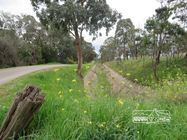
 Eltham District Historical Society Inc
Photograph, Liz Pidgeon, Heritage Excursion; Maroondah Aqueduct, 3 September 2016, 3 September 2016
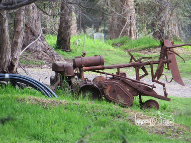
... Heritage Excursion; Maroondah Aqueduct, 3 September 2016... Heritage Excursion - Maroondah Aqueduct Walk - Saturday 3rd September The Maroondah Aqueduct was once a major link in Melbourne’s water supply system. ...Eltham District Historical Society Inc 728 Main Rd Eltham melbourne Heritage Excursion - Maroondah Aqueduct Walk - Saturday 3rd September The Maroondah Aqueduct was once a major link in Melbourne’s water supply system. ...Heritage Excursion - Maroondah Aqueduct Walk - Saturday 3rd September The Maroondah Aqueduct was once a major link in Melbourne’s water supply system. It was built between 1886 and 1891 to transfer water from the Watts River near Healesville to the Preston Reservoir. It was 66 km in length, made up of 41 km of open channel, 10 km of tunnel through hills and 15 km of pipeline across stream valleys known as inverted siphons. The section of the aqueduct through the Eltham area has been abandoned since the 1980s but the open channel has largely been retained. A recreational path follows the aqueduct reserve. For our excursion on 3rd September we intend to walk along the section of the aqueduct adjacent to Allendale Road. This is a section not visited on previous excursions and includes the transition from open channel to the inverted siphon across the Diamond Creek valley. Apart from the aqueduct itself the main feature of the walk is the extensive views across Eltham North and Diamond Creek. Along the way we will talk about the history of the aqueduct and the area. This easy walk is about 3 km return and will take 2 to 2.5 hours. It will start at 2pm at the junction of Allendale Road with Godber Road and Zig Zag Road North, officially Diamond Creek, but on the northern boundary of Eltham. (Melway ref.12 B10). Newsletter No., 229, August 2016 Abandoned rusty farm machinery possibly used for tilling the soil - off the Aqueduct trail Born Digitalmaroondah aqueduct, eltham north, activities, eltham district historical society, heritage excursion, aqueduct trail, farm machinery -
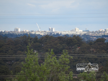 Eltham District Historical Society Inc
Photograph, Liz Pidgeon, Heritage Excursion; Maroondah Aqueduct, 3 September 2016, 3 September 2016
... Heritage Excursion; Maroondah Aqueduct, 3 September 2016...Newsletter No., 229, August 2016 Heritage Excursion - Maroondah Aqueduct Walk - Saturday 3rd September The Maroondah Aqueduct was once a major link in Melbourne’s water supply system. ...Newsletter No., 229, August 2016 Heritage Excursion - Maroondah Aqueduct Walk - Saturday 3rd September The Maroondah Aqueduct was once a major link in Melbourne’s water supply system. ...Photo of Melbourne City skyline. Newsletter No., 229, August 2016 Heritage Excursion - Maroondah Aqueduct Walk - Saturday 3rd September The Maroondah Aqueduct was once a major link in Melbourne’s water supply system. It was built between 1886 and 1891 to transfer water from the Watts River near Healesville to the Preston Reservoir. It was 66 km in length, made up of 41 km of open channel, 10 km of tunnel through hills and 15 km of pipeline across stream valleys known as inverted siphons. The section of the aqueduct through the Eltham area has been abandoned since the 1980s but the open channel has largely been retained. A recreational path follows the aqueduct reserve. For our excursion on 3rd September we intend to walk along the section of the aqueduct adjacent to Allendale Road. This is a section not visited on previous excursions and includes the transition from open channel to the inverted siphon across the Diamond Creek valley. Apart from the aqueduct itself the main feature of the walk is the extensive views across Eltham North and Diamond Creek. Along the way we will talk about the history of the aqueduct and the area. This easy walk is about 3 km return and will take 2 to 2.5 hours. It will start at 2pm at the junction of Allendale Road with Godber Road and Zig Zag Road North, officially Diamond Creek, but on the northern boundary of Eltham. (Melway ref.12 B10). Born Digitalmaroondah aqueduct, eltham north, activities, eltham district historical society, heritage excursion, skyline, melbourne, aqueduct trail -
 Eltham District Historical Society Inc
Photograph, Liz Pidgeon, Heritage Excursion; Maroondah Aqueduct, 3 September 2016, 3 September 2016
... Heritage Excursion; Maroondah Aqueduct, 3 September 2016...Newsletter No., 229, August 2016 Heritage Excursion - Maroondah Aqueduct Walk - Saturday 3rd September The Maroondah Aqueduct was once a major link in Melbourne’s water supply system. ...Eltham District Historical Society Inc 728 Main Rd Eltham melbourne Newsletter No., 229, August 2016 Heritage Excursion - Maroondah Aqueduct Walk - Saturday 3rd September The Maroondah Aqueduct was once a major link in Melbourne’s water supply system. ...Newsletter No., 229, August 2016 Heritage Excursion - Maroondah Aqueduct Walk - Saturday 3rd September The Maroondah Aqueduct was once a major link in Melbourne’s water supply system. It was built between 1886 and 1891 to transfer water from the Watts River near Healesville to the Preston Reservoir. It was 66 km in length, made up of 41 km of open channel, 10 km of tunnel through hills and 15 km of pipeline across stream valleys known as inverted siphons. The section of the aqueduct through the Eltham area has been abandoned since the 1980s but the open channel has largely been retained. A recreational path follows the aqueduct reserve. For our excursion on 3rd September we intend to walk along the section of the aqueduct adjacent to Allendale Road. This is a section not visited on previous excursions and includes the transition from open channel to the inverted siphon across the Diamond Creek valley. Apart from the aqueduct itself the main feature of the walk is the extensive views across Eltham North and Diamond Creek. Along the way we will talk about the history of the aqueduct and the area. This easy walk is about 3 km return and will take 2 to 2.5 hours. It will start at 2pm at the junction of Allendale Road with Godber Road and Zig Zag Road North, officially Diamond Creek, but on the northern boundary of Eltham. (Melway ref.12 B10). Born Digitalmaroondah aqueduct, eltham north, activities, eltham district historical society, heritage excursion, acqueduct trail, spring -
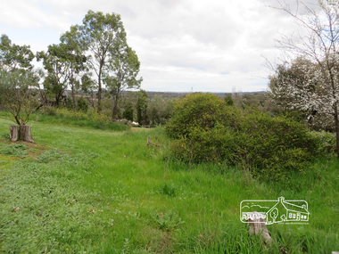
 Eltham District Historical Society Inc
Photograph, Liz Pidgeon, Heritage Excursion; Maroondah Aqueduct, 3 September 2016, 3 September 2016
... Heritage Excursion; Maroondah Aqueduct, 3 September 2016...Newsletter No., 229, August 2016 Heritage Excursion - Maroondah Aqueduct Walk - Saturday 3rd September The Maroondah Aqueduct was once a major link in Melbourne’s water supply system. ...Eltham District Historical Society Inc 728 Main Rd Eltham melbourne Newsletter No., 229, August 2016 Heritage Excursion - Maroondah Aqueduct Walk - Saturday 3rd September The Maroondah Aqueduct was once a major link in Melbourne’s water supply system. ...Newsletter No., 229, August 2016 Heritage Excursion - Maroondah Aqueduct Walk - Saturday 3rd September The Maroondah Aqueduct was once a major link in Melbourne’s water supply system. It was built between 1886 and 1891 to transfer water from the Watts River near Healesville to the Preston Reservoir. It was 66 km in length, made up of 41 km of open channel, 10 km of tunnel through hills and 15 km of pipeline across stream valleys known as inverted siphons. The section of the aqueduct through the Eltham area has been abandoned since the 1980s but the open channel has largely been retained. A recreational path follows the aqueduct reserve. For our excursion on 3rd September we intend to walk along the section of the aqueduct adjacent to Allendale Road. This is a section not visited on previous excursions and includes the transition from open channel to the inverted siphon across the Diamond Creek valley. Apart from the aqueduct itself the main feature of the walk is the extensive views across Eltham North and Diamond Creek. Along the way we will talk about the history of the aqueduct and the area. This easy walk is about 3 km return and will take 2 to 2.5 hours. It will start at 2pm at the junction of Allendale Road with Godber Road and Zig Zag Road North, officially Diamond Creek, but on the northern boundary of Eltham. (Melway ref.12 B10). Born Digitalmaroondah aqueduct, eltham north, activities, eltham district historical society, heritage excursion, aqueduct trail, open channel