Showing 46 items matching "archaeological survey"
-
 Greensborough Historical Society
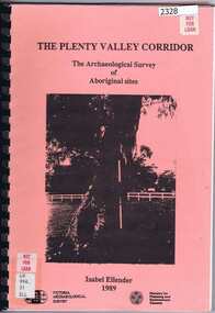
Book, Victoria Archaeological Survey, The Plenty Valley Corridor: the archaeological survey of Aboriginal sites / by Isabel Ellender 1989, 1989_
... The Plenty Valley Corridor: the archaeological survey of Aboriginal sites / by Isabel Ellender 1989....This archaeological survey of th Plenty Valley was conducted by Isabel Ellender in 1989 for the Ministry of Planning and Environment. ...Victoria Archaeological Survey...Book Book Victoria Archaeological Survey ...This archaeological survey of th Plenty Valley was conducted by Isabel Ellender in 1989 for the Ministry of Planning and Environment. The area studied is north of Greensborough to Whittlesea. A number of Aboriginal sites were identified and recommendations made for the future.103 p., illus., maps. Plastic spiral binding.plenty river, aboriginal heritage sites -
 Eltham District Historical Society Inc
Document - Folder, Victoria Archaeological Survey, 1982-1990
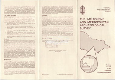
... Victoria Archaeological Survey......Victoria Archaeological Survey...Trifold Leaflet: The Melbourne and Metropolitan Archaeological Survey, Ministry for Conservation Victoria, March 1982 2. ...Flyer: The Archaeological Survey of the Middle Yarra, the Lower Plenty River and the City of Doncaster and Templestowe, 1990 Victoria Archaeological Survey Document Folder ...sites, structures, archaeological significance, victoria archaeological survey -
 Victorian Aboriginal Corporation for Languages
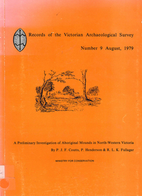
Book, PJF Coutts et al, Records of the Victorian Archaeological Survey : number 9, August 1979 : a preliminary investigation of Aboriginal mounds in North-Western Victoria, 1979
... Records of the Victorian Archaeological Survey : number 9, August 1979 : a preliminary investigation of Aboriginal mounds in North-Western Victoria...Victoria Archaeological Survey...Victorian Aboriginal Corporation for Languages 33 Saxon Street Brunswick melbourne Victoria Archaeological Survey Murray Valley Grampians Maps, charts, graphs, b&w photographs, diagrams Records of the Victorian Archaeological Survey : number 9, August 1979 : a preliminary investigation of Aboriginal mounds in North-Western Victoria Book PJF Coutts P Henderson ...Maps, charts, graphs, b&w photographs, diagramsvictoria archaeological survey, murray valley, grampians -
 Whitehorse Historical Society Inc.
Document, Melbourne and Metropolitan Archaeological survey, 1/03/1982
... Melbourne and Metropolitan Archaeological survey......Victoria Archaeological Survey...Aims (1) identify areas of potential archaeological importance (2) implement a pilot survey program (3) prepare comprehensive proposals for survey of sites. (4) liaise and establish rapport with municipal authorities in study area....Melbourne and Metropolitan Archaeological survey Document Document ...History of Aboriginal occupation of the Melbourne area. Evidence of shell midden refuse associated with their campsites. Evidence of scarred trees and scatters of stone artefacts along major stream systems. It has been established that man was in the Melbourne area 40,000 years ago and that Aboriginal occupation probably continued uninterrupted throughout the extremes of the last ice age, around 20,000 years ago when Port Phillip itself was dry land. Study will take 2 - 3 years. Aims (1) identify areas of potential archaeological importance (2) implement a pilot survey program (3) prepare comprehensive proposals for survey of sites. (4) liaise and establish rapport with municipal authorities in study area.aborigines, wurundjeri, bunurong, australian heritage commission, victoria. ministry for conservation, victoria archaeological survey -
Whitehorse Historical Society Inc.
Book, Archaeological Survey, 1/05/2000 12:00:00 AM
... Archaeological Survey...An archaeological survey at Deep Creek and Loughnan Roads, Mitcham Victoria. ...An archaeological survey at Deep Creek and Loughnan Roads, Mitcham Victoria. ...An archaeological survey at Deep Creek and Loughnan Roads, Mitcham Victoria.An archaeological survey at Deep Creek and Loughnan Roads, Mitcham Victoria. Project No 1660. Survey prepared for Vicroads as part of the preparation for the Eastern Freeway.An archaeological survey at Deep Creek and Loughnan Roads, Mitcham Victoria. historic buildings, archaeology, eastern freeway extension, deep creek road, mitcham, loughnan road, ringwood, vicroads -
Federation University Historical Collection
Booklet, Preserving Our Archaeological Heritage
... archaeology...victorian archaeological survey...Victoria Archaeological Survey...Barker Library (top floor) Mount Helen goldfields archaeology victorian archaeological survey aboriginal sites aboriginal statements register of aboriginal sites glenaire rock shelter lake condah fish trap st arnaud rock wells carisbrook archaeological area Nine page booklet with a ohotograph of a buried dingo skeleton on the cover. contents include: * Legislation Relating to Aboriginal Relics * Register of Aboriginal Sites * Site protection and Preservation * Archaeological Research * Coastal midden * Lake Condah * Archaeological Relics Advisory Committee * Community Education, Training and Information * What to do when youfind a relic Preserving Our Archaeological Heritage Booklet Booklet Victoria Archaeological Survey ...Nine page booklet with a ohotograph of a buried dingo skeleton on the cover. contents include: * Legislation Relating to Aboriginal Relics * Register of Aboriginal Sites * Site protection and Preservation * Archaeological Research * Coastal midden * Lake Condah * Archaeological Relics Advisory Committee * Community Education, Training and Information * What to do when youfind a relicarchaeology, victorian archaeological survey, aboriginal sites, aboriginal statements, register of aboriginal sites, glenaire rock shelter, lake condah fish trap, st arnaud rock wells, carisbrook archaeological area -
Koorie Heritage Trust
Document - Printed Sheets, Bennett, Catherine et al, Report on Aboriginal Skeletal Remains from Tarwin Meadows, South Gippsland - site number 80201/043, 1986
... ...Victorian Archaeological Survey-Aboriginal Skeletal Remains......Victorian Archaeological Survey; Melbourne...Victorian Archaeological Survey-Aboriginal Skeletal Remains 30 P.; appendices; maps; figs.; tables; plates; 32 cm. ...30 P.; appendices; maps; figs.; tables; plates; 32 cm.skeletal remains-aboriginal-tarwin meadows-south gippsland, anthropology-aboriginal-south gippsland., victorian archaeological survey-aboriginal skeletal remains -
 Greensborough Historical Society
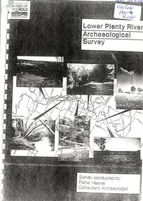
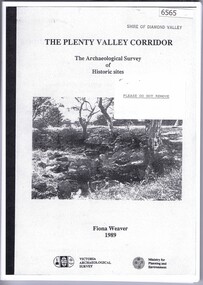
Report, Lower Plenty River Archaeological Survey; Fiona Weaver, 1989_
... Lower Plenty River Archaeological Survey; Fiona Weaver...Archaeological survey of the Lower Plenty River undertaken in 1989-1990 by Fiona Weaver for the Board of Works. ...Lower Plenty River Archaeological Survey; Fiona Weaver Report ...Archaeological survey of the Lower Plenty River undertaken in 1989-1990 by Fiona Weaver for the Board of Works. Indigenous heritage sites along the Plenty River are examined and recommendations made for the preservation and to lessen the impact of development on these sites.Printed on white A4 paper. Approx 92 pages (not numbered). Illus., maps. 2 copies.plenty river, board of works, aboriginal heritage sites, fiona weaver -
 Bacchus Marsh & District Historical Society
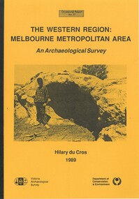
Book, The Western Region: Melbourne Metropolitan Area: An Archaeological Survey
... The Western Region: Melbourne Metropolitan Area: An Archaeological Survey...Part of Occasional reports series (Victoria Archaeological Survey) ; No. 27. Published by Department of Conservation and Environment, Melbourne, 1990. ...AR/SU5 The Western Region: Melbourne Metropolitan Area: An Archaeological Survey Book HIlary Du Cros ...This study aimed to locate and document Aboriginal archaeological sites in the western region of Melbourne. This area was defined by the study as extending out from the western suburbs of Melbourne to the Brisbane Ranges and north beyond Bacchus Marsh. The specific aim of the study was to investigate the Aboriginal archaeology of the Western Plains area in the vicinity west of Melbourne. The Bacchus Marsh, Melton and Werribee shire boundaries of the time defined the areas of the study. The study contains extensive lists of the types of artifacts found the the locations where they were found.Soft cover foolscap size book. 96 pages with b & w illustrations, images and maps (some folded). Part of Occasional reports series (Victoria Archaeological Survey) ; No. 27. Published by Department of Conservation and Environment, Melbourne, 1990. Author, Hilary Du Cros. BMDHS Loc. AR/SU5This study aimed to locate and document Aboriginal archaeological sites in the western region of Melbourne. This area was defined by the study as extending out from the western suburbs of Melbourne to the Brisbane Ranges and north beyond Bacchus Marsh. The specific aim of the study was to investigate the Aboriginal archaeology of the Western Plains area in the vicinity west of Melbourne. The Bacchus Marsh, Melton and Werribee shire boundaries of the time defined the areas of the study. The study contains extensive lists of the types of artifacts found the the locations where they were found. aboriginal australians victoria western plains, aboriginal artifacts, archaelogical sites victoria western plains, aboriginal artifacts bacchus marsh region -
![Book - Article, Fiona Weaver, Lower Plenty River Archaeological Survey by Fiona Weaver [excerpt], 1991](/media/collectors/62fc2e8d3b4c83fe7f279a1c/items/6450d73a49371722cf4f2ee8/item-media/6450d9b949371722cf4f5830/item-fit-380x285.jpg?cb=6) Heidelberg Golf Club
Heidelberg Golf ClubBook - Article, Fiona Weaver, Lower Plenty River Archaeological Survey by Fiona Weaver [excerpt], 1991
... Lower Plenty River Archaeological Survey by Fiona Weaver [excerpt]...Excerpt from Lower Plenty River Archaeological Survey by Fiona Weaver. Section 5 on Aboriginal archaeological sites in the Lower Plenty River area....Lower Plenty River Archaeological Survey by Fiona Weaver [excerpt] Book Article Fiona Weaver ...Excerpt from Lower Plenty River Archaeological Survey by Fiona Weaver. Section 5 on Aboriginal archaeological sites in the Lower Plenty River area.A survey of First Nations sites in the Lower Plenty River area.Copy of part of book.lower plenty river, aboriginal sites -
 Greensborough Historical Society
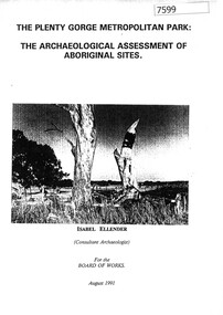
Book, Isabel Ellender, The Plenty Valley Corridor: the archaeological survey of Aboriginal sites / by Isabel Ellender 1991, 1991_
... The Plenty Valley Corridor: the archaeological survey of Aboriginal sites / by Isabel Ellender 1991...This archaeological survey of the Plenty Valley was conducted by Isabel Ellender in 1991 for the Board of Works (Melbourne Water), in particular the Plenty Gorge Metropolitan Park. ...The Plenty Valley Corridor: the archaeological survey of Aboriginal sites / by Isabel Ellender 1991 Book Book Isabel Ellender Melbourne Water ...This archaeological survey of the Plenty Valley was conducted by Isabel Ellender in 1991 for the Board of Works (Melbourne Water), in particular the Plenty Gorge Metropolitan Park. The area studied is north of Greensborough to Whittlesea. A number of Aboriginal sites were identified and recommendations made for the future.67 p., illus., maps. Plastic spiral binding.plenty river, aboriginal heritage sites, plenty gorge metropolitan park -
Save the Dandenongs League Inc.
Archive (item), Save the Dandenongs League Incorporated, An Archaeological Survey of the Upper Yarra Valley and Dandenong Ranges - A Report to the Victoria Archaeological Survey
... An Archaeological Survey of the Upper Yarra Valley and Dandenong Ranges - A Report to the Victoria Archaeological Survey...Upper Yarra Valley and Dandenong Ranges Authority (UYVDRA) An Archaeological Survey of the Upper Yarra Valley and Dandenong Ranges - A Report to the Victoria Archaeological Survey Archive Save the Dandenongs League Incorporated ...upper yarra valley and dandenong ranges authority (uyvdra) -
 Victorian Aboriginal Corporation for Languages
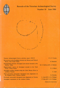
Book, Records of the Victorian Archaeological Survey : number 10, June 1980, 1980
... Records of the Victorian Archaeological Survey : number 10, June 1980...Victorian Aboriginal Corporation for Languages 33 Saxon Street Brunswick melbourne Maps, charts, graphs, b&w photographs, diagrams Records of the Victorian Archaeological Survey : number 10, June 1980 Book PJF Coutts ...Maps, charts, graphs, b&w photographs, diagrams -
Federation University Historical Collection
Booklet - Book, Burra Lotjpa Dunguludja: Victorian Aboriginal Justice Agreement Phase 4, 2018
... Victoria Archaeological Survey...Burra Lotjpa Dunguludja: Victorian Aboriginal Justice Agreement Phase 4 Booklet Book Victoria Archaeological Survey ...Burra Lotjpa Dunguludja means 'Senior Leaders Talking Strong' in Yorta Yorta language.Sixty page book aiming to continue to address Aboriginal over-representation across the justice system, and to progress self-determination as the core policy approach. The vision was to ensure Aboriginal people have access to n equitable justice system that is shaped by self-determination, and protects and upholds their human, civil, legal and cultural rights.aboriginal, martin pakula, tont lovett, marion hansen, aboriginal justice, aboriginal justice caucus, message stick, koori justice unit -
Koorie Heritage Trust
Book, Brown, Anne, Koorie Bush Tucker of the Murray Basin, 1992
... ...Victorian Archaeological Survey...Koorie Bush Tucker of the Murray Basin Book Brown, Anne Victorian Archaeological Survey ...Accompanied by detailed charts this booklet explores the bush tucker of the Murray Basin Aborigines and the methods they used to obtain these foods.15 p.; ill.; tables; footnotes, bib.Accompanied by detailed charts this booklet explores the bush tucker of the Murray Basin Aborigines and the methods they used to obtain these foods.aborigines, murray basin - bush tucker., hunting and gathering - murray basin, aborigines. -
Koorie Heritage Trust
Book, Burke, Christine, Analysis of the lithic assemblage from the Keilor archaeological site : site number : 7822/010, 1990
... ...Victorian Archaeological Survey; La Trobe University...Analysis of the lithic assemblage from the Keilor archaeological site : site number : 7822/010 Book Burke, Christine Victorian Archaeological Survey; La Trobe University ...58 P. appendices; bib. graphs; figs. map.sites - conservation and protection. | keilor /? maribyrnong river (melbourne vic sj55-05) | excavations (archaeology) -- australia -- melbourne (vic.) sites - conservation and protection -
Koorie Heritage Trust
Document - Printed Sheets, Bennett, Catherine, A report on the Aboriginal Skeletal Remains from the Chenery Burial, near Skipton, Site Number: 7522/20, 1987
... ...Victorian Archaeological Survey; Melbourne...A report on the Aboriginal Skeletal Remains from the Chenery Burial, near Skipton, Site Number: 7522/20 Document Printed Sheets Bennett, Catherine Victorian Archaeological Survey; Melbourne ...29 P.; Appendices; plates; figs.; tables; refs.; 33 cm.skeletal remains-aboriginal-chenery near skipton vic. -
Koorie Heritage Trust
Booklet, Brown, Anne, Aborigines in the environment, 1992
... Melbourne : Victorian Archaeological Survey....; Aborigines in the environment Booklet Brown, Anne Melbourne : Victorian Archaeological Survey ...This book examines three of the environmental zones of south-easternAustralia in the period immediately before white invasion.pp.26; illus.; figs.; This book examines three of the environmental zones of south-easternAustralia in the period immediately before white invasion. aboriginal australians -- victoria -- antiquities. | aboriginal australians -- victoria -- hunting. | aboriginal australians -- victoria -- food. | human ecology -- victoria. -
 Greensborough Historical Society
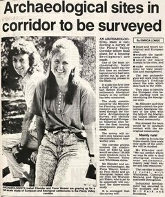
Newspaper - Newspaper Clipping - Digital Image, Diamond Valley News, Archaeological sites in corridor to be surveyed, 1990c
... archaeology...victorian archaeological survey...An undated newspaper article announcing an archaeological survey of the Plenty Valley corridor to be undertaken by Isabel Ellender and Fiona Weaver. ...Greensborough Historical Society 34A Glenauburn Road Lower Plenty Lower Plenty melbourne An undated newspaper article announcing an archaeological survey of the Plenty Valley corridor to be undertaken by Isabel Ellender and Fiona Weaver. ...An undated newspaper article announcing an archaeological survey of the Plenty Valley corridor to be undertaken by Isabel Ellender and Fiona Weaver. The findings were published separately by Ellender and Weaver.Digital copy of newspaper articleplenty valley, plenty river, victoria archaeology, victorian archaeological survey, isabel ellender, fiona weaver -
Tatura Irrigation & Wartime Camps Museum
Audio Tape, Walking tour of Camp 1 with Jenny Dumble who conducted an archaelogical survey thereof, 1990
... ...archaeological survey...Walking tour of camp 1 with Jenny Dumble who had just completed an archaeological survey of the camp remains. Members of T & D Historical Society accompanied....Jenny Dumble archaeological survey Camp remains Camp 1 Jenny Dumble audio tape 90 minutes Walking tour of Camp 1 with Jenny Dumble who conducted an archaelogical survey thereof., Audio Tape. ...Walking tour of camp 1 with Jenny Dumble who had just completed an archaeological survey of the camp remains. Members of T & D Historical Society accompanied.audio tape 90 minutesCamp 1 Jenny Dumblejenny dumble, archaeological survey, camp remains -
 Bendigo Historical Society Inc.
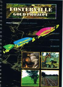
Document - FOSTERVILLE GOLD MINE COLLECTION: PROJECT UPGRADE TECHNICAL APPENDICES
... Aboriginal Archaeological survey...Topics: hydro geological assessment; surface drainage study, noise emission to residential properties, flora survey, tailings dam site; flora survey Wellesford Forest; Daley's Hill Plant List; diurnal Avifauna Survey - Wellesford Forest; survey of vertebrate fauna - Wellesford Forest; brief summary of fauna - Daley's Hill, Axedale, Aboriginal Archaeological survey; archaeological investigation Fosterville; traffic survey - Fosterville Sulphide Project; traffic report....Topics: hydro geological assessment; surface drainage study, noise emission to residential properties, flora survey, tailings dam site; flora survey Wellesford Forest; Daley's Hill Plant List; diurnal Avifauna Survey - Wellesford Forest; survey of vertebrate fauna - Wellesford Forest; brief summary of fauna - Daley's Hill, Axedale, Aboriginal Archaeological survey; archaeological investigation Fosterville; traffic survey - Fosterville Sulphide Project; traffic report. ...Black cover book, wire binding. Pages in reports numbered individually, overall approx 250 page report. On front: "Fosterville Gold Project' Project upgrade, EES Technical Appendix B. Central North, Central Ellesmere, Harringtons Hill." Page 1 'Perseverance Exploration Pty Limited' Book contains technical appendices. Topics: hydro geological assessment; surface drainage study, noise emission to residential properties, flora survey, tailings dam site; flora survey Wellesford Forest; Daley's Hill Plant List; diurnal Avifauna Survey - Wellesford Forest; survey of vertebrate fauna - Wellesford Forest; brief summary of fauna - Daley's Hill, Axedale, Aboriginal Archaeological survey; archaeological investigation Fosterville; traffic survey - Fosterville Sulphide Project; traffic report.bendigo, mining, fosterville gold mine, hydro geological assessment, surface drainage study, noise emission to residential properties, flora survey, tailings dam site, flora survey wellesford forest, daley's hill plant list, diurnal avifauna survey - wellesford forest, survey of vertebrate fauna - wellesford forest, brief summary of fauna - daley's hill, axedale, aboriginal archaeological survey, archaeological investigation fosterville, traffic survey - fosterville sulphide project, traffic report. -
 The Beechworth Burke Museum
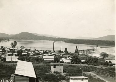
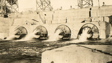
Photograph, 25 October 1930
... ...Archaeological survey...Dam workers often settled their families in Mitta Junction Village and Wodonga. Archaeological surveys were completed by Austral Archaeology, which was done when the Department of Land & Water Conservation was doing work to improve Hume Dam. ...Dam workers often settled their families in Mitta Junction Village and Wodonga. Archaeological surveys were completed by Austral Archaeology, which was done when the Department of Land & Water Conservation was doing work to improve Hume Dam. ...Taken on 25 October 1930, various houses with the Hume Dam under construction are depicted in the background. The construction of the Hume Dam took place from 1919 to 1936. At the time of construction, it was the second largest dam in the world. It was also one of the earliest civil projects developed after the Federation. Some of the Dam workers consisted of World War I veterans. Dam workers often settled their families in Mitta Junction Village and Wodonga. Archaeological surveys were completed by Austral Archaeology, which was done when the Department of Land & Water Conservation was doing work to improve Hume Dam. The archaeological report that came out of the survey recommended three sites of interest where archaeological excavation should be done: Camp Ganger’s Quarters, Stableman’s Quarters, and the Industrial Dump. The excavation uncovered artefacts. Mitta Mitta: Mitta Mitta is situated between Mount Welcome and Mount Misery. It is named after the river that explorers Hume and Hovell discovered in 1824. The town would eventually become a huge gold mining town. Mitta Mitta is called Midamodunga by the local Indigenous peoples Wodonga: Wodonga is situated on the Murray River and is part of North East Victoria. Hume and Hovell: Hamilton Hume (1979-1873) and William Hilton Hovell (1786-1875). W. H. Hovell was born in Norfolk England and Hume was born in Parramatta, New South Wales Hovell and Hume undertook an exploration journey in 1824 and thought they discovered a river, which turned out to be the Murray River. They returned home in 1825, but returned to the area in 1826 and discovered coal in the area. This photo is historically significant as it shows the Hume Dam under construction in 1930. The Dam was named after Hamilton Hume, who is an important historical figure for this area as he helped discover the area where resources were found. Black and white rectangular photograph printer unmountedReverse: 1997.3145/ 84-20-2construction, houses, veterans, mitta junction village, hume dam, world war i, federation, wodonga, archaeological survey, excavation, austral archaeology, department of land & water conservation, camp ganger's quarter's, stableman's quarters, industrial dump, artefacts, mitta mitta, mount welcome, mount misery, murray river, hamilton hume, william hilton hovell, hume and hovell expedition -
 The Beechworth Burke Museum
Photograph, 25 October 1930
... ...Archaeological survey...Dam workers often settled their families in Mitta Junction Village and Wodonga. Archaeological surveys were completed by Austral Archaeology, which was done when the Department of Land & Water Conservation was doing work to improve Hume Dam. ...Dam workers often settled their families in Mitta Junction Village and Wodonga. Archaeological surveys were completed by Austral Archaeology, which was done when the Department of Land & Water Conservation was doing work to improve Hume Dam. ...Taken on 25 October 1930, various houses with the Hume Dam under construction are depicted in the background. The construction of the Hume Dam took place from 1919 to 1936. At the time of construction, it was the second largest dam in the world. It was also one of the earliest civil projects developed after the Federation. Some of the Dam workers consisted of World War I veterans. Dam workers often settled their families in Mitta Junction Village and Wodonga. Archaeological surveys were completed by Austral Archaeology, which was done when the Department of Land & Water Conservation was doing work to improve Hume Dam. The archaeological report that came out of the survey recommended three sites of interest where archaeological excavation should be done: Camp Ganger’s Quarters, Stableman’s Quarters, and the Industrial Dump. The excavation uncovered artefacts. Mitta Mitta: Mitta Mitta is situated between Mount Welcome and Mount Misery. It is named after the river that explorers Hume and Hovell discovered in 1824. The town would eventually become a huge gold mining town. Mitta Mitta is called Midamodunga by the local Indigenous peoples Wodonga: Wodonga is situated on the Murray River and is part of North East Victoria. Hume and Hovell: Hamilton Hume (1979-1873) and William Hilton Hovell (1786-1875). W. H. Hovell was born in Norfolk England and Hume was born in Parramatta, New South Wales Hovell and Hume undertook an exploration journey in 1824 and thought they discovered a river, which turned out to be the Murray River. They returned home in 1825, but returned to the area in 1826 and discovered coal in the area.This photo is historically significant as it shows the Hume Dam under construction in 1930. The Dam was named after Hamilton Hume, who is an important historical figure for this area as he helped discover the area where resources were found.Black and white rectangular photograph printer unmountedReverse: 84-20-1/ 1997.3147construction, houses, veterans, mitta junction village, hume dam, world war i, federation, wodonga, archaeological survey, excavation, austral archaeology, department of land & water conservation, camp ganger's quarter's, stableman's quarters, industrial dump, artefacts, mitta mitta, mount welcome, mount misery, murray river, hamilton hume, william hilton hovell, hume and hovell expedition -
 The Beechworth Burke Museum
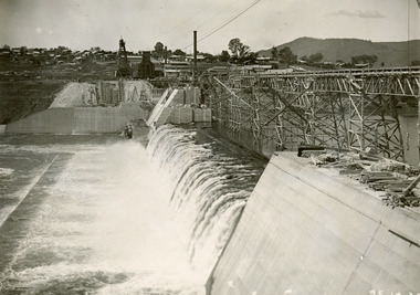
Photograph
... ...Archaeological survey...Dam workers often settled their families in Mitta Junction Village and Wodonga. Archaeological surveys were completed by Austral Archaeology, which was done when the Department of Land & Water Conservation was doing work to improve Hume Dam. ...Dam workers often settled their families in Mitta Junction Village and Wodonga. Archaeological surveys were completed by Austral Archaeology, which was done when the Department of Land & Water Conservation was doing work to improve Hume Dam. ...Taken on 25 October 1930, various houses with the Hume Dam under construction are depicted in the background. The construction of the Hume Dam took place from 1919 to 1936. At the time of construction, it was the second largest dam in the world. It was also one of the earliest civil projects developed after the Federation. Some of the Dam workers consisted of World War I veterans. Dam workers often settled their families in Mitta Junction Village and Wodonga. Archaeological surveys were completed by Austral Archaeology, which was done when the Department of Land & Water Conservation was doing work to improve Hume Dam. The archaeological report that came out of the survey recommended three sites of interest where archaeological excavation should be done: Camp Ganger’s Quarters, Stableman’s Quarters, and the Industrial Dump. The excavation uncovered artefacts. Mitta Mitta: Mitta Mitta is situated between Mount Welcome and Mount Misery. It is named after the river that explorers Hume and Hovell discovered in 1824. The town would eventually become a huge gold mining town. Mitta Mitta is called Midamodunga by the local Indigenous peoples Wodonga: Wodonga is situated on the Murray River and is part of North East Victoria. Hume and Hovell: Hamilton Hume (1979-1873) and William Hilton Hovell (1786-1875). W. H. Hovell was born in Norfolk England and Hume was born in Parramatta, New South Wales Hovell and Hume undertook an exploration journey in 1824 and thought they discovered a river, which turned out to be the Murray River. They returned home in 1825, but returned to the area in 1826 and discovered coal in the area. This photo is historically significant as it shows the Hume Dam under construction in 1930. The Dam was named after Hamilton Hume, who is an important historical figure for this area as he helped discover the area where resources were found.Sepia rectangular photograph printed unmountedReverse: 84-19-5 / 1997.3185/ Values & spillway. / When completed the wall / will be as high as the / scaffolding. [featuring trademark: kodak print]construction, houses, veterans, mitta junction village, hume dam, world war i, federation, wodonga, archaeological survey, excavation, austral archaeology, department of land & water conservation, camp ganger's quarter's, stableman's quarters, industrial dump, artefacts, mitta mitta, mount welcome, mount misery, murray river, hamilton hume, william hilton hovell, hume and hovell expedition -
 The Beechworth Burke Museum
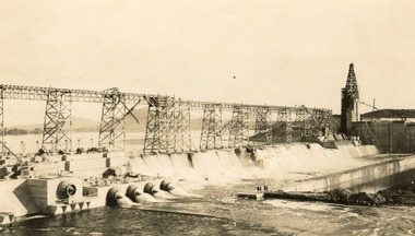
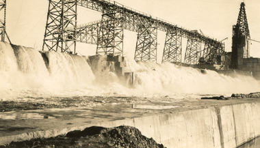
Photograph, c1930
... ...Archaeological survey...Dam workers often settled their families in Mitta Junction Village and Wodonga. Archaeological surveys were completed by Austral Archaeology, which was done when the Department of Land & Water Conservation was doing work to improve Hume Dam. ...Dam workers often settled their families in Mitta Junction Village and Wodonga. Archaeological surveys were completed by Austral Archaeology, which was done when the Department of Land & Water Conservation was doing work to improve Hume Dam. ...Taken on 25 October 1930, various houses with the Hume Dam under construction are depicted in the background. The construction of the Hume Dam took place from 1919 to 1936. At the time of construction, it was the second largest dam in the world. It was also one of the earliest civil projects developed after the Federation. Some of the Dam workers consisted of World War I veterans. Dam workers often settled their families in Mitta Junction Village and Wodonga. Archaeological surveys were completed by Austral Archaeology, which was done when the Department of Land & Water Conservation was doing work to improve Hume Dam. The archaeological report that came out of the survey recommended three sites of interest where archaeological excavation should be done: Camp Ganger’s Quarters, Stableman’s Quarters, and the Industrial Dump. The excavation uncovered artefacts. Mitta Mitta: Mitta Mitta is situated between Mount Welcome and Mount Misery. It is named after the river that explorers Hume and Hovell discovered in 1824. The town would eventually become a huge gold mining town. Mitta Mitta is called Midamodunga by the local Indigenous peoples Wodonga: Wodonga is situated on the Murray River and is part of North East Victoria. Hume and Hovell: Hamilton Hume (1979-1873) and William Hilton Hovell (1786-1875). W. H. Hovell was born in Norfolk England and Hume was born in Parramatta, New South Wales Hovell and Hume undertook an exploration journey in 1824 and thought they discovered a river, which turned out to be the Murray River. They returned home in 1825, but returned to the area in 1826 and discovered coal in the area.This photo is historically significant as it shows the Hume Dam under construction in 1930. The Dam was named after Hamilton Hume, who is an important historical figure for this area as he helped discover the area where resources were found.Sepia rectangular photograph printed unmountedReverse: 84-19-2/ 1997.3188/ These are the four / release valves they are / not always open (illegible) this / when closed the water flows / over the spillway. [featuring trademark: kodak print] photograph number: 354construction, houses, veterans, mitta junction village, hume dam, world war i, federation, wodonga, archaeological survey, excavation, austral archaeology, department of land & water conservation, camp ganger's quarter's, stableman's quarters, industrial dump, artefacts, mitta mitta, mount welcome, mount misery, murray river, hamilton hume, william hilton hovell, hume and hovell expedition -
 The Beechworth Burke Museum
Photograph, 25 October 1930
... ...Archaeological survey...Dam workers often settled their families in Mitta Junction Village and Wodonga. Archaeological surveys were completed by Austral Archaeology, which was done when the Department of Land & Water Conservation was doing work to improve Hume Dam. ...Dam workers often settled their families in Mitta Junction Village and Wodonga. Archaeological surveys were completed by Austral Archaeology, which was done when the Department of Land & Water Conservation was doing work to improve Hume Dam. ...Taken on 25 October 1930, various houses with the Hume Dam under construction are depicted in the background. The construction of the Hume Dam took place from 1919 to 1936. At the time of construction, it was the second largest dam in the world. It was also one of the earliest civil projects developed after the Federation. Some of the Dam workers consisted of World War I veterans. Dam workers often settled their families in Mitta Junction Village and Wodonga. Archaeological surveys were completed by Austral Archaeology, which was done when the Department of Land & Water Conservation was doing work to improve Hume Dam. The archaeological report that came out of the survey recommended three sites of interest where archaeological excavation should be done: Camp Ganger’s Quarters, Stableman’s Quarters, and the Industrial Dump. The excavation uncovered artefacts. Mitta Mitta: Mitta Mitta is situated between Mount Welcome and Mount Misery. It is named after the river that explorers Hume and Hovell discovered in 1824. The town would eventually become a huge gold mining town. Mitta Mitta is called Midamodunga by the local Indigenous peoples Wodonga: Wodonga is situated on the Murray River and is part of North East Victoria. Hume and Hovell: Hamilton Hume (1979-1873) and William Hilton Hovell (1786-1875). W. H. Hovell was born in Norfolk England and Hume was born in Parramatta, New South Wales Hovell and Hume undertook an exploration journey in 1824 and thought they discovered a river, which turned out to be the Murray River. They returned home in 1825, but returned to the area in 1826 and discovered coal in the area.This photo is historically significant as it shows the Hume Dam under construction in 1930. The Dam was named after Hamilton Hume, who is an important historical figure for this area as he helped discover the area where resources were found.Sepia rectangular photograph printed unmountedReverse: 84-19-6/ 1997.3187/ The spillway [featuring trademark: kodak print] construction, houses, veterans, mitta junction village, hume dam, world war i, federation, wodonga, archaeological survey, excavation, austral archaeology, department of land & water conservation, camp ganger's quarter's, stableman's quarters, industrial dump, artefacts, mitta mitta, mount welcome, mount misery, murray river, hamilton hume, william hilton hovell, hume and hovell expedition -
Federation University Historical Collection
Document, Eureka Stockade Site, 1991, 14/05/2014
... Ten typed pages of notes relating to the site of the Eureka Stockade by Iain Stuart of the Victoria Archaeological survey...It is not certain where the actual site of the stockade is. eureka eureka stockade eureka stockade site phillip clingin iain stuart eureka eureka stockade eureka stockade site phillip clingin iain stuart Ten typed pages of notes relating to the site of the Eureka Stockade by Iain Stuart of the Victoria Archaeological survey Eureka Stockade Site, 1991 Document Document ...The Eureka Stockade was attached on 03 December 1854. It is not certain where the actual site of the stockade is. Ten typed pages of notes relating to the site of the Eureka Stockade by Iain Stuart of the Victoria Archaeological surveyeureka, eureka stockade, eureka stockade site, phillip clingin, iain stuart, eureka, eureka stockade, eureka stockade site, phillip clingin, iain stuart -
 Greensborough Historical Society
Book, The Plenty Valley Corridor: the archaelogical survey of historic sites, by Fiona Weaver, for the Ministry of Planning & Environment, 1989_
... ...victorian archaeological survey...The study was intended to provide a brief history of Aboriginal and European occupation and use of the area and an outline of the geography of the chief areas of cultural heritage concern, with recommendations for protection of significant cultural sites and recommendations for further research, survey and consultation. plenty river fiona weaver victorian archaeological survey 115 p., photocopy, unbound. Illus., maps The Plenty Valley Corridor: the archaelogical survey of historic sites, by Fiona Weaver, for the Ministry of Planning & Environment Book Book Fiona Weaver Victoria Archaelogical Survey Fiona Weaver Victoria Archaelogical Survey ...The Victorian Archaelogical Survey managed this study onbehalf of the Ministry for Planning & Environment. The study was intended to provide a brief history of Aboriginal and European occupation and use of the area and an outline of the geography of the chief areas of cultural heritage concern, with recommendations for protection of significant cultural sites and recommendations for further research, survey and consultation.115 p., photocopy, unbound. Illus., mapsplenty river, fiona weaver, victorian archaeological survey -
 Bendigo Historical Society Inc.
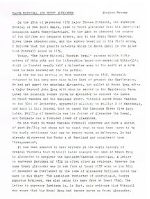
Document - MAJOR MITCHELL AND MOUNT ALEXANDER
... Records of the Victorian Archaeological Survey Number 5...History House 11 Mackenzie Street Bendigo goldfields DOCUMENT Major Mitchell and Mount Alexander Tommy-Came-Last The Major Mitchell Tourist Trail Major General John Byng Phillip of Macedonia Alexander the Great Henty s Surveyor Davidson Alexander Mollison George Augustus Robinson William Morton Mr Charles Hotson Ebden John Randell Public Library of Melbourne Les Blake Governor Burke Phillip Parker King Crown Solicitor Henry Field Gurner Arthur Phillip Hume Australia Felix Expedition L Blake Place Names of Victoria G Brenmer Booklet for Secondary Schools M Cannon Historical Records of Victoria Vol 1 J H L Cumpston Thomas Mitchell Surveyor General and Explorer H F Gurner Chronicle of Port Phillip T L Mitchell Three Expeditions into the Interior of Eastern Australia A F Mollison An Overlanding Diary W L Morton Adventures of a Pioneer M S 5188 Itinerary from the Journal of the Exploring Expedition returning from Portland Bay M S 5189 Mitchell's 1837 Map J O Randell Pastoral Settlement in Northern Victoria Vol 1 Pastoral Settlement in Northern Victoria Vol 2 Records of the Victorian Archaeological Survey Number 5 Journals of George Augustus Robinson T C Sargent Some Peninsular Names in Australia Felix W H Wells A Geographical Dictionary or Gazetteer of the Australian Colonies Typed notes mentioning the naming of Mount Alexander, Coliban, Campaspe and who named them. ...Typed notes mentioning the naming of Mount Alexander, Coliban, Campaspe and who named them. Also the origins of the names.document, major mitchell and mount alexander, tommy-came-last, the major mitchell tourist trail, major general john byng, phillip of macedonia, alexander the great, henty s, surveyor davidson, alexander mollison, george augustus robinson, william morton, mr charles hotson ebden, john randell, public library of melbourne, les blake, governor burke, phillip parker king, crown solicitor henry field gurner, arthur phillip, hume, australia felix expedition, l blake, place names of victoria, g brenmer, booklet for secondary schools, m cannon, historical records of victoria vol 1, j h l cumpston, thomas mitchell surveyor general and explorer, h f gurner, chronicle of port phillip, t l mitchell, three expeditions into the interior of eastern australia, a f mollison, an overlanding diary, w l morton, adventures of a pioneer, m s 5188, itinerary from the journal of the exploring expedition returning from portland bay, m s 5189, mitchell's 1837 map, j o randell, pastoral settlement in northern victoria vol 1, pastoral settlement in northern victoria vol 2, records of the victorian archaeological survey number 5, journals of george augustus robinson, t c sargent, some peninsular names in australia felix, w h wells, a geographical dictionary or gazetteer of the australian colonies -
Marysville & District Historical Society
Article (item) - Book Extract, Aboriginal History, Unknown
... ...victorian archaeological survey...The extract also covers current (1991) status of Aboriginal affairs and European settlement of the area. kulin nation woiworung taungurong bunurong watherong jajowrong wurrundjeri-willam waring-ilam-balluk goulburn valley acheron valley upper goulburn district eildon-thornton eildon homestead o'rourke thornton assistant protector thomas yarra valley kilmore mount william jt gellibrand william buckley major mitchell port phillip murray river yorta yorta yowung-illam-balluk waring-illam-balluk ngurai-illam-wurrung kurnai nation protectorate system victoria george robinson chief protector willam thomas james dredge edward parker charles sievewright central board for the protection of aborigines presbyterian mission anglican mission moravian mission wonga munnarin beaning murrin murrin parugean baruppin koo-gurrin acheron river little river acheron run peter snodgrass stephen jones barak dividing range black spur watts river badger creek healesville coranderrk victorian christmas bush aboriginal and torres strait islander heritage protection act 1984 archaelological and aboriginal relics preservation act 1972 camp jungai rubicon warrawa college victorian archaeological survey hume and hovell molesworth broadford william hamilton alexandra mansfield avenel tallarook worrough john cotton trawool valley seymour pyalong gold mining central victoria strath creek reedy creek yea jamieson marysville jordan goldfields comet mine wandong melbourne-albury railway rabbit plague narbethong lord kitchener puckapunyal military camp 1944 decentralisation policy eildon weir hume freeway bypass timber industry australian paper manufacturers mill An extract from a book regarding a brief history of the Kulin nation of the North Central district of Victoria. ...An extract from a book regarding a brief history of the Kulin nation of the North Central district of Victoria.An extract from a book regarding a brief history of the Kulin nation of the North Central district of Victoria. This history covered is both prior to European history and post-European history. The extract also covers current (1991) status of Aboriginal affairs and European settlement of the area.kulin nation, woiworung, taungurong, bunurong, watherong, jajowrong, wurrundjeri-willam, waring-ilam-balluk, goulburn valley, acheron valley, upper goulburn district, eildon-thornton, eildon homestead, o'rourke, thornton, assistant protector thomas, yarra valley, kilmore, mount william, jt gellibrand, william buckley, major mitchell, port phillip, murray river, yorta yorta, yowung-illam-balluk, waring-illam-balluk, ngurai-illam-wurrung, kurnai nation, protectorate system, victoria, george robinson, chief protector, willam thomas, james dredge, edward parker, charles sievewright, central board for the protection of aborigines, presbyterian mission, anglican mission, moravian mission, wonga, munnarin, beaning, murrin murrin, parugean, baruppin, koo-gurrin, acheron river, little river, acheron run, peter snodgrass, stephen jones, barak, dividing range, black spur, watts river, badger creek, healesville, coranderrk, victorian christmas bush, aboriginal and torres strait islander heritage protection act 1984, archaelological and aboriginal relics preservation act 1972, camp jungai, rubicon, warrawa college, victorian archaeological survey, hume and hovell, molesworth, broadford, william hamilton, alexandra, mansfield, avenel, tallarook, worrough, john cotton, trawool valley, seymour, pyalong, gold mining, central victoria, strath creek, reedy creek, yea, jamieson, marysville, jordan goldfields, comet mine, wandong, melbourne-albury railway, rabbit plague, narbethong, lord kitchener, puckapunyal military camp, 1944 decentralisation policy, eildon weir, hume freeway bypass, timber industry, australian paper manufacturers mill