Showing 17580 items matching "area"
-
 Falls Creek Historical Society
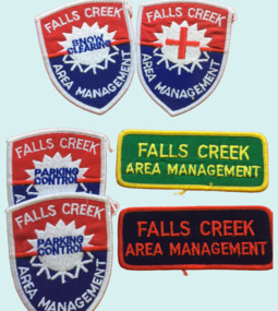
Badge - Falls Creek Area Management Cloth Badges
... Falls Creek Area Management Cloth Badges...This Committee was responsibility for long term planning for the Falls Creek Tourist Area as well as the day to day running of the Village, These patches were part of the uniform of people employed by the Management Committee....A group of cloth badges indicating the role of personnel employed by the Falls Creek Area Management. ... Shield shaped badges - 2 Falls Creek Area Management - PARKING CONTROL 1 Falls Creek Area Management - with red cross of SKI PATROL Rectangular - Green and yellow - FALLS CREEK AREA MANAGEMENT Red and blue - FALLS CREEK AREA MANAGEMENT...Falls Creek Area Management Cloth Badges Badge Falls Creek Area Management Cloth Badges ...Falls Creek was operated by the Falls Creek Area Management Committee. Its composition changed over time but generally the Committee was composed of representatives of the State Electricity Commission, Representatives from Ski Clubs and commercial enterprises, the Country Roads Board, the Ski Tow company and a Representative of the Upper Murray Regional Committee of the Central Planning Authority. This Committee was responsibility for long term planning for the Falls Creek Tourist Area as well as the day to day running of the Village, These patches were part of the uniform of people employed by the Management Committee.These cloth badges are significant because they indicated employees of the Area Management Committee and the role they played in Falls Creek.A group of cloth badges indicating the role of personnel employed by the Falls Creek Area Management. Shield shaped badges - 2 Falls Creek Area Management - PARKING CONTROL 1 Falls Creek Area Management - with red cross of SKI PATROL Rectangular - Green and yellow - FALLS CREEK AREA MANAGEMENT Red and blue - FALLS CREEK AREA MANAGEMENTfalls creek village, falls creek area management committee -
 Bendigo Military Museum
Photograph - 4th Field Survey Squadron Regimental Training, Murray Bridge Training Area, SA, 1988
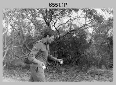
... 4th Field Survey Squadron Regimental Training, Murray Bridge Training Area, SA...This is a set of eight photographs of 4th Field Survey Squadron personnel undergoing regimental training held at the Murray Bridge Training Area of South Australia in 1988. The aim of regimental training was typically to provide personnel a practical knowledge of infantry and minor tactics at the section level, navigation and map reading, RATEL and survival in the Field....This is a set of eight photographs of 4th Field Survey Squadron personnel undergoing regimental training held at the Murray Bridge Training Area of South Australia in 1988. The black and white photographs are on 35mm negative film and are part of the Army Survey Regiment’s Collection. ...Murray Bridge Training Area, South Australia...L to R: Unidentified, SGT Laurie Justin, remainder unidentified. 4th Field Survey Squadron Regimental Training, Murray Bridge Training Area, SA Photograph 4th Field Survey Squadron Regimental Training, Murray Bridge Training Area, SA Army Survey Regiment ...This is a set of eight photographs of 4th Field Survey Squadron personnel undergoing regimental training held at the Murray Bridge Training Area of South Australia in 1988. The aim of regimental training was typically to provide personnel a practical knowledge of infantry and minor tactics at the section level, navigation and map reading, RATEL and survival in the Field.This is a set of eight photographs of 4th Field Survey Squadron personnel undergoing regimental training held at the Murray Bridge Training Area of South Australia in 1988. The black and white photographs are on 35mm negative film and are part of the Army Survey Regiment’s Collection. The photographs were scanned at 96 dpi. .1) - Photo, black & white, 1988. CPL Steve McGuiness. .2) - Photo, black & white, 1988. L to R: Unidentified, SPR Charmian McKean. .3) - Photo, black & white, 1988. SPR Andrew Quin. .4) - Photo, black & white, 1988. L to R: Unidentified, LT Geoff ‘GT’ Ford. .5) & .6) - Photo, black & white, 1988. Unidentified personnel. .7) - Photo, black & white, 1988. L to R: Unidentified (x2), SPR Perry Langeberg, SGT Laurie Justin (3rd from right), remainder unidentified. .8) - Photo, black & white, 1988. L to R: Unidentified, SGT Laurie Justin, remainder unidentified..1P to .8P – There are no personnel identified. ‘1988 REGT ADV TRAINING MURRAY BRIDGE’ annotated on negatives sleeve.royal australian survey corps, rasvy, 4 fd svy sqn -
 Ballarat Tramway Museum
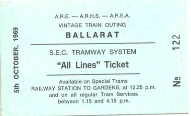
Ephemera - Ticket, Vintage Train - ARE - ARHS - AREA, Combined tour ticket Ballarat, Sep. 1969
... ... AREA...Special "All Lines" ticket on aqua green index board or card for an ARE - ARHS - AREA Vintage Train Outing to Ballarat for 5/10/1969, numbered "No. 122". ...Vintage Train - ARE - ARHS - AREA...Ballarat Tramway Museum South Gardens Reserve Wendouree Parade Ballarat Ballarat goldfields Trams tramways Tickets All Lines Tickets Vintage Train ARE AREA ARHS Special "All Lines" ticket on aqua green index board or card for an ARE - ARHS - AREA Vintage Train Outing to Ballarat for 5/10/1969, numbered "No. 122". ...Special "All Lines" ticket on aqua green index board or card for an ARE - ARHS - AREA Vintage Train Outing to Ballarat for 5/10/1969, numbered "No. 122". Notes as available on Special Trams Railway Station to Gardens at 12.25 pm and on all regular Tram Services between 1.15 and 4.15pm. See Reg. Item 3037 for photos of this event - ? (not 100% certain of this statement - WAD 18/2/05) Three further copies of the ticket added 1/11/2005 - Nos. 143, 146 and 147.trams, tramways, tickets, all lines tickets, vintage train, are, area, arhs -
 Stawell Historical Society Inc
Photograph - Aunde Album 29, Raschel Area, 2002
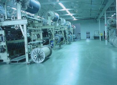
... Raschel Area...Colour landscape photo: Raschel Area Spools on machines...Raschel Area...Stawell Historical Society Inc 46 Longfield St Stawell grampians Aunde / Norwellan Textiles North Western Woollen Mills became Norwellan Textiles then AUNDE Industry Aunde Raschel Area Colour landscape photo: Raschel Area Spools on machines Raschel Area Photograph Aunde Album 29 ...Aunde / Norwellan Textiles North Western Woollen Mills became Norwellan Textiles then AUNDEColour landscape photo: Raschel Area Spools on machinesRaschel Areaindustry, aunde -
 Orbost & District Historical Society
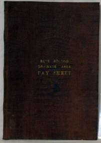
account book, BETE BOLONG DRAINAGE AREA PAY SHEET, 1910 - 1913
... BETE BOLONG DRAINAGE AREA PAY SHEET...The shire covered an area of 9,347 square kilometres and existed from 1892 until 1994 when it became part of the East Gippsland Shire Council. ...In gold lettering on the front is "BETE BOLONG DRAINAGE AREA PAY SHEET". It contains records of payments made for work done 1910-1913....In gold lettering on the front is "BETE BOLONG DRAINAGE AREA PAY SHEET"....BETE BOLONG DRAINAGE AREA PAY SHEET account book ...This account book was used by the Orbost Shire council to record payments made for work done on the Bete Bolong Drainage Area between 1910 and 1913. The item was donated to Orbost & District Historical society from P.R.O.V. as a Place of Deposit (POD) item for safe keeping by a local history group or museum. The shire covered an area of 9,347 square kilometres and existed from 1892 until 1994 when it became part of the East Gippsland Shire Council. Orbost was at first included in the Bairnsdale Shire from 1882 and was later part of the Tambo Shire. Because of travelling distances the Croajingalong Shire was created in 1892 (name changed to Orbost Shire 17.2.1893 with James Cameron as the first Shire President. In 1994 it amalgamated to become part of East Gippsland Shire Council. This item is a hand-written record of the accounts of the local government. The Orbost Shire Council no longer exists having been absorbed by the East Gippsland Shire Council.A brown leatherette, hard cover book. In gold lettering on the front is "BETE BOLONG DRAINAGE AREA PAY SHEET". It contains records of payments made for work done 1910-1913.In gold lettering on the front is "BETE BOLONG DRAINAGE AREA PAY SHEET".bete-bolong-drainage-area accounts orbost-shire -council -
 Bendigo Military Museum
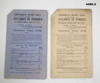
Pamphlet - SYLLABUS OF PARADES, Training Area 67B, C.1916
... Front covers have one name both "Capt Laidler C.O 67th Batt Senior Cadets", on rear .1) "R.M. Marks Capt Area Officer 67B". .2) has "R.H. Beers Area Officer 67B".....1) Syllabus of Training area 67B, blue colour, folds in half, all print in black type, covers Parade time for the quarter ending June 30th 1916, Senior cadet Training details types of Training and quotas by years and birth date, rear page has list of Instructions. .2) Same as .1) except light fawn colour and Parades ending September 30th 1916....Training Area 67B...Front covers have one name both "Capt Laidler C.O 67th Batt Senior Cadets", on rear .1) "R.M. Marks Capt Area Officer 67B". .2) has "R.H. Beers Area Officer 67B". ...67B is part of the local Bendigo area Training Battalion. Both cards cover B Coy No 5 - 8 Platoons, C Coy covers 9 - 10 Pl's plus Technical school Pl's 11 - 12. Front covers have one name both "Capt Laidler C.O 67th Batt Senior Cadets", on rear .1) "R.M. Marks Capt Area Officer 67B". .2) has "R.H. Beers Area Officer 67B"..1) Syllabus of Training area 67B, blue colour, folds in half, all print in black type, covers Parade time for the quarter ending June 30th 1916, Senior cadet Training details types of Training and quotas by years and birth date, rear page has list of Instructions. .2) Same as .1) except light fawn colour and Parades ending September 30th 1916..1) Inside in pencil, "K Guiney 126 Sternberg St Bendigo", under is "C Coy No 10 Platoon", rest appears to be , "Rack No 674 Rifle No 30257". .2) Inside in pencil," K Guiney 126 Sternberg St Bendigo".syllabus, training 67b -
 Greensborough Historical Society
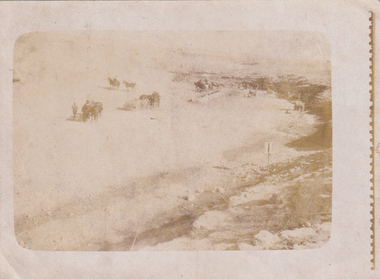
Photograph - Digital image, Charles Marshall et al, 3rd Light Horse Brigade watering area at Shellal, Palestine, 1917_
... 3rd Light Horse Brigade watering area at Shellal, Palestine...3rd Light Horse Brigade watering area at Shellal, Palestine..."3rd Brigade watering area Shellal Palestine"...Greensborough Historical Society 34A Glenauburn Road Lower Plenty Lower Plenty melbourne 3rd Light Horse Brigade watering area at Shellal, Palestine charles marshall world war 1 "3rd Brigade watering area Shellal Palestine" Digital copy of black and white photograph 3rd Light Horse Brigade watering area at Shellal, Palestine Photograph - Digital image Charles Marshall John Gibson ...3rd Light Horse Brigade watering area at Shellal, PalestineDigital copy of black and white photograph"3rd Brigade watering area Shellal Palestine"charles marshall, world war 1 -
 Emerald Museum & Nobelius Heritage Park
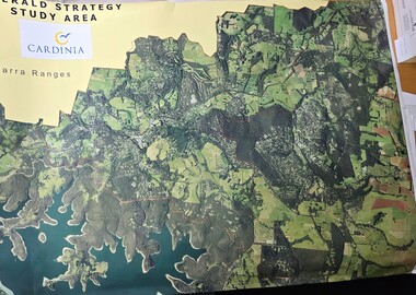
Map - Aerial Colour photographic map of Emerald township and surrounds, Emerald Strategy Study Area (Cardinia), unknown
... Emerald Strategy Study Area (Cardinia)...Aerial photograph of the Emerald township and surrounding area...Emerald Strategy Study Area/Cardinia/Yarra Ranges...Emerald Museum & Nobelius Heritage Park 5 Crichton Rd Emerald yarra-valley-and-the-dandenong-ranges Aerial photograph of the Emerald township and surrounding area Emerald Strategy Study Area/Cardinia/Yarra Ranges Image of aerial photograph of the Emerald township and surrounds Emerald Strategy Study Area (Cardinia) Map Aerial Colour photographic map of Emerald township and surrounds ...Aerial photograph of the Emerald township and surrounding areaImage of aerial photograph of the Emerald township and surroundsEmerald Strategy Study Area/Cardinia/Yarra Ranges -
 Warrnambool and District Historical Society Inc.
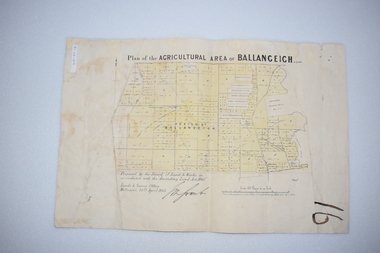
Original Document, Map: Agricultural area of Ballangeich 1865, 1865
... Map: Agricultural area of Ballangeich 1865...The previously larger runs which were mainly cattle and sheep based were now more open to closer settlement and a greater variety in farming.The lots range in size from approximately 50 acres to around 600 acres.Some areas are set aside for reserves. By 1886 the population of Ballangeich had grown to around 600 with an hotel, three state schools and a church.Tri weekly coaches ran to Colac, Warrnambool and Camperdown providing access to supplies mail and communication. ...Rectangular light card paper with black text showing allotments of land The area is coloured in green with scale at bottom right corner...At the top: Plan of the Agricultural area of Ballangeich 1865 At the bottom left: Prepared by the Board of Lands & Works in accordance with the Amending Land Act 1865 Lands & Survey Office Melbourne 13th April 1865. ...With signature Rectangular light card paper with black text showing allotments of land The area is coloured in green with scale at bottom right corner Map: Agricultural area of Ballangeich 1865 Original Document ...George Eddington arrived in Australia in 1839 and named and established property in 1841 calling the property Ballangeich after a Pass near his home town of Stirling in Scotland. It is situated 151 miles west of Melbourne and to the south of Mortlake and was originally part of the Mortlake shire, which was proclaimed 26th Jan 1864. Nearest streams are the Hopkins Riverand Lyall and Drysdale creek running through good agricultural land. This map relates to the breaking up of large runs which the Victorian government enabled through selection acts of the 1860's. The previously larger runs which were mainly cattle and sheep based were now more open to closer settlement and a greater variety in farming.The lots range in size from approximately 50 acres to around 600 acres.Some areas are set aside for reserves. By 1886 the population of Ballangeich had grown to around 600 with an hotel, three state schools and a church.Tri weekly coaches ran to Colac, Warrnambool and Camperdown providing access to supplies mail and communication. This map is typical of many which were produced in the 1860's in Victoria during a significant period of Victoria's and Warrnambool district history.Rectangular light card paper with black text showing allotments of land The area is coloured in green with scale at bottom right cornerAt the top: Plan of the Agricultural area of Ballangeich 1865 At the bottom left: Prepared by the Board of Lands & Works in accordance with the Amending Land Act 1865 Lands & Survey Office Melbourne 13th April 1865. With signaturehistory of warrnambool, ballangeich, land surveys victoria 1865, lands act 1865 victoria, ballangeich map 1865 -
 Stawell Historical Society Inc
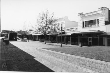
Photograph, Gold Reef Mall Stawell looking West from area in front of L.C. Langsford's Pharmacy
... Gold Reef Mall Stawell looking West from area in front of L.C. Langsford's Pharmacy....Gold Reef Mall Stawell looking West from area in front of L.C. Langsford's Pharmacy showing grassed area beside Wimmera Street intersection. ...Black and white photograph of building surrounding a paved area with raised lawn area and trees. ...Stawell Historical Society Inc 46 Longfield St Stawell grampians Gold Reef Mall Stawell looking West from area in front of L.C. Langsford's Pharmacy showing grassed area beside Wimmera Street intersection. ...Gold Reef Mall Stawell looking West from area in front of L.C. Langsford's Pharmacy showing grassed area beside Wimmera Street intersection. Post Office on right old Bank/Chemist building corner of Main and Wimmera Streets near centre and Town Hall in distance. c 1991Black and white photograph of building surrounding a paved area with raised lawn area and trees. stawell streetscape -
 Bendigo Military Museum
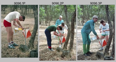
Photograph - Army Inter-area Orienteering Competition, Kimbolton State Forest, VIC, 1990
... Army Inter-area Orienteering Competition, Kimbolton State Forest, VIC...This set of 29 photographs was taken during Army’s Inter-area Orienteering competition held in the Kimbolton State Forest, near Lake Eppalock, Victoria in 1990. ...This set of 29 photographs was taken during Army’s Inter-area Orienteering competition held in Kimbolton State Forest, near Lake Eppalock, Victoria in 1990. ...There are no personnel identified. ‘Inter-Area Orienteering 1990’ annotated on negative sleeves...Bendigo Military Museum 37 - 39 Pall Mall Bendigo goldfields This set of 29 photographs was taken during Army’s Inter-area Orienteering competition held in the Kimbolton State Forest, near Lake Eppalock, Victoria in 1990. ...This set of 29 photographs was taken during Army’s Inter-area Orienteering competition held in the Kimbolton State Forest, near Lake Eppalock, Victoria in 1990. Teams from Albury-Wodonga Bendigo, Broadmeadows, Melbourne Metropolitan, Puckapunyal and Watsonia participated in the annual competition. Bendigo’s Army Survey Regiment led by SGT Mick Minchin hosted the Orienteering events. This set of 29 photographs was taken during Army’s Inter-area Orienteering competition held in Kimbolton State Forest, near Lake Eppalock, Victoria in 1990. The colour photographs are on 35mm negative film and were scanned at 2400 dpi. They are part of the Army Survey Regiment’s Collection. .1) to .4) - Photo, colour, 1990, unidentified competitors. .5) - Photo, colour, 1990, L to R: unidentified competitor, Bendigo’s Janet Murray. .6) - Photo, colour, 1990, L to R: unidentified official, Le-Anne (Smallshaw) Shirley, Bendigo’s Janet Murray, unidentified competitors (x2). .7) to .8) - Photo, colour, 1990, unidentified competitors. .9) - Photo, colour, 1990, L to R: unidentified official, Mick Minchin. .10) to .11) - Photo, colour, 1990, Mick Minchin. .12) to .13) - Photo, colour, 1990, Bendigo’s Team L to R: Rene van den Tol, Wolfgang Hofbauer, Mick Minchin, Harris Lee, unidentified competitor, Allan Blake, Janet Murray. .14) & .15) - Photo, colour, 1990, presentations L to R: Rene van den Tol, unidentified competitor. .16) to .19) - Photo, colour, 1990, unidentified competitors. .20) - Photo, colour, 1990, presentations L to R: Rene van den Tol, unidentified competitor. .21) - Photo, colour, 1990, presentations L to R: Rene van den Tol, unidentified competitor, Mick Minchin. .22) - Photo, colour, 1990, BBQ L to R: unidentified (x2), Jeff Rudd, Rene van den Tol, Mick Minchin, Neville Stone, Steve Cooper. .23) - Photo, colour, 1990, BBQ, Wolfgang Hofbauer. .24) - Photo, colour, 1990, BBQ, Janet Murray - in black jacket. .25) - Photo, colour, 1990, BBQ, all unidentified. .26) - Photo, colour, 1990, BBQ, Neville Stone - in green t-shirt, Rene van den Tol in red track suit, remainder unidentified. .27) - Photo, colour, 1990, BBQ L to R: unidentified (x4), Janet Murray, Le-Anne (Smallshaw) Shirley, remainder unidentified. .28) & .29) - Photo, colour, 1990, views of Lake Eppalock.There are no personnel identified. ‘Inter-Area Orienteering 1990’ annotated on negative sleevesroyal australian survey corps, rasvy, army survey regiment, army svy regt, fortuna -
 Bendigo Military Museum
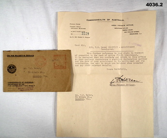
Document - DOCUMENT, PROMOTION, Area Finance Office, Dept of Air, 1-2-1946
... Davey's claim in respect of his promotion to Acting Flight Lieutenant. The Area Finance Officer requested details related to his claim. ...Area Finance Office, Dept of Air...Document DOCUMENT, PROMOTION Area Finance Office, Dept of Air ...Letter written in reply to F.G. Davey's claim in respect of his promotion to Acting Flight Lieutenant. The Area Finance Officer requested details related to his claim. Part of Frederick Gardner Davey DFC No. 410533 RAAF Collection. See Cat. No. 3536P for his service record.Typed letter on Commonwealth of Australia letterhead. Letter is contained in the brown paper envelope with postmark stamped in red. In place of a postage stamp is a red stamped mark..1) Address typed in black ink - "Mr F.G. Davey 86 Olinda St., Bendigo, Vic." Post marked in red ink - "Melbourne 1 Feb 46 Vic". .2) Date stamped in blue - "1-FEB 1946". Handwritten signature in black ink. rank, flight lieutenant, raaf -
 Stawell Historical Society Inc
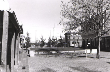
Photograph, Gold Reef Mall Stawell looking East from area in front of Post Office
... Gold Reef Mall Stawell looking East from area in front of Post Office. ...Gold Reef Mall Stawell looking East from area in front of Post Office. Showing lawn area of Mall near Wimmera Street on right. ...Black and white photograph of shops with a raised lawn area surrounded by paving....Stawell Historical Society Inc 46 Longfield St Stawell grampians Gold Reef Mall Stawell looking East from area in front of Post Office. Showing lawn area of Mall near Wimmera Street on right. ...Gold Reef Mall Stawell looking East from area in front of Post Office. Showing lawn area of Mall near Wimmera Street on right. L.C. Langsford's Pharmacy .Black and white photograph of shops with a raised lawn area surrounded by paving.stawell streetscape -
 University of Melbourne, Burnley Campus Archives
Photograph - Black and white print, Area Added in Late 1940's, Late 1940's
... Area Added in Late 1940's...The caption reads, "Area added to the garden in the late 1940's. ...Fenced and grassed area with Eucalypts around the perimeter....The caption reads, "Area added to the garden in the late 1940's. ...Appears as an illustration in, "Green Grows Our Garden," A.P. Winzenried p 87. The caption reads, "Area added to the garden in the late 1940's. First use of this area was for an apiary, and it is now a native garden."Black and white photograph. Fenced and grassed area with Eucalypts around the perimeter.On reverse, "Late 1940's."eucalypts, green grows our garden, a.p. winzenried, apiary, native garden, additional land -
 Ballarat Tramway Museum
Ephemera - Tour Notes, Victorian Railways et al, ARE/ARHS/AREA (Vintage Train) Tour to Ballarat, Sep. 1971
... ARE/ARHS/AREA (Vintage Train) Tour to Ballarat...... AREA...Set of three foolscap size sheets, for ARE/ARHS/AREA (Vintage Train) Tour to Ballarat, on Sunday 5 September 1971, the last day of the Mount Pleasant, Gardens Via St. ...Ballarat Tramway Museum South Gardens Reserve Wendouree Parade Ballarat Ballarat goldfields ARHS ARE AREA Ballarat Special Trains Notes on page 2 by W.Doubleday of trams operating and some notes. ...Set of three foolscap size sheets, for ARE/ARHS/AREA (Vintage Train) Tour to Ballarat, on Sunday 5 September 1971, the last day of the Mount Pleasant, Gardens Via St. West Lines. 1. - Welcome Aboard circular - printed both sides on pink paper - which involved the running of two trains, special bus and tram arrangements at Ballarat, for the visit to Sovereign Hill. Gives details of the tram timetables, for the afternoon, train departure times, lunch arrangements and notes on bus and tram running if peak loads encountered. 2nd copy ex Peter Winspur, added 11/1/2007. 2. Victorian Railways S Circular, or special train notice, S2188/71, three pages giving list of special trains, altered platform arrangements at Flinders St., train schedules, alterations to goods trains, light engine movements, loads, motive power and tickets. Signed by J.C. Crute as Chief Traffic Manager. Dated 27/8/1971. See Reg Item 3442 for the booking circular and form. Images of document added 27-08-12.Notes on page 2 by W.Doubleday of trams operating and some notes.arhs, are, area, ballarat, special trains -
 Vision Australia
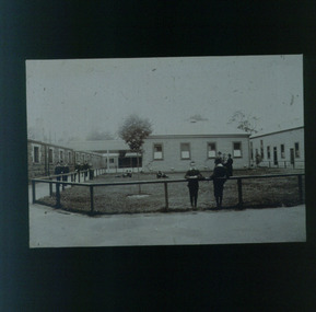
Slide - Image, Recreation area at RVIB
... Recreation area at RVIB...Image of boys and men around and in a grassed area at RVIB, that is bordered by wooden railing. ...Boys and men standing behind or by a fence bordering a grassed area...Some children rest on the railing whilst others play in the grass or walk around the area. Three adults talk amongst the boys. Education Royal Victorian Institute for the Blind Boys and men standing behind or by a fence bordering a grassed area Recreation area at RVIB Slide Image Nicholas Caire ...Image of boys and men around and in a grassed area at RVIB, that is bordered by wooden railing. A single-storey bluestone building and two wooden buildings surround the grass. Some children rest on the railing whilst others play in the grass or walk around the area. Three adults talk amongst the boys. Boys and men standing behind or by a fence bordering a grassed areaeducation, royal victorian institute for the blind -
 Ringwood and District Historical Society
Map, Department of Mines, Plan of area applied for under the mining leases regulations in the township of Ringwood between Maroondah Highway and Mt. Dandenong Road. Mining District of Castlemaine, County of Mornington, Parish of Ringwood T Area 58(A) 2 (R)15(P) Acres, Roods, Perches. 1934, 20-Feb-34
... Plan of area applied for under the mining leases regulations in the township of Ringwood between Maroondah Highway and Mt. ...Dandenong Road. the area applied for on lease No.8210 by E.G.Browne.Mining District of Castlemaine, County of Mornington, Parish of Ringwood T Area 58(A) 2 (R)15(P) Acres, Roods, Perches....Mining District of Castlemaine, County of Mornington, Parish of Ringwood T Area 58(A) 2 (R)15(P) Acres, Roods, Perches +Additional Keywords: Browne E.G....Dandenong Road. the area applied for on lease No.8210 by E.G.Browne.Mining District of Castlemaine, County of Mornington, Parish of Ringwood T Area 58(A) 2 (R)15(P) Acres, Roods, Perches. ...Map of the township of Ringwood with subdivisions between Maroondah Highway and Mt. Dandenong Road. the area applied for on lease No.8210 by E.G.Browne.Mining District of Castlemaine, County of Mornington, Parish of Ringwood T Area 58(A) 2 (R)15(P) Acres, Roods, Perches.Buff coloured sheet foolscap with black printing showing map of the township of Ringwood between Maroondah Highway and Mt. Dandenong Road. Mining District of Castlemaine, County of Mornington, Parish of Ringwood T Area 58(A) 2 (R)15(P) Acres, Roods, Perches +Additional Keywords: Browne E.G. -
 Greensborough Historical Society
Document, Commonwealth War Graves Commission. [Greensborough area], 1917-1945
... Commonwealth War Graves Commission. [Greensborough area]...A list of residents from the Greensborough area who died on active service and whose graves are recorded on the Commonwealth War Graves Commission website (www.cwgc.org). ...2 page printout of names of war dead from the Greensborough area....Greensborough Historical Society 34A Glenauburn Road Lower Plenty Lower Plenty melbourne A list of residents from the Greensborough area who died on active service and whose graves are recorded on the Commonwealth War Graves Commission website (www.cwgc.org). ...A list of residents from the Greensborough area who died on active service and whose graves are recorded on the Commonwealth War Graves Commission website (www.cwgc.org). Includes Greensborough, Watsonia, Lower Plenty, Montmorency, Bundoora and Macleod.2 page printout of names of war dead from the Greensborough area.Hand written on page "For complete details see electronic copy on Victorian collections"commonwealth war graves commission, world war 1, world war 2, greensborough, watsonia, lower plenty, montmorency, bundoora, macleod -
 Melbourne Tram Museum
Document - Report, Melbourne & Metropolitan Tramways Board (MMTB), 'Current trends which may indicate the future growth and nature of the metropolitan area and in particular the Central Business area of Melbourne", Jan. 1966
... 'Current trends which may indicate the future growth and nature of the metropolitan area and in particular the Central Business area of Melbourne"...Report - Foolscap, card covers, red binding strip, about pages + drawings or charts, titled 'Current trends which may indicate the future growth and nature of the metropolitan area and in particular the Central Business area of Melbourne" Has three parts: 1 - Future growth of population of the Melbourne Metropolitan Area 2 - The Centre of Gravity of and general distribution of the Central Business area of Melbourne 3 - Future growth of the Central Business Area of Melbourne. ...Report - Foolscap, card covers, red binding strip, about pages + drawings or charts, titled 'Current trends which may indicate the future growth and nature of the metropolitan area and in particular the Central Business area of Melbourne" Has three parts: 1 - Future growth of population of the Melbourne Metropolitan Area 2 - The Centre of Gravity of and general distribution of the Central Business area of Melbourne 3 - Future growth of the Central Business Area of Melbourne. ...Report - Foolscap, card covers, red binding strip, about pages + drawings or charts, titled 'Current trends which may indicate the future growth and nature of the metropolitan area and in particular the Central Business area of Melbourne" Has three parts: 1 - Future growth of population of the Melbourne Metropolitan Area 2 - The Centre of Gravity of and general distribution of the Central Business area of Melbourne 3 - Future growth of the Central Business Area of Melbourne. Dated Jan 1966, prior to the construction of the Underground Railway and the move to Docklands.Has "JEC" in pencil on top right hand corner.trams, tramways, melbourne, planning, development -
 Stawell Historical Society Inc
Photograph, Don Rickard, Cobb & Co Staging Area, Armstrong, c1990's
... Cobb & Co Staging Area, Armstrong...Cobb & Co Staging Area Armstrong next to Post Office, Low Building is site of Stables Since Rebuilt (Storm Damage) and clad in Flattened Steel Sheets....Colour photograph of Staging Area next to Post Office, Partly Hidden Behind trees ...Colour photograph of Staging Area next to Post Office, Partly Hidden Behind trees Cobb & Co Staging Area, Armstrong Photograph Don Rickard ...Cobb & Co Staging Area Armstrong next to Post Office, Low Building is site of Stables Since Rebuilt (Storm Damage) and clad in Flattened Steel Sheets.Colour photograph of Staging Area next to Post Office, Partly Hidden Behind trees -
 Falls Creek Historical Society
Plan - Leases of part of Falls Creek Tourist Area
... Leases of part of Falls Creek Tourist Area...It is a large Surveyor's Plan of a section of the Falls Creek Tourist Area. It is endorsed by J Parker, Chief Surveyor of the State Electricity Commission of Victoria on 27-3-84. ...Heading - PART OF FALLS CREEK TOURIST AREA PART OF CROWN ALLOTMENT 1 PARISH OF CARRUNO PART OF CROWN ALLOTMENT 1 PARISH OF DARBALANG COUNTY OF BOGONG...Leases of part of Falls Creek Tourist Area Plan Leases of part of Falls Creek Tourist Area ...Bob (Herman) Hymans (a former member of the Royal Netherlands Navy was born in Bloemendaal, Holland on 30th September 1922. During World War II he fought against the Japanese in the Dutch East Indies (now Indonesia) and was imprisoned in Changi and on the Burma Railway. After gaining qualifications as a Ski Instructor, Bob arrived in Falls Creek in May 1950. Working as an Instructor and Supervisor at Bogong Lodge, Bob decided his future was in accommodation. He was successful in negotiating an indenture for land from the State Electricity Commission (SEC). It took Bob two years to build his Grande Coeur Chalet but, tragically, it was burned down in August 1961. Bob also built the first Chairlift in Australia. This was a single chairlift and the structure was built from wooden electricity poles. He was constantly full of new ideas and proposals for the village. Bob Hymans died on 7th May 2007. This Collection of documents and letters tells the story of Bob’s endeavours to develop Falls Creek into the ski village it is today. This map is significant because it documents boundaries of early leases in Falls Creek Tourist Area.This map is part of Bob Hymans documents. It is a large Surveyor's Plan of a section of the Falls Creek Tourist Area. It is endorsed by J Parker, Chief Surveyor of the State Electricity Commission of Victoria on 27-3-84. It shows streets, lot numbers and measurements. It was a compilation created from existing lease maps. Heading - PART OF FALLS CREEK TOURIST AREA PART OF CROWN ALLOTMENT 1 PARISH OF CARRUNO PART OF CROWN ALLOTMENT 1 PARISH OF DARBALANG COUNTY OF BOGONGmap of falls creek, falls creek leases, falls creek 1980s -
 National Vietnam Veterans Museum (NVVM)
Photograph - In a Black Frame are Three Coloured Photographs, Overlooking Peter Badcoe Club and Pool, Looking Along Beach Road and Huey Leaving Vampire Pad From RAASC Vehicle Area, (1962 - 1973)
... Overlooking Peter Badcoe Club and Pool, Looking Along Beach Road and Huey Leaving Vampire Pad From RAASC Vehicle Area ...The bottom photograph shows a Huey leaving vampire pad RAASC vehicle Area...View of Facilities - Peter Badcoe Club and Pool 2. 2 AOD Looking along Beach Road. 3.Huey leaving Vampire pad - RAASC vehicle Area...The bottom photograph shows a Huey leaving vampire pad RAASC vehicle Area Overlooking Peter Badcoe Club and Pool, Looking Along Beach Road and Huey Leaving Vampire Pad From RAASC Vehicle Area Photograph In a Black Frame are Three Coloured Photographs ...In a black frame are three coloured photographs with white matt. The top photograph shows a view Overlooking Peter Badcoe Club and Pool. The middle photograph of 2 AOD - Looking along Beach Road. The bottom photograph shows a Huey leaving vampire pad RAASC vehicle Area1. View of Facilities - Peter Badcoe Club and Pool 2. 2 AOD Looking along Beach Road. 3.Huey leaving Vampire pad - RAASC vehicle Areapeter badcoe club (vung tau, vietnam), hueycobra (helicopter), photograph, 2 aod -
Marysville & District Historical Society
Ephemera (Item) - Information brochure, Artworkz Tourism, MARYSVILLE-ANDERSON MILL CAMP AREA, 26-03-2016
... MARYSVILLE-ANDERSON MILL CAMP AREA...An information brochure on the Anderson Mill camp area near Marysville. This brochure was produced by Artworkz Tourism in March 2016....An information brochure on the Anderson Mill camp area near Marysville. This brochure was produced by Artworkz Tourism in March 2016....MARYSVILLE-ANDERSON MILL CAMP AREA Ephemera Information brochure Artworkz Tourism ...An information brochure on the Anderson Mill camp area near Marysville. This brochure was produced by Artworkz Tourism in March 2016.An information brochure on the Anderson Mill camp area near Marysville.Disclaimer: The authors have taken care to ensure this/ publication is correct, though please be aware that/ errors and omissions do occur.marysville, victoria, australia, information brochure, artworkz tourism, anderson mill camp area, anderson mill -
Marysville & District Historical Society
Ephemera (Item) - Information brochure, Artworkz Tourism, MARYSVILLE-KEPPEL CREEK CAMP AREA, 26-03-2016
... MARYSVILLE-KEPPEL CREEK CAMP AREA...An information brochure on the Keppel Creek camp area near Marysville. This brochure was produced by Artworkz Tourism in March 2016....An information brochure on the Keppel Creek camp area near Marysville. This brochure was produced by Artworkz Tourism in March 2016....An information brochure on the Keppel Creek camp area near Marysville. marysville victoria australia information brochure artworkz tourism keppel creek camp area keppel creek day visitor area Disclaimer: The authors have taken care to ensure this/ publication is correct, though please be aware that/ errors and omissions do occur. ...An information brochure on the Keppel Creek camp area near Marysville. This brochure was produced by Artworkz Tourism in March 2016.An information brochure on the Keppel Creek camp area near Marysville.Disclaimer: The authors have taken care to ensure this/ publication is correct, though please be aware that/ errors and omissions do occur.marysville, victoria, australia, information brochure, artworkz tourism, keppel creek camp area, keppel creek day visitor area -
 Stawell Historical Society Inc
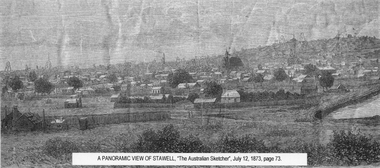
Drawing, Town & Big Hill from King Street area -- Sketch
... Town & Big Hill from King Street area -- Sketch...Town & Big Hill from King Street area...Black and White sketch drawn from King Street area St Patrick's church just right of centre. ...Stawell Historical Society Inc 46 Longfield St Stawell grampians Town & Big Hill from King Street area stawell A Panoramic View of Stawell Black and White sketch drawn from King Street area St Patrick's church just right of centre. ...Town & Big Hill from King Street areaBlack and White sketch drawn from King Street area St Patrick's church just right of centre. Poppet heads on skyline. A Panoramic View of Stawellstawell -
Clunes Museum
Map, DJA DJA WARRUNG RECOGNITION AND SETTLEMENT AGREEMENT AREA, 2013
... DJA DJA WARRUNG RECOGNITION AND SETTLEMENT AGREEMENT AREA...MAP DJA DJA WURRUNG RECOGNITION AND SETTLEMENT AGREEMENT AREA...SHOWING THE DJA DJA WURRUNG RECOGNITION AND SETTLEMENT AGREEMENT AREA SUBJECT TO RECOGNITION AND SETTMENT AGREEMENT 2013...Clunes Museum 36 Fraser Street enter building through Collins Place Clunes goldfields MAP DJA DJA WURRUNG RECOGNITION AND SETTLEMENT AGREEMENT AREA DJA DJA WURRUNG MAP OF RECOGNITION AREA COLOUR PRINTED MAP LAMINATED. ...MAP DJA DJA WURRUNG RECOGNITION AND SETTLEMENT AGREEMENT AREACOLOUR PRINTED MAP LAMINATED. SHOWING THE DJA DJA WURRUNG RECOGNITION AND SETTLEMENT AGREEMENT AREA SUBJECT TO RECOGNITION AND SETTMENT AGREEMENT 2013dja dja wurrung, map of recognition area -
Marysville & District Historical Society
Ephemera (Item) - Information brochure, Artworkz Tourism, MARYSVILLE-YELLOW DOG DAY VISITOR AREA, 23-04-2018
... MARYSVILLE-YELLOW DOG DAY VISITOR AREA...An information brochure on the Yellow Dog Day Visitor Area near Marysville. This brochure was produced by Artworkz Tourism in April 2018....An information brochure on the Yellow Dog Day Visitor Area near Marysville. This brochure was produced by Artworkz Tourism in April 2018....MARYSVILLE-YELLOW DOG DAY VISITOR AREA Ephemera Information brochure Artworkz Tourism ...An information brochure on the Yellow Dog Day Visitor Area near Marysville. This brochure was produced by Artworkz Tourism in April 2018.An information brochure on the Yellow Dog Day Visitor Area near Marysville.Disclaimer: The authors have taken care to ensure this/ publication is correct, though please be aware that/ errors and omissions do occur.marysville, victoria, australia, information brochure, artworkz tourism, yellow dog day visitor area -
 Buninyong Visitor Information Centre
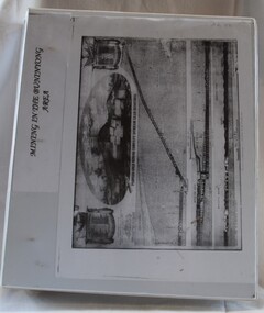
Document (item) - Folio, Buninyong Visitor Information Centre Volunteers, Mining in the Buninyong Area, 1990s
... Mining in the Buninyong Area...Includes names of mining companies in the area and maps showing locations of mines. ...Includes 29 maps, tables and notes on mining in the Buninyong area....Includes 29 maps, tables and notes on mining in the Buninyong area. Mining in the Buninyong Area Document Folio Buninyong Visitor Information Centre Volunteers ...Includes names of mining companies in the area and maps showing locations of mines. mining, gold mining, buninyong, industry -
 University of Melbourne, Burnley Campus Archives
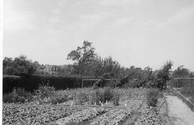
Photograph - Black and white print, Nursery Area of Orchard, Unknown
... Nursery Area of Orchard...Littlejohn, "Nursery area. Note Cordon pears on Orchard fence. Gladiolus trials, Boxthorn hedge."...Black and white photograph. Nursery area. Note Cordon pears on Orchard fence. Gladiolus trials. ...Nursery area. Note Cordon pears on Orchard fence. Gladiolus trials. ...Note by E.B. Littlejohn, "Nursery area. Note Cordon pears on Orchard fence. Gladiolus trials, Boxthorn hedge."Black and white photograph. Nursery area. Note Cordon pears on Orchard fence. Gladiolus trials. Boxthorn hedge.(E. B. Littlejohn)nursery, pears, orchard, gladiolus, boxthorn hedge, cordon -
 Wangaratta RSL Sub Branch
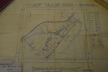
Work on paper - Field Sketch, Camp Kilo 89 Area
... Camp Kilo 89 Area...It served primarily as a major training site, staging area, and base for Australian units. Hand sketch of 'Kilo 89' Camp, located in collection of assorted Army issue books and personal papers belonging to Private Alfred William VONARX VX29295 who was born 5/7/1901 at Docker Plains near Wangaratta. ...Camp Kilo 89 Area - Field Sketch Handwritten on rear - Pte B G HOY...Detailed field sketch to scale of Camp Kilo 89 Area, Gaza Ridge in Palestine camp kilo 89 palestine ww2 alfred william vonarx brian goodwin hoy 2/7 infantry battalion Camp Kilo 89 Area - Field Sketch Handwritten on rear - Pte B G HOY Detailed sketch to scale on cream coloured parchment Camp Kilo 89 Area Work on paper Field Sketch ...Kilo 89 Camp was a significant Australian Imperial Force (AIF) military base in Southern Palestine (near Gaza) during World War II, operational around 1940–1943. It served primarily as a major training site, staging area, and base for Australian units. Hand sketch of 'Kilo 89' Camp, located in collection of assorted Army issue books and personal papers belonging to Private Alfred William VONARX VX29295 who was born 5/7/1901 at Docker Plains near Wangaratta. He enlisted on the 4/7/1940 at Seymour and served with the 2/7th Battalion in the Middle East during WW2. Written on back of sketch is - Pte B G HOY - Brian Goodwin HOY VX44031 born 20/4/1915 at Alphington.Detailed field sketch to scale of Camp Kilo 89 Area, Gaza Ridge in PalestineDetailed sketch to scale on cream coloured parchmentCamp Kilo 89 Area - Field Sketch Handwritten on rear - Pte B G HOYcamp kilo 89, palestine, ww2, alfred william vonarx, brian goodwin hoy, 2/7 infantry battalion