Showing 51 items matching "arthurs creek road bridge"
-
 Eltham District Historical Society Inc
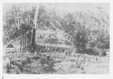
Work on paper (Sub-Item) - Photograph, Arthurs Creek Road Bridge, Hurstbridge, 1885
... Arthurs Creek Road Bridge, Hurstbridge, 1885...Eltham District Historical Society Inc 728 Main Rd Eltham melbourne Black and white photograph. bridge Hurstbridge Image printed on A4 page from 04997 Diamond Creek Basin Study, 1980 Arthurs Creek Road Bridge, Hurstbridge, 1885 Work on paper Photograph ...Black and white photograph.bridge, hurstbridge -
 Eltham District Historical Society Inc
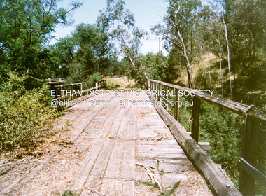
Negative - Photograph, Russell Yeoman, Linton's bridge over Arthurs Creek, Nutfield, c.1970
... arthurs creek...arthurs creek road...Bridge...Eltham District Historical Society Inc 728 Main Rd Eltham melbourne arthurs creek arthurs creek road Bridge Linton's Bridge Ilford HP4 Roll of 35mm black and white negative film, 4 of 7 strips and corresponding B&W print Linton's bridge over Arthurs Creek, Nutfield Negative Photograph Russell Yeoman ...Roll of 35mm black and white negative film, 4 of 7 strips and corresponding B&W printIlford HP4arthurs creek, arthurs creek road, bridge, linton's bridge -
 Eltham District Historical Society Inc
Negative - Photograph, J.A. McDonald, Hurstbridge-Arthurs Creek Road, Aug. 1960
... Hurstbridge-Arthurs Creek Road...bridge...bridge and road reconstruction projects, sometimes with Eltham Shire Council Project Reference numbers quoted. It was during this period that a number of significant improvements were made to roads and new bridges constructed within the shire that remain in place as of present day (2022). In many situations, the photos provide a tangible visible record of infrastructure that existed throughout the early days of the Shire. The album was put together by or under the direction of the Shire Engineer, J.A. McDonald. Infrastructure shire of eltham 1960-08 A. Gillies F. Wood G. Blair Hurstbridge-Arthurs Creek ...Laying culverts on boards A. Gillies, F. Wood, G. BlairRecord of various Shire of Eltham infrastructure works undertaken during the period of 1952-1962 involving bridge and road reconstruction projects, sometimes with Eltham Shire Council Project Reference numbers quoted. It was during this period that a number of significant improvements were made to roads and new bridges constructed within the shire that remain in place as of present day (2022). In many situations, the photos provide a tangible visible record of infrastructure that existed throughout the early days of the Shire. The album was put together by or under the direction of the Shire Engineer, J.A. McDonald.infrastructure, shire of eltham, 1960-08, a. gillies, f. wood, g. blair, hurstbridge-arthurs creek road, bridge construction, road construction -
 Eltham District Historical Society Inc
Negative - Photograph, J.A. McDonald, Hurstbridge-Arthurs Creek Road, Aug. 1960
... Hurstbridge-Arthurs Creek Road...bridge...bridge and road reconstruction projects, sometimes with Eltham Shire Council Project Reference numbers quoted. It was during this period that a number of significant improvements were made to roads and new bridges constructed within the shire that remain in place as of present day (2022). In many situations, the photos provide a tangible visible record of infrastructure that existed throughout the early days of the Shire. The album was put together by or under the direction of the Shire Engineer, J.A. McDonald. Infrastructure shire of eltham 1960-08 Hurstbridge-Arthurs Creek ...Culvert at Patullo’s CA 34H1 Sec. B, Parish of Greensborough F. Wood Drott and truck Council crane August 1960Record of various Shire of Eltham infrastructure works undertaken during the period of 1952-1962 involving bridge and road reconstruction projects, sometimes with Eltham Shire Council Project Reference numbers quoted. It was during this period that a number of significant improvements were made to roads and new bridges constructed within the shire that remain in place as of present day (2022). In many situations, the photos provide a tangible visible record of infrastructure that existed throughout the early days of the Shire. The album was put together by or under the direction of the Shire Engineer, J.A. McDonald.infrastructure, shire of eltham, 1960-08, hurstbridge-arthurs creek road, bridge construction, bulldozer, cranes, drott, road construction -
 Eltham District Historical Society Inc
Book, Diamond Creek Basin Study. Part 1, A Compendium of Factors Relevant to Stormwater Flows, 1980
... arthurs creek mine...arthurs creek road bridge...Eltham District Historical Society Inc 728 Main Rd Eltham melbourne Basin Studies are studies to evaluate water supply and demand and help ensure reliable water supplies by identifying strategies to address imbalances in water supply and demand. aerial photographs allendale road arthurs creek mine arthurs creek road bridge arthurs creek bald spur look-out bank protection bolton steet bridge street bridge bridge street bridges challenger street chute street construction coolaroo drive culvert deep creek diamond creek basin diamond creek region diamond creek diamond street bridge drainage works eltham lower park eltham town park eltham trestle bridge eltham west drains eltham erosion flood management floods footbridge glen katherine estate gold mining gum glade hurstbridge kangaroo ground kinglake escarpment kinglake national park latiners hat factory main road bridge main road masons falls melbourne metropolitan board of works, monash bridge mount sugarloaf nillumbik park orchards railway culvert railway line ramptons road real estate advertisement research creek st helena east drain st helena road st helena storm sewers stormwater sugarloaf-preston transfer main crossing susan street union mine village pond water flow watkins street wattletree road weidlich road wingrove park yarra river zig zag road water supply basin study Spiral Bound. 157 leaves in various foliations (some folded) : illustrated. ...Basin Studies are studies to evaluate water supply and demand and help ensure reliable water supplies by identifying strategies to address imbalances in water supply and demand.Spiral Bound. 157 leaves in various foliations (some folded) : illustrated. (some colour.), maps (some colour.)aerial photographs, allendale road, arthurs creek mine, arthurs creek road bridge, arthurs creek, bald spur look-out, bank protection, bolton steet, bridge street bridge, bridge street, bridges, challenger street, chute street, construction, coolaroo drive, culvert, deep creek, diamond creek basin, diamond creek region, diamond creek, diamond street bridge, drainage works, eltham lower park, eltham town park, eltham trestle bridge, eltham west drains, eltham, erosion, flood management, floods, footbridge, glen katherine estate, gold mining, gum glade, hurstbridge, kangaroo ground, kinglake escarpment, kinglake national park, latiners hat factory, main road bridge, main road, masons falls, melbourne metropolitan board of works, monash bridge, mount sugarloaf, nillumbik park, orchards, railway culvert, railway line, ramptons road, real estate advertisement, research creek, st helena east drain, st helena road, st helena, storm sewers, stormwater, sugarloaf-preston transfer main crossing, susan street, union mine, village pond, water flow, watkins street, wattletree road, weidlich road, wingrove park, yarra river, zig zag road, water supply, basin study -
 Eltham District Historical Society Inc
Slide, Monash Bridge, Hurstbridge-Arthurs Creek Road, Hurstbridge, c.1975, 1975c
... Hurstbridge, Hurstbridge-Arthurs Creek Road, Monash Bridge...Eltham District Historical Society Inc 728 Main Rd Eltham melbourne Hurstbridge, Hurstbridge-Arthurs Creek Road, Monash Bridge 35 mm colour positive transparency Mount - Agfacolor Service (Blue) Monash Bridge, Hurstbridge-Arthurs Creek Road, Hurstbridge, c.1975 Slide ...35 mm colour positive transparency Mount - Agfacolor Service (Blue)hurstbridge, hurstbridge-arthurs creek road, monash bridge -
 Eltham District Historical Society Inc
Slide, Monash Bridge, Hurstbridge-Arthurs Creek Road, Hurstbridge, c.1975, 1975c
... hurstbridge, hurstbridge-arthurs creek road, monash bridge...Eltham District Historical Society Inc 728 Main Rd Eltham melbourne hurstbridge, hurstbridge-arthurs creek road, monash bridge 35 mm colour positive transparency Mount - Agfacolor Service (Blue) Monash Bridge, Hurstbridge-Arthurs Creek Road, Hurstbridge, c.1975 Slide ...35 mm colour positive transparency Mount - Agfacolor Service (Blue)hurstbridge, hurstbridge-arthurs creek road, monash bridge -
 Eltham District Historical Society Inc
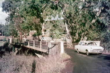
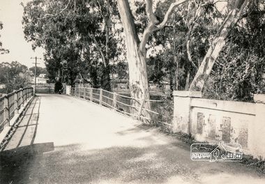
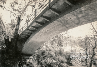
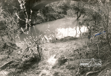
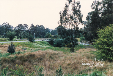
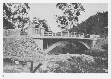
Photograph, Monash Bridge, Hurstbridge-Arthurs Creek Road, Hurstbridge
... Hurstbridge Arthurs Creek Road...Monash Bridge...Eltham District Historical Society Inc 728 Main Rd Eltham melbourne infrastructure shire of eltham infrastructure bridge Arched Bridge Hurstbridge Hurstbridge Arthurs Creek Road Monash Bridge Black and white photograph Monash Bridge, Hurstbridge-Arthurs Creek Road, Hurstbridge Photograph ...Black and white photographinfrastructure, shire of eltham infrastructure, bridge, arched bridge, hurstbridge, hurstbridge arthurs creek road, monash bridge -
 Eltham District Historical Society Inc
Photograph, Monash Bridge, Hurstbridge-Arthurs Creek Road, Hurstbridge
... hurstbridge arthurs creek road...monash bridge...Eltham District Historical Society Inc 728 Main Rd Eltham melbourne infrastructure shire of eltham infrastructure bridge arched bridge hurstbridge hurstbridge arthurs creek road monash bridge Black and white photograph Monash Bridge, Hurstbridge-Arthurs Creek Road, Hurstbridge Photograph ...Black and white photographinfrastructure, shire of eltham infrastructure, bridge, arched bridge, hurstbridge, hurstbridge arthurs creek road, monash bridge -
 Eltham District Historical Society Inc
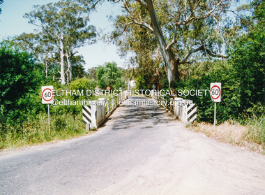
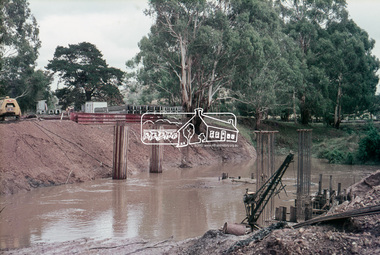
Photograph, Doug Orford, Monash Bridge across Diamond Creek, Hurstbridge - Arthurs Creek Road, Hurstbridge, 1991, 1991
... arthurs creek road...hurstbridge...monash bridge...Eltham District Historical Society Inc 728 Main Rd Eltham melbourne From a collection of 35 photos taken by Doug Orford at 35 specific locations along the exact boundary of the then Shire of Eltham. bridges diamond creek hurstbridge - arthurs creek road hurstbridge monash bridge Colour photograph Monash Bridge across Diamond Creek, Hurstbridge - Arthurs Creek Road, Hurstbridge, 1991 Photograph Photograph Doug Orford ...From a collection of 35 photos taken by Doug Orford at 35 specific locations along the exact boundary of the then Shire of Eltham.Colour photographbridges, diamond creek, hurstbridge - arthurs creek road, hurstbridge, monash bridge -
 Eltham District Historical Society Inc
Photograph, Doug Orford, Burkes Bridge across Arthurs Creek, Hurstbridge - Arthurs Creek Road, Hurstbridge, 1991, 1991
... arthurs creek road...hurstbridge...burkes bridge...Eltham District Historical Society Inc 728 Main Rd Eltham melbourne From a collection of 35 photos taken by Doug Orford at 35 specific locations along the exact boundary of the then Shire of Eltham. bridges hurstbridge - arthurs creek road hurstbridge burkes bridge arthurs creek Colour photograph Burkes Bridge across Arthurs Creek, Hurstbridge - Arthurs Creek Road, Hurstbridge, 1991 Photograph Photograph Doug Orford ...From a collection of 35 photos taken by Doug Orford at 35 specific locations along the exact boundary of the then Shire of Eltham.Colour photographbridges, hurstbridge - arthurs creek road, hurstbridge, burkes bridge, arthurs creek -
 Eltham District Historical Society Inc
Photograph, Doug Orford, The old Burkes Bridge across Arthurs Creek, Hurstbridge - Arthurs Creek Road, Hurstbridge, 1991, 1991
... arthurs creek road...hurstbridge...burkes bridge...Eltham District Historical Society Inc 728 Main Rd Eltham melbourne From a collection of 35 photos taken by Doug Orford at 35 specific locations along the exact boundary of the then Shire of Eltham. bridges hurstbridge - arthurs creek road hurstbridge burkes bridge arthurs creek Colour photograph The old Burkes Bridge across Arthurs Creek, Hurstbridge - Arthurs Creek Road, Hurstbridge, 1991 Photograph Photograph Doug Orford ...From a collection of 35 photos taken by Doug Orford at 35 specific locations along the exact boundary of the then Shire of Eltham.Colour photographbridges, hurstbridge - arthurs creek road, hurstbridge, burkes bridge, arthurs creek -
 Eltham District Historical Society Inc
Photograph, Monash Bridge, Arthurs Creek Road, Hurstbridge, Eltham Heritage Tour, 24 May 1992, 24/05/1992
... Highlights of the tour included: - 10 am Leave from Shire Offices - 3 Important Trees - A Physical Link to Eltham's First Settlers - Toorak Mansion Gates - A Surviving Farm House - An Intact Circa 1900 Main Street - First Settlers - Gold Miners, and Timber-getters - An Early Hotel - A Pioneering Homestead - Changing Eltham Shire - 20th Century - 4 pm Afternoon Tea and Finish Tour Extract from ELTHAM CULTURAL HERITAGE TOUR (Newsletter No. 85, July 1992, by Bettina Woodburn) "On the Arthurs Creek Road is a bridge designed by Monash, which we admired before walking across the little park with a mud-brick and timber shelter, to the Hurst family graveyard. ...Road through 'Aussie' bush of towering gums, with bracken and scrubby understorey, the Kinglake National Park, before more open country with deciduous trees planted in line, and a creek lined with willows." Record of the Society's history and activities and highlighting various aspects of the Heritage Study undertaken by David Bick used to create the future heritage overlay for the Shire of Eltham and later Nillumbik Shire. shire of eltham historical society activities heritage tour hurstbridge monash bridge arthurs creek road Kodak Gold 100 5095 Roll of 35mm colour negative film, 4 strips Monash Bridge, Arthurs Creek Road, Hurstbridge, Eltham Heritage Tour, 24 May 1992 Photograph ...ELTHAM HERITAGE TOUR The Society excursion on 24th May 1992 was arranged by David Bick, leader of the team carrying out the Shire's heritage study. David selected a number of sites or buildings identified in the study, some of them lesser known components of the Shire's heritage. The tour commenced at the Eltham Shire Office at 10.00 am. Travel was by private car and mini-bus with stops at about twelve locations for commentary by David.It included a short walk in Hurstbridge and lunch at Kinglake. Highlights of the tour included: - 10 am Leave from Shire Offices - 3 Important Trees - A Physical Link to Eltham's First Settlers - Toorak Mansion Gates - A Surviving Farm House - An Intact Circa 1900 Main Street - First Settlers - Gold Miners, and Timber-getters - An Early Hotel - A Pioneering Homestead - Changing Eltham Shire - 20th Century - 4 pm Afternoon Tea and Finish Tour Extract from ELTHAM CULTURAL HERITAGE TOUR (Newsletter No. 85, July 1992, by Bettina Woodburn) "On the Arthurs Creek Road is a bridge designed by Monash, which we admired before walking across the little park with a mud-brick and timber shelter, to the Hurst family graveyard. There are two marked graves, one, Henry who was shot by Burke the bushranger and a cairn has a plaque listing others buried here from 1866 onwards. Burke was captured and tied to the wheel of a dray under the eucalypt near the waterhose/standpipe. Close by the kindergarten, at this place are three trees on the National Trust Register, a Canary Island pine, a Canadian cedar and probably a spruce. Radiata pines and a thick bolled peppercorn surround the little cemetery. Continuing along Main Street we notice elm trees planted as a war memorial, then on the left a 1930 timber house, a 1910 store and residence, resplendent with wrought iron trim, a double fronted Hardware Store and cypresses on the back alignment of a new vacant block. On the right side of the street is a less interesting attempt at an 'in character' shop. Further on are more early homes, one tucked away at the rear with two tall palms by the front steps. Another curiosity is a rounded veranda corner and there are more galvanised iron sheds or garages, before a mud-brick Dentist's Surgery. Beyond the round-a-about is St Peters Church, of mud-brick construction shared by Catholic and Anglican parishioners, overlooking the river flood plain. Leaving Hurstbridge on the Kinglake Road, we ate our picnic lunch beside the communication tower and enjoyed views of Melbourne, Yan Yean Reservoir and the distant Dandenongs beyond the spreading suburbs. Next we drove to the North West boundary of the Shire at Masons Falls Road towards Whittlesea. On the way to the North East Boundary we passed St Peters, a yellow wooden Church with a Tudor Archway; built in the early 1920's in the style of the 1860's. From the Healesville-Kinglake road the rolling hills had European aspects, the hedged fields and chestnut trees. Then it was back down the Hurstbridge Road through 'Aussie' bush of towering gums, with bracken and scrubby understorey, the Kinglake National Park, before more open country with deciduous trees planted in line, and a creek lined with willows."Record of the Society's history and activities and highlighting various aspects of the Heritage Study undertaken by David Bick used to create the future heritage overlay for the Shire of Eltham and later Nillumbik Shire.Roll of 35mm colour negative film, 4 stripsKodak Gold 100 5095shire of eltham historical society, activities, heritage tour, hurstbridge, monash bridge, arthurs creek road -
 Upper Yarra Museum
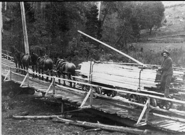
Negative Photographic Reproduction, Arthur Witnish's horse team hauling timber across bridge over Black Sands Creek, 14.2.1983
... Upper Yarra Museum Old Railway Station 2415C Warburton Highway Yarra Junction yarra-valley-and-dandenong-ranges bridge timber arthur witnish horse team tramway black sands creek timber truck gladysdale Black and white negative of Arthur Witnish's horse team hauling timber across bridge on Black Sands Road. ...Black and white negative of Arthur Witnish's horse team hauling timber across bridge on Black Sands Road. Negative Black white. Scanned at 600 dpibridge, timber, arthur witnish, horse team, tramway, black sands creek, timber truck, gladysdale -
 Eltham District Historical Society Inc
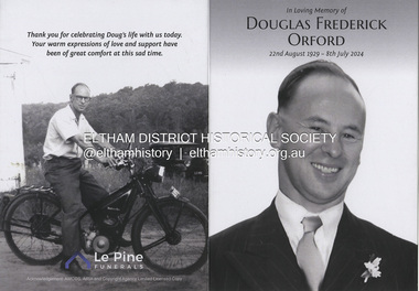
Document - Folder, Orford family
... Arthur Butler Young...Watsons Creek Victoria...Kangaroo Ground Victoria...Helen Logan...William Orford...Jane Orford...Arthur Orford...Frederick Orford...Florrie Orford...Victor Orford...Chem Orford...Sunnymede Eltham...Panton Hill Estate...Sir William Irvine...Gordon Lyons...Kate Thomas...North Eltham Gospel Church...Harold Clapp...Eltham Cricket Club...Research Primary School...Dalton Street School Eltham...Keith Banks...Betty Banks...Benjamine Boyd...Laughing Waters Road Eltham...Freddie Gilsinen...Douglas Frederick Orford...Eltham District Historical Society...Funeral Service...Le Pine Funeral Home...Life Member...Order of Service...1934 Flood...1939 bushfires...Alcock & Pierce...Ansell...Associated Schools Sports...Blacksmith shop...Boakes...Bridge...New word file and associated pdf created [\Dropbox\EDHS DATA\DOCUMENTS\COLLECTION CATALOGUE DOCUMENTS AND PDFs\2-2 Family Folders\EDHS_06110-2 Doug Orford reminiscences 2002.docx - 1 April 2025] Doug Orford Eulogy by daughter Kathryn Whiteside 2024 and associated PDF [D:\Dropbox\EDHS DATA\DOCUMENTS\COLLECTION CATALOGUE DOCUMENTS AND PDFs\EDHS_06110 Doug Orford Obituary 2024.docx] Gwen Orford (nee Best) Eulogy 2025 and associated PDF [D:\Dropbox\EDHS DATA\DOCUMENTS\COLLECTION CATALOGUE DOCUMENTS AND PDFs\EDHS_06110 Gwen Orford (nee Best) Eulogy 2025.PDF] Doug Orford Harry Gilham Welcome Home Medal Eltham Avenue of Honour Nillumbik War Memorial Wingrove Park Henry Dendy Alfred Armstrong James Orford 264 Reynolds Road South Eltham George Orford George Joseph Orford Maryanne George Joseph Thomas Henry Orford Ernest Orford E F Orford Eltham Cemetery Helen Orford Joseph Panton Panton Park Gordon Lyon Banyule estate Heidelberg James Matthias Orford Wurundjeri Constable Peter Lawlor George Hill Franklin Street Eltham Ronald Orford Eltham Primary School John Brown Robert Gamble school inspector Sarah Orford Mary Ann Orford James Mathias Orford Sarah Amelia Orford James Peet Arthur Butler Young Watsons Creek Victoria Kangaroo Ground Victoria Helen Logan William Orford Jane Orford Arthur Orford Frederick Orford Florrie Orford Victor Orford Chem Orford Sunnymede Eltham Panton Hill Estate Sir William Irvine Gordon Lyons Kate Thomas North Eltham Gospel Church Harold Clapp Eltham Cricket Club Research Primary School Dalton Street School Eltham Keith Banks Betty Banks Benjamine Boyd Laughing Waters Road Eltham Freddie Gilsinen Douglas Frederick Orford Eltham District Historical Society Funeral Service Le Pine Funeral Home Life Member Order of Service 1934 Flood 1939 bushfires Alcock & Pierce Ansell Associated Schools Sports Blacksmith shop Boakes Bridge Street Bryce Family bullock track Butcher Catholic Church Cliff Lester Cliffy Green Daisy Smith Dave Lyon Diamond Creek Diana Bassett Smith Dick Tooth Dr. ...The Orford family, a pioneer family remained continuously living and working in Eltham for 170 years from 1854 to 2024. James and Sarah Orford arrived in Sydney in 1839 aboard the ship “Orestes”; they had several children there before settling in Eltham in 1854. Three children, James Mathias, Sarah Amelia and Thomas Henry initially remained in the Eltham area. James eventually moved to Brunswick. Sarah married Arthur Butler Young and finally lived in Bunyip. Thomas who was six years old when the family arrived in 1854 remained in Eltham, married Helen Logan who died, leaving a large family. They lived in a slab hut by the Yarra at Laughing Waters and Thomas managed the Panton Park Estate, a selection owned by Magistrate Thomas Panton. Thomas’s son, Ernest Orford was born 1892 at Pitt Street, Eltham and also lived his entire life in Eltham working as a labourer, orchardist and later as a gardener and grounds keeper for Sir William Irvine, a former Chief Justice and Premier of Victoria. Ernest married Kate Thomas; their two sons Ron and Doug stayed in the area. Another of Thomas' sons, Arthur, also lived in Eltham. Four Orford generations attended Eltham schools. Doug Orford was born on the kitchen table (reference, son Ted Orford) of the family home at the corner of Reynolds Road and Mount Pleasant Road. Doug married Gwen and they established a family however Gwen died at a young age from cancer. Doug eventually remarried another Gwen and they lived for several decades in Napoleon Street, Eltham. Doug was actively involved in EDHS over many years, including serving as a committee member and vice president. Contributions by Doug and Gwen (Treasurer/Membership Secretary), his wife, assisted EDHS to continue to develop as a not-for-profit group intent on promoting and preserving our local history. Both Doug and Gwen were made Life Members of EDHS. They also acted as EDHS delegates to the Eastern Region of Historical Societies. His significant work with assisting to establish our valued Local History Centre helped develop our home base and supported the continued growth of our society. Doug’s local knowledge, suggestions and family connections were highly valued, Until recent times, he continued to regularly attend our Collections Team workshops providing his insights and historical information about photographs and society records. Doug died peacefully July 8, 2024, and represents the last link in the Orford Eltham chain which spanned 170 years. His funeral was held Thursday, July 18, 2024, at Le Pine Funerals, 848 Main Road, Eltham. Contents: Typed notes, no date: Memories of Ernest Orford [taped 1979] about his school days. Handwritten notes, no date: History of Ernie Orford Typed notes, no date: History of Thomas Henry Orford and family. Photocopy: Shire of Eltham General Rate Receipts. Received from D Orford 7 June 1923 and Received from E F Orford, 4 August 1924. Letter, no date: Nillumbik Shire to Russell Yeoman, Gwen Orford to receive Volunteer Recognition Award. Newsletter article: "The Orford Family, Eltham", Shire of Eltham Historical Society, No.80 September 1991. History of Orford family. Handwritten notes: 21 March 2011, genealogy of George Orford. On reverse Melways map makred with Orford and other land ownerships. Newspaper advertisement, 21 March 2011: "264 Reynolds Road, South Eltham", property for sale [land in ownership of Orford family]. Letter: St Margaret's Anglican Church Eltham to Doug Orford, 17 November 2011, Extracts from church records relative to Orford family. Newspaper article: "Timely facelift at war memorials', Diamond Valley Leader, 30 April 2024, Nillumbik war memorial will have some work and a bronze plaque will be installed at the Eltham Avenue of Honour, Wingrove Park; photograph of Doug Orford Newsletter item: "Welcome home medal", Eltham District Historical Society newsletter no.216 May 2014, World War I two 'Welcome Home Medals' in ownership of local men, being Harry Gilham and Doug Orford. Order of Service, Le Pine Funerals (Eltham), In Loving Memory of Douglas Frederick Orford 22nd August 1929 - 8th July 2024 Doug Orford Reminiscences (2002) in conjunction with Jock Read and Peter Bassett Smith; 4 pages - 3 typed, 1 handwritten possibly transcribed from an audio tape recording (location unknown). New word file and associated pdf created [\Dropbox\EDHS DATA\DOCUMENTS\COLLECTION CATALOGUE DOCUMENTS AND PDFs\2-2 Family Folders\EDHS_06110-2 Doug Orford reminiscences 2002.docx - 1 April 2025] Doug Orford Eulogy by daughter Kathryn Whiteside 2024 and associated PDF [D:\Dropbox\EDHS DATA\DOCUMENTS\COLLECTION CATALOGUE DOCUMENTS AND PDFs\EDHS_06110 Doug Orford Obituary 2024.docx] Gwen Orford (nee Best) Eulogy 2025 and associated PDF [D:\Dropbox\EDHS DATA\DOCUMENTS\COLLECTION CATALOGUE DOCUMENTS AND PDFs\EDHS_06110 Gwen Orford (nee Best) Eulogy 2025.PDF]Newspaper clippings, A4 photocopies, etcdoug orford, harry gilham, welcome home medal, eltham avenue of honour, nillumbik war memorial, wingrove park, henry dendy, alfred armstrong, james orford, 264 reynolds road south eltham, george orford, george joseph orford, maryanne george joseph, thomas henry orford, ernest orford, e f orford, eltham cemetery, helen orford, joseph panton, panton park, gordon lyon, banyule estate heidelberg, james matthias orford, wurundjeri, constable peter lawlor, george hill, franklin street eltham, ronald orford, eltham primary school, john brown, robert gamble school inspector, sarah orford, mary ann orford, james mathias orford, sarah amelia orford, james peet, arthur butler young, watsons creek victoria, kangaroo ground victoria, helen logan, william orford, jane orford, arthur orford, frederick orford, florrie orford, victor orford, chem orford, sunnymede eltham, panton hill estate, sir william irvine, gordon lyons, kate thomas, north eltham gospel church, harold clapp, eltham cricket club, research primary school, dalton street school eltham, keith banks, betty banks, benjamine boyd, laughing waters road eltham, freddie gilsinen, douglas frederick orford, eltham district historical society, funeral service, le pine funeral home, life member, order of service, 1934 flood, 1939 bushfires, alcock & pierce, ansell, associated schools sports, blacksmith shop, boakes, bridge street, bryce family, bullock track, butcher, catholic church, cliff lester, cliffy green, daisy smith, dave lyon, diamond creek, diana bassett smith, dick tooth, dr. frank may, eltham higher elementary school, ernie andrew, fire station, flower stall, fodder business, fruit shop, furniture store, gahan family, garni burges, greensborough, harold norman, harry hawker, hat factory, hawker & owen, hay and com store, henry hawker, henry street, j .harry butherway, jack burgoyne, jack ryan, jock read, john lyon, junk yard, kevin gahan, kilpatricks, len parsons, lyon family, machine factory, mc leans, memorial, metery road, miss reynolds, monteith 's bus, mr. gadd, mrs. bird, mrs. morrison, napoleon street, peter bassett smith, peter's gahan, plenty river, plumridge, produce store, public hall, rechabite hall, reynolds road, roger bird, rutter family, ryan family, shoe factory., staffs produce store, studley cairn gahan, sweeneys lane, swimming pool, taylor street, tennis court, warren family, wooden bridge, yarra brae road -
 Eltham District Historical Society Inc
Document - Sharp family
... Gwen Sharp Sharp's Flat Hurstbridge Sharps Road Hurstbridge Arthurs Creek Hurstbridge Hurst Private Memorial Grave site Robert Hurst Frances Hurst Hurst's Bridge Ellen Hurst Keith Sharp Sheila Ferguson Henry Facey Hurst Charles Botterell Hawkins Fanny Hawkins nee Hurst Caroline Frances Maria Sharp nee Hawkins Robert Nehemiah Sharp "The Oaks" Kinglake William Sharp Edgar Sharp Harry Sharp Stan Sharp Daisy Sharp "Homeleigh" Hurstbridge Roy Sharp Jean Sharp Lilian Sharp Allwood House Hurstbridge Ferguson's Paddock Hurstbridge Arthur's Creek Road Carrie Sharp Sharps house Hurstbridge Dorset house Hurstbridge Ryans butcher Hurstbdirge Hortons bakery Hurstbridge Bootmaker Hurstbridge D G Graham blacksmith Hurstbridge Noella Macperson nee Sharp Richard Sharp Robert Sharp Muriel Sharp edna Sharp Lyn Sharp Muriel Sharp nee Limmer Muriel Willson Henry Willson Country Fire Authority Hurstbridge Newspaper clippings, A4 photocopies, etc Document Sharp family ...Keith Sharp was a descendant of the Hurst family, and lived in Hurstbridge, being active in the Hurstbridge Country Fire Authority. His family's farm gave its name to Sharps road, Hurstbridge. Contents Gwen Sharp, no date: Photocopy of collection of material on Sharp family of Hurstbridge and naming of Sharps Road containing: Photograph Fergusen's paddock, Hurstbridge, 1987. Notes on renaming of Sharp's Flat to Sharps Road. Notes on the Hurst family and how Keith Sharp is descended from Ellen Hurst, with details of each generation. Photographs of Sharp family and of Hurstbridge. Photograph of Allwood House, 1899, including W G Gray, Carrie Sharp and Robert Sharp. Newspaper clippings, A4 photocopies, etcgwen sharp, sharp's flat hurstbridge, sharps road hurstbridge, arthurs creek, hurstbridge, hurst private memorial grave site, robert hurst, frances hurst, hurst's bridge, ellen hurst, keith sharp, sheila ferguson, henry facey hurst, charles botterell hawkins, fanny hawkins nee hurst, caroline frances maria sharp nee hawkins, robert nehemiah sharp, "the oaks" kinglake, william sharp, edgar sharp, harry sharp, stan sharp, daisy sharp, "homeleigh" hurstbridge, roy sharp, jean sharp, lilian sharp, allwood house hurstbridge, ferguson's paddock hurstbridge, arthur's creek road, carrie sharp, sharps house hurstbridge, dorset house hurstbridge, ryans butcher hurstbdirge, hortons bakery hurstbridge, bootmaker hurstbridge, d g graham blacksmith hurstbridge, noella macperson nee sharp, richard sharp, robert sharp, muriel sharp, edna sharp, lyn sharp, muriel sharp nee limmer, muriel willson, henry willson, country fire authority hurstbridge -
 Eltham District Historical Society Inc
Photograph, Burkes Bridge, Hurstbridge
... Eltham District Historical Society Inc 728 Main Rd Eltham melbourne burkes bridges bridges hurstbridge hurstbridge arthurs creek road arthurs creek road arthurs creek Colour photograph showing the old and new Burkes Bridges over Arthurs Creek, Hurstbridge Burkes Bridge, Hurstbridge Photograph ...Colour photograph showing the old and new Burkes Bridges over Arthurs Creek, Hurstbridgeburkes bridges, bridges, hurstbridge, hurstbridge arthurs creek road, arthurs creek road, arthurs creek -
 Eltham District Historical Society Inc
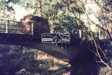
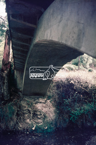
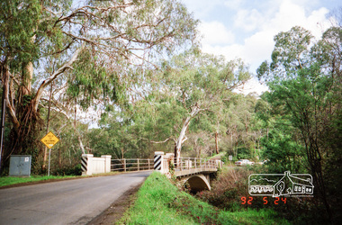
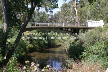
Photograph - Digital Photograph, Alan King, Monash Bridge, Hurstbridge, 23 January 2008
... Bridge spans the Diamond Creek at Hurstbridge. It was built in 1917 for the Shires of Heidelberg, Eltham and Whittlesea. It is considered Nillumbik Shire's finest engineered bridge and was construced by the engineering company of Sir John Monash. Covered under Heritage Overlay, Nillumbik Planning Scheme. Published: Nillumbik Now and Then / Marguerite Marshall 2008; photographs Alan King with Marguerite Marshall.; p117 Monash Bridge is considered the Shire’s finest engineered bridge and was constructed by the engineering company of that great Australian, Sir John Monash.1 The bridge spans Diamond Creek on the Hurstbridge-Arthurs Creek Road, linking Hurstbridge with Yarrambat and Arthurs Creek. ...Bridge spans the Diamond Creek at Hurstbridge. It was built in 1917 for the Shires of Heidelberg, Eltham and Whittlesea. It is considered Nillumbik Shire's finest engineered bridge and was construced by the engineering company of Sir John Monash. Covered under Heritage Overlay, Nillumbik Planning Scheme. Published: Nillumbik Now and Then / Marguerite Marshall 2008; photographs Alan King with Marguerite Marshall.; p117 Monash Bridge is considered the Shire’s finest engineered bridge and was constructed by the engineering company of that great Australian, Sir John Monash.1 The bridge spans Diamond Creek on the Hurstbridge-Arthurs Creek Road, linking Hurstbridge with Yarrambat and Arthurs Creek. ...Monash Bridge spans the Diamond Creek at Hurstbridge. It was built in 1917 for the Shires of Heidelberg, Eltham and Whittlesea. It is considered Nillumbik Shire's finest engineered bridge and was construced by the engineering company of Sir John Monash. Covered under Heritage Overlay, Nillumbik Planning Scheme. Published: Nillumbik Now and Then / Marguerite Marshall 2008; photographs Alan King with Marguerite Marshall.; p117 Monash Bridge is considered the Shire’s finest engineered bridge and was constructed by the engineering company of that great Australian, Sir John Monash.1 The bridge spans Diamond Creek on the Hurstbridge-Arthurs Creek Road, linking Hurstbridge with Yarrambat and Arthurs Creek. Monash Bridge, also called Hurst’s Bridge, was built in 1917, by the Reinforced Concrete and Monier Pipe Construction Company Pty Ltd, for the Shires of Heidelberg, Eltham and Whittlesea. Although Monash was probably in action overseas during World War One when the bridge was designed and constructed, he evolved the basic design in the 1900s and it was a standard design for the firm. However J A Laing, a designer at the firm, was probably the designer, as his initials are on bridge drawings held by the Eltham District Historical Society.2 The bridge is an excellent early Australian example of an open spandrel reinforced concrete arch bridge and has a single span of 29 metres. It is unusual in Victoria, but similar to many reinforced concrete arch bridges in Europe and America, built from the late 19th century. In Victoria, Monash pioneered the use of reinforced concrete – then a revolutionary construction material. His company, Monash & Anderson, had the exclusive licence for the Monier patent for the system of reinforced concrete construction for Victoria and New South Wales. A well-known example of the Monier arch bridge is the Morell Bridge in South Yarra. The sweeping arch of the Monash Bridge combines grace and utility and blends with the surrounding rural landscape. Its design and construction have allowed it to carry increasing volumes of heavy traffic, but in modern times the one lane is considered by some to prevent easy passage through Hurstbridge. However others consider this an asset to deter too much more traffic, which would diminish Hurstbridge’s charming rural character.3 This is the third bridge across the Diamond Creek at this site. The original bridge was a log bridge upstream, constructed in the 1850s by early settler, Henry Hurst, after whom Hurstbridge was named. The bridge spanned the creek, where it divided his family’s property. In the 1880s a timber bridge replaced it, known as Hurst’s Bridge. However a more permanent bridge was considered necessary when the new railway arrived in 1912, bringing with it expectations of growth in the town and the surrounding fruit-growing district. Monash Bridge’s official opening on November 3, 1917 was a gala occasion, which took place before about 1000 spectators. Two who attended the opening had a particularly sound knowledge of the locality. One was Fred Hurst, Henry’s brother, who used to ford the creek at or near the bridge’s site more than 50 years before. The other was John McDonald of Arthurs Creek, who had built the old wooden bridge over the creek about 40 years earlier.4 Although John Monash was a fine engineer, his fame came from his brilliant war career, rather than from his engineering or his many other achievements. Monash was Corps Commander of the Australian Forces. His brilliance was recognised with his awards: Knight Grand Cross of the Order of St. Michael and St. George, and Knight Commander of the Bath. Monash was also decorated by the French, Belgian, and American Governments.5 After the war, Monash worked in many prominent civilian positions, the most notable as head of the Victorian State Electricity Commission. He was a leading and loved public figure, involved in many public and private organisations. He was president of the Australian Zionist Federation and involved in the Boy Scouts. Monash University is named after him. By the 1920s Monash was probably regarded as the greatest living Australian.6 Despite most of his life working as an administrator and leader, rather than a fighting soldier, he became integral to the ANZAC legend. Monash died in 1931.This collection of almost 130 photos about places and people within the Shire of Nillumbik, an urban and rural municipality in Melbourne's north, contributes to an understanding of the history of the Shire. Published in 2008 immediately prior to the Black Saturday bushfires of February 7, 2009, it documents sites that were impacted, and in some cases destroyed by the fires. It includes photographs taken especially for the publication, creating a unique time capsule representing the Shire in the early 21st century. It remains the most recent comprehenesive publication devoted to the Shire's history connecting local residents to the past. nillumbik now and then (marshall-king) collection, hurstbridge, monash bridge -
 Greensborough Historical Society
Newspaper Clipping, Jane Freeman, Clifton Pugh and Prue Acton, by Jane Freeman, 20/08/1989
... Clifton Pugh lived at 'Dunmoochin' on the Cottles Bridge-Strathewen Road between Hurstbridge and Arthur's Creek....Greensborough Historical Society 34A Glenauburn Road Lower Plenty Lower Plenty melbourne Relationship between Clifton Pugh and Prue Acton based on their common interest in painting. Clifton Pugh lived at 'Dunmoochin' on the Cottles Bridge-Strathewen Road between Hurstbridge and Arthur's Creek. clifton pugh prue acton painters hurstbridge Text and col. photograph Clifton Pugh and Prue Acton, by Jane Freeman Newspaper Clipping Jane Freeman Sun Herald ...Relationship between Clifton Pugh and Prue Acton based on their common interest in painting. Clifton Pugh lived at 'Dunmoochin' on the Cottles Bridge-Strathewen Road between Hurstbridge and Arthur's Creek.Text and col. photographclifton pugh, prue acton, painters, hurstbridge -
Halls Gap & Grampians Historical Society
Photograph - Photocopy, C 1925
... Halls Gap & Grampians Historical Society Centennial Hall 117-119 Grampians Road Halls Gap grampians The woman's name is Mavis Klauss and the boy is Arthur Klauss. The bridge is over the McKenzie Creek at Zumsteins. ...The woman's name is Mavis Klauss and the boy is Arthur Klauss. The bridge is over the McKenzie Creek at Zumsteins. The Klauss family often camped in this area.The photo shows a woman and boy sitting on a bridge dangling their feet over a wide creek. A horse is teathered in the background on the left of the photo, where a building can also be seen.people, klauss, structures, bridges -
 Eltham District Historical Society Inc
Journal - Newsletter, Shire of Eltham, Shire of Eltham newsletter, 1979
... Subjects include President's message, Eltham-templestowe intersection, indoor recreational centre, Bridge over Watsons Creek, town square, list of councillors, forward planning, recreational faciliaites including Eltham town park, Hurstbridge hall, roads, community welfare services, eltham Community and reception centre opening, amenities for youth, concrete bridge at Arthurs creek and Mitton's Bridge at St Andrew's ...Subjects include President's message, Eltham-templestowe intersection, indoor recreational centre, Bridge over Watsons Creek, town square, list of councillors, forward planning, recreational faciliaites including Eltham town park, Hurstbridge hall, roads, community welfare services, eltham Community and reception centre opening, amenities for youth, concrete bridge at Arthurs creek and Mitton's Bridge at St Andrew's harry gilham collection intersection round-about recreation recreational centre watsons creek town square councilors newsletter planning parks hurstbridge hall community welfare service roads eltham community and reception centre youth skateboard track mitton's bridge arthur's creek fitzsimons lane main road road construction rondabout Newsprint, 4 pages Shire of Eltham newsletter Journal Newsletter Shire of Eltham ...Articles, some with photos. Subjects include President's message, Eltham-templestowe intersection, indoor recreational centre, Bridge over Watsons Creek, town square, list of councillors, forward planning, recreational faciliaites including Eltham town park, Hurstbridge hall, roads, community welfare services, eltham Community and reception centre opening, amenities for youth, concrete bridge at Arthurs creek and Mitton's Bridge at St Andrew's Newsprint, 4 pages harry gilham collection, intersection, round-about, recreation, recreational centre, watsons creek, town square, councilors, newsletter, planning, parks, hurstbridge hall, community welfare service, roads, eltham community and reception centre, youth, skateboard track, mitton's bridge, arthur's creek, fitzsimons lane, main road, road construction, rondabout -
 Eltham District Historical Society Inc
Work on paper (Sub-Item) - Photograph, Monash Bridge, Arthurs Creek Road, Hurstbridge, 1917
... Eltham District Historical Society Inc 728 Main Rd Eltham melbourne Black and white photograph of the new bridge opened in 1917. bridge hurstbridge Image printed on A4 page from 04997 Diamond Creek Basin Study, 1980 Monash Bridge, Arthurs Creek Road, Hurstbridge, 1917 Work on paper Photograph ...Black and white photograph of the new bridge opened in 1917.bridge, hurstbridge -
 Eltham District Historical Society Inc
Negative - Photograph, J.A. McDonald, Laidlays Road, Arthurs Creek, April 1962
... Eltham District Historical Society Inc 728 Main Rd Eltham melbourne Bridge over Arthurs Creek Looking east April 1962 Record of various Shire of Eltham infrastructure works undertaken during the period of 1952-1962 involving bridge and road reconstruction projects, sometimes with Eltham Shire Council Project Reference numbers quoted. ...Bridge over Arthurs Creek Looking east April 1962Record of various Shire of Eltham infrastructure works undertaken during the period of 1952-1962 involving bridge and road reconstruction projects, sometimes with Eltham Shire Council Project Reference numbers quoted. It was during this period that a number of significant improvements were made to roads and new bridges constructed within the shire that remain in place as of present day (2022). In many situations, the photos provide a tangible visible record of infrastructure that existed throughout the early days of the Shire. The album was put together by or under the direction of the Shire Engineer, J.A. McDonald.1962-04, arthurs creek, bridge construction, infrastructure, laidlays road, shire of eltham -
 Eltham District Historical Society Inc
Album - Photograph Album, J.A. McDonald, Bridge and Road Reconstruction Works, Shire of Eltham, 1952-1962
... Road City of Preston Cr. A. Brinkkotter Cr. Charis Pelling Cranes Cromwell Street Diamond Creek (Creek) Diamond Street Dixons Creek Bridge Dixon's Creek Road Drott Eltham Leisure Centre Eltham North Eltham Police Station Eltham Eltham-Yarra Glen Road F. Wood Fitzsimons Lane Bridge Flat Rock Road Flood damage floods Floodwater Footpaths and gutters Ford Service Garage G. Blair Garden Hill Glen Park Bridge Glenauburn Road Grand Hotel Haldane Road Healesville Healesville-Yarra Glen Road Heidelberg-Kinglake Road Henley Road Bridge Henley Road Hill property Hurstbridge Water scheme Hurstbridge Hurstbridge-Arthurs ...J.A. McDonald produced this record in the course of his responsibilities as Shire Engineer for Eltham Shire Council.Record of various Shire of Eltham infrastructure works undertaken during the period of 1952-1962 involving bridge and road reconstruction projects, sometimes with Eltham Shire Council Project Reference numbers quoted. It was during this period that a number of significant improvements were made to roads and new bridges constructed within the shire that remain in place as of present day (2022). In many situations, the photos provide a tangible visible record of infrastructure that existed throughout the early days of the Shire. The album was put together by or under the direction of the Shire Engineer, J.A. McDonald.a. gillies, alistair knox park, benchmark studies, bend of islands, blease road, box hill state school, box hill teachers college, box hill tip, bridge construction, bridge street bridge, bridge, brisbane street, brougham steet, bulldozer, cecil street, charis pelling, cherry tree road, city of preston, cr. a. brinkkotter, cr. charis pelling, cranes, cromwell street, diamond creek (creek), diamond street, dixons creek bridge, dixon's creek road, drott, eltham leisure centre, eltham north, eltham police station, eltham, eltham-yarra glen road, f. wood, fitzsimons lane bridge, flat rock road, flood damage, floods, floodwater, footpaths and gutters, ford service garage, g. blair, garden hill, glen park bridge, glenauburn road, grand hotel, haldane road, healesville, healesville-yarra glen road, heidelberg-kinglake road, henley road bridge, henley road, hill property, hurstbridge water scheme, hurstbridge, hurstbridge-arthurs creek road, infrastructure, j. jolly, kangaroo ground, kangaroo ground-queenstown road, kangaroo ground-st andrews road, lilydale shire office, long gully bridge, long gully creek, long gully road, long gully, lower plenty bridge, lower plenty footbridge, lower plenty oval, lower plenty road, lower plenty, main road, methodist church, montmorency, mount pleasant road, new holland, old healesville road, opening ceremony, oxley bridge, para road, paul creek bridge, paul creek road, paul krafeznk, pinnacle lane, plaques, plenty river trail, plenty river, presbyterian church, prof donald thomson, pryor street, railway crossing, railway parade, rattray road, reconstruction works, reichelt avenue, research (vic.), research oval, road construction, rymers corner, shire of eltham, shire of whittlesea, silvan road bridge, silver street bridge, silver street, sir dallas brooks, smedley property, st andrews, steels creek, susan street, tarrawarra, tony carberry, uniting church, upper yarra dam, upper yarra reservoir, w.e. wolf, waterfall property, watsons creek, wattletree road bridge, wattletree road, wattletree road bridge, worlingworth, yarra glen, york street, yow yow creek -
 Eltham District Historical Society Inc
Negative - Photograph, J.A. McDonald, Laidlays Road, Arthurs Creek, April 1962
... Eltham District Historical Society Inc 728 Main Rd Eltham melbourne Bridge over Arthurs Creek Looking east April 1962 Record of various Shire of Eltham infrastructure works undertaken during the period of 1952-1962 involving bridge and road reconstruction projects, sometimes with Eltham Shire Council Project Reference numbers quoted. ...Bridge over Arthurs Creek Looking east April 1962Record of various Shire of Eltham infrastructure works undertaken during the period of 1952-1962 involving bridge and road reconstruction projects, sometimes with Eltham Shire Council Project Reference numbers quoted. It was during this period that a number of significant improvements were made to roads and new bridges constructed within the shire that remain in place as of present day (2022). In many situations, the photos provide a tangible visible record of infrastructure that existed throughout the early days of the Shire. The album was put together by or under the direction of the Shire Engineer, J.A. McDonald.1962-04, arthurs creek, bridge construction, infrastructure, laidlays road, shire of eltham -
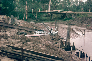
 Eltham District Historical Society Inc
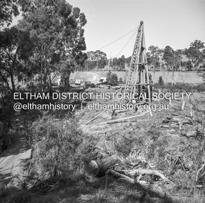
Slide, Construction of new bridge, looking upstream from east bank towards existing Lintons Bridge across Arthurs Creek, Doctors Gully Road, Nutfield, 22 February 1972, 1972
... Eltham District Historical Society Inc 728 Main Rd Eltham melbourne Arthurs Creek, bridge construction, doctors gully road, Eltham Shire Council, Infrastructure, lintons bridge, Nutfield 35 mm colour positive transparency Mount - Agfacolor Service (Blue) Construction of new bridge, looking upstream from east bank towards existing Lintons Bridge across Arthurs Creek, Doctors Gully Road, Nutfield, 22 February 1972 Slide ...35 mm colour positive transparency Mount - Agfacolor Service (Blue)arthurs creek, bridge construction, doctors gully road, eltham shire council, infrastructure, lintons bridge, nutfield -
 Eltham District Historical Society Inc
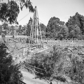
Slide, Construction of new bridge, looking downstream from east bank towards existing Lintons Bridge across Arthurs Creek, Doctors Gully Road, Nutfield, 22 February 1972, 1972
... Eltham District Historical Society Inc 728 Main Rd Eltham melbourne arthurs creek, bridge construction, doctors gully road, eltham shire council, infrastructure, lintons bridge, nutfield 35 mm colour positive transparency Mount - Agfacolor Service (Blue) Construction of new bridge, looking downstream from east bank towards existing Lintons Bridge across Arthurs Creek, Doctors Gully Road, Nutfield, 22 February 1972 Slide ...35 mm colour positive transparency Mount - Agfacolor Service (Blue)arthurs creek, bridge construction, doctors gully road, eltham shire council, infrastructure, lintons bridge, nutfield