Showing 54 items matching "aspendale"
-
 City of Kingston
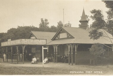
Postcard - Postcard, Colour, Aspendale Post Office, c. 1920
... Aspendale Post Office...Aspendale...Sepia toned postcard featuring the Aspendale Post Office with the Austral Dining Rooms, for afternoon teas and summer drinks, located beside it. ...They were also a popular form of advertising. Aspendale Beach Leisure Post Office Sepia toned postcard featuring the Aspendale Post Office with the Austral Dining Rooms, for afternoon teas and summer drinks, located beside it. ...Postcards began to be produced in Victoria from 1876. Between 1900 and 1920, picture postcards in Australia became an incredibly popular phenomenon. People could cheaply and easily send messages, without the formality of a letter, and they provided a cheap form of souvenir. Eventually, every event of significance was commemorated in some way with a postcard, and this led to the development of a ‘picture on one side and a message/stamp on the other’ postcard we are familiar with today. They were also a popular form of advertising. Sepia toned postcard featuring the Aspendale Post Office with the Austral Dining Rooms, for afternoon teas and summer drinks, located beside it. There are several people sitting on bench seats and in deck chairs infront of the building. A wooden sign post in front of the building points toward the beach.aspendale, beach, leisure, post office -
 Mordialloc College Alumni Association Inc (MCAA)
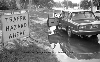
Photograph, 1984 Flooding of Pine Crescent, Aspendale, 1984
... 1984 Flooding of Pine Crescent, Aspendale...Aspendale...Mordialloc College Alumni Association Inc (MCAA) 1 Station Street Aspendale melbourne 1984 Flooding of Pine Crescent, Aspendale Photograph ... -
 Chelsea & District Historical Society Inc
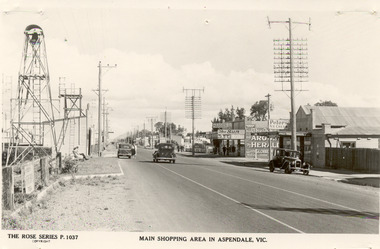
Photograph - Shopping Area, Aspendale, c 1930's
... ...Aspendale...Black and white postcard showing shops on the right hand side of Point Nepean Road and the railway line, Aspendale railway station and the Aspendale Fire Station with the bell tower beside it. ...The Rose Series P. 1037 MAIN SHOPPING AREA IN ASPENDALE, VIC....Chelsea & District Historical Society Inc The Chelsea Activity Hub 3-5 Showers Ave Chelsea 3196 melbourne Point Nepean Road Nepean Highway Aspendale Taylor Avenue shops Aspendale fire station Aspendale Picnic Grounds The Rose Series P. 1037 MAIN SHOPPING AREA IN ASPENDALE, VIC. ...Black and white postcard showing shops on the right hand side of Point Nepean Road and the railway line, Aspendale railway station and the Aspendale Fire Station with the bell tower beside it. One car driving along the road and two cars parked. The shops in view are a cafe, a general store, the Aspendale Picnic Grounds, which included Palais De Dance.The Rose Series P. 1037 MAIN SHOPPING AREA IN ASPENDALE, VIC.point nepean road, nepean highway, aspendale, taylor avenue, shops, aspendale fire station, aspendale picnic grounds -
 Bacchus Marsh & District Historical Society
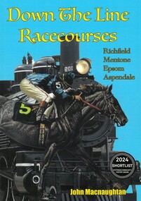
Book, Down the Line Racecourses: Richfield, Mentone, Epsom, Aspendale
... Down the Line Racecourses: Richfield, Mentone, Epsom, Aspendale...Citation: Down the Line Racecourses: Richfield, Mentone, Epsom, Aspendale. By John Macnaughton. Published by John Macnaughton, 2023. ...BMDHS Location: AR/SU5 Down the Line Racecourses: Richfield, Mentone, Epsom, Aspendale Book ...A history of some of the lesser known horse racecourses in the greater Melbourne area. The relevance of this book for Bacchus Marsh history is in Chapter 5, 'Aspendale', pages 110-115, and the section titled 'The Founder: The Crook Family'. This section describes the Crook family involvement in the founding of Aspendale racecourse and in particular the involvement of James Elijah Crook in horseracing.Printed paperback book. A4 size. 144 pages. Black and white photos. Subject and people indexes. Endnotes for each chapter. Citation: Down the Line Racecourses: Richfield, Mentone, Epsom, Aspendale. By John Macnaughton. Published by John Macnaughton, 2023. BMDHS Location: AR/SU5non-fictionA history of some of the lesser known horse racecourses in the greater Melbourne area. The relevance of this book for Bacchus Marsh history is in Chapter 5, 'Aspendale', pages 110-115, and the section titled 'The Founder: The Crook Family'. This section describes the Crook family involvement in the founding of Aspendale racecourse and in particular the involvement of James Elijah Crook in horseracing.crook family bacchus marsh, james elijah crook 1819-1889, horse racing, racecourses -
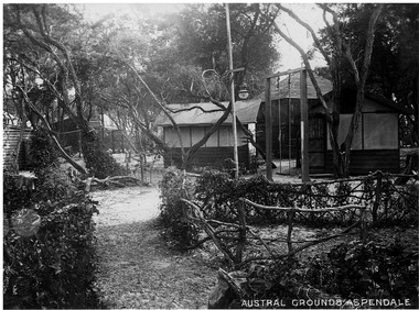 Chelsea & District Historical Society Inc
Photograph - Austral Grounds, Aspendale
... ...Aspendale...Black and white photo of the Austral Grounds, Aspendale....Chelsea & District Historical Society Inc The Chelsea Activity Hub 3-5 Showers Ave Chelsea 3196 melbourne Austral Grounds Aspendale Black and white photo of the Austral Grounds, Aspendale. ...Black and white photo of the Austral Grounds, Aspendale.austral grounds, aspendale -
 City of Kingston
Photograph - Colour, 6 March 1993
... ...Aspendale...It is located between Aspendale and Chelsea on the Port Phillip Bay and built within remnant areas of the Carrum Carrum swamp. ...The image shows vacant land in the area now known as Aspendale Gardens and the newer residential section of Chelsea Heights is not developed. ...It is located between Aspendale and Chelsea on the Port Phillip Bay and built within remnant areas of the Carrum Carrum swamp. ...Edithvale is a suburb in the City of Kingston. It is located between Aspendale and Chelsea on the Port Phillip Bay and built within remnant areas of the Carrum Carrum swamp. The foreshore precinct comprises a wide sandy beach, with low sand dunes and numerous historic boat sheds. The suburb consists of older style dwellings and former holiday houses, combined with mid-century housing and newer homes. The large blocks are increasingly subdivided and the existing dwellings demolished to accommodate units and townhouses, thus changing the landscape of the area and reducing the tree canopy.The beachside suburb of Edithvale was previously part of the extensive Carrum Carrum Swamp. The area was once a source of fish and eels for the Mayone-Bulluk clan of the Bunurong people. Over time the area was drained and predominantly devoted to dairy farming and holiday houses. The farms were gradually sold and subdivided with a large number of homes built after World War II and in the 1960s. Edithvale is mainly residential with a shopping strip along Nepean Highway but little significant industry was ever established in the area apart from a plaster works and confectionary factory, both now closed.Laminated aerial colour photograph of Edithvale as viewed from Alexandra Avenue in the north to Ella Grove Chelsea/Edithvale in the south. regents Park Aspendale can be seen in the top left. The area is built-up with residential housing and facilities including Edithvale Primary School, numerous churches and the Edithvale Railway station. Large sections depict the remnant Carrum Carrum swamp. Edithvale Common and the former "Duck Inn" (Melbourne Water/Friends of Edithvale Seaford Wetlands) can be seen. Edithvale Recreational reserve, the valodrome and Edithvale Public Golf Course are prominent. The image shows vacant land in the area now known as Aspendale Gardens and the newer residential section of Chelsea Heights is not developed. A bike path has been established to cover the secondary drain. The Golf Links Court residential development located off Hughes Avenue is a large vacant block.Black type on white adhesive label: 6-3-93 Black type on white adhesive label: 25/9211, 6/3/93, 11.20 am Black type on white adhesive label: 9211 Yellow circular adhesive sticker Black pencil: 9211 6-3-93 arrow pointing Nedthvale, carrum carrum swamp, aspendale, chelsea -
City of Kingston
Photograph - Colour, Circa 1993
... ...Aspendale...It is located between Aspendale and Chelsea on the Port Phillip Bay and built within remnant areas of the Carrum Carrum swamp. ...The image shows vacant land in the area now known as Aspendale Gardens and the newer residential section of Chelsea Heights is not developed. ...It is located between Aspendale and Chelsea on the Port Phillip Bay and built within remnant areas of the Carrum Carrum swamp. ...Edithvale is a suburb in the City of Kingston. It is located between Aspendale and Chelsea on the Port Phillip Bay and built within remnant areas of the Carrum Carrum swamp. The foreshore precinct comprises a wide sandy beach, with low sand dunes and numerous historic boat sheds. The suburb consists of older style dwellings and former holiday houses, combined with mid-century housing and newer homes. The large blocks are increasingly subdivided and the existing dwellings demolished to accommodate units and townhouses, thus changing the landscape of the area and reducing the tree canopy.The beachside suburb of Edithvale was previously part of the extensive Carrum Carrum Swamp. The area was once a source of fish and eels for the Mayone-Bulluk clan of the Bunurong people. Over time the area was drained and predominantly devoted to dairy farming and holiday houses. The farms were gradually sold and subdivided with a large number of homes built after World War II and in the 1960s. Edithvale is mainly residential with a shopping strip along Nepean Highway but little significant industry was ever established in the area apart from a plaster works and confectionary factory, both now closed.Aerial colour photograph of Edithvale as viewed from Alexandra Avenue in the north to Ella Grove Chelsea/Edithvale in the south. The area is built-up with residential housing and facilities including Edithvale Primary School, numerous churches and the Edithvale Railway station. Large sections depict the remnant Carrum Carrum swamp. Edithvale Common and the former "Duck Inn" (Melbourne Water/Friends of Edithvale Seaford Wetlands) can be seen. Edithvale Recreational reserve, the velodrome and Edithvale Public Golf Course are prominent. The image shows vacant land in the area now known as Aspendale Gardens and the newer residential section of Chelsea Heights is not developed. A bike path has been established to cover the secondary drain. The Golf Links Court residential development located off Hughes Avenue is a large vacant block.Yellow circular adhesive sticker on plastic Black ink (marker): * (asterisk) Black type on white adhesive sticker: P000108edithvale, aspendale, chelsea, carrum carrum swamp -
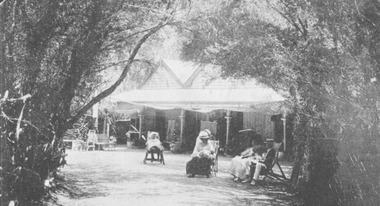 Chelsea & District Historical Society Inc
Photograph - Chalet at Aspendale, 1910
... ...Aspendale...The Aspendale Chalet was about 18 miles from Melbourne between the railway station and the beach. ...Photograph Chalet at Aspendale ...The Aspendale Chalet was about 18 miles from Melbourne between the railway station and the beach. It was a seaside "resort" where people could camp amongst the ti-trees. In 1911, the Chalet was subdivided and the blocks were sold.Four guest sitting on deck chairs in the Chalet gardens.chalet, aspendale, holidays -
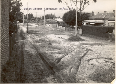 Chelsea & District Historical Society Inc
Photograph - First Avenue, Aspendale, 1949
... ...Aspendale...Black and white photo looking east along First Avenue, Aspendale. The road us unmade and rusted with vegetation growing on the road, houses and electricity poles line both sides. ...Photograph First Avenue, Aspendale ...This photo is one of a collection of photos taken during Alan Niemann's - Drainage-Road Making Scheme. First Avenue runs between Station Street and Sixth Avenue.Black and white photo looking east along First Avenue, Aspendale. The road us unmade and rusted with vegetation growing on the road, houses and electricity poles line both sides. unmade street, aspendale, first avenue, alan niemann, drainage-road making scheme -
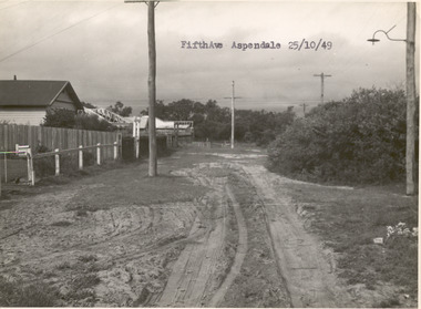 Chelsea & District Historical Society Inc
Photograph - Fifth Avenue, Aspendale, 1949
... ...Aspendale...Black and white photo of Fifth Avenue, Aspendale. The road is unmade with grass growing on the road, is rutted, houses can be seen on the left and electricity poles are both side of the road. ...Photograph Fifth Avenue, Aspendale ...This photo is one of a collection of photos taken during Alan Niemann's - Drainage-Road Making Scheme.Black and white photo of Fifth Avenue, Aspendale. The road is unmade with grass growing on the road, is rutted, houses can be seen on the left and electricity poles are both side of the road. unmade street, aspendale, alan niemann, drainage-road making scheme, edithvale, fifth avenue -
 Chelsea & District Historical Society Inc
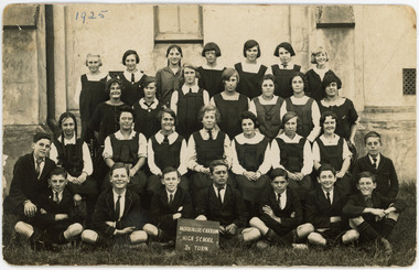
Photograph - Mordialloc Carrum High School, Form D2, 1925
... Station Street, Aspendale, Victoria, Australia ...Mordialloc Carrum High SchoolPhoto depicts students at high school in 1925 Form D2Black and White Postcard depicting secondary school students in 1925 Mordialloc Carrum SchoolMordialloc - Carrum / Mordialloc Chelsea High School. Group of secondary school children in 1925. Form D2 Recipe of fruit cake on back. Fruit Cake- Rich Fruit Cake. 1/2 lb butter, 5 eggs, pinch salt, 1/2 lb sugar, ? sultanas, 2 almonds, 2 oz SR Flour, 1/2 nutmeg grated, 1 dst ground cinnamon, 1 dst. ground alspice, 1 tsp vanilla. Cream butter & sugar, add eggs, fruit, spice, almonds, sifted flour. Mix well, put in tin lined with paper. Place on scone tray, cook from 3-4 hours, very low oven.Cover with paper. Brush with egg white.education, school, morialloc, carrum -
 Chelsea & District Historical Society Inc
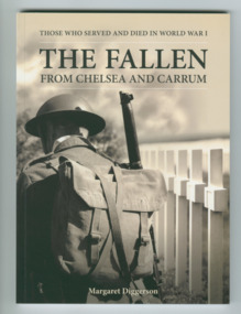
Book - The Fallen: From Chelsea and Carrum - printed 2014, Margaret Diggerson, The Fallen: From Chelsea and Carrum
... Chelsea, Aspendale, Edithvale, Bonbeach and Carrum, Victoria ...Accounts of the lives of WW1 soldiers from Chelsea and districtSmall soft cover booknon-fictionAccounts of the lives of WW1 soldiers from Chelsea and districtlocal men of chelsea who served in ww1 -
 Bendigo Military Museum
Photograph - PHOTOGRAPH, FRAMED
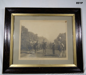
... Bushmans Contingent at Aspendale Park on route Langwarrin to South Africa. ...Bendigo Military Museum 37 - 39 Pall Mall Bendigo goldfields photography-photographs frame accessories Bushmans Contingent at Aspendale Park on route Langwarrin to South Africa. ...Brown wooden outer frame with gold inner boarder. Glass front, sepia photo mounted on grey background. Brown paper backing on frame. Depicts civilian giving directions to Bushmen mounted on horses, trees are in the background.Bushmans Contingent at Aspendale Park on route Langwarrin to South Africa. 'Stockings' troop horse No 5.photography-photographs, frame accessories -
 Chelsea & District Historical Society Inc
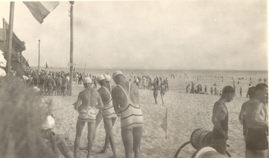
Photograph - Aspendale Life Saving Carnival 1940_50s, Clubs - Life Savings, 1940's - 1950
... Life Saving Carnival - Aspendale Beach, showing large pole in centre of photo. ...Clubs - Life Savings Photograph Aspendale Life Saving Carnival 1940_50s ...Life Saving Carnival - Aspendale Beach, showing large pole in centre of photo. Sign - Grove's St to Aspendale Station. Flag pole, reel & line, life savers & spectators, people swimming. -
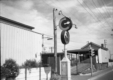 Melbourne Tram Museum
Negative - Marshalite traffic light Nepean Highway, Hugh Ballment, c1954
... The photograph shows a Marshalite traffic signal at a railway station along the Frankston line - such signals were provided at Chelsea, Bonbeach and Aspendale....Melbourne Tram Museum 8 Wallen Road Hawthorn melbourne The photograph shows a Marshalite traffic signal at a railway station along the Frankston line - such signals were provided at Chelsea, Bonbeach and Aspendale. Yields information about the Marshalite traffic lights installed at ? ...The photograph shows a Marshalite traffic signal at a railway station along the Frankston line - such signals were provided at Chelsea, Bonbeach and Aspendale.Yields information about the Marshalite traffic lights installed at ? station.Negative - 127 film black and whitetraffic lights, marshalite, railways, nepean highway -
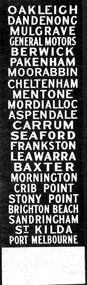 Ballarat Tramway Museum
Sign - Sign - Destination Blinds, Trains, Victorian Rail Suburban Train Destination Blind in Miniature: South Eastern Region
... ...aspendale...From Moorabbin, Cheltenham, Mentone, Mordiallic, Aspendale, Carrum and Seaford. Frankston to Leawarra, Baxter, Mornington, Crib Point, Stony Point, Brighton Beach, Sandringham, St Kilda and Port Melbourne...From Moorabbin, Cheltenham, Mentone, Mordiallic, Aspendale, Carrum and Seaford. Frankston to Leawarra, Baxter, Mornington, Crib Point, Stony Point, Brighton Beach, Sandringham, St Kilda and Port Melbourne train destination blinds miniature railway stations ron bridger collection suburban train oakleigh dandenong berwick pakenham moorabbin cheltenham mentone mordiallic aspendale seaford baxter mornington crib point brighton beach port melbourne Place names - stations List of names on black paper with white print. ...Ron Bridger was an avid collector of items related to transport, predominately Trams. These items include newspaper cuttings, pamphlets, reports, timetables, fares prices plus special items relating to events. Items from Melbourne and regional Victoria, interstate - Adelaide and Sydney, plus overseas, make up this collection. A suburban train destination blind in miniature. Place names indicate the eastern and southern suburbs that the train travels to. Place names listed are from Oakleigh to Dandenong, Mulgrave, General Motors, Berwick and Pakenham. From Moorabbin, Cheltenham, Mentone, Mordiallic, Aspendale, Carrum and Seaford. Frankston to Leawarra, Baxter, Mornington, Crib Point, Stony Point, Brighton Beach, Sandringham, St Kilda and Port MelbourneList of names on black paper with white print.Place names - stationstrain destination blinds, miniature, railway stations, ron bridger collection, suburban train, oakleigh, dandenong, berwick, pakenham, moorabbin, cheltenham, mentone, mordiallic, aspendale, seaford, baxter, mornington, crib point, brighton beach, port melbourne -
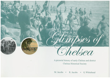 Chelsea & District Historical Society Inc
Book, G.Whitehead, Glimpses of Chelsea, 2007
... Aspendale...Various Sporting clubs and groups, businesses, buildings, streets and early European settlers and others. Aspendale Carrum Bonbeach Edithvale Chelsea A pictorial history of early Chelsea & District first printed 2007 Large soft cover book Glimpses of Chelsea Book Book G.Whitehead M Jacobs R Jacobs ...Photos and descriptions of historical buildings Chelsea District Historical Society is fortunate to have many photos that have been donated and collated over the last fifty years. In the early years our beachside suburb was popular with groups and families. Camping & holidaying in guest houses or privately rented houses. This book includes photographs of local people, beaches, churches, clubs, sports, hotels, railways, industry, hospitals and halls, and many other pictures of local scenes. A unique history of the District of Chelsea. Photographs show the beginnings and how the Chelsea district was developed. Various Sporting clubs and groups, businesses, buildings, streets and early European settlers and others. Large soft cover book A pictorial history of early Chelsea & District first printed 2007aspendale, carrum, bonbeach, edithvale, chelsea -
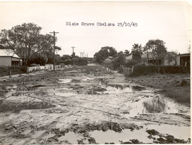 Chelsea & District Historical Society Inc
Photograph - Elsie Grove, Chelsea, 1949
... ...Aspendale...Elsie Grove runs between Station Street and Randal Avenue, Chelsea. unmade street Aspendale Alan Niemann Drainage-Road Making Scheme Elsie Grove Black and white photo looking east along Elsie Grove, Chelsea. ...This photo is one of a collection of photos taken during Alan Niemann's - Drainage-Road Making Scheme. Elsie Grove runs between Station Street and Randal Avenue, Chelsea.Black and white photo looking east along Elsie Grove, Chelsea. The road is unmade and rutted with large puddles, houses line both sides and electricity poles are on the left side of the road. The photo has been taken from Station Street.unmade street, aspendale, alan niemann, drainage-road making scheme, elsie grove -
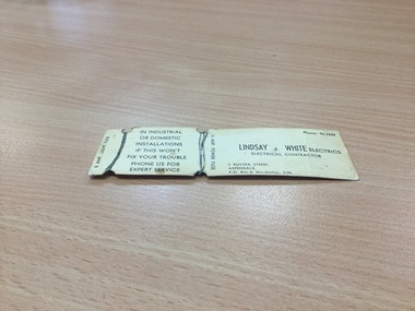 Chelsea & District Historical Society Inc
Tool - Fuse Wire, lindsay electrics, Lindsay White Electrics, Electrical Contractor, 7 Ruvina Street , PO Box 8, Mordialloc, 3195 PH: 90 2409, C 1940's
... donated by lindsay electrics from aspendale item shows how electricians had to repair power boards within the home one had to take out the old fuse which was installed on power board, fuse was made of ceramic, and then rewire ...Chelsea & District Historical Society Inc The Chelsea Activity Hub 3-5 Showers Ave Chelsea 3196 melbourne donated by lindsay electrics from aspendale item shows how electricians had to repair power boards within the home one had to take out the old fuse which was installed on power board, fuse was made of ceramic, and then rewire object significant is that this is now a unique sample of how our home were wired for home and industry electrical/electrics contractor domestic/industrial lindsay white electrics electrical contractor in industrial or domestic installations if this wont fix your trouble phone us for expert sevice 8 amp light fuse 15 mp power fuse fuse wire on paper mount Lindsay White Electrics, Electrical Contractor, 7 Ruvina Street , PO Box 8, Mordialloc, 3195 PH: 90 2409 Tool Fuse Wire lindsay electrics ...donated by lindsay electrics from aspendale item shows how electricians had to repair power boards within the home one had to take out the old fuse which was installed on power board, fuse was made of ceramic, and then rewire object significant is that this is now a unique sample of how our home were wired for home and industryfuse wire on paper mountlindsay white electrics electrical contractor in industrial or domestic installations if this wont fix your trouble phone us for expert sevice 8 amp light fuse 15 mp power fuseelectrical/electrics, contractor, domestic/industrial -
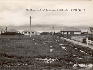 Chelsea & District Historical Society Inc
Photograph - Haig Avenue, Edithvale, 1949
... ...Aspendale...Chelsea & District Historical Society Inc The Chelsea Activity Hub 3-5 Showers Ave Chelsea 3196 melbourne This photo is one of a collection of photos taken during Alan Niemann's - Drainage-Road Making Scheme. unmade street Aspendale Alan Niemann Drainage-Road Making Scheme Haig Avenue Edithvale Two black and white photo of the northern and southern ends of Haig Avenue, Edithvale. ...This photo is one of a collection of photos taken during Alan Niemann's - Drainage-Road Making Scheme.Two black and white photo of the northern and southern ends of Haig Avenue, Edithvale. The road is unmade with grass growing on the road, is rutted with large puddles, houses line both sides and electricity poles are both side of the road. unmade street, aspendale, alan niemann, drainage-road making scheme, haig avenue, edithvale -
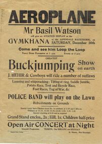 Bendigo Historical Society Inc.
Document - BASIL WATSON COLLECTION: ADVERTISING POSTERS FOR AVIATION DISPLAYS OF B WATSON, 1916- 1917
... ''Aeroplane'' - gymkhana at Aspendale Racecourse, 30th Dec, (1916); b. ''Sensational Aviation'' - general leaflet on Basil Watson with picture of plane; c. ...''Aeroplane'' - gymkhana at Aspendale Racecourse, 30th Dec, (1916); b. ''Sensational Aviation'' - general leaflet on Basil Watson with picture of plane; c. ...Collection of advertising posters for aviation displays of Basil Watson: a. ''Aeroplane'' - gymkhana at Aspendale Racecourse, 30th Dec, (1916); b. ''Sensational Aviation'' - general leaflet on Basil Watson with picture of plane; c. ''Aerial Mail'' Mt Gambier to Melbourne includes photo of biplane and Basil Watson; d. ''Sensational Aviation'' Basil Watson is coming.person, individual, basil watson -
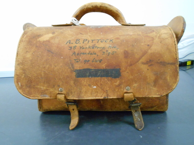 Bendigo Historical Society Inc.
Functional object - PITTOCK COLLECTION: COACH BUILDER'S LEATHER BAG, 20th century
... Coach Builder's Leather Bag belonging to (Albert) Barrie Pittock marked of front and internally: A B Pittock 38 Yackatoon Avenue Aspendale, 3195 Leather tradesman's tool bag, single handle on top of rectangular bag, with two buckles. ...History House 11 Mackenzie Street Bendigo goldfields TOOLS Multipurpose tradesman tool bag Coach Builder's Leather Bag belonging to (Albert) Barrie Pittock marked of front and internally: A B Pittock 38 Yackatoon Avenue Aspendale, 3195 Leather tradesman's tool bag, single handle on top of rectangular bag, with two buckles. ...Coach Builder's Leather Bag belonging to (Albert) Barrie Pittock marked of front and internally: A B Pittock 38 Yackatoon Avenue Aspendale, 3195 Leather tradesman's tool bag, single handle on top of rectangular bag, with two buckles. Bag worn and marked through use. Bag etched T.M. on the back of the bag, apears to have attempted to change imnitials to J.M. Stored in Pittock Coachbuilder's box, reference 1300.1tools, multipurpose, tradesman tool bag -
City of Kingston
Photograph - Colour, 29 January 1993
... The station was opened in 1926 and was the last to be established in the group from Aspendale to Carrum. Urban growth began after World War II. ...The station was opened in 1926 and was the last to be established in the group from Aspendale to Carrum. Urban growth began after World War II. ...Bonbeach is a small beachside suburb located between Chelsea and Carrum. The station was opened in 1926 and was the last to be established in the group from Aspendale to Carrum. Urban growth began after World War II. State primary and high schools were opened in 1958 on land in Breeze Street that was once occupied by The Australian Glass Manufacturers. Immediately east of the school sites is the Patterson River Golf Club. The Bonbeach sports reserve has five ovals and is home to the Bonbeach football and baseball clubs. The suburb borders the Edithvale-Seaford Wetlands which is the remnant site of the Carrum Carrum swamp, once the home of the Bunurong people.Bonbeach was originally a seaside destination for holidaymakers and the housing comprised of holiday homes and gradually more permanent residents. It was not until 1926 that Bonbeach had its own railway station. From 1906 until the late 1940s sand was quarried on the east side of the railway line and used in the manufacture of glass. The Australian Glass Manufacturers sold this land in residential blocks and Bonbeach's permanent population spread from the coastal strip across to the other side of the railway line. Laminated colour aerial photograph of the suburb of Bonbeach and also the southern section of neighbouring Chelsea within the City of Kingston. The extent of this 1993 aerial image includes: Top left - Maury Road at the south end of the Chelsea shopping Centre; Top right - Scotch Parade Chelsea Bottom left - Monica Avenue in Bonbeach; Bottom right - Patterson River Golf Club. Landmarks include St Joseph's Church and Primary School, Chelsea Primary School, Bonbeach Station, Bonbeach Fotball Club sports playing fields and Bonbeach Life Saving Club. The Edithvale Wetlands is featured prominently to the right-hand side of the image. Black typed writing on white adhesive label: No. 6662 Black typed writing on white adhesive label: 26E/6662, 29/1/93, 4.25 pm Black typed writing on white adhesive label: 29-1-93 Black typed writing on white adhesive label: P000109 Circular yellow adhesive sticker bonbeach, chelsea -
 Chelsea & District Historical Society Inc
Photograph - Mr Hugh Brown and descendants, Mr Hugh Brown, early 1900's
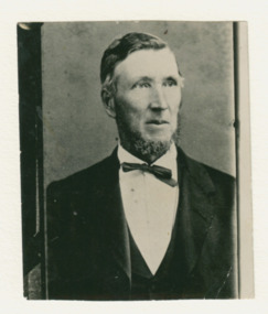
... The Brown family increased their land holding until they held a major part of the farmland between Mordialloc Creek to almost the Aspendale Railway Station. The property was a market garden and orchard. ...The Brown family increased their land holding until they held a major part of the farmland between Mordialloc Creek to almost the Aspendale Railway Station. The property was a market garden and orchard. ...Hugh Brown (1830-1930), born in Ireland, arrived in Adelaide in 1855 and in the Mordialloc district in 1856. Mr Brown brought land in 1866 and built his farmhouse “Pine Vale” in 1870 near the site of the present Mordialloc Secondary College (then part of the property) and extended his property when the swampland was made open for selection in 1871. The property was a market garden and orchard. Hugh Brown married Zillah Baxter in 1857, they had six sons, five living to adulthood. The Brown family increased their land holding until they held a major part of the farmland between Mordialloc Creek to almost the Aspendale Railway Station. The property was a market garden and orchard. Mr Brown took an active interest in the public life of the community, a Justice of the Peace; Councillor of Dandenong Shire for over 30 years, was twice Shire President; and a founding member of the Mordialloc Mechanics Institute. Black and white photo of Mr Hugh Brown.hugh brown, mordialloc, pioneer, market gardener, farmer, pine vale -
 Chelsea & District Historical Society Inc
Photograph - Mr Hugh Brown and descendants, The Brown Children, 1910
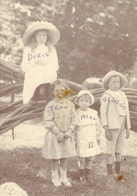
... The Brown family increased their land holding until they held a major part of the farmland between Mordialloc Creek to almost the Aspendale Railway Station. The property was a market garden and orchard. ...The Brown family increased their land holding until they held a major part of the farmland between Mordialloc Creek to almost the Aspendale Railway Station. The property was a market garden and orchard. ...Doris, Alex, George and Jean are the grandchildren of Mr Hugh Brown. Hugh Brown (1830-1930), born in Ireland, arrived in Adelaide in 1855 and in the Mordialloc district in 1856. Mr Brown brought land in 1866 and built his farmhouse “Pine Vale” in 1870 near the site of the present Mordialloc Secondary College (then part of the property) and extended his property when the swampland was made open for selection in 1871. The property was a market garden and orchard. Hugh Brown married Zillah Baxter (1866) and they had six sons, five living to adulthood. The Brown family increased their land holding until they held a major part of the farmland between Mordialloc Creek to almost the Aspendale Railway Station. The property was a market garden and orchard. Mr Brown took an active interest in the public life of the community, a Justice of the Peace; Councillor of Dandenong Shire for over 30 years, was twice Shire President; and a founding member of the Mordialloc Mechanics Institute. Black and white studio photo of the Brown children standing on a tee-tree in Attenbourgh Park, Mordialloc.Doris, Alex, Jean, Georgehugh brown, mordialloc, jean brown, zillah brown, doris brown, alex brown, attenbourgh park -
 Chelsea & District Historical Society Inc
Photograph - Mr Hugh Brown and descendants, Family boat trip in Mordialloc Creek, 1882
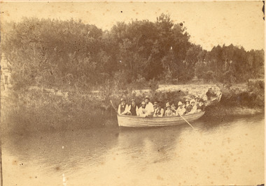
... The Brown family increased their land holding until they held a major part of the farmland between Mordialloc Creek to almost the Aspendale Railway Station. The property was a market garden and orchard. ...The Brown family increased their land holding until they held a major part of the farmland between Mordialloc Creek to almost the Aspendale Railway Station. The property was a market garden and orchard. ...The members of the Brown family in a rowing boat on Mordialloc Creek. Hugh Brown (1830-1930), born in Ireland, arrived in Adelaide in 1855 and in the Mordialloc district in 1856. Mr Brown brought land in 1866 and built his farmhouse “Pine Vale” in 1870 near the site of the present Mordialloc Secondary College (then part of the property) and extended his property when the swampland was made open for selection in 1871. The property was a market garden and orchard. Hugh Brown married Zillah Baxter (1866) and they had six sons, five living to adulthood. The Brown family increased their land holding until they held a major part of the farmland between Mordialloc Creek to almost the Aspendale Railway Station. The property was a market garden and orchard. Mr Brown took an active interest in the public life of the community, a Justice of the Peace; Councillor of Dandenong Shire for over 30 years, was twice Shire President; and a founding member of the Mordialloc Mechanics Institute. Sepia photo of a adults in a large rowing boat on Mordialloc Creek, Mordialloc.hugh brown, mordialloc, pioneer, pine vale, mordialloc creek, row boat -
 Chelsea & District Historical Society Inc
Photograph - Brown's Paddock, A game of cricket at Mr Hugh Brown's Farm
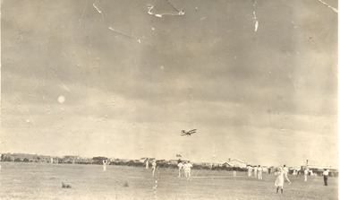
... The Brown family increased their land holding until they held a major part of the farmland between Mordialloc Creek to almost the Aspendale Railway Station. The property was a market garden and orchard. ...The Brown family increased their land holding until they held a major part of the farmland between Mordialloc Creek to almost the Aspendale Railway Station. The property was a market garden and orchard. ...A cricket game in the paddocks of Mr Hugh Brown farm. Hugh Brown (1830-1930), born in Ireland, arrived in Adelaide in 1855 and in the Mordialloc district in 1856. Mr Brown brought land in 1866 and built his farmhouse “Pine Vale” in 1870 near the site of the present Mordialloc Secondary College (then part of the property) and extended his property when the swampland was made open for selection in 1871. The property was a market garden and orchard. Hugh Brown married Zillah Baxter (1866) and they had six sons, five living to adulthood. The Brown family increased their land holding until they held a major part of the farmland between Mordialloc Creek to almost the Aspendale Railway Station. The property was a market garden and orchard. Mr Brown took an active interest in the public life of the community, a Justice of the Peace; Councillor of Dandenong Shire for over 30 years, was twice Shire President; and a founding member of the Mordialloc Mechanics Institute. Black and white studio photo of a cricket game in the paddock Mr Hugh Brown's farm. Farm houses and sheds in the background. A biplane flying overhead.hugh brown, mordialloc, pioneer, pine vale, farm, cricket, biplane, paddock, farm house -
 Chelsea & District Historical Society Inc
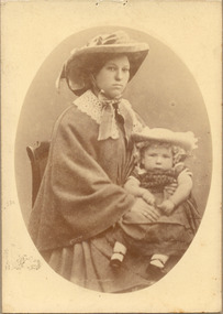
Photograph - Mr Hugh Brown and descendants, Zillah Brown nursing her son Thomas, c 1860's
... The Brown family increased their land holding until they held a major part of the farmland between Mordialloc Creek to almost the Aspendale Railway Station. The property was a market garden and orchard. ...The Brown family increased their land holding until they held a major part of the farmland between Mordialloc Creek to almost the Aspendale Railway Station. The property was a market garden and orchard. ...Zillah Brown (nee Baxter), was the wife of a pioneer of the district, Mr Hugh Brown. Hugh Brown (1830-1930), born in Ireland, arrived in Adelaide in 1855 and in the Mordialloc district in 1856. Mr Brown brought land in 1866 and built his farmhouse “Pine Vale” in 1870 near the site of the present Mordialloc Secondary College (then part of the property) and extended his property when the swampland was made open for selection in 1871. The property was a market garden and orchard. Hugh Brown married Zillah Baxter (1866) and they had six sons, five living to adulthood. The Brown family increased their land holding until they held a major part of the farmland between Mordialloc Creek to almost the Aspendale Railway Station. The property was a market garden and orchard. Mr Brown took an active interest in the public life of the community, a Justice of the Peace; Councillor of Dandenong Shire for over 30 years, was twice Shire President; and a founding member of the Mordialloc Mechanics Institute. Black and white studio photo of Mrs Zillah Brown and her son, Thomas. Mrs Brown was the wife of Mr Hugh Brown.University Studios 306 Lygon St. Carltonhugh brown, mordialloc, pioneer, zillah brown, zillah baxter, pine vale -
 Chelsea & District Historical Society Inc
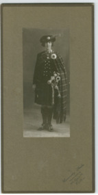
Photograph - Mr Hugh Brown and descendants, Jean Brown in Highland Dress, 1924
... The Brown family increased their land holding until they held a major part of the farmland between Mordialloc Creek to almost the Aspendale Railway Station. The property was a market garden and orchard. ...The Brown family increased their land holding until they held a major part of the farmland between Mordialloc Creek to almost the Aspendale Railway Station. The property was a market garden and orchard. ...Zillah Jean Brown, known as Jean, was the granddaughter of a pioneer of the district, Mr Hugh Brown. Hugh Brown (1830-1930), born in Ireland, arrived in Adelaide in 1855 and in the Mordialloc district in 1856. Mr Brown brought land in 1866 and built his farmhouse “Pine Vale” in 1870 near the site of the present Mordialloc Secondary College (then part of the property) and extended his property when the swampland was made open for selection in 1871. The property was a market garden and orchard. Hugh Brown married Zillah Baxter (1866) and they had six sons, five living to adulthood. The Brown family increased their land holding until they held a major part of the farmland between Mordialloc Creek to almost the Aspendale Railway Station. The property was a market garden and orchard. Mr Brown took an active interest in the public life of the community, a Justice of the Peace; Councillor of Dandenong Shire for over 30 years, was twice Shire President; and a founding member of the Mordialloc Mechanics Institute. Black and white photo of Miss Jean Brown in highland dress with bagpipes.University Studios 306 Lygon St. Carltonhugh brown, mordialloc, jean brown, highland dress, costumes, bagpipes -
 Chelsea & District Historical Society Inc
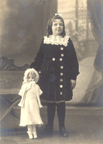
Photograph - Mr Hugh Brown and descendants, Jean Brown, 1918
... The Brown family increased their land holding until they held a major part of the farmland between Mordialloc Creek to almost the Aspendale Railway Station. The property was a market garden and orchard. ...The Brown family increased their land holding until they held a major part of the farmland between Mordialloc Creek to almost the Aspendale Railway Station. The property was a market garden and orchard. ...Zillah Jean Brown, known as Jean, was the granddaughter of a pioneer of the district, Mr Hugh Brown. Hugh Brown (1830-1930), born in Ireland, arrived in Adelaide in 1855 and in the Mordialloc district in 1856. Mr Brown brought land in 1866 and built his farmhouse “Pine Vale” in 1870 near the site of the present Mordialloc Secondary College (then part of the property) and extended his property when the swampland was made open for selection in 1871. The property was a market garden and orchard. Hugh Brown married Zillah Baxter (1866) and they had six sons, five living to adulthood. The Brown family increased their land holding until they held a major part of the farmland between Mordialloc Creek to almost the Aspendale Railway Station. The property was a market garden and orchard. Mr Brown took an active interest in the public life of the community, a Justice of the Peace; Councillor of Dandenong Shire for over 30 years, was twice Shire President; and a founding member of the Mordialloc Mechanics Institute. Black and white studio photo of Miss Jean Brown with a doll.The Yeoman Studioshugh brown, mordialloc, jean brown, zillah brown, doll