Showing 13 items matching "australian army cessna"
-
 Wangaratta RSL Sub Branch
Souvenir - Propeller, McCauley
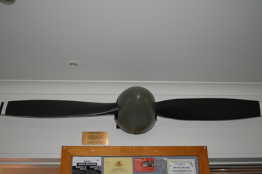
... ...australian army cessna...Australian Army Cessna 180 A98-044 which suffered bullet damage whilst operating from Bien Hoa South Vietnam on 6th July, 1968...Plaque - This Propeller powered Australian Army Cessna 180 A98-044 It suffered bullet damage whilst operating from Bien Hoa South Vietnam on 6th July, 1968 Pilot 2nd Lt Steve TIZZARD Observer Lt Kev LUNNY...Wangaratta RSL Sub Branch 2-4 Templeton Street Wangaratta high-country Australian Army Cessna 180 A98-044 which suffered bullet damage whilst operating from Bien Hoa South Vietnam on 6th July, 1968 vietnam war bien hoa australian army cessna Plaque - This Propeller powered Australian Army Cessna 180 A98-044 It suffered bullet damage whilst operating from Bien Hoa South Vietnam on 6th July, 1968 Pilot 2nd Lt Steve TIZZARD Observer Lt Kev LUNNY Two black wide narrow shaped wings with white strip on ends either side of round grey nose centerpiece. ...Australian Army Cessna 180 A98-044 which suffered bullet damage whilst operating from Bien Hoa South Vietnam on 6th July, 1968Two black wide narrow shaped wings with white strip on ends either side of round grey nose centerpiece.Plaque - This Propeller powered Australian Army Cessna 180 A98-044 It suffered bullet damage whilst operating from Bien Hoa South Vietnam on 6th July, 1968 Pilot 2nd Lt Steve TIZZARD Observer Lt Kev LUNNYvietnam war, bien hoa, australian army cessna -
 Wangaratta RSL Sub Branch
Administrative record - Book, Propeller Log Book, 1967
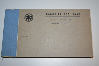
... ...australian army cessna...Australian Army Cessna used during Vietnam War - Logbook contains service history between 1/5/1978 to 28/1/2011 when propeller was removed from aircraft. ...Wangaratta RSL Sub Branch 2-4 Templeton Street Wangaratta high-country Australian Army Cessna used during Vietnam War - Logbook contains service history between 1/5/1978 to 28/1/2011 when propeller was removed from aircraft. ...Australian Army Cessna used during Vietnam War - Logbook contains service history between 1/5/1978 to 28/1/2011 when propeller was removed from aircraft. Contained inside sleeve attached to inside rear cover is cardboard record detailing service history between 17/7/1967 and 6/8/1974Grey cardboard book with spine bound in blue fabricSymbol containing Department of Transport Australia Propeller Log Book Serial No 61209 Log Book No Onelogbook, australian army cessna, vietnam war -
 National Vietnam Veterans Museum (NVVM)
Photograph, Cessna 180 D
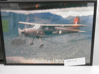
... Coloured Photograph in a black frame of Australian Army Cessna 180D in flight....National Vietnam Veterans Museum (NVVM) 25 Veterans Drive Newhaven phillip-island-and-the-bass-coast Photograph Planes Cessna 180 Army Rondel S/N A98 - 150 Coloured Photograph in a black frame of Australian Army Cessna 180D in flight. ...Coloured Photograph in a black frame of Australian Army Cessna 180D in flight.Army Rondel S/N A98 - 150photograph, planes, cessna 180 -
 National Vietnam Veterans Museum (NVVM)
Photograph, Gibbons, Denis, Cessna Aircraft
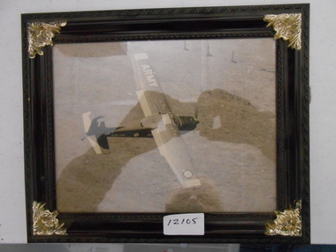
... A black and white photograph of an Australian Army Cessna fixed wing reconnaissance aircraft from 161 (Indep) Recce Flight conducting low level sweeps of the jungle in Phuoc Tuy searching for signs of NVA/VietCong operating in the area.... NVA/VC Phuoc Tuy Australian Army 161 (Indep) Recce Flt Jungle NVA/VietCong Denis Gibbons A black and white photograph of an Australian Army Cessna fixed wing reconnaissance aircraft from 161 (Indep) Recce Flight conducting low level sweeps of the jungle in Phuoc Tuy searching for signs of NVA/VietCong operating in the area. ...Denis Gibbons (1937 – 2011) Trained with the Australian Army, before travelling to Vietnam in January 1966, Denis stayed with the 1st Australian Task Force in Nui Dat working as a photographer. For almost five years Gibbons toured with nine Australian infantry battalions, posting compelling war images from within many combat zones before being flown out in late November 1970 after sustaining injuries. The images held within the National Vietnam Veterans Museum make up the Gibbons Collection.A black and white photograph of an Australian Army Cessna fixed wing reconnaissance aircraft from 161 (Indep) Recce Flight conducting low level sweeps of the jungle in Phuoc Tuy searching for signs of NVA/VietCong operating in the area.photograph, 161 recon flt, cessna, nva/vc, phuoc tuy, australian army, 161 (indep) recce flt, jungle, nva/vietcong, denis gibbons -
 National Vietnam Veterans Museum (NVVM)
Photograph, Cessna 180 Aircraft, 1968
... Photograph of Australian Army 161 Recce Flt Cessna 180 in flight over Vietnam...National Vietnam Veterans Museum (NVVM) 25 Veterans Drive Newhaven phillip-island-and-the-bass-coast Photograph Vietnam Cessna 180 161 Reconnaissance Flight Army Rondell, A98 - 148, Army Photograph of Australian Army 161 Recce Flt Cessna 180 in flight over Vietnam Cessna 180 Aircraft Photograph Photograph ...Photograph of Australian Army 161 Recce Flt Cessna 180 in flight over VietnamArmy Rondell, A98 - 148, Armyphotograph, vietnam, cessna 180, 161 reconnaissance flight -
 Bendigo Military Museum
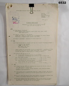
Administrative record - Royal Australian Survey Corps - Central Command Operation Order C/1/61 Northern Territory 1961, DAD Svy, HQ Central Command , Keswick Barracks, SA, 1961
... Australian Survey Corps to conduct a Survey Operation in Northern Territory in 1961. The task is to acquire Survey Control for the production of maps coving the following 1:250 000 map areas of Alligator River, Mt Evelyn, Coburg Peninsula, (including the offshore Islands, Melville Island and Bathurst Island. The Operation Order details the tasks for the 6 x Officers (or equivalent) and 34 x OR's (or equivalent) and the support that was allocated including Frigate HMAS Gasgoyne, LSM landing craft, Trucks amphibian (DUKW), Helicopter and Cessna aircraft. Royal Australian Survey Corps RASvy Fortuna Army ...This is a Central Command Operation Order for the Royal Australian Survey Corps to conduct a Survey Operation in Northern Territory in 1961. The task is to acquire Survey Control for the production of maps coving the following 1:250 000 map areas of Alligator River, Mt Evelyn, Coburg Peninsula, (including the offshore Islands, Melville Island and Bathurst Island. The Operation Order details the tasks for the 6 x Officers (or equivalent) and 34 x OR's (or equivalent) and the support that was allocated including Frigate HMAS Gasgoyne, LSM landing craft, Trucks amphibian (DUKW), Helicopter and Cessna aircraft.A 11 x page foolscap size paper report and 1 x foldout map Annex held together with a paper clip. Two hole punched.Hand written File Number in top RH Corner "101-310-4". Distribution stamp in top LH Corner. Hand written No7 in Top RH Corner.royal australian survey corps, rasvy, fortuna, army survey regiment, army svy regt -
 Bendigo Military Museum
Photograph - 4th Field Survey Squadron – Operation MIZMAZE 92, Kimberley region, Western Australia, 1992
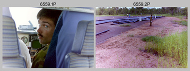
... Cessna 404 Titan Ambassador from Vee-H Aviation was used as the Wild RC10 camera platform for aerial photography acquisition. Royal Australian Survey Corps RASvy 4 Fd Svy Sqn OP MIZMAZE 92 .1P to .40P – There are no personnel identified. ‘1992 OP MIZMAZE annotated on negative sleeve. This is a set of 40 photographs taken in 1992 during 4th Field Survey Squadron’s deployment on Operation MIZMAZE 92 in the Kimberley region of Western Australia. The colour photographs are on 35mm negative film and are part of the Army ...This is a set of 40 photographs taken in 1992 during 4th Field Survey Squadron’s deployment on Operation MIZMAZE 92 in the Kimberley region of Western Australia from the 13th of May to the 14th of July 1992. The area of operations was Wyndham, Halls Creek and Sandfire Flat. It was a two-part operation involving the field completion of topographic maps and the acquisition of mapping control by GPS field parties utilising Texas Instruments TI4100 Global Positioning System receivers. Survey parties conducted field checking of topographic maps and GPS control acquisition in Perentie 110 Series Survey variant FFR Land Rovers. Three Bell Kiowa LOH helicopters provided by 162 Recce Sqn supported field checking and limited deployment of GPS surveys parties. C-l30 Hercules from 36 Sqn supported deployment and extraction of personnel and equipment to and from from the AO. A Cessna 404 Titan Ambassador from Vee-H Aviation was used as the Wild RC10 camera platform for aerial photography acquisition.This is a set of 40 photographs taken in 1992 during 4th Field Survey Squadron’s deployment on Operation MIZMAZE 92 in the Kimberley region of Western Australia. The colour photographs are on 35mm negative film and are part of the Army Survey Regiment’s Collection. The photographs were scanned at 96 dpi. .1) - Photo, colour, 1992. CAPT Craig Hersant. .2) - Photo, colour, 1992. Unidentified officer/soldier. .3) & .4) - Photo, colour, 1992. Aboriginal rock art - Wandjina Gunduran, Donkey Creek. .5) - Photo, colour, 1992. Aboriginal rock art - Track Wandjinas, Donkey Creek. .6) & .7) - Photo, colour, 1992. CAPT Craig Hersant. .8) - Photo, colour, 1992. Kimberley region topography. CPL Glen Weatherell. .9) - Photo, colour, 1992. Unidentified personnel .10) - Photo, colour, 1992. Supermarket at unknown location. .11) to .13) - Photo, colour, 1992. Caravan park at unknown location. .14) - Photo, colour, 1992. Old bridge at Fitzroy Crosssing. .15) & .16) - Photo, colour, 1992. Survey party in Perentie 110 Series Land Rover. .17) & .18) - Photo, colour, 1992. Kimberley region topography. .19) - Photo, colour, 1992. Kimberley region topography. CPL Glen Weatherell. .20) - Photo, colour, 1992. Kimberley region topography, possibly the Bungle Bungles. .21) - Photo, colour, 1992. Kimberley region topography. SGT Frank Downie. .22) - Photo, colour, 1992. Kimberley region topography: the Bungle Bungles. .23) - Photo, colour, 1992. Kimberley region topography: the Bungle Bungles. .24) - Photo, colour, 1992. Kimberley region topography: the Bungle Bungles. SPR Neil Pedler. .25) & .26) - Photo, colour, 1992. Kimberley region topography: the Bungle Bungles. .27) - Photo, colour, 1992. Kimberley region topography. .28) - Photo, colour, 1992. Survey party with Perentie 110 Series Land Rover. .29) - Photo, colour, 1992. Kimberley region topography. .30) - Photo, colour, 1992. Survey party outside Perentie 110 Series Land Rover. .31) & .32) - Photo, colour, 1992. Survey party operating TI4100 GPS Receiver next to Perentie 110 Series Land Rover. SGT Eddie Jacobs. .33) & .34) - Photo, colour, 1992. Survey party operating TI4100 GPS Receiver next to Perentie 110 Series Land Rover. Unidentified surveyor. .35) - Photo, colour, 1992. Kimberley region topography. Hand water pump at well. .36) - Photo, colour, 1992. Survey party in Perentie 110 Series Land Rover. .37) - Photo, colour, 1992. Kimberley region topography. CPL Glen Weatherell. .38) - Photo, colour, 1992. Kimberley region topography viewed from Bell Kiowa LOH helicopter. .39) & .40) - Photo, colour, 1992. Unidentified surveyor field checking a preliminary map in a Bell Kiowa LOH helicopter..1P to .40P – There are no personnel identified. ‘1992 OP MIZMAZE annotated on negative sleeve.royal australian survey corps, rasvy, 4 fd svy sqn, op mizmaze 92 -
 National Vietnam Veterans Museum (NVVM)
Photograph - Colour image, Bunny II
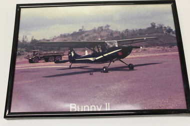
... Australian Army air corps personnel from the 161 Possums using salvaged parts in Vung Tau, Vietnam, in 1970. Dating back to the 1950s, the bunny design on the tail of an aircraft has come to represent the tradition and spirit of Naval Aviation. plane truck tarmac white bunny bunny 11 161 recce birddog cessna bird dog Navy aircraft Bunny 11/ 161/white bunny on tail. ...Bunny II was built by Australian Army air corps personnel from the 161 Possums using salvaged parts in Vung Tau, Vietnam, in 1970. Dating back to the 1950s, the bunny design on the tail of an aircraft has come to represent the tradition and spirit of Naval Aviation.Colored photograph in a black frame. In the foreground on the tarmac is a small black plane with 161 in red near the nose. There is a white strip down the side of the plane. Also has an image of a white bunny on the tail of the plane. The rotors also have a white tip on them. Behind the plane is a truck with a soldier in it. There is a small hill in the background. On the bottom of the photograph reads Bunny 11.Bunny 11/ 161/white bunny on tail. plane, truck, tarmac, white bunny, bunny 11, 161 recce, birddog, cessna, bird dog, navy aircraft -
 National Vietnam Veterans Museum (NVVM)
Photograph, Gibbons, Denis, Possum
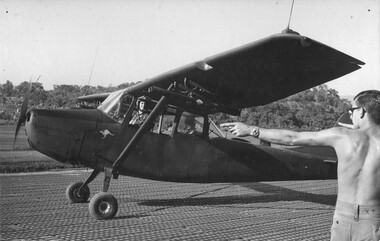
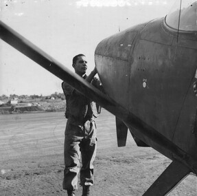
... Australian Army, before travelling to Vietnam in January 1966, Denis stayed with the 1st Australian Task Force in Nui Dat working as a photographer. For almost five years Gibbons toured with nine Australian infantry battalions, posting compelling war images from within many combat zones before being flown out in late November 1970 after sustaining injuries. The images held within the National Vietnam Veterans Museum make up the Gibbons Collection. Photograph Capt Bernie Forrest 161 Recon Flt Phuoc Tuy Gibbons Collection Catalogue 161 (Indep) Recce Flt Jungles of Vietnam NVA/VietCong Denis Gibbons Possum' Cessna ...Denis Gibbons (1937 – 2011) Trained with the Australian Army, before travelling to Vietnam in January 1966, Denis stayed with the 1st Australian Task Force in Nui Dat working as a photographer. For almost five years Gibbons toured with nine Australian infantry battalions, posting compelling war images from within many combat zones before being flown out in late November 1970 after sustaining injuries. The images held within the National Vietnam Veterans Museum make up the Gibbons Collection.A black and white photograph of Capt Bernie Forest in his 161 (Indep) Recce Flt 'Possum' Cessna aircraft is directed to a parking bay by a member of the unit's ground staff, following an extended mission over the jungles of Phuoc Tuy searching for signs of NVA/VietCong operations.photograph, capt bernie forrest, 161 recon flt, phuoc tuy, gibbons collection catalogue, 161 (indep) recce flt, jungles of vietnam, nva/vietcong, denis gibbons, possum' cessna aircraft -
 National Vietnam Veterans Museum (NVVM)
Photograph, Gibbons, Denis, Rockets
... Australian Army, before travelling to Vietnam in January 1966, Denis stayed with the 1st Australian Task Force in Nui Dat working as a photographer. For almost five years Gibbons toured with nine Australian infantry battalions, posting compelling war images from within many combat zones before being flown out in late November 1970 after sustaining injuries. The images held within the National Vietnam Veterans Museum make up the Gibbons Collection. Photograph 161 Recon Flt 2lt Tom "Rockets" Guivarra 1st ATF Base Cessna ...Denis Gibbons (1937 – 2011) Trained with the Australian Army, before travelling to Vietnam in January 1966, Denis stayed with the 1st Australian Task Force in Nui Dat working as a photographer. For almost five years Gibbons toured with nine Australian infantry battalions, posting compelling war images from within many combat zones before being flown out in late November 1970 after sustaining injuries. The images held within the National Vietnam Veterans Museum make up the Gibbons Collection.A black and white photograph of 2Lt Tom 'Rockets' Guivarra , a fixed wing pilot with 161 (Indep) Recce Flt at the 1st Australian Task Force Base, Nui Dat, checks the engine of his Cessna Aircraft prior to a mission, over the jungle of Phuoc Tuy Province, South Vietnamphotograph, 161 recon flt, 2lt tom "rockets" guivarra, 1st atf base, cessna, phuoc tuy province, nui dat, fixed wing pilot, 161 (indep) recce flt, 1st australian task force, jungle, denis gibbons -
 National Vietnam Veterans Museum (NVVM)
Photograph, Gibbons, Denis, Routine Maintenance
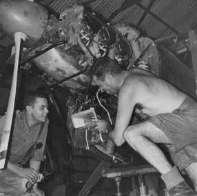
... Australian Army, before travelling to Vietnam in January 1966, Denis stayed with the 1st Australian Task Force in Nui Dat working as a photographer. For almost five years Gibbons toured with nine Australian infantry battalions, posting compelling war images from within many combat zones before being flown out in late November 1970 after sustaining injuries. The images held within the National Vietnam Veterans Museum make up the Gibbons Collection. Photograph 161 Recon Flt 2lt Tom "Rockets" Guivarra Cessna ...Denis Gibbons (1937 – 2011) Trained with the Australian Army, before travelling to Vietnam in January 1966, Denis stayed with the 1st Australian Task Force in Nui Dat working as a photographer. For almost five years Gibbons toured with nine Australian infantry battalions, posting compelling war images from within many combat zones before being flown out in late November 1970 after sustaining injuries. The images held within the National Vietnam Veterans Museum make up the Gibbons Collection.A black and white photograph of 2Lt Tom 'Rockets' Guivarra, a fixed wing pilot with 161 (Indep) Recce Flt checks with a maintenance technician during routine maintenance on one of the flights Cessna fixed wing aircraft's engines. (Circa April 1967)photograph, 161 recon flt, 2lt tom "rockets" guivarra, cessna, gibbons collection catalogue, fixed wing pilot, 161 (indep) recce flt, denis gibbons -
 National Vietnam Veterans Museum (NVVM)
Photograph, Another Recce Mission
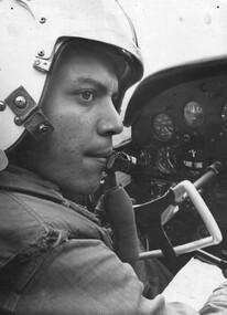
... Australian Army, before travelling to Vietnam in January 1966, Denis stayed with the 1st Australian Task Force in Nui Dat working as a photographer. For almost five years Gibbons toured with nine Australian infantry battalions, posting compelling war images from within many combat zones before being flown out in late November 1970 after sustaining injuries. The images held within the National Vietnam Veterans Museum make up the Gibbons Collection. Photograph 2lt Tom "Rockets" Guivarra 161 Recon Flt Cessna ...Denis Gibbons (1937 – 2011) Trained with the Australian Army, before travelling to Vietnam in January 1966, Denis stayed with the 1st Australian Task Force in Nui Dat working as a photographer. For almost five years Gibbons toured with nine Australian infantry battalions, posting compelling war images from within many combat zones before being flown out in late November 1970 after sustaining injuries. The images held within the National Vietnam Veterans Museum make up the Gibbons Collection.A black and white photograph of 2Lt Tom 'Rockets' Guivarra, a fixed wing pilot with 161 (Indep) Recce Flight at the controls of his Cessna fixed wing aircraft, as he carries out yet another mission over the jungle of Phuoc Tuy Province searching for signs of NVA/VietCong operations.photograph, 2lt tom "rockets" guivarra, 161 recon flt, cessna, phuoc tuy province, nva/vc, gibbons collection catalogue, 161 (indep) recce flt, fixed wing pilot, jungle, nva/vietcong, denis gibbons -
 National Vietnam Veterans Museum (NVVM)
Painting, Jade & Possum Phuoc Tuy 1969, 2001
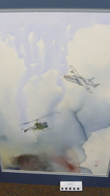
... Cessna 0-2A supporting A/An Army Bell Helicopter in 1969 in Phuoc Tuy Province. Call sings Jade and Possum respectively. The scene portrayed in the watercolour is of a USAF Cessna 0-2A aircraft supporting an Australian Army Bell 47 helicopter in 1969. the team operated in Phuoc Tuy Province in support of the 1st australian Task Force. the 0-2A was a Forward Air Control aircraft flown by both USAF and RAAF pilips in this role. ...Cessna 0-2A supporting A/An Army Bell Helicopter in 1969 in Phuoc Tuy Province. Call sings Jade and Possum respectively. The scene portrayed in the watercolour is of a USAF Cessna 0-2A aircraft supporting an Australian Army Bell 47 helicopter in 1969. the team operated in Phuoc Tuy Province in support of the 1st australian Task Force. the 0-2A was a Forward Air Control aircraft flown by both USAF and RAAF pilips in this role. ...David Robson has had a lifelong association with aircraft. He started flying at the age of 16 and served for 21 years in the RAAF as a fighter pilot, test pilot and forward air controller (including a tour in Vietnam in the 0-2A). His hobby is painting, and he naturally turns to his own experiences and visual images to convey the wonders and beauty of flight, the camaraderie of the Services and ugliness of war.Original watercolour of USAF Cessna 0-2A supporting A/An Army Bell Helicopter in 1969 in Phuoc Tuy Province. Call sings Jade and Possum respectively. The scene portrayed in the watercolour is of a USAF Cessna 0-2A aircraft supporting an Australian Army Bell 47 helicopter in 1969. the team operated in Phuoc Tuy Province in support of the 1st australian Task Force. the 0-2A was a Forward Air Control aircraft flown by both USAF and RAAF pilips in this role. Jade 07 was the callsign reserved for a RAAF fighter pilot. As well as directing airstrikes in the Jad FAC gave top cover and navigational assistance to the Possum helicopter and , in return, the Possum provided very accurate BDA (Bomb Damage Assesment) following the airstrike.Signed by Artist David Robson 2001. cessna 0-2a, painting, phuoc tuy, david robson