Showing 11 items matching "bacchus marsh region parish plans"
-
 Bacchus Marsh & District Historical Society
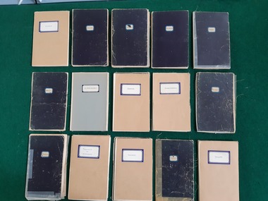
Map, Bacchus Marsh Region Parish Plans: Folded set of maps
... Bacchus Marsh Region Parish Plans: Folded set of maps...Bacchus Marsh & District Historical Society Lerderderg Library Main Street Bacchus Marsh Maps Bacchus Marsh Region Bacchus Marsh Victoria Maps Set of Victorian Lands Department Parish Plans covering the township of Bacchus Marsh and surrounding districts. ...Set of Victorian Lands Department Parish Plans covering the township of Bacchus Marsh and surrounding districts. Folded. BMDHS Location: AR/SU27/D2: Map Drawersmaps bacchus marsh region, bacchus marsh victoria maps -
 Bacchus Marsh & District Historical Society
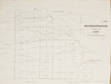
Map, Mooradoranook Parish Map, County of Grant
... ...Bacchus Marsh Region Parish Plans...Bacchus Marsh & District Historical Society Lerderderg Library Main Street Bacchus Marsh Mooradoranook Parish Maps Mooradoranook Parish Plan Bacchus Marsh Region Parish Plans Photo lithographed at the Department of Lands and Survey Melbourne by T. ...A single page paper map showing the map for the Parish of Mooradanook in the County of Grant. Cadastral map showing land ownership. The map is pasted into a bound volume containing 76 maps or plans in total. High resolution digital image stored on BMDHS computer network. Photo lithographed at the Department of Lands and Survey Melbourne by T. F. McGauran, 27.11.06mooradoranook parish maps, mooradoranook parish plan, bacchus marsh region parish plans -
 Bacchus Marsh & District Historical Society
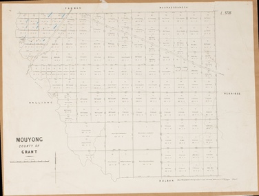
Map, Mouyong Parish Map, County of Grant
... ...Bacchus Marsh Region Parish Plans...Bacchus Marsh & District Historical Society Lerderderg Library Main Street Bacchus Marsh Mouyong Parish Plan Mouyong Parish Maps Bacchus Marsh Region Parish Plans Photo lithographed at the Department of Lands and Survey Melbourne by T. ...A single page paper map showing the map for the Parish of Mouyong in the County of Grant. Cadastral map showing land ownership. The map is pasted into a bound volume containing 76 maps or plans in total. High resolution digital image stored on BMDHS computer network. Photo lithographed at the Department of Lands and Survey Melbourne by T. F. McGauran, 9. 4. 07mouyong parish plan, mouyong parish maps, bacchus marsh region parish plans -
 Bacchus Marsh & District Historical Society
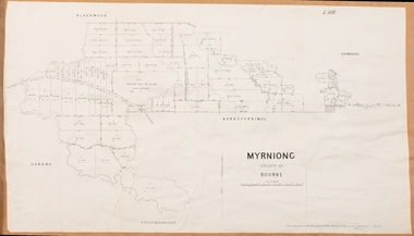
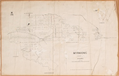
Map, Myrniong Parish Map 1904
... ...Bacchus Marsh Region Parish Plans...Bacchus Marsh & District Historical Society Lerderderg Library Main Street Bacchus Marsh Myrniong Parish Plan Myrniong Parish Maps Bacchus Marsh Region Parish Plans A single page paper map showing the map for the Parish of Myrniong in the County of Bourke. ...A single page paper map showing the map for the Parish of Myrniong in the County of Bourke. A cadastral map showing parish boundaries and land ownership. The map is pasted into a bound volume containing 76 maps or plans in total. High resolution digital image stored on BMDHS computer network. myrniong parish plan, myrniong parish maps, bacchus marsh region parish plans -
 Bacchus Marsh & District Historical Society
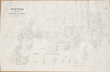
Map, Trentham Parish Map 1905 Copy 1
... ...Bacchus Marsh Region Parish Plans...Bacchus Marsh & District Historical Society Lerderderg Library Main Street Bacchus Marsh Trentham Parish Maps Trentham Parish Plan Bacchus Marsh Region Parish Plans Photo-lithographed at the Department of Lands and Survey, Melbourne by T.F. ...A single page paper map showing the map for the Parish of Trentham in the Counties of Dalhousie and Bourke. A cadastral map showing parish boundaries and land ownership. The map is pasted into a bound volume containing 76 maps or plans in total. High resolution digital image stored on BMDHS computer network. Photo-lithographed at the Department of Lands and Survey, Melbourne by T.F. McGauran 22.3.05 trentham parish maps, trentham parish plan, bacchus marsh region parish plans -
 Bacchus Marsh & District Historical Society
Map, Gorrockburkchap Parish Map, County of Grant c.1906
... ...Bacchus Marsh Region Parish Plans...Bacchus Marsh & District Historical Society Lerderderg Library Main Street Bacchus Marsh The parish of Gorrockburkchap (sometimes spelled Gorrockburkghap) lies to the west and south west of the township of Bacchus Marsh. The locality of Rowsley is situated within this parish area. Gorrockburkchap Parish Maps Rowsley Victoria Maps Bacchus Marsh Region Parish Plans ...The parish of Gorrockburkchap (sometimes spelled Gorrockburkghap) lies to the west and south west of the township of Bacchus Marsh. The locality of Rowsley is situated within this parish area.A single page paper map showing the parish plan for Gorrockburkchap in the County of Grant. A cadastral map showing parish boundaries and land ownership The map is pasted into a bound volume containing 76 maps or plans in total. High resolution digital image stored on BMDHS computer network. gorrockburkchap parish maps, rowsley victoria maps, bacchus marsh region parish plans -
 Bacchus Marsh & District Historical Society
Map, Myrniong Parish Map, County of Bourke, 1882
... ...Bacchus Marsh Region Parish Plans...Bacchus Marsh & District Historical Society Lerderderg Library Main Street Bacchus Marsh Myrniong Parish Plan Myrniong Parish Maps Bacchus Marsh Region Parish Plans Photo-lithographed at the Department of Lands and Survey, Melbourne by J. ...A single page paper map showing the map for the Parish of Myrniong in the County of Bourke. A cadastral map showing parish boundaries and land ownership. The map is pasted into a bound volume containing 76 maps or plans in total. High resolution digital image stored on BMDHS computer network. Photo-lithographed at the Department of Lands and Survey, Melbourne by J. Noone, 17.7.82myrniong parish plan, myrniong parish maps, bacchus marsh region parish plans -
 Bacchus Marsh & District Historical Society
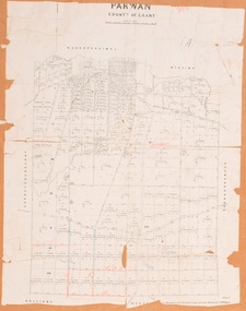
Map, Parwan Parish Map, County of Grant, 1909
... Bacchus Marsh Region Parish Plans...Bacchus Marsh & District Historical Society Lerderderg Library Main Street Bacchus Marsh Bacchus Marsh Region Parish Plans Parwan Parish Maps Parwan Parish Plan Photo-lithographed at the Department of Lands and Survey, Melbourne by T.F. ...A single page paper map showing the map for the Parish of Parwan in the County of Grant. A cadastral map showing parish boundaries and land ownership. The map is pasted into a bound volume containing 76 maps or plans in total. High resolution digital image stored on BMDHS computer network. Photo-lithographed at the Department of Lands and Survey, Melbourne by T.F. McGauran, 7.7.09. bacchus marsh region parish plans, parwan parish maps, parwan parish plan -
 Bacchus Marsh & District Historical Society
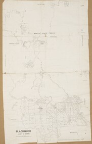
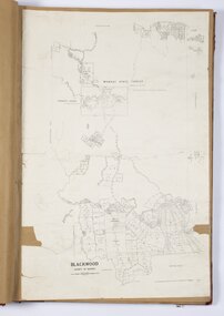
Map, Blackwood Parish Map, County of Bourke, 1892
... Bacchus Marsh Region Parish Plans...Bacchus Marsh & District Historical Society Lerderderg Library Main Street Bacchus Marsh Bacchus Marsh Region Parish Plans Blackwood Parish Plan Blackwood Parish Maps Photo-lithographed at the Department of Lands and Survey, Melbourne by T.F. ...A single page paper map showing the map for the Parish of Blackwood in the County of Bourke. A cadastral map showing parish boundaries and land ownership. The map is pasted into a bound volume containing 76 maps or plans in total. High resolution digital image stored on BMDHS computer network. Photo-lithographed at the Department of Lands and Survey, Melbourne by T.F. McGauran 14.7.92bacchus marsh region parish plans, blackwood parish plan, blackwood parish maps -
 Bacchus Marsh & District Historical Society
Map, Blackwood Parish Map, County of Bourke, 1905
... Bacchus Marsh Region Parish Plans...Bacchus Marsh & District Historical Society Lerderderg Library Main Street Bacchus Marsh Bacchus Marsh Region Parish Plans Blackwood Parish Plan Blackwood Parish Maps Photo-lithographed at the Department of Lands and Survey, Melbourne by T.F. ...A single page paper map showing the map for the Parish of Blackwood in the County of Bourke. A cadastral map showing parish boundaries and land ownership. The map is pasted into a bound volume containing 76 maps or plans in total. High resolution digital image stored on BMDHS computer network. Photo-lithographed at the Department of Lands and Survey, Melbourne by T.F. McGauran 21.7.05bacchus marsh region parish plans, blackwood parish plan, blackwood parish maps -
 Bacchus Marsh & District Historical Society
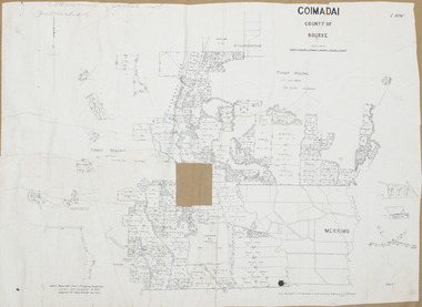
Map, Coimadai Parish Map, County of Bourke. Circa 1890s-1900s
... Bacchus Marsh Region Parish Plans...Bacchus Marsh & District Historical Society Lerderderg Library Main Street Bacchus Marsh The cadastral Parish of Coimadai, a subdivision of the County of Bourke, lies directly north of the township of Bacchus Marsh. The date of this map is uncertain. T.F. McGauran the person who made a photo-lithographic copy of the map was in charge of photo-lithography at the Victorian Department of Lands and Survey in the late 19th century until about 1910. Bacchus Marsh Region Parish Plans ...The cadastral Parish of Coimadai, a subdivision of the County of Bourke, lies directly north of the township of Bacchus Marsh. The date of this map is uncertain. T.F. McGauran the person who made a photo-lithographic copy of the map was in charge of photo-lithography at the Victorian Department of Lands and Survey in the late 19th century until about 1910.A single page paper map showing the map for the Parish of Coimadai in the County of Bourke. A cadastral map showing parish boundaries and land ownership. A rectangle shaped area is missing from the centre of the map due to a tear or deliberate excision. The map is pasted into a bound volume containing 76 maps or plans in total. High resolution digital image stored on BMDHS computer network. Photo-lithographed at the Department of Lands and Survey, Melbourne by T.F. McGauran 26.8.[??] NOTE. Photo litho from L.P showing temporary surveys and occupation of land prepared for departmental use onlybacchus marsh region parish plans, coimadai parish maps, coimadai parish plan