Showing 3 items matching "ballyshanassy shire of nunawading"
-
 Whitehorse Historical Society Inc.
Article, Ballyshanassy
... Ballyshanassy Shire of Nunawading...Whitehorse Historical Society Inc. 2-10 Deep Creek Road Mitcham melbourne Ballyshanassy Shire of Nunawading Bourke Paragraph about Ballyshanassy (County of Bourke) in the Victorian Gazetteer Paragraph about Ballyshanassy (County of Bourke) in the Victorian Gazetteer Ballyshanassy Article Article ...Paragraph about Ballyshanassy (County of Bourke) in the Victorian GazetteerParagraph about Ballyshanassy (County of Bourke) in the Victorian GazetteerParagraph about Ballyshanassy (County of Bourke) in the Victorian Gazetteerballyshanassy shire of nunawading, bourke -
Whitehorse Historical Society Inc.
Article, Great city grew from two villages, 1997
... Ballyshanassy...Box Hill...Shire of Nunawading...City of Nunawading Ballyshanassy Box Hill Shire of Nunawading Parish of Nunawading A brief description on the development of the City of Nunawading from Box Hill and Ballyshanassy. ...A brief description on the development of the City of Nunawading from Box Hill and Ballyshanassy.A brief description on the development of the City of Nunawading from Box Hill and Ballyshanassy. Information was derived from the History of Nunawading by Niall Brennan.A brief description on the development of the City of Nunawading from Box Hill and Ballyshanassy. city of nunawading, ballyshanassy, box hill, shire of nunawading, parish of nunawading -
 Whitehorse Historical Society Inc.
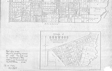
document - Map, Village of Burwood, 1892
... Village of Burwood : old name Ballyshanassy (with southern section of Nunawading). Area bounded by Chapman, Ireland and Evans Streets). Victorian Shire...Village of Burwood : old name Ballyshanassy (with southern section of Nunawading). Area bounded by Chapman, Ireland and Evans Streets). Victorian Shire ...Map on the village of Burwood.Village of Burwood : old name Ballyshanassy (with southern section of Nunawading). Area bounded by Chapman, Ireland and Evans Streets). Victorian Shire Map. co. 26 November 1892. Scale: 8 chains = 1 inch. The full map is reproduced in 'The History of Nunawading' by Niall Brennan, p. 62.Map on the village of Burwood.burwood, land settlement