Showing 12 items matching "bank protection"
-
 Eltham District Historical Society Inc
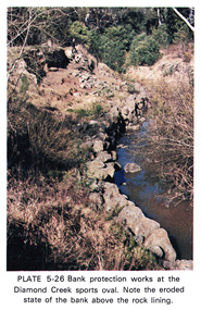
Work on paper (Sub-Item) - Photograph, Bank protection works at the Diamond Creek sports oval
... Bank protection works at the Diamond Creek sports oval...Colour photograph of bank protection works, using large stones at the Diamond Creek Sports oval. ...Eltham District Historical Society Inc 728 Main Rd Eltham melbourne Colour photograph of bank protection works, using large stones at the Diamond Creek Sports oval. ...Colour photograph of bank protection works, using large stones at the Diamond Creek Sports oval. Note the eroded state of the bank above the rock liningeltham, diamond creek, erosion, protection, stone, diamond creek sports oval -
 Eltham District Historical Society Inc
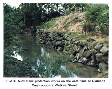
Work on paper (Sub-Item) - Photograph, Bank protection works on the east bank of Diamond Creek opposite Watkins Street
... Bank protection works on the east bank of Diamond Creek opposite Watkins Street...Colour photograph of bank protection works, using bluestone rocks to construct a wall on the east bank of Diamond Creek, to prevent erosion. ...Eltham District Historical Society Inc 728 Main Rd Eltham melbourne Colour photograph of bank protection works, using bluestone rocks to construct a wall on the east bank of Diamond Creek, to prevent erosion. ...Colour photograph of bank protection works, using bluestone rocks to construct a wall on the east bank of Diamond Creek, to prevent erosion. Opposite Watkins Street, Diamond Creek townshipeltham, drain, diamond creek, erosion, watkins street, protection, bluestone, wall -
 Eltham District Historical Society Inc
Book, Diamond Creek Basin Study. Part 1, A Compendium of Factors Relevant to Stormwater Flows, 1980
... ...bank protection...Eltham District Historical Society Inc 728 Main Rd Eltham melbourne Basin Studies are studies to evaluate water supply and demand and help ensure reliable water supplies by identifying strategies to address imbalances in water supply and demand. aerial photographs allendale road arthurs creek mine arthurs creek road bridge arthurs creek bald spur look-out bank protection bolton steet bridge street bridge bridge street bridges challenger street chute street construction coolaroo drive culvert deep creek diamond creek basin diamond creek region diamond creek diamond street bridge drainage works eltham lower park eltham town park eltham trestle bridge eltham west drains eltham erosion flood management floods footbridge glen katherine estate gold mining gum glade hurstbridge kangaroo ground kinglake escarpment kinglake national park latiners hat factory main road bridge main road masons falls melbourne metropolitan board of works, monash bridge mount sugarloaf nillumbik park orchards railway culvert railway line ramptons road real estate advertisement research creek st helena east drain st helena road st helena storm sewers stormwater sugarloaf-preston transfer main crossing susan street union mine village pond water flow watkins street wattletree road weidlich road wingrove park yarra river zig zag road water supply basin study Spiral Bound. 157 leaves in various foliations (some folded) : illustrated. ...Basin Studies are studies to evaluate water supply and demand and help ensure reliable water supplies by identifying strategies to address imbalances in water supply and demand.Spiral Bound. 157 leaves in various foliations (some folded) : illustrated. (some colour.), maps (some colour.)aerial photographs, allendale road, arthurs creek mine, arthurs creek road bridge, arthurs creek, bald spur look-out, bank protection, bolton steet, bridge street bridge, bridge street, bridges, challenger street, chute street, construction, coolaroo drive, culvert, deep creek, diamond creek basin, diamond creek region, diamond creek, diamond street bridge, drainage works, eltham lower park, eltham town park, eltham trestle bridge, eltham west drains, eltham, erosion, flood management, floods, footbridge, glen katherine estate, gold mining, gum glade, hurstbridge, kangaroo ground, kinglake escarpment, kinglake national park, latiners hat factory, main road bridge, main road, masons falls, melbourne metropolitan board of works, monash bridge, mount sugarloaf, nillumbik park, orchards, railway culvert, railway line, ramptons road, real estate advertisement, research creek, st helena east drain, st helena road, st helena, storm sewers, stormwater, sugarloaf-preston transfer main crossing, susan street, union mine, village pond, water flow, watkins street, wattletree road, weidlich road, wingrove park, yarra river, zig zag road, water supply, basin study -
 Warrnambool and District Historical Society Inc.
Document, Docket Dr Bright's Phosphodyne, Mid 19th century
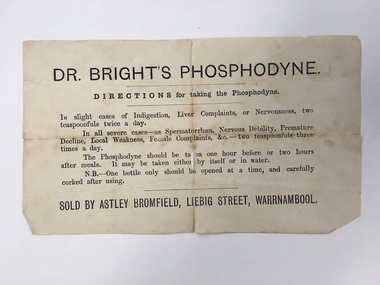
... He was a Justice of the Peace, a Trustee of the Savings Bank, Chairman of the Western Steam Navigation Company, a Director of the Gasworks and on the committees of the Harbour Committee, the Fire Brigade and the Anglers Protection Society. ...This label accompanied a bottle of Dr Bright’s Phosphodyne. It was a form of medicine also known as ozonic oxygen which was developed and patented in 1869 by Dr Charles Bright, a 19th century Resident Surgeon at St Mary’s Hospital London, The medicine claimed to ease ‘indigestion, liver complaints, nervous debility, female complaints, premature decline, local weakness and spermatorrhea’. It was widely sold by chemists throughout Australia in the 19th century and in this case was supplied by the Warrnambool chemist, James Astley Bromfield. He was a significant person in Warrnambool’s history as he produced the 1856 map of the Warrnambool district showing all the original landholders, a seminal resource for historians today. Bromfield had a chemist shop in Warrnambool from 1854 to the late 1880s, initially in Timor Street and then in Liebig Street (number 80 and later number 78). Bromfield was very active in local community affairs. This label is of considerable interest as it shows the use in the 19th century of medicine that today would be labelled ‘quack’. It is of particular interest as it was supplied by James Astley Bromfield’s chemist shop and he is an important early identity in Warrnambool, involved in many activities in the town. He was a Justice of the Peace, a Trustee of the Savings Bank, Chairman of the Western Steam Navigation Company, a Director of the Gasworks and on the committees of the Harbour Committee, the Fire Brigade and the Anglers Protection Society. He was a Warrnambool Councillor (1858-60; 1865-1870) and a Shire Councillor (1875-1883). This is a sheet of paper that accompanied a bottle of Dr Brights’ Phosphodyne medicine. It is buff-coloured with black printed material. It is in two pieces and dog-eared at the edges.warrnambool, dr bright's phosphodyne, james bromfield chemist, warrnambool chemists -
 Glen Eira Historical Society
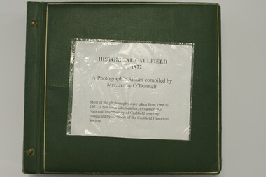
Album, Caulfield Historical Society Photograph Album 1972, 1972
... protection of a National Trust Classification. Principal photographer thought to be Trevor Hart, member of Caulfield Historical Society. Most photographs were taken between 1966-1972 with a small number of photographs being older and from unknown sources. All photographs are black and white except where stated. caulfield photographs photo album trevor hart jenny o'donnell jenny odonnell caulfield historical society glen eira historical society carnegie caulfield east caulfield north caulfield south elsternwick murrumbeena st kilda east houses mansions churches schools halls shops post offices cinemas town halls hotels banks vicarages bridges gates convents bowling clubs fire stations roads and streets caulfield historical album 1970's national trust of australia city of caulfield glen eira city council national trust of australia (victoria) Photo album of buildings in Caulfield circa 1972 compiled alongside a project to assist National Trust Australia (Victoria) in identifying buildings worthy of preservation. ...This album was created in approximately 1972 as part of a project by the Caulfield Historical Society to assist in identifying buildings worthy of preservation. The album is related to a Survey the Caulfield Historical Society developed in collaboration with the National Trust of Australia (Victoria) and Caulfield City Council to identify historic buildings within the City of Caulfield that warranted the protection of a National Trust Classification. Principal photographer thought to be Trevor Hart, member of Caulfield Historical Society. Most photographs were taken between 1966-1972 with a small number of photographs being older and from unknown sources. All photographs are black and white except where stated.Photo album of buildings in Caulfield circa 1972 compiled alongside a project to assist National Trust Australia (Victoria) in identifying buildings worthy of preservation. All photos are black and white except where stated, with 386 photographs over 198 pages. Label on front is longstanding but not original or confirmed.caulfield, photographs, photo album, trevor hart, jenny o'donnell, jenny odonnell, caulfield historical society, glen eira historical society, carnegie, caulfield east, caulfield north, caulfield south, elsternwick, murrumbeena, st kilda east, houses, mansions, churches, schools, halls, shops, post offices, cinemas, town halls, hotels, banks, vicarages, bridges, gates, convents, bowling clubs, fire stations, roads and streets, caulfield historical album, 1970's, national trust of australia, city of caulfield, glen eira city council, national trust of australia (victoria) -
 Glen Eira Historical Society
Album - Album page, Hawthorn Road, Circa 1972
... protection of a National Trust Classification. Principal photographer thought to be Trevor Hart, member of Caulfield Historical Society. Most photographs were taken between 1966-1972 with a small number of photographs being older and from unknown sources. All photographs are black and white except where stated, with 386 photographs over 198 pages. 17 Hawthorn Road, North Caulfield is a contributory building to HO14 Caulfield North and environs, Caulfield North - Heritage Precinct in the City of Glen Eira. trevor hart caulfield hawthorn road verandahs houses shops banks state savings bank caulfield west caulfield north tudor style victorian style Handwritten: 17 HAWTHORN ROAD [under top left photo] / 17 HAWTHORN ROAD [under middle left photo] / 17 HAWTHORN ROAD [under bottom left photo] / 158-162 HAWTHORN ROAD [under top right photo] // STATE SAVINGS BANK CAULFIELD WEST BRANCH / 144 HAWTHORN RD / WEST SIDE - SOUTH OFF BALACLAVA ROAD [under bottom right photo] / 83 [bottom left] Page 83 of Photograph Album with five portrait photographs of 3 different properties on Hawthorn Road. ...This photograph is part of the Caulfield Historical Album 1972. This album was created in approximately 1972 as part of a project by the Caulfield Historical Society to assist in identifying buildings worthy of preservation. The album is related to a Survey the Caulfield Historical Society developed in collaboration with the National Trust of Australia (Victoria) and Caulfield City Council to identify historic buildings within the City of Caulfield that warranted the protection of a National Trust Classification. Principal photographer thought to be Trevor Hart, member of Caulfield Historical Society. Most photographs were taken between 1966-1972 with a small number of photographs being older and from unknown sources. All photographs are black and white except where stated, with 386 photographs over 198 pages. 17 Hawthorn Road, North Caulfield is a contributory building to HO14 Caulfield North and environs, Caulfield North - Heritage Precinct in the City of Glen Eira.Page 83 of Photograph Album with five portrait photographs of 3 different properties on Hawthorn Road. Addresses are handwritten underneath each property.Handwritten: 17 HAWTHORN ROAD [under top left photo] / 17 HAWTHORN ROAD [under middle left photo] / 17 HAWTHORN ROAD [under bottom left photo] / 158-162 HAWTHORN ROAD [under top right photo] // STATE SAVINGS BANK CAULFIELD WEST BRANCH / 144 HAWTHORN RD / WEST SIDE - SOUTH OFF BALACLAVA ROAD [under bottom right photo] / 83 [bottom left] trevor hart, caulfield, hawthorn road, verandahs, houses, shops, banks, state savings bank, caulfield west, caulfield north, tudor style, victorian style -
 Federation University Historical Collection
Photograph (black & White), Modder River - South Africa
... Instead of relying on the hills for protection and missing their targets, de la Rey proposed they make use of the flat veld and introduced them to the Mauser rifle with its flat trajectory. Trenches were built in the banks...Instead of relying on the hills for protection and missing their targets, de la Rey proposed they make use of the flat veld and introduced them to the Mauser rifle with its flat trajectory. Trenches were built in the banks ...When war broke out in 1899, and early target for the Boers was the diamond-mining centre of Kimberley. This was located near the point where the Transvaal, Orange Free State and Cape Colony met. General Sir Redvers Buller detached the 1st Division under Lieutenant General Lord Methuen to relieve the Siege of Kimberley. This decision was made partly for reasons of prestige. To capture Kimberley (which contained the famous imperialist and former Prime Minister of Cape Colony, Cecil Rhodes) would be a major propaganda victory for the British. Methuen's force advanced north and won two engagements against the Boers of the Orange Free State. Reinforcements from Transvaal under General Koos de la Rey arrived and he convinced the Boers to follow his plans for attacking the British. Instead of relying on the hills for protection and missing their targets, de la Rey proposed they make use of the flat veld and introduced them to the Mauser rifle with its flat trajectory. Trenches were built in the banks of the Modder River from which they could sweep the veld for a great distance. The trenches were built on the south side of the river and on the smaller Riet River where they meet at Modder River Station. Methuen's force began advancing towards the Modder planning to cross the river. The Boers opened fire and the British troops were unable to find cover on the veld. They had to lay flat so as not to be seen or hit. The British guns pounded the buildings near Modder River Station and the north bank of the river, missing the trenches on the south bank. The battle became a stalemate. The British found an opening on the Boer's right flank at Rosmead ford downstream and drove the Boers out of Rosmead. De la Rey drove them back into a small insecure bridgehead. The Boers feared they were vulnerable and withdrew during the night. Methuen reported that the battle had been "one of the hardest and most trying fights in the annals of the British army". Individual image from photographed poster of tobacco and cigarette cards.boers, diamind-mining, kimberley, transvaal, orange free state, cape colony, sir rdvers buller, lieutenant general lord methuen, siege of kimberley, cecil rhodes, general koos dde la rey, mauser rifle, veld, modder river, modder river station, trenches, riet river, rosmead -
 Ballarat Tramway Museum
Newspaper, The Courier Ballarat, "Many will miss the Tram", "Departing Trams had Celebrity Farewell", 1971
... protection that was not needed. Photograph accompanying the article is of a driver turning the pole at the Victoria St. terminus of tram No. 31. Second clipping, from The Courier, dated 8/9/1971, reports on a collection of historic tram photos in the Commonwealth Bank for the next two weeks, presented by the Tramway Museum Society of Victoria. 1068.2 - full page of The Courier, 23/8/1971, added 10/9/2013 and image added....protection that was not needed. Photograph accompanying the article is of a driver turning the pole at the Victoria St. terminus of tram No. 31. Second clipping, from The Courier, dated 8/9/1971, reports on a collection of historic tram photos in the Commonwealth Bank for the next two weeks, presented by the Tramway Museum Society of Victoria. 1068.2 - full page of The Courier, 23/8/1971, added 10/9/2013 and image added. ...Yields information about the closure of the SEC Ballarat system in particular the Victoria St line. Has a strong association with the article author.Set of two Newspaper clippings pasted onto a single sheet of paper with two Punch holes on the left hand side with one hole through the photograph within the cutting. Clipping from The Courier, Ballarat, Monday, 23/8/1971 (corrected date), of two items in the paper about the closure of the trams in Victoria St. The main item written by a staff reporter recalls the days of travelling regularly on the tram when a student going to and from school, Saturday travelling and as a means of transport. Second item in the same cutting reports on the closure of the Victoria St. route the previous day. Mentions the interest in the trams, the BTPS, and police protection that was not needed. Photograph accompanying the article is of a driver turning the pole at the Victoria St. terminus of tram No. 31. Second clipping, from The Courier, dated 8/9/1971, reports on a collection of historic tram photos in the Commonwealth Bank for the next two weeks, presented by the Tramway Museum Society of Victoria. 1068.2 - full page of The Courier, 23/8/1971, added 10/9/2013 and image added.In red ink in upper right hand corner, "21/8/71" of the first cutting and "8/9/71" in red ink in the top right hand corner of the second cuttingtrams, tramways, closure, victoria st., tmsv, displays -
 Eltham District Historical Society Inc
Journal - Newsletter, Nillumbik Shire Council, Nillumbik News, September 2011
... protection, changes to planning regulations and more. Council Newsletters Nillumbik News Nillumbik Shire Council Shire of Nillumbik Diamond Creek Community Bank Stadium Chris Martin Sarah Hill Bob Mietus Jeanette Davison Jacqueline Felstead Rosemary Cameron Joanne Rockwell Gayle Pohl burgan Living and Learning Nillumbik 24 x 21 cm, double stapled, 28 pages Nillumbik News Journal Newsletter Nillumbik Shire Council ...Quarterly community newsletter, for Spring 2011, produced by the Shire of Nillumbik featuring feature stories on environment sustainability, budget highlights, local festivals, volunteer opportunities, council plans and events, Mayor's report, arts and culture programs, profiles, community calandar, contacts for Councillors, Preparing for summer, including bushfire shelter options or Places of Last resort, managing burgan for fire protection, changes to planning regulations and more.council newsletters, nillumbik news, nillumbik shire council, shire of nillumbik, diamond creek community bank stadium, chris martin, sarah hill, bob mietus, jeanette davison, jacqueline felstead, rosemary cameron, joanne rockwell, gayle pohl, burgan, living and learning nillumbik -
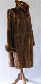 Brighton Historical Society
Clothing - Coat, Water rat fur coat, c.1930s
... The species was placed under a protection order in 1938, although periodic culls were allowed until 1957 due to their perceived destruction of irrigation banks and fishing nets. ...The species was placed under a protection order in 1938, although periodic culls were allowed until 1957 due to their perceived destruction of irrigation banks and fishing nets. ...This coat belonged to Brighton resident Audrey Winifred Pickett (nee Heriot; 1915-2011). The coat is made from the pelts of rakali, also known as the Australian water rat, a native rodent species similar to an otter. Growing up to 35 centimetres in length, rakali typically live in burrows near water, feeding on fish, insects, yabbies and waterbirds. Throughout the early twentieth century, they were widely considered to be a nuisance and were hunted for their soft and waterproof fur. Demand for rakali pelts increased during the 1930s Depression years, when a ban was placed on the import of overseas furs; rakali fur became a popular substitute for the fur of the American muskrat. The species was placed under a protection order in 1938, although periodic culls were allowed until 1957 due to their perceived destruction of irrigation banks and fishing nets. Audrey recalled that the coat was made for her by furrier F. J. Ellemor after a large cull of rakali. The coat was displayed in the window of Ellemor's Block Place store. F. J. Ellemor Pty Ltd was established in 1908 by furrier Francis John Ellemor (1867-1944) and continued into the late twentieth century under the management of his son Wilfred (1801-1972). Francis and his wife Edith lived in Rothesay Avenue, Brighton from the late 1930s.Three-quarter length brown fur coat made of Australian water-rat (rakali) pelts. Wide raised collar and cuffs. Fastens centre front with two large hooks and eyes. Lined with chocolate brown silk satin.Label, woven brown on beige silk, centre back neck: created by / F. J. Ellemor / FURRIERS / MELBOURNEfur coat, rakali, australian water rat, melbourne fashion, audrey winifred heriot, audrey winifred pickett, audrey winifred north, francis john ellemor, f. j. ellemor, furrier -
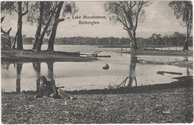 Rutherglen Historical Society
Postcard, Lake Moodemere, Rutherglen, 1900-1908
... He died in April 1908 lake moodemere neddy wheeler dhudhuroa charlotte wheeler thomas wheeler harry wheeler dolly wheeler kate wheeler kiewa valley lake tyres aboriginal protection board Printed at top of photo: "Lake Moodemere, Rutherglen" Black and white photograph, printed on postcard, showing view of Lake Moodemere, with a man wearing a jacket and hat, reclining on the bank in the foreground. ...This photo is of Neddy Wheeler - Dhudhuroa man and language informant to RH Matthews. The photo was taken at Lake Moodemere. Neddy spent the latter part of his life here, especially after his Wife Charlotte and children Thomas, Harry, Dolly and Kate were taken from him in the Kiewa Valley and taken to Lake Tyers.The Aboriginal Protection Board would provide travel passes for him to visit his Country. He died in April 1908Black and white photograph, printed on postcard, showing view of Lake Moodemere, with a man wearing a jacket and hat, reclining on the bank in the foreground.Printed at top of photo: "Lake Moodemere, Rutherglen"lake moodemere, neddy wheeler, dhudhuroa, charlotte wheeler, thomas wheeler, harry wheeler, dolly wheeler, kate wheeler, kiewa valley, lake tyres, aboriginal protection board -
 Bendigo Historical Society Inc.
Newspaper - Fortuna Articles - "Fortuna on the agenda again", Feb 12 2014
... The owner, Paul Banks, has proposed future outdoor concerts and other developments at the historic Fortuna Villa site. Main concerns include noise from events, potential residential development, traffic impacts, and protection of heritage values. ...The owner, Paul Banks, has proposed future outdoor concerts and other developments at the historic Fortuna Villa site. Main concerns include noise from events, potential residential development, traffic impacts, and protection of heritage values. ...Regarding the proposed rezoning and development of Fortuna Villa in Greater Bendigo; six submissions were received about the rezoning proposal: four in support, and two objections. One objection was later withdrawn, leaving one outstanding objection. The owner, Paul Banks, has proposed future outdoor concerts and other developments at the historic Fortuna Villa site. Main concerns include noise from events, potential residential development, traffic impacts, and protection of heritage values. Six residents signed one of the submissions highlighting these issues. The City of Greater Bendigo notes that development restrictions and impact assessment reports will ensure each development is considered individually. Any outdoor events must comply with the council's planning scheme and Environment Protection Authority requirements. The proposal is scheduled for a council vote on Wednesday night.Fortuna Articles - "Fortuna on the agenda again" Feb 12 2014 The Bendigo Weekly This item contains the following: 11217.49a Colour photo of Fortuna Villa 11217.49b Part of Page 11 - Fortuna Articles - "Fortuna on the agenda again"non-fictionbendigo, fortuna, george lansell, paul banks owner fortuna