Showing 6 items matching "basaltic plains of victoria"
-
 Federation University Historical Collection
Document, C.E. Hounam et al, Commonwealth of Australia Bureau of Meteorology - Climate of the Basaltic Plains of Western Victoria, 1963
... Commonwealth of Australia Bureau of Meteorology - Climate of the Basaltic Plains of Western Victoria...basaltic plains of victoria...Symposium - Royal Society of Victoria "Basaltic Plains of Victoria" 12 September 1963...Symposium - Royal Society of Victoria "Basaltic Plains of Victoria" 12 September 1963 Brown cardboard covered foolscap sized typed document with diagrams Commonwealth of Australia Bureau of Meteorology - Climate of the Basaltic Plains of Western Victoria Document C.E. ...Brown cardboard covered foolscap sized typed document with diagrams Handwritten on front. Symposium - Royal Society of Victoria "Basaltic Plains of Victoria" 12 September 1963basaltic plains of victoria, royal society of victoria, commonwealth of australia bureau of meteorology, c.e. hounam, f.a. powell, symposium, maps -
 Merri-bek City Council
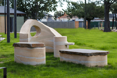
Sculpture - Rammed earth, basalt, mudstone, Isadora Vaughan, Terra Pneumatics, 2021
... The City of Merri-bek and Glenroy lie on the Western Basalt plains of Victoria, with soil and bluestone derived from ancient volcanic lava flows. ...The City of Merri-bek and Glenroy lie on the Western Basalt plains of Victoria, with soil and bluestone derived from ancient volcanic lava flows. ...Located at the Glenroy Community Hub, Isadora Vaughan’s rammed earth and bluestone sculpture draws attention to the continual transformation of Glenroy’s geology and its communities. The City of Merri-bek and Glenroy lie on the Western Basalt plains of Victoria, with soil and bluestone derived from ancient volcanic lava flows. Vaughan’s sculpture is created from these locally found sediments with the range of colours and textures reflecting the changing use of the land as various soils, rocks and sand were introduced from the coastal areas of Victoria. These forms reflect Glenroy’s changing communities, emphasising our relationship with the earth, and have been shaped to enable connection through offering places to sit, lean, play and to gather. Terra Pneumatics embodies the history and sediment of Glenroy —both human and geological — and invites the community to become part of this process of layering and transformation.merri-bek public art collection -
 Sunshine and District Historical Society Incorporated
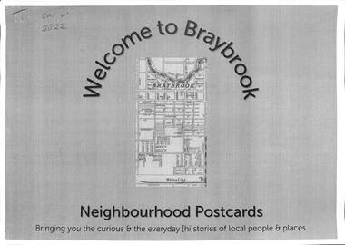
Document - Welcome to Neighbourhood Braybrook Postcards, History At Work Pty Ltd, 2021
... Victoria. Neighbourhood Postcards probes the memories of our local streets for histories of local people whose lives, play, work and pre-occupation have shaped our local communities today. This set features Braybrook, a suburb of Shire of Braybrook and City of Sunshine, prior to the Council mergers in 1996, which created the City of Brimbank. A walking tour map is included that allows one to visit the various points of interest featured in the postcards including The Munition Workers Housing Estate, The basalt plains...Victoria. Neighbourhood Postcards probes the memories of our local streets for histories of local people whose lives, play, work and pre-occupation have shaped our local communities today. This set features Braybrook, a suburb of Shire of Braybrook and City of Sunshine, prior to the Council mergers in 1996, which created the City of Brimbank. A walking tour map is included that allows one to visit the various points of interest featured in the postcards including The Munition Workers Housing Estate, The basalt plains ...History at Work produced a number of Neighbourhood Postcards of various sites throughout Victoria. Neighbourhood Postcards probes the memories of our local streets for histories of local people whose lives, play, work and pre-occupation have shaped our local communities today. This set features Braybrook, a suburb of Shire of Braybrook and City of Sunshine, prior to the Council mergers in 1996, which created the City of Brimbank. A walking tour map is included that allows one to visit the various points of interest featured in the postcards including The Munition Workers Housing Estate, The basalt plains of the west, Solomon's Ford, Quang Minh Temple, The animal by-products industry, Braybrook Radio Broadcasting Station, Peanut Butter Factory (ETA), Yvonne Barrett Australian Pop Singer, The Marin baluk, Melon Street, Doug Hawkins AFL Champion and Tottenham RAAF.Welcome to Neighbourhood Braybrook Postcards Bringing you the curious & everyday history of local people and placesbraybrook, munition workers housing estate, solomon's ford, quang minh temple, braybrook radio broadcasting station, peanut butter factory, eta, yvonne barrett, marin baluk, melon street, doug hawkins, les twentyman, alfred ravenhall, raaf no 1 store, myalla street, braybrook salvation army hall, darnley street, kingsford street, carlton street, joseph solomon -
 Department of Health and Human Services
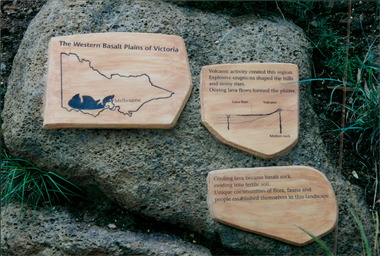
Photograph, Parkville Youth Training Centre - Plaque title "The Western Basalt Plains of Victoria"
... Department of Health and Human Services 50 Lonsdale St Melbourne melbourne Parkville Youth Training Centre - Plaque title "The Western Basalt Plains of Victoria" Photograph Photograph ... -
 Sunbury Family History and Heritage Society Inc.
Photograph, Bulla Bridge
... Many bridges in the South West of Victoria were constructed from Bluestone basalt rock because the area is on a large volcanic plain and that rock is in abundance. ...A coloured photograph of the local heritage listed bluestone bridge which spans Deep Creek at Bulla. The photograph is taken facing upstream. The bridge was constructed in 1869 and replaced a ford crossing further downstream. Many bridges in the South West of Victoria were constructed from Bluestone basalt rock because the area is on a large volcanic plain and that rock is in abundance. A non-digital coloured photograph of the Bulla Bridge which spans the Deep Creek at Bulla. Photograph 0178 is an identical photograph tO this one.bridges, bulla bridge -
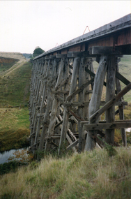 Ballarat Heritage Services
Photograph - Photograph - Colour, Clare Gervasoni, Nimon's Bridge, 1999, 04/10/1999
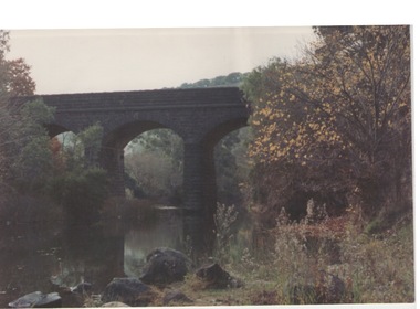
... Approached by a deep cutting and high embankment at either end, the bridge represents a very cost-effective late 19th century engineering solution to the characteristic physiography of western Victoria with flat basalt plains intersected by deep wide valleys occasionally subject to severe flooding. ...Approached by a deep cutting and high embankment at either end, the bridge represents a very cost-effective late 19th century engineering solution to the characteristic physiography of western Victoria with flat basalt plains intersected by deep wide valleys occasionally subject to severe flooding. ...Nimons Bridge was built in 1890, as part of the then Ballarat-Linton railway. The bridge is 17 spans with tall timber piers of four driven piles each, with triple sets of diagonal cross-bracing and walers and a single row of longitudinal horizontal bracing between piers. The spans are of a uniform twenty feet (6.1 metres), originally supported by four 21-inch x 9-inch (535 mm x 230 mm) Kauri timber beams per span, following the standard V.R. design of the period. When the superstructure was rebuilt after the 1953 fire, the timber beams were replaced with two 24-inch (610mm) deep rolled-steel-joists on each span. These are marked 'Lancashire Steel Co., Scotland' and are believed to have been second-hand. The deck of transverse-timber planks is 103.6 metres in length. Overall the bridge has an impressive appearance with its exceptionally tall triple-cross-braced piers creating a 'three-tiered' effect, with the deck 19.2 metres above the Woady Yaloak River. The Ballarat-Skipton line closed in 1985. Nimons Bridge has been recently restored, as part of the Ballarat-Skipton Rail Trail. How is it significant? Nimons Bridge is significant for technical, historic and aesthetic reasons at a State level. Why is it significant? Nimons Bridge is technically significant as Victoria's fourth-tallest timber trestle bridge when built, and as the third-tallest surviving example. It is also the second-largest composite bridge combining traditional timber piers with RSJ spans and a timber deck and falls within a select group of fewer than ten timber railway bridges with horizontal longitudinal bracing between the piers and three sets of double cross-bracing on its tallest piers, creating a visually striking 'three tiered' effect that enhances its viaduct form. Nimons Bridge is historically significant as having served initially the mining community at Linton, then the Western District agricultural area and in later years a kaolin quarry at Pittong. Nimons Bridge is historically significant as a representative of the 'light' branch line methodology that stimulated the explosion of railway construction in Victoria during the 1880s, and provides an interesting contrast with the more solid and vastly more expensive railway viaducts built in similar terrain on Victorian main lines, at Moorabool and Taradale, in the late 1850s. Approached by a deep cutting and high embankment at either end, the bridge represents a very cost-effective late 19th century engineering solution to the characteristic physiography of western Victoria with flat basalt plains intersected by deep wide valleys occasionally subject to severe flooding. Nimons Bridge is aesthetically significant for its visually impressive viaduct form, crossing a deep and steep-sided valley that is part of a rich cultural landscape. Within close proximity of the bridge are mullock dumps, tailings, shaft sites and other relics of the deep-lead alluvial mining era. The bridge is the most visually spectacular timber-trestle rail bridge in Western Victoria and is among the most spectacular timber-trestle rail bridges surviving anywhere in Victoria. It is part of the Ballarat-Skipton Rail Trail. Classified by the National Trust :02/10/2000 (http://vhd.heritagecouncil.vic.gov.au/places/67986)Colour photograph of a log bridge known as Nimon's Bridge.ballarat-linton, nimons bridge, nimon's bridge, log bridge, viaduct, timber-trestle rail bridge