Showing 76 items matching "basin study"
-
 Eltham District Historical Society Inc
Book, Diamond Creek Basin Study. Part 1, A Compendium of Factors Relevant to Stormwater Flows, 1980
... Diamond Creek Basin Study. Part 1, A Compendium of Factors Relevant to Stormwater Flows......basin study...Basin Studies are studies to evaluate water supply and demand and help ensure reliable water supplies by identifying strategies to address imbalances in water supply and demand....(some colour.), maps (some colour.) Diamond Creek Basin Study. Part 1, A Compendium of Factors Relevant to Stormwater Flows Book Book Melbourne Metropolitan Board of Works ...Basin Studies are studies to evaluate water supply and demand and help ensure reliable water supplies by identifying strategies to address imbalances in water supply and demand.Spiral Bound. 157 leaves in various foliations (some folded) : illustrated. (some colour.), maps (some colour.)aerial photographs, allendale road, arthurs creek mine, arthurs creek road bridge, arthurs creek, bald spur look-out, bank protection, bolton steet, bridge street bridge, bridge street, bridges, challenger street, chute street, construction, coolaroo drive, culvert, deep creek, diamond creek basin, diamond creek region, diamond creek, diamond street bridge, drainage works, eltham lower park, eltham town park, eltham trestle bridge, eltham west drains, eltham, erosion, flood management, floods, footbridge, glen katherine estate, gold mining, gum glade, hurstbridge, kangaroo ground, kinglake escarpment, kinglake national park, latiners hat factory, main road bridge, main road, masons falls, melbourne metropolitan board of works, monash bridge, mount sugarloaf, nillumbik park, orchards, railway culvert, railway line, ramptons road, real estate advertisement, research creek, st helena east drain, st helena road, st helena, storm sewers, stormwater, sugarloaf-preston transfer main crossing, susan street, union mine, village pond, water flow, watkins street, wattletree road, weidlich road, wingrove park, yarra river, zig zag road, water supply, basin study -
 Eltham District Historical Society Inc
Work on paper (Sub-Item) - Photograph, Diamond Creek in 1909
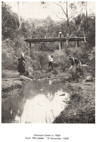
... Image printed on A4 page from 04997 Diamond Creek Basin Study, 1980...Eltham District Historical Society Inc 728 Main Rd Eltham melbourne People along the Diamond Creek, probably at Eltham with wooden bridge in background diamond creek bridge Image printed on A4 page from 04997 Diamond Creek Basin Study, 1980 Diamond Creek in 1909 Work on paper Photograph ...People along the Diamond Creek, probably at Eltham with wooden bridge in backgrounddiamond creek, bridge -
 Eltham District Historical Society Inc
Work on paper (Sub-Item) - Photograph, The Kinglake escarpment. View from Bald Spur lookout across Arthurs Creek to Mount Sugarloaf, 1980
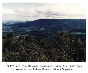
... Image printed on A4 page from 04997 Diamond Creek Basin Study, 1980...Eltham District Historical Society Inc 728 Main Rd Eltham melbourne kinglake blad spur arthurs creek mount sugarloaf Image printed on A4 page from 04997 Diamond Creek Basin Study, 1980 The Kinglake escarpment. View from Bald Spur lookout across Arthurs Creek to Mount Sugarloaf Work on paper Photograph ...kinglake, blad spur, arthurs creek, mount sugarloaf -
 Eltham District Historical Society Inc
Work on paper (Sub-Item) - Photograph, The undulating landscape at Kangaroo Ground
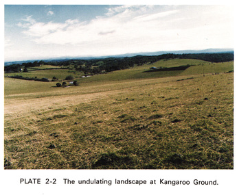
... Image printed on A4 page from 04997 Diamond Creek Basin Study, 1980...Eltham District Historical Society Inc 728 Main Rd Eltham melbourne Kangaroo Ground Image printed on A4 page from 04997 Diamond Creek Basin Study, 1980 The undulating landscape at Kangaroo Ground Work on paper Photograph ...kangaroo ground -
 Eltham District Historical Society Inc
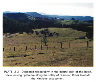
Work on paper (Sub-Item) - Photograph, Dissected topography in the central part of the Diamond Creek basin. View looking upstream along the valley of Diamond Creek towards the Kinglake escarpment
... Image printed on A4 page from 04997 Diamond Creek Basin Study, 1980...Eltham District Historical Society Inc 728 Main Rd Eltham melbourne Kinglake escarpment Image printed on A4 page from 04997 Diamond Creek Basin Study, 1980 Dissected topography in the central part of the Diamond Creek basin. ...kinglake, escarpment -
 Eltham District Historical Society Inc
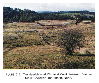
Work on paper (Sub-Item) - Photograph, The floodplain of Diamond Creek between Diamond Creek township and Eltham North
... Image printed on A4 page from 04997 Diamond Creek Basin Study, 1980...Eltham District Historical Society Inc 728 Main Rd Eltham melbourne floodplain Eltham North Image printed on A4 page from 04997 Diamond Creek Basin Study, 1980 The floodplain of Diamond Creek between Diamond Creek township and Eltham North Work on paper Photograph ...floodplain, eltham north -
 Eltham District Historical Society Inc
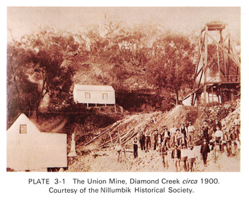
Work on paper (Sub-Item) - Photograph, The Union Mine, Diamond Creek circa 1900
... Image printed on A4 page from 04997 Diamond Creek Basin Study, 1980...Eltham District Historical Society Inc 728 Main Rd Eltham melbourne The Union Mine operated until 1916. diamond creek gold mine miners nillumbik historical society Image printed on A4 page from 04997 Diamond Creek Basin Study, 1980 The Union Mine, Diamond Creek circa 1900 Work on paper Photograph ...The Union Mine operated until 1916.diamond creek, gold mine, miners, nillumbik historical society -
 Eltham District Historical Society Inc
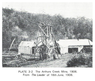
Work on paper (Sub-Item) - Photograph, The Arthurs Creek Mine, 1906
... Image printed on A4 page from 04997 Diamond Creek Basin Study, 1980...Eltham District Historical Society Inc 728 Main Rd Eltham melbourne gold mine Arthurs Creek Image printed on A4 page from 04997 Diamond Creek Basin Study, 1980 The Arthurs Creek Mine, 1906 Work on paper Photograph ...gold mine, arthurs creek -
 Eltham District Historical Society Inc
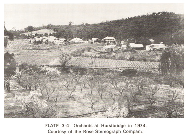
Work on paper (Sub-Item) - Photograph, Orchards at Hurstbridge, 1924
... Image printed on A4 page from 04997 Diamond Creek Basin Study, 1980...The photo was taken in 1924, the same year that Hurstbridge was declared a township. orchard hurstbridge rose postcard Image printed on A4 page from 04997 Diamond Creek Basin Study, 1980 Orchards at Hurstbridge, 1924 Work on paper Photograph ...With the extension of the railway to Hurstbridge in 1912, large commercial orchards were able to expand. By 1914, 1,886 acres of orchards were under cultivation, with a considerable proprotion of the fruit being exported overseas. After World War One, the industry declined, mainly due to competition from other areas. This photo shows an orchard in the foreground with the township of Hurstbridge in the distance. The photo was taken in 1924, the same year that Hurstbridge was declared a township. orchard, hurstbridge, rose postcard -
 Eltham District Historical Society Inc
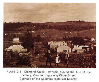
Work on paper (Sub-Item) - Photograph, View along Chute Street, Diamond Creek township, about 1901
... Image printed on A4 page from 04997 Diamond Creek Basin Study, 1980...Eltham District Historical Society Inc 728 Main Rd Eltham melbourne Diamond Creek Chute Street view Nillumbik Historical Society Image printed on A4 page from 04997 Diamond Creek Basin Study, 1980 View along Chute Street, Diamond Creek township, about 1901 Work on paper Photograph ...diamond creek, chute street, view, nillumbik historical society -
 Eltham District Historical Society Inc
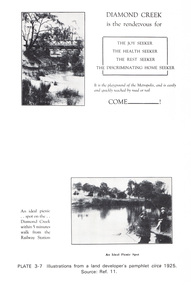
Work on paper (Sub-Item) - Photograph, Illustrations from a land developer's pamphlet promoting Diamond Creek, circa 1925
... Image printed on A4 page from 04997 Diamond Creek Basin Study, 1980...Eltham District Historical Society Inc 728 Main Rd Eltham melbourne Photos illustrating the Diamond Creek with a bridge over it and two people sitting by the creek, one is fishing with text describing the kind of person who may like to come to the township. diamond creek advertising promotion land development real estate Image printed on A4 page from 04997 Diamond Creek Basin Study, 1980 Illustrations from a land developer's pamphlet promoting Diamond Creek, circa 1925 Work on paper Photograph ...Photos illustrating the Diamond Creek with a bridge over it and two people sitting by the creek, one is fishing with text describing the kind of person who may like to come to the township. diamond creek, advertising, promotion, land development, real estate -
 Eltham District Historical Society Inc
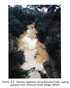
Work on paper (Sub-Item) - Photograph, Riparian vegetation along Diamond Creek. Looking upstream from Diamond Street Bridge, Eltham
... Image printed on A4 page from 04997 Diamond Creek Basin Study, 1980...Eltham District Historical Society Inc 728 Main Rd Eltham melbourne Colour photograph of a muddy creek (probably after a downpour) with plants growing on the water's edge along both banks of the creek, including trees, shrubs, grasses and vines. eltham creek vegetation diamond street bridge Diamond Creek Image printed on A4 page from 04997 Diamond Creek Basin Study, 1980 Riparian vegetation along Diamond Creek. ...Colour photograph of a muddy creek (probably after a downpour) with plants growing on the water's edge along both banks of the creek, including trees, shrubs, grasses and vines. eltham, creek, vegetation, diamond street, bridge, diamond creek -
 Eltham District Historical Society Inc
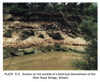
Work on paper (Sub-Item) - Photograph, Erosion on the outside of a bend just downstream of the Main Road Bridge, Eltham
... Image printed on A4 page from 04997 Diamond Creek Basin Study, 1980...Eltham District Historical Society Inc 728 Main Rd Eltham melbourne Colour photograph of a muddy Diamond Creek (probably after a downpour) with siginificant water erosion apparent at the bend of the creek in Eltham. eltham creek vegetation Diamond Creek erosion Image printed on A4 page from 04997 Diamond Creek Basin Study, 1980 Erosion on the outside of a bend just downstream of the Main Road Bridge, Eltham Work on paper Photograph ...Colour photograph of a muddy Diamond Creek (probably after a downpour) with siginificant water erosion apparent at the bend of the creek in Eltham.eltham, creek, vegetation, diamond creek, erosion -
 Eltham District Historical Society Inc
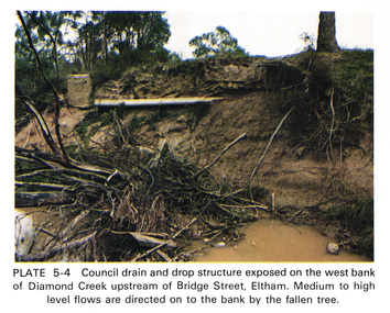
Work on paper (Sub-Item) - Photograph, Council drain and drop structure exposed on the west bank of Diamond Creek upstream of Bridge Street, Eltham
... Image printed on A4 page from 04997 Diamond Creek Basin Study, 1980...Mediun to high level water flows are directed on to the bank by the fallen tree. eltham creek diamond creek bridge street drainage waterflow vegetation Image printed on A4 page from 04997 Diamond Creek Basin Study, 1980 Council drain and drop structure exposed on the west bank of Diamond Creek upstream of Bridge Street, Eltham Work on paper Photograph ...Colour photograph of a muddy creek (probably after a downpour) showing council drain and drop structure exposed on the west bank of Diamond Creek upstream of Bridge Street, Eltham. Mediun to high level water flows are directed on to the bank by the fallen tree.eltham, creek, diamond creek, bridge street, drainage, waterflow, vegetation -
 Eltham District Historical Society Inc
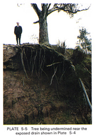
Work on paper (Sub-Item) - Photograph, Tree being undermined near an exposed drain on the west bank of Diamond Creek upstream of Bridge Street, Eltham
... Image printed on A4 page from 04997 Diamond Creek Basin Study, 1980...The tree has been undermined with roots exposed near a council drain. eltham diamond creek bridge street drainage roots tree Image printed on A4 page from 04997 Diamond Creek Basin Study, 1980 Tree being undermined near an exposed drain on the west bank of Diamond Creek upstream of Bridge Street, Eltham Work on paper Photograph ...Colour photograph of tree on the side of the Diamond Creek upstream at Bridge Street, Eltham. The tree has been undermined with roots exposed near a council drain.eltham, diamond creek, bridge street, drainage, roots, tree -
 Eltham District Historical Society Inc
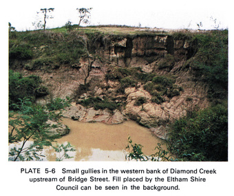
Work on paper (Sub-Item) - Photograph, Small gullies in the western bank of Diamond Creek upstream of Bridge Street, Eltham
... Image printed on A4 page from 04997 Diamond Creek Basin Study, 1980...Fill placed by the Eltham Shire Council can be seen in the background eltham diamond creek bridge street gullies fill Image printed on A4 page from 04997 Diamond Creek Basin Study, 1980 Small gullies in the western bank of Diamond Creek upstream of Bridge Street, Eltham Work on paper Photograph ...Colour photograph of a muddy creek (probably after a downpour) on the western bank of Diamond Creek upstream of Bridge Street, Eltham. Fill placed by the Eltham Shire Council can be seen in the backgroundeltham, diamond creek, bridge street, gullies, fill -
 Eltham District Historical Society Inc
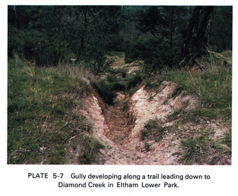
Work on paper (Sub-Item) - Photograph, Gully developing along a trail leading down to the Diamond Creek in Eltham Lower Park
... Image printed on A4 page from 04997 Diamond Creek Basin Study, 1980...Eltham District Historical Society Inc 728 Main Rd Eltham melbourne Colour photograph of a gully on a trail leading down to the Diamond Creek in Eltham Lower Park. eltham diamond creek gully Eltham Lower Park trail Image printed on A4 page from 04997 Diamond Creek Basin Study, 1980 Gully developing along a trail leading down to the Diamond Creek in Eltham Lower Park Work on paper Photograph ...Colour photograph of a gully on a trail leading down to the Diamond Creek in Eltham Lower Park. eltham, diamond creek, gully, eltham lower park, trail -
 Eltham District Historical Society Inc
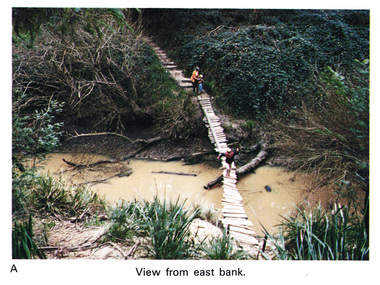
Work on paper (Sub-Item) - Photograph, Home-made footbridge across Diamond Creek, opposite Gum Glade, Eltham
... Image printed on A4 page from 04997 Diamond Creek Basin Study, 1980...View from east bank. eltham diamond creek footbridge gum glade Image printed on A4 page from 04997 Diamond Creek Basin Study, 1980 Home-made footbridge across Diamond Creek, opposite Gum Glade, Eltham Work on paper Photograph ...Colour photograph of home-made footbridge across the Diamond Creek opposite Gum Glade, Eltham. View from east bank.eltham, diamond creek, footbridge, gum glade -
 Eltham District Historical Society Inc
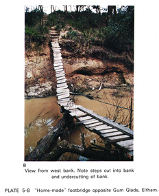
Work on paper (Sub-Item) - Photograph, Home-made footbridge across Diamond Creek, opposite Gum Glade, Eltham
... Image printed on A4 page from 04997 Diamond Creek Basin Study, 1980...Note steps cut into bank and undercutting of bank eltham diamond creek footbridge gum glade creek bank Image printed on A4 page from 04997 Diamond Creek Basin Study, 1980 Home-made footbridge across Diamond Creek, opposite Gum Glade, Eltham Work on paper Photograph ...Colour photograph of home-made footbridge across the Diamond Creek opposite Gum Glade, Eltham. View from west bank. Note steps cut into bank and undercutting of bankeltham, diamond creek, footbridge, gum glade, creek bank -
 Eltham District Historical Society Inc
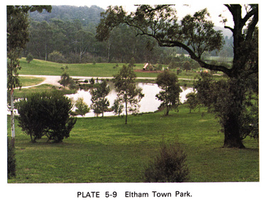
Work on paper (Sub-Item) - Photograph, Eltham Town park
... Image printed on A4 page from 04997 Diamond Creek Basin Study, 1980...This photograph was taken soon after the council reclaimed the site from a tip and before it was named for Alistair Knox. eltham diamond creek Eltham Town park Alistair Knox Park pond playground Image printed on A4 page from 04997 Diamond Creek Basin Study, 1980 Eltham Town park Work on paper Photograph ...Colour photograph of Eltham Town Park showing duck pond and children's playground in the background. This photograph was taken soon after the council reclaimed the site from a tip and before it was named for Alistair Knox. eltham, diamond creek, eltham town park, alistair knox park, pond, playground -
 Eltham District Historical Society Inc
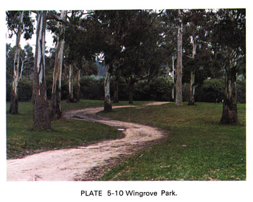
Work on paper (Sub-Item) - Photograph, Wingrove Park
... Image printed on A4 page from 04997 Diamond Creek Basin Study, 1980...Wingrove, Secretary and Engineer to the Eltham Road Board and Shire Council, 1858-1904 eltham gum trees eucalpypts walking trail Wingrove Park Image printed on A4 page from 04997 Diamond Creek Basin Study, 1980 Wingrove Park Work on paper Photograph ...Colour photograph of winding walking trail through trees at Wingrove Park. Wingrove Park in named for Eltham pioneer Charles S. Wingrove, Secretary and Engineer to the Eltham Road Board and Shire Council, 1858-1904eltham, gum trees, eucalpypts, walking trail, wingrove park -
 Eltham District Historical Society Inc
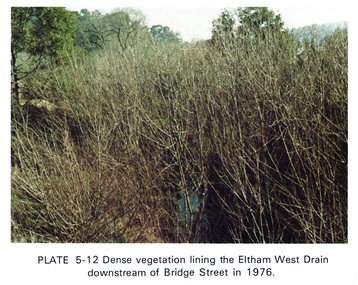
Work on paper (Sub-Item) - Photograph, Dense vegetaton lining the Eltham West Drain downstream of Bridge Street in 1976, 1976
... Image printed on A4 page from 04997 Diamond Creek Basin Study, 1980...Eltham District Historical Society Inc 728 Main Rd Eltham melbourne Colour photograph of dense vegetation lining the Eltham West drain downstream of Bridge Street, Eltham eltham vegetation weeds eltham west drain Image printed on A4 page from 04997 Diamond Creek Basin Study, 1980 Dense vegetaton lining the Eltham West Drain downstream of Bridge Street in 1976 Work on paper Photograph ...Colour photograph of dense vegetation lining the Eltham West drain downstream of Bridge Street, Elthameltham, vegetation, weeds, eltham west drain -
 Eltham District Historical Society Inc
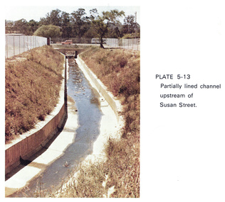
Work on paper (Sub-Item) - Photograph, Partially lined channel upstream of Susan Street
... Image printed on A4 page from 04997 Diamond Creek Basin Study, 1980...Eltham District Historical Society Inc 728 Main Rd Eltham melbourne Colour photograph of Partially lined concrete channel upstream of Susan Street, Eltham eltham Susan Street concrete channel drain Image printed on A4 page from 04997 Diamond Creek Basin Study, 1980 Partially lined channel upstream of Susan Street Work on paper Photograph ...Colour photograph of Partially lined concrete channel upstream of Susan Street, Elthameltham, susan street, concrete, channel, drain -
 Eltham District Historical Society Inc
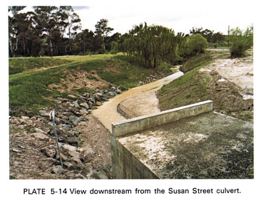
Work on paper (Sub-Item) - Photograph, View downstream from the Susan Street culvert
... Image printed on A4 page from 04997 Diamond Creek Basin Study, 1980...Eltham District Historical Society Inc 728 Main Rd Eltham melbourne Colour photograph of the view downstream from the Susan Street culvert, Eltham eltham Susan Street culvert drain channel Image printed on A4 page from 04997 Diamond Creek Basin Study, 1980 View downstream from the Susan Street culvert Work on paper Photograph ...Colour photograph of the view downstream from the Susan Street culvert, Elthameltham, susan street, culvert, drain, channel -
 Eltham District Historical Society Inc
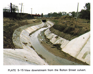
Work on paper (Sub-Item) - Photograph, View downstream from the Bolton Street culvert
... Image printed on A4 page from 04997 Diamond Creek Basin Study, 1980...Eltham District Historical Society Inc 728 Main Rd Eltham melbourne Colour photograph of the view downstream from the Bolton Street culvert, Eltham eltham channel concrete drain Bolton Street Image printed on A4 page from 04997 Diamond Creek Basin Study, 1980 View downstream from the Bolton Street culvert Work on paper Photograph ...Colour photograph of the view downstream from the Bolton Street culvert, Elthameltham, channel, concrete, drain, bolton street -
 Eltham District Historical Society Inc
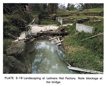
Work on paper (Sub-Item) - Photograph, Landscaping at Latiners Hat Factory
... Image printed on A4 page from 04997 Diamond Creek Basin Study, 1980...Note blockage at the bridge eltham drain Latiners Hat factory landscaping footbridge blockage Image printed on A4 page from 04997 Diamond Creek Basin Study, 1980 Landscaping at Latiners Hat Factory Work on paper Photograph ...Colour photograph of Landscaping at Latiners Hat Factory, Sherbourne Road, Eltham. Note blockage at the bridgeeltham, drain, latiners, hat factory, landscaping, footbridge, blockage -
 Eltham District Historical Society Inc
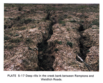
Work on paper (Sub-Item) - Photograph, Deep rills in the creek bank between Rampstons and Weidlich Roads
... Image printed on A4 page from 04997 Diamond Creek Basin Study, 1980...The shallow channels are cut into the soil by the erosive action of flowing water. eltham creek bank erosion eltham north Image printed on A4 page from 04997 Diamond Creek Basin Study, 1980 Deep rills in the creek bank between Rampstons and Weidlich Roads Work on paper Photograph ...Colour photograph of deep rills in the Diamond Creek bank between Rampstons and Weidlich Roads, Eltham North. The shallow channels are cut into the soil by the erosive action of flowing water.eltham, creek bank, erosion, eltham north -
 Eltham District Historical Society Inc
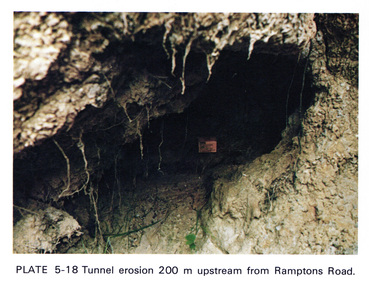
Work on paper (Sub-Item) - Photograph, Tunnel erosion 220 m upstream from Ramptons Road
... Image printed on A4 page from 04997 Diamond Creek Basin Study, 1980...Eltham District Historical Society Inc 728 Main Rd Eltham melbourne Colour photograph of tunnel erosion 220 metres upstream from Ramptons Road, Eltham North eltham erosion eltham north drain Image printed on A4 page from 04997 Diamond Creek Basin Study, 1980 Tunnel erosion 220 m upstream from Ramptons Road Work on paper Photograph ...Colour photograph of tunnel erosion 220 metres upstream from Ramptons Road, Eltham North eltham, erosion, eltham north, drain -
 Eltham District Historical Society Inc
Work on paper (Sub-Item) - Photograph, St Helena East drain immediately downstream of St Helena Road
... Image printed on A4 page from 04997 Diamond Creek Basin Study, 1980...The house shown is one of the first to be built on the Glen Katherine Estate. eltham drain St Helena Glen Katherine Estate Greensborough Image printed on A4 page from 04997 Diamond Creek Basin Study, 1980 St Helena East drain immediately downstream of St Helena Road Work on paper Photograph ...Colour photograph of St Helena East drain immediately downstream of St Helena Road, Greensborough. The house shown is one of the first to be built on the Glen Katherine Estate.eltham, drain, st helena, glen katherine estate, greensborough -
 Eltham District Historical Society Inc
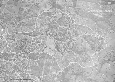
Work on paper (Sub-Item) - Photograph, Research Creek
... Image printed on A4 page from 04997 Diamond Creek Basin Study, 1980...Eltham District Historical Society Inc 728 Main Rd Eltham melbourne Black and White aerial photograph of Research witht the Research Creek and Main Road highlighted. eltham research aerial view Research Creek Image printed on A4 page from 04997 Diamond Creek Basin Study, 1980 Research Creek Work on paper Photograph ...Black and White aerial photograph of Research witht the Research Creek and Main Road highlighted.eltham, research, aerial view, research creek