
Showing 20 items matching "bathing house"
-
 St Kilda Historical Society
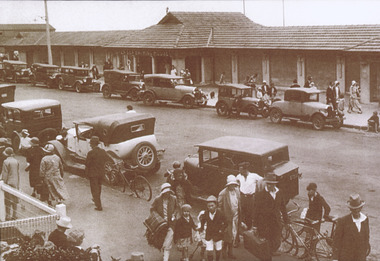
Photograph - Building, Open Beach Bathing House
... Open Beach Bathing House...black and white photograph copy mounted Open Beach Bathing House Photograph Building ...black and white photograph copy mounted -
 Northern District School of Nursing. Managed by Bendigo Historical Society Inc.
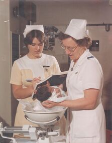
Photograph - Stanistreet House - Bathing Newborn
... Stanistreet House - Bathing Newborn...NDNS Nursing Training Nursing Education Equipment BBH Stanistreet House Nr J Priest Sr v Doble - Aulsebrook & Martin Photographers 311 Williamson Street Bendigo Ph 43 5626 Sister Valda Doble and Nurse Julie Priest - Bathing Newborn Photograph Stanistreet House - Bathing Newborn ...The Northern District School of Nursing opened in 1950 in to address the issues around nurse recruitment, training and education that had previously been hospital based. The residential school was to provide theoretical and in-house education and practical training over three years. The students would also receive practical hands-on training in the wards of associated hospitals. The Northern District School of Nursing operated from Lister House, Rowan Street, Bendigo. It was the first independent school of nursing in Victoria and continued until it closed in 1989.Sister Valda Doble and Nurse Julie Priest - Bathing Newborn BBH Stanistreet House Nr J Priest Sr v Doble - Aulsebrook & Martin Photographers 311 Williamson Street Bendigo Ph 43 5626ndns, nursing training, nursing education equipment -
 Federation University Historical Collection
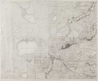
Map, Ballaarat Gold Field, 1861, 1861
... ...Bathing House...In November 2004 the Central Highlands Regional Library presented a special edition of 200 copies of the 1861 map reproduced from a copy in their collection. ballarat map ballarat east lake wendouree survey mines robert davidson ballarat gold field 1861 yuille's swamp wendouree swamp little bendigo diggings gold leads old post office hill specimen hill bakery hill black hill dead horse creek brown hill pennyweight hill clayton hill soldiers hill golden point gum tree flat white flat poverty hill chinese village robert brough smyth Ballarat map 1861 Ballaarat Vineyard Dead Horse Gully Deadhorse Creek Invermay Black Hill Flat Gaelic Church Police Reserve Magpie Range Dalton's Flat Caadian Lead Rifle Butts Powder Magazine Bathing House Government Camp Gold Office Chinese Llanberrris Victoria Theatre Charlie Napier Hotel United States Hotel Grape's Hoel Clayton's Hill Cattleyard Hill Free Trade Hotel Esmond Lead Bakery Hill Black Hill Lead Juvenile Reformatory Ballarat Orphanage Lady Barkly Lead Triffet's Slaughter Yard Little Bendigo Melbourne Road T. ...A party of surveyors camped by Yuille's Swamp (later Lake Wendouree) and surveyed the countryside for a map to be produced by the Geological Survey of Victoria. In November 2004 the Central Highlands Regional Library presented a special edition of 200 copies of the 1861 map reproduced from a copy in their collection. Original 1861 map of Ballarat showing streets and leads. Blue dots indicate gold leads, and red lines indicate auriferous quartz reef and outcrops of quartz veins."Compiled & Drawn from the Survey of Mining Surveyors Davidson, Fitzpatrick and Cowan & the Plans in the Surveyor General's Office by J. Brahe, 21st October 1861. R. Brough Smyth, Secretary for Mines. The Honourable J.B. Humffray, M.L.A. Commr of Mines.”ballarat, map, ballarat east, lake wendouree, survey, mines, robert davidson, ballarat gold field 1861, yuille's swamp, wendouree swamp, little bendigo diggings, gold leads, old post office hill, specimen hill, bakery hill, black hill, dead horse creek, brown hill, pennyweight hill, clayton hill, soldiers hill, golden point, gum tree flat, white flat, poverty hill, chinese village, robert brough smyth, ballarat map 1861, ballaarat vineyard, dead horse gully, deadhorse creek, invermay, black hill flat, gaelic church, police reserve, magpie range, dalton's flat, caadian lead, rifle butts, powder magazine, bathing house, government camp, gold office, chinese, llanberrris, victoria theatre, charlie napier hotel, united states hotel, grape's hoel, clayton's hill, cattleyard hill, free trade hotel, esmond lead, bakery hill, black hill lead, juvenile reformatory, ballarat orphanage, lady barkly lead, triffet's slaughter yard, little bendigo, melbourne road, t. cowan, thomas cowan -
 Lakes Entrance Historical Society
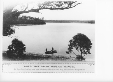
Photograph - Karpi Bay Lake Tyers, Caire, Nicholas John, c1905
... The Nowa Nowa Arm runs to the left of the bathing-house on the other shore, where we find Lake Tyers House....The Nowa Nowa Arm runs to the left of the bathing-house on the other shore, where we find Lake Tyers House. ...Karpi Bay from Mission Garden. The Nowa Nowa Arm runs to the left of the bathing-house on the other shore, where we find Lake Tyers House.Black and white photograph of Karpi Bay, Lake Tyers showing two men in an open boat in the foreground of a wide expanse of water. A large tree branch overhanging along the top of the picture, which is taken from a high vantage point. Lake Tyers VictoriaKarpi Bay from the Lake Tyers Mission gardenwaterways, boats and boating, aboriginals -
 Vision Australia
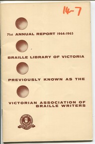
Administrative record - Text, 71st annual report 1964 - 1965 Braille Library of Victoria, 1965
... Articles include the production of Christmas cards for purchase, the departure of Mr Davey as treasurer due to commitments in his personal life and that his property was completely burned out by bushfires and would be far more attention, catering difficulties at the Christmas party required improved facilities in the kitchen and this, as well as changes to seating and emergency exit changes due to meet building inspection, has seen an increase in bookings for the Hall, bathing box house at Chelsea still in good repair, two successful Braille Reading competitions held, J. ...Articles include the production of Christmas cards for purchase, the departure of Mr Davey as treasurer due to commitments in his personal life and that his property was completely burned out by bushfires and would be far more attention, catering difficulties at the Christmas party required improved facilities in the kitchen and this, as well as changes to seating and emergency exit changes due to meet building inspection, has seen an increase in bookings for the Hall, bathing box house at Chelsea still in good repair, two successful Braille Reading competitions held, J. ...Articles include the production of Christmas cards for purchase, the departure of Mr Davey as treasurer due to commitments in his personal life and that his property was completely burned out by bushfires and would be far more attention, catering difficulties at the Christmas party required improved facilities in the kitchen and this, as well as changes to seating and emergency exit changes due to meet building inspection, has seen an increase in bookings for the Hall, bathing box house at Chelsea still in good repair, two successful Braille Reading competitions held, J. Williams - a transcriber- visited American and returned home with a Perkins Brailler as she uses for the library and provided another one to the library, and although no response has been forthcoming from the Free Library Service Board of Victoria, the government inquiry into the Victorian Library Service has recommended that financial support be given to the Braille Library of Victoria.32 pages of text with drawingsbraille library of victoria, annual report -
 Federation University Historical Collection
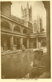
Postcard - Postcard - Sepia, Bath, Roman Baths and Abbey
... The house is a well-preserved Roman site for public bathing. The Roman Baths themselves are below the modern street level. ...The house is a well-preserved Roman site for public bathing. The Roman Baths themselves are below the modern street level. ...The Roman Baths complex is a site of historical interest in the English city of Bath. The house is a well-preserved Roman site for public bathing. The Roman Baths themselves are below the modern street level. There are four main features: the Sacred Spring, the Roman Temple, the Roman Bath House and the Museum, holding finds from Roman Bath. The buildings above street level date from the 19th century. Three sepia postcards with a photographic impressions of the Roman Baths, Abbey, and Grand Pump Room, Bath. All postcards unwritten..3) Bath. Roman Baths and Abbey. Within the distance of a few yards are the Roman Baths, built about A. D. 55 ; the Abbey, erected in 1499 : the King's Bath of 17th and 18th century construction, and the modern Bathing establishment containing the latest scientific appliances for the administration of the radio-active waters for the cure and relief of many complaints.bath, roman baths, roman, archeaology -
 Federation University Historical Collection
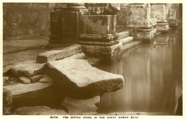
Postcard - Sepia, The Diving Stone in the Great Roman Bath, Bath, Somerset
... bathing, and it has steps leading down on all sides. Niches around the baths would have held benches for bathers and possibly small tables for drinks or snacks. A large flat slab of stone is set across the point where hot water flows into the bath. It is known today as the diving stone. The Roman Baths complex is a site of historical interest in the English city of Bath. The house...bathing, and it has steps leading down on all sides. Niches around the baths would have held benches for bathers and possibly small tables for drinks or snacks. A large flat slab of stone is set across the point where hot water flows into the bath. It is known today as the diving stone. The Roman Baths complex is a site of historical interest in the English city of Bath. The house ...The Great Bath is a massive pool, lined with 45 sheets of lead, and filled with hot spa water. It once stood in an enormous barrel-vaulted hall that rose to a height of 40 metres. For many Roman visitors this may have been the largest building they had ever entered in their life. The bath is 1.6 metres deep, which was ideal for bathing, and it has steps leading down on all sides. Niches around the baths would have held benches for bathers and possibly small tables for drinks or snacks. A large flat slab of stone is set across the point where hot water flows into the bath. It is known today as the diving stone. The Roman Baths complex is a site of historical interest in the English city of Bath. The house is a well-preserved Roman site for public bathing. The Roman Baths themselves are below the modern street level. There are four main features: the Sacred Spring, the Roman Temple, the Roman Bath House and the Museum, holding finds from Roman Bath. The buildings above street level date from the 19th century. Sepia postcard of a section of the Great Roman Bath at Bath, Somerset featuring the Diving Stone.printed verso: The Diving Stone in the great roman bath. The Diving stone, at the north-west corner of the great Roman Bath, still shows where the feet of bygone bathers wore away its surface. The hot mineral waters flowed into the bath through a channel under this stone. chatham-holmes family collection, bath, great roman bath, swimming pool -
 Federation University Historical Collection
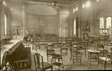
Postcard - black and white, Bath Pump Room (interior), c1917
... The house is a well-preserved Roman site for public bathing. The Roman Baths themselves are below the modern street level. ...The house is a well-preserved Roman site for public bathing. The Roman Baths themselves are below the modern street level. ...WW1 Holmes Family souvenir. Bath is famous for its mineral water bath. The Roman Baths complex is a site of historical interest in the English city of Bath. The house is a well-preserved Roman site for public bathing. The Roman Baths themselves are below the modern street level. There are four main features: the Sacred Spring, the Roman Temple, the Roman Bath House and the Museum, holding finds from Roman Bath. The buildings above street level date from the 19th century. WW1 Australian Soldier's memorabiliaBlack and white postcard showing a number of chairs and tables in the Pump House at Bath, England.bath, pump house, chatham-holmes family collection, world war 1, postcard -
 Federation University Historical Collection
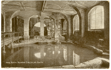
Photograph - Black and White, The Photochrome Co. Ltd, Bath
... The house is a well-preserved Roman site for public bathing. The Roman Baths themselves are below the modern street level. ...The house is a well-preserved Roman site for public bathing. The Roman Baths themselves are below the modern street level. ...The Roman Baths complex is a site of historical interest in the English city of Bath. The house is a well-preserved Roman site for public bathing. The Roman Baths themselves are below the modern street level. There are four main features: the Sacred Spring, the Roman Temple, the Roman Bath House and the Museum, holding finds from Roman Bath. The buildings above street level date from the 19th century. . Two black and white postcards of views of Bath. .1) Roman Circular Bath .2) Empire Hotel and Bridge, Bathchatham family archive, roman, bath -
 Flagstaff Hill Maritime Museum and Village
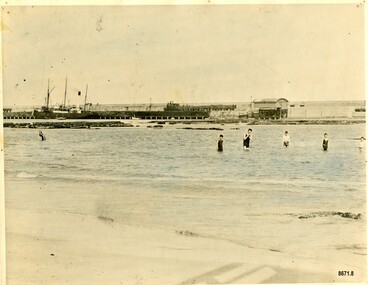
Photograph - Vessel S. S. Casino in Lady Bay Warrnambool, 1920's - 1930's
... Bathing...Swimming...Warrnambool Beach...Beach Improvement Fund...Port of Warrnambool...Steamships...Lifeboat House...Warrnambool Great Ocean Road Shipwreck Coast Lady Bay Breakwater Fred Trewartha Frederick John Fox Trewartha Surf Bathers Association Sea Bathing Swimming Warrnambool Beach Beach Improvement Fund Port of Warrnambool Steamships Lifeboat House Rocket House Lifeboat Crew S. ...This photograph was one of ten photographs donated to Flagstaff Hill Maritime Museum and Village by Fred Trewartha. Frederick John Fox Trewartha (Fred) was a well-known Warrnambool businessman. He was born in Beeac near Geelong in 1920 and came to Warrnambool with his family as a very young child. He was apprenticed to his father John, as a saddler and later opened his own shop on Raglan Parade. He then moved into working with tarpaulins and canvases for the trucking industry. Fred was keenly interested in photography (and was a member of the Warrnambool Cine Club), yachting and boat building. He kept his yacht moored at Port Fairy for many years and participated in sailing events locally and interstate. He also built boats with his sons. He had the opportunity to meet many older sailors and it's thought this photo (and others in the set) may have been given to him by one of these men. Fred Trewartha died in 2016 in Warrnambool. Warrnambool by the 1920's and 1930's had become a popular holiday destination with visitors arriving by steamer and train. It was during these decades that a "Surf Bathers Association" began in Warrnambool in response to the growing popularity of local sea bathing. They worked with the local council to develop a "Beach Improvement Fund" and a comprehensive plan of "Beach Improvement" which included erecting and maintaining beach boxes, building a kiosk, improving paths and roads to the beach, planting marram grass on the sand dunes, building new enclosures for vehicles and horses and generally making the beach more attractive for visitors and townspeople. The 1930's was also an era when free "Herald" Learn-to-Swim classes were being held throughout Victoria. In 1931 it was reported in "The Age" newspaper that "over the past week in Warrnambool, 250 pupils had passed through the hands of the local life saving club swimming instructors". The Port of Warrnambool - In the early years the Port of Warrnambool was a busy port. Steamships and sailing ships were frequent visitors to the port. Steam navigation companies were plentiful, carrying passengers and freighting cargo such as coal, timber, food, livestock, furniture, hardware and haberdashery between Melbourne and the ports along the southwest coast of Victoria, including Warrnambool. The carts would take their loads into the township for distribution. The Breakwater was built (using 32 ton blocks of concrete) between 1874 and 1890 to provide ships with greater protection from the Southern Ocean. The Lifeboat and Rocket House - The coastline of South West Victoria has had over 600 shipwrecks and many lost lives; even in Warrnambool’s Lady Bay there were around 16 known shipwrecks between 1850 and 1905, with eight lives lost. In 1859 the first Government-built lifeboat arrived at Warrnambool Harbour and a shed was soon built to house it, followed in 1864 by a rocket house to safely store the Rocket Rescue equipment. In 1878 the buildings were moved to the Breakwater area, and in 1910 the new Lifeboat Warrnambool arrived with its ‘self-righting’ design. For almost one hundred years the lifeboat and rocket crews, mostly local volunteers, trained regularly to maintain and improve their skills, summoned when needed by alarms, gunshots, ringing bells and foghorns. Some became local heroes but all served an important role. By the end of the 1950s the lifeboat and rescue equipment had become obsolete. The S.S. Casino was a passenger and freight steamer built in Dundee, Scotland, in 1882 for the Newcastle and Hunter River Steam Navigation Company of N.S.W. She weighed 425 tons gross with a length of 160.4 feet, beam of 24.1 feet and a depth of 10.2 feet. She had saloon accommodation for 35 people, a fore cabin for 25 more people, and she carried 300 tons of cargo. While on her delivery journey on May 30th 1882, the S.S. Casino called in at the Port of Warrnambool for coal, narrowly escaping going ashore in gale force winds due to the quick action of the pilot. At that time, still at anchor, she impressed the directors of the Belfast and Koroit Steam Navigation Company so much that they bought her immediately; she was ideal for trade along the West Coast of Victoria. (The Belfast and Koroit Steam Navigation Company was first managed by Messers. Saltau and Osburne and after the passing of Mr. Osburne, by produce merchants Messers H. Sautau and Sons, who had a hay and corn store and shipping agency on the corner of Liebig and Koroit Streets in Warrnambool. ) The S.S. Casino became “the most famous steamer to operate in Victorian waters along the West Coast” by author Jack Loney. Captain Boyd was her first Master, followed by Captain Chapman, who stayed with her from 1890 until 1924. Captain W. Robertson followed for a short term, and then Captain Middleton then took command from 1925 - 1932. An article published on Monday 11th June 1932 in The Sun News Pictorial (Melbourne) giving a detailed history of S. S. Casino said "owned by Port Fairy interests, she was an integral part of the town's development ... for a long time, her arrival in Port Fairy was an event, the townspeople going down to the wharf to see her come in". It also said "Except when the weather was bad, the Casino hugged the coast on her trips and passengers obtained wonderful views of the sandstone terraces and caves. A little time ago every member of her regular crew except one, was a Scotsman." The S.S. Casino had several mishaps during her life. One was on 3rd January 1898 when she collided with the S.S. Flinders in Apollo Bay with minor damage. Another was on 24th October 1924 when she grounded on a reef at Point Hawdon near Grey River and most of her cargo (of Christmas goods) had to be dumped into the sea. Then in February 1929 she was ‘holed’ when she struck a submerged object as she entered Lady Bay, Warrnambool. In the years following the turn of the century, the S.S. Casino remained the only regular trader with normal passenger accommodation along the West Coast. From 1882 she had made at least 2,500 voyages on the one run. On the morning of 10th July 1932, after attempting to berth at Apollo Bay jetty in heavy seas, Captain Middleton decided to take her out into the bay and wait until the seas abated. It was not realised that the anchor used to steady her as she manoeuvred to her berth had pierced her hull. She put about and headed for the beach but sank. Captain Middleton and nine others lost their lives; nine people were rescued including the two female passengers. Captain Middleton had been in charge of the S.S. Casino for seven years. He was the first ship’s Master to lose his life in a shipwreck in the West Coast trade. In June 1932, the directors of the Belfast and Koroit Steam Navigation Company had proposed to celebrate the completion of fifty years of trading by the steamer Casino in August, but tragically the Casino was wrecked only one month later (and "was only one month off completing its fifty years of valuable service between Melbourne and Portland.") Flagstaff Hill’s collection has a photograph of a portrait of Captain Chapman, a ship model of the S.S. Casino that shows both forms of power under which she sailed, steam and sail. The ship is painted green and flies three flags. The inscription across the case of the ship model, incorrectly dated, tells the sad story of the wreck of the ship and the loss of lives on July 10th 1932 at Apollo Bay. A print in the Collection shows S.S. Casino underway in the heavy sea off Point Lonsdale, another two photographs show her at the Port of Warrnambool, leaving from the Breakwater in Lady Bay and another identifies the S.S. Casino as a ship from the Belfast and Koroit Steam Navigation Company. (Belfast is the original name for the township of Port Fairy).This photograph is significant because of its association with the coastal trader S.S. Casino and its significance to trade along Victoria's West Coast in the late 19th and early 20th centuries. The wreck of the S.S. Casino is considered an important part of Victorian and Australian cultural heritage and as such has been declared and protected as an Historic Shipwreck under State and Commonwealth Law in the Commonwealth Historic Shipwrecks Act (1976). It is also significant as it shows the early years of tourism in Warrnambool and the important role the beach played in the lives of residents and visitors.A black and white photograph (with colour tinting) showing Lady Bay in Warrnambool with the Breakwater in the background. The S. S. Casino is moored at the Breakwater and the lifeboat shed and a coal train can be seen on the Breakwater. Six swimmers are standing in the water. On the back of the photograph are the donor's name and telephone number (written in black biro) and the name of the S. S. Casino and its tonnage written in blue ink. A blurred number has been stamped on plus a "M' written in pencil.Donor's name, address and phone number / "S. S. Casino" / "500 TONS" / "REG" "- - - 09 " (blurred numbers) / "M"warrnambool, great ocean road, shipwreck coast, lady bay, breakwater, fred trewartha, frederick john fox trewartha, surf bathers association, sea bathing, swimming, warrnambool beach, beach improvement fund, port of warrnambool, steamships, lifeboat house, rocket house, lifeboat crew, s. s. casino, belfast and koroit steam navigation company, saltau and osburne, captain middleton, apollo bay, apollo bay shipwreck -
 Glenelg Shire Council Cultural Collection
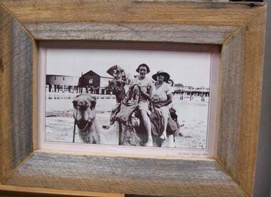
Photograph - Photograph Print - reproductive, Portland, Victoria, 1930, c. 1933
... House. Front: Portland, Victoria 1930 (printed, lower left). Back: c1933, Abdul and his Camels (blue pen, upper left). Lady with hat - Mrs. Andrews - (ME) Mrs Ernest (Myrtle) (blue pen, top centre). Photograph depicting 2 women riding a camel. Two other camels in background. In background is piers and bathing ...On display in History House.Photograph depicting 2 women riding a camel. Two other camels in background. In background is piers and bathing pavilion.Front: Portland, Victoria 1930 (printed, lower left). Back: c1933, Abdul and his Camels (blue pen, upper left). Lady with hat - Mrs. Andrews - (ME) Mrs Ernest (Myrtle) (blue pen, top centre). -
 Orbost & District Historical Society
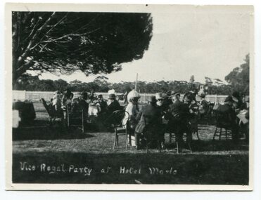
black and white photograph, late 19th century / early 20th century
... House" became "The Marlo Hotel". The Marlo Hotel was popular with many Orbost and district settlers, who travelled to Marlo by horseback or buggy. In the early 20th century the hotel advertised itself as " Under Vice-Regal Patronage. Situated on High Cliff, fronting Ocean, Lakes and Snowy River. Those in search of Health, Rest and Sport should visit Marlo. Boating, Fishing, Shooting, Bathing...House" became "The Marlo Hotel". The Marlo Hotel was popular with many Orbost and district settlers, who travelled to Marlo by horseback or buggy. In the early 20th century the hotel advertised itself as " Under Vice-Regal Patronage. Situated on High Cliff, fronting Ocean, Lakes and Snowy River. Those in search of Health, Rest and Sport should visit Marlo. Boating, Fishing, Shooting, Bathing ...The first settler to occupy the Marlo township area was James Stirling around the year 1875. He built a bark hut on the bluff that had two rooms, bark walls, earthen floors and a shingle roof. By 1884, this structure had expanded to a 9 roomed accommodation house and in 1886 became the Marlo Hotel when a liquor license was granted. The Governor-in-Council declared Marlo to be a township on 18 February 1889. During May 1889, the government surveyor, E.L. Bruce set out 19 sections of the new township, with the first sales of subdivided land occurring the following May. At this time, Stirling's Marlo Hotel was the unofficial hub for the community. It was a general store, accommodation house and the unofficial post office, with settlers taking turns in bringing the mail from Orbost or Cunningham. This continued until Aug 1942, and in 1969 was located in a house adjacent to the Marlo Hotel, before being transferred to the Marlo General Store in this year. The official Post Office List states the Marlo Post Office opened around 1902. in 1925, the "Marlo House" (a nine room accommodation guest house) was granted a liquor licence. The "Marlo House" became "The Marlo Hotel". The Marlo Hotel was popular with many Orbost and district settlers, who travelled to Marlo by horseback or buggy. In the early 20th century the hotel advertised itself as " Under Vice-Regal Patronage. Situated on High Cliff, fronting Ocean, Lakes and Snowy River. Those in search of Health, Rest and Sport should visit Marlo. Boating, Fishing, Shooting, Bathing, Golf. Comfort and Convenience at Marlo Hotel, near Orbost, East Gippsland. Nixon's Cars would meet the train at at Orbost. Fare---6s single, 12s return. Telephone No. 1, Marlo. S, P, STEWART, Proprietor." The Marlo Hotel, perched on the hill overlooking the estuaries and the entrance is a significant building in Marlo. Established in 1886, it has been operating for over 120 yearsAn original black / white photograph and a black / white copy of a party being held under trees on the lawn of the Marlo Hotel. It is a postcard with advertising of Marlo on the back.on back - "Where to spend your holiday - Marlo" on front - "Vice Regal Party at Hotel, Marlo"marlo-hotel -
 Bendigo Military Museum
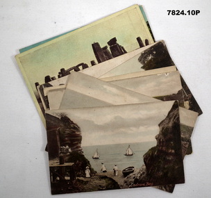
Postcard - POSTCARDS, PHOTOGRAPHIC, VARIOUS U.K, c. WW1
... bathing machines, cliffs and town buildings. 4. Coloured coastal scene featuring beach with boats and town buildings. 5. Sepia toned photograph featuring houses...bathing machines, cliffs and town buildings. 4. Coloured coastal scene featuring beach with boats and town buildings. 5. Sepia toned photograph featuring houses ...Postcards collected by R.H. Baron while on leave in England during WW1. Part of the "Robert H. Baron" (No. 3596) and Cooper Collections. See Catalogue No. 1981P for details of Baron's service. 1. Coloured coastal scene featuring yachts, beach goers and cliffs. People are standing on a pebbled beach. 2. Coloured coastal scene featuring cliffs and ocean. 3. Coloured coastal scene featuring beach, bathing machines, cliffs and town buildings. 4. Coloured coastal scene featuring beach with boats and town buildings. 5. Sepia toned photograph featuring houses. Stream running in front of house. Footpath between stream and house. 6. Coloured street scene featuring houses fronting a gravel road. 7. Black and white photograph of a street scene featuring buildings, pedestrians and horse drawn transport. 8. Sepia toned photograph of a street scene. Right side lined with houses. Single pedestrian on footpath. 9. Coloured scene featuring standing stones. 10. Coloured photograph of a ruined building overgrown with vegetation.1. Ladram Bay. 2. Ladram Bay. 3. Budleigh Salterton from East. 4. Budleigh Salterton from West. 5. Budleigh Salterton, Cottages at the Granery, 6. Budleigh Salterton, West Terrace. 7. High St. Budleigh Salterton. 8. Budleigh Salterton, Station Road. 9. Stonehenge. 10. Abbey Ruins, Waverley. robert h. baron, cooper collection, postcards, ww1 -
 Warrnambool and District Historical Society Inc.
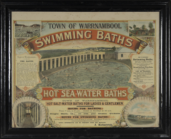
Photograph - Framed photograph of Warrnambool Salt Water Baths, c. 1920
... The men's pool was 100 feet by 50 feet and the women's pool was 60 feet by 30 feet with bathing strictly segregated in the 19th century. A building nearby housed marble cubicles with hot spa baths with the water heated on the site and a caretaker's cottage completed the complex. ...The men's pool was 100 feet by 50 feet and the women's pool was 60 feet by 30 feet with bathing strictly segregated in the 19th century. A building nearby housed marble cubicles with hot spa baths with the water heated on the site and a caretaker's cottage completed the complex. ...This is a framed photograph of the men's pool at the Warrnambool Salt Water Baths. These Baths were originally built at the end of Gilles Street on the line of the present railway line in 1876 but were rebuilt in 1889 further north in Gilles Street when the railway line was opened. The water was pumped from the sea, initially by a windmill and later by a gas pump. The men's pool was 100 feet by 50 feet and the women's pool was 60 feet by 30 feet with bathing strictly segregated in the 19th century. A building nearby housed marble cubicles with hot spa baths with the water heated on the site and a caretaker's cottage completed the complex. Men's nude bathing was a feature of the early 20th century. Originally built by a local public company the Baths were taken over by the Warrnambool Council. These baths were superseded by the opening in 1961 of an Olympic Pool In Warrnambool. The site and the remaining buildings of the old sea water baths are now heritage-listed and today form part of the headquarters of the Warrnambool and District Historical Society.This photograph is of historical significance as a depiction of the Warrnambool Salt water Baths in the early 20th century. These Baths were the basis for promoting Warrnambool as a health and spa resort town in the late 19th and early 20th centuries.This is a framed black and white photograph of the men's pool at the Warrnambool Salt Water Baths. It depicts men and boys swimming in the circular pool and one male on the diving board. All these men are naked. There are other clothed males and clothed attendants wearing hats and waistcoats. The change rooms are on the right side of the photograph and there is a fence with trees behind. The photograph is mounted on cardboard with a gilt edge and is held in a wooden ridged frame behind glass. warrnambool sea water baths, sea baths, warrnambool pool, gilles street -
 Lakes Entrance Historical Society
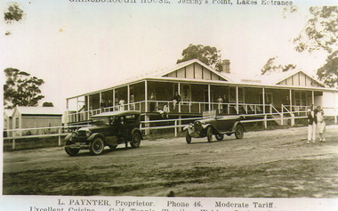
Photograph - Gainsborough House, Jemmy's Point, Lakes Entrance c1925
... Gainsborough House Jemmys Point Lakes Entrance.L Paynter, Proprietor, Phone 46, Moderate Tariff. Excellent Cuisine, Golf, Tennis, Shooting, Fishing, Surfing, Bathing....Guesthouses Transport People Gainsborough House Jemmys Point Lakes Entrance.L Paynter, Proprietor, Phone 46, Moderate Tariff. Excellent Cuisine, Golf, Tennis, Shooting, Fishing, Surfing, Bathing. ...Gainsborough House was built of boxed poured concrete by Leslie Paynter and his father William Henry Paynter. It was opened about Christmas 1923 or 1924.Black and white photograph of Gainsborough House, Jemmy's Point, showing an attractive accommodation house with veranda on front and north side. It is of concrete construction with iron roof. Guests on veranda and couple standing on road. Two soft top motor cars parked on road. Lakes Entrance VictoriaGainsborough House Jemmys Point Lakes Entrance.L Paynter, Proprietor, Phone 46, Moderate Tariff. Excellent Cuisine, Golf, Tennis, Shooting, Fishing, Surfing, Bathing.guesthouses, transport, people -
 Lakes Entrance Historical Society
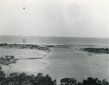
Photograph - The Entrance Lakes Entrance Victoria c1924
... Black and white photograph showing view from Jemmys Point of the entrance, with wooden piers, PWD houses and works buildings at New Works. West end of Bullock Island on left side of photo, bathing boxes and some trees on island, some rock groyne work at the entrance. ...Piers Islands Houses Black and white photograph showing view from Jemmys Point of the entrance, with wooden piers, PWD houses and works buildings at New Works. West end of Bullock Island on left side of photo, bathing boxes and some trees on island, some rock groyne work at the entrance. ...Black and white photograph showing view from Jemmys Point of the entrance, with wooden piers, PWD houses and works buildings at New Works. West end of Bullock Island on left side of photo, bathing boxes and some trees on island, some rock groyne work at the entrance. piers, islands, houses -
 Surrey Hills Historical Society Collection
Photograph, Palstra children at the beach, c 1930, 1930
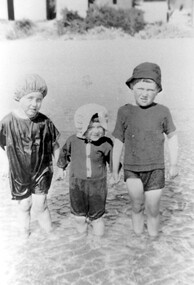
... The house remains in 2009 with extensions to the rear and side. sports and recreations swimming clothing and dress bathing costumes william palstra margaret palstra jocelyn palstra margaret thornton Black and white photo of Margaret, Jocelyn and William Palstra wading in the shallows at an unidentified beach; bathing boxes in the background. ...Date is approximate. Donor, Margaret Thornton was a daughter of William and May Palstra; one of her daughters, Julia Thornton still lives in the house in 2024. Donation form signed by Julia Thornton. The house remains in 2009 with extensions to the rear and side.Black and white photo of Margaret, Jocelyn and William Palstra wading in the shallows at an unidentified beach; bathing boxes in the background. sports and recreations, swimming, clothing and dress, bathing costumes, william palstra, margaret palstra, jocelyn palstra, margaret thornton -
 University of Melbourne, Burnley Campus Archives
Photograph - Black and white print, Port Phillip Bay Beach, Unknown
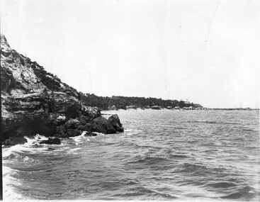
... Rocky promontory with beach further on - bathing boxes seen in B91.427, houses and jetty on next point....Rocky promontory with beach further on - bathing boxes seen in B91.427, houses and jetty on next point. ...Black and white photograph. Port Phillip Bay beach, excursion. Rocky promontory with beach further on - bathing boxes seen in B91.427, houses and jetty on next point.port phillip bay beach, excursion, rocks -
 Port Fairy Historical Society Museum and Archives
Photograph - Lithograph
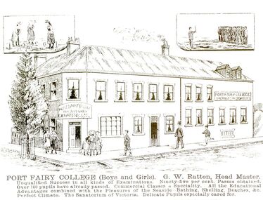
... (The Stag built 1848-1853.Land was purchased from Atkinson to build a licensed premises, it later became a boarding house also a boarding school now is used mainly as accommodation and also a Restaurant ) hotel stag seacombe inn boarding school sackville street cox street Port Fairy College (Boys and Girls) G.W.Ratten Headmaster. I qualified success in all kinds of examinations. Ninety five per cent passes obtained. Over 100 pupils already passed. Commercial classes a speciality. All the educational advantages combined with the pleasures of the seaside, bathing ...This card was probably used as an advertisement. (The Stag built 1848-1853.Land was purchased from Atkinson to build a licensed premises, it later became a boarding house also a boarding school now is used mainly as accommodation and also a Restaurant )Black and white photograph of a drawing of Seacombe House as Port Fairy College with large descriptionPort Fairy College (Boys and Girls) G.W.Ratten Headmaster. I qualified success in all kinds of examinations. Ninety five per cent passes obtained. Over 100 pupils already passed. Commercial classes a speciality. All the educational advantages combined with the pleasures of the seaside, bathing, shelling, beaches & c. Perfect climate. The Sanatorium of Victoria. Delicate pupils especially cared forhotel, stag, seacombe, inn, boarding school, sackville street, cox street -
 City of Melbourne Libraries
Photograph, Bull, Hugh Jones, 1897-1993, Princes Bridge Centenary pylons under construction
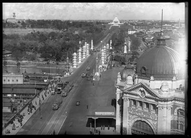
... House would be visible. *Catani was born in Florence in 1852, but after arriving in Melbourne worked as a civil engineer for the Victorian Government. His last major project was the reclamation of the foreshore of St Kilda, envisaged in the style of a European resort, complete with a split level esplanade, bathing pavilions, dance halls, amusements and a French-Italian style of landscape complete with palms. ...House would be visible. *Catani was born in Florence in 1852, but after arriving in Melbourne worked as a civil engineer for the Victorian Government. His last major project was the reclamation of the foreshore of St Kilda, envisaged in the style of a European resort, complete with a split level esplanade, bathing pavilions, dance halls, amusements and a French-Italian style of landscape complete with palms. ...Princes Bridge Centenary pylons under construction Possibly taken from Young and Jacksons Hotel (formerly Princes Bridge Hotel) on the corner of Flinders and Swanston streets, Flinders Street Station’s clocks and main entrance dominate, along with its distinctive copper dome and decorative façade. The time on the main clock is 1.40pm, and the sign underneath, reflecting Melbourne’s upcoming Centenary reads, “We must accommodate our Centenary visitors! Citizens! Do your share by taking paying guests.” At left is the original Princes Bridge Station, today the site of Federation Square. The riverside tram terminus advertises a Café/Tobacconist/Refreshment Room selling cigars & cigarettes, fountain drinks & confectionery, and in smaller text: “Leave your boot repairs here”. Nearly everyone is dressed in dark suits, coats and hats. The footpaths are wide and there are no traffic lights. The roadway stretches towards the Shrine of Remembrance, not yet dedicated but very dominant on the skyline. Government House is clearly visible across the wide parkland that would come to be known as Kings Domain and that is an area of deep importance to the people of the Eastern Kulin. Originally, Birrarung was part of a network of swamps and lagoons linked to the course of the river. From 1896, Public Works Department engineer Carlo Catani, oversaw a new channel to straighten the river and the swamps and lagoons were filled with spoil from the channel works. From the same vantage point today, only the top of the tower of Government House would be visible. The photo captures the pylons along Princes Bridge, mid-construction and being installed to mark Melbourne’s Centenary. The pylons were not without controversy. Both The Argus and The Age bemoaned them for being “made almost entirely of imported softwood timber”, denying work to native hardwood timber workers and sawmillers, and leading visitors to think Australia did not have its own exceptional native hardwoods. The pylons were also variously described in their incomplete state, as unimaginative and resembling an oilfield. Published: The Age 5 September 1934 Featured in "Newsworthy: Melbourne in photographs 1933-1936" exhibition at East Melbourne Library, October to December 2023. Exhibition caption by project volunteer, Louise McKenzie Photographer notations on slide: "Pylons + St Kilda Rd C57" Published: Age (Melbourne, Vic. : 1854 - 1954), Wednesday 5 September 1934, page 11 Published title: DECORATIONS -- THEN AND NOW. Published caption: "Although not completed yet, some impression of the effect of the decorations on Princes-bridge may be obtained from the first picture which shows the majestic sweep of St Kilda road with the Shrine of Remembrance and Government House dominating the horizon. The area to the left of St. Kilda-road and in front of Government House is portion of the area which it is proposed to call the King's Domain, which extends to Domain-road and Anderson-street..." Description: East-facing, elevated view of Flinders Street Station and Princes Bridge, featuring partially completed pylons erected for Melbourne's Centenary celebrations. The Shrine of Remembrance and Government House can be seen in the distance. In the foreground are trams, cars and trucks, pedestrians, Batman Avenue tram terminus and refreshment rooms. Signage on Flinders Street Station encourages citizens to accommodate Centenary visitors. The Melbourne Centenary was held 1934-35 in celebration John Batman's proclamation that Melbourne "the place for a village". Centenary events included a visit by Prince Henry, Duke of Gloucester. A Centenary Cake measuring 50 feet in height and ten tons in weight was cut into 250,000 pieces and sold at 1 shilling per piece for charity. Spectacular floodlighting of city landmarks, the creation of the Pioneer Women's Memorial Garden, and the MacRobertson Air Race from London, were other notable activities. Research by project volunteer, Louise McKenzie: The photo in The Age collage of 5 September 1934 has a slightly cropped foreground. The original photo has been taken from an elevated vantage point, most probably the roof of the Nicholas Building on the corner of Flinders and Swanston streets. The right foreground is dominated by the main “clocks” entrance to Flinders Street Station, showing its distinctive copper dome and decorative façade. The time on the main clock is 1.40 pm. The main sign on the front of the Station reads, "We Must Accommodate our Centenary Visitors! Citizens! Do your share by taking paying guests. Write to The Official Centenary Accommodation Bureau, 436 Collins St. City. Tel M 4671”. Another sign at eye level at the main entrance says: “Cheap Trips on Sundays”. The sign on the end of the roof along the eastern side of the station reads, “The Babies Need Your Help! Support Broadmeadows Foundling Hospital Appeal. July and August”. Run by the Sisters of St Joseph of the Sacred Heart, St Joseph’s Foundling Hospital was a purpose built infants’ home for up to 300 babies, plus accommodation for expectant mothers, mainly single women. In the early 1930s, the department (Victorian Children’s Welfare Department) contracted St Joseph’s Foundling Hospital to care for an additional 60 infant state wards, and up to 175 non wards at any given time. In 1931 it also operated a mothercraft training school. The centre foreground shows the commencement of Princes Bridge. Beneath the left side of the bridge was the site of the original Princes Bridge Station, by this time incorporated into Flinders Street Station, and today the area is the site of Federation Square. It was linked to Flinders Street station by the railway tracks that ran underneath the northern approach to the bridge. This photo shows a tram terminus which has a Café/Tobacconist/Refreshment Room, selling cigars & cigarettes, fountain drinks & confectionary, and a sign: Leave your boot repairs here. In the foreground is a wide roadway running south/north, comprising two vehicle lanes each heading north/south, and a central section containing two sets of tram tracks. There are cars, buses and delivery vans on the roadway. The trams visible are Glen Iris (Route No. 6; tram no. 448), Toorak (Route No. 8, tram no. 333), ? (No. 7), ? (No. 1), and ? (No. 2A). The footpaths are extremely wide. There is a square newspaper/magazine stand on the eastern side footpath. And also a “Ferry” sign. There are no traffic lights, but a policeman is visible on the roadway. There are pedestrians – men, women, children, a porter with trolley, women with prams. Clothing comprises dark suits, coats and hats for nearly everyone. There are double headed “Collins Street” lights along the side of the roadway, and along the northern riverbank. The roadway in the foreground is an extension of Swanston Street, which becomes Princes Bridge, then St Kilda Road, stretching towards the Shrine of Remembrance, and diverting past it. The Shrine had not yet been officially dedicated, and looks very white and dominant on the skyline. On the LHS of St Kilda Road, Government House is clearly visible across the wide parkland to be known as Kings Domain. The Kings Domain area is important to the people of the Eastern Kulin nation, and also has historical importance for its association with the early settlement of Melbourne and the foundation of British colonial administration in Victoria. On the southern side of the Yarra River (Birrarung) an historic rowing boathouse is visible, located adjacent to the Alexandra Gardens. Originally Birrarung was part of a network of swamps and lagoons linked to the course of the river. From 1896, under the guidance of engineer Carlo Catani* a new channel to straighten the river was created and the swamps and lagoons were filled with spoil from the channel works. The gardens were then created and completed in time for a Royal visit by the Duke of York in May 1901. The gardens are named after Alexandra of Denmark, the wife of King Edward VII. Both these areas, plus the Royal Botanic Gardens Victoria, Shrine of Remembrance Reserve, Sidney Myer Music Bowl, Government House, and the Queen Victoria Gardens together form the Domain Parklands. The extent of the subsequent plantings is evident today, where from the same vantage point only the top of the tower of Government House would be visible. *Catani was born in Florence in 1852, but after arriving in Melbourne worked as a civil engineer for the Victorian Government. His last major project was the reclamation of the foreshore of St Kilda, envisaged in the style of a European resort, complete with a split level esplanade, bathing pavilions, dance halls, amusements and a French-Italian style of landscape complete with palms. The gardens at the end of Fitzroy Street, St Kilda, now bear his name. The historic boathouse visible across the Yarra is another glimpse into Melbourne’s past. “Boathouse Row” comprises 7 amateur rowing clubs, the first established in 1859 (Melbourne University Boat Club). Other Clubs were Richmond, Melbourne, Banks, Melbourne Grammar School, Yarra Yarra and Mercantile. South of the river and west of the bridge is an area today developed into the Melbourne arts precinct of Hamer Hall and the Arts Centre. But at this time it was the home of Wirths Olympia Circus, which comprised Wirths Pleasure Park (an amusement park), a 5,000 seat auditorium – Hippodrome, a roller skating rink, a glaciarium, a cinema, and the Green Mill Dance Hall. Dog shows were also held at Olympia. The Green Mill Dance Hall closed in 1950, and the remainder of the Wirth buildings on site were destroyed by fire in December 1953. The feature of the photo is the pylons erected along Princes Bridge to mark Melbourne’s Centenary in 1934. The sixteen plastered pylons were designed by Roy Prentice, the second person to qualify as an architect at The University of Melbourne’s Bachelor of Architecture degree, in 1933, aged 27. Simon Reeves in his article marking the 100th birthday of Roy Prentice on 20 June 2006 reports that the State Electricity Commission sponsored this work, and the Argus reported that “… the pylons were “illuminated from within to give the effect of soft radiance”. Australia Home Beautiful 1 Oct 1934 reports in a very detailed and comprehensive article: The 10 taller pylons, including flagpole, were 48 ft, with a base of 8 ft. Timber-framed and faced with fibrous plaster and galvanised sheet iron, each structure was securely bolted to a concrete foundation three feet in depth. Panels of glass let into the shaft of each pylon were indirectly lit by 40, 100 watt lamps, and the upper bank of internal lamps were dyed so as to flood the panels with a deep red light. The decorative painted shields and flagpoles/pennants were illuminated by three 200 watt projectors concealed in the roof of each pylon, and were part of an electric night light decoration scheme involving 28 miles of wire to supply more than 20,000 lights. An article in the Argus on 18 October 1934 provided minute detail of the lighting erected in Melbourne for the Centenary, converting it “… into a coloured fairyland by night.” The estimated cost of 10 pounds per hour the lights were on. The display included 800 standard light poles 30 feet high which were tiered with electric bulbs concealed in inverted cones, 138 specially designed “Venetian poles” draped in flags trophies and streamers. The streets included in the electric night light decoration scheme were Bourke Street from Spring to William, the entire length of Collins Street, Flinders Street from Elizabeth to Spring, Lonsdale Street from Elizabeth to Swanston, Swanston and Elizabeth Streets from Flinders to Lonsdale, and parts of Springs and Spencer Streets. Together with the Princes Bridge pylons, approximately 28 miles of wire was required to supply power to the more than 20,000 lights. And that is just in the city of Melbourne. It was estimated the same amount of lighting was duplicated among other local councils. The pylons were not without controversy. The Argus on 28 August 1934 in an article headed “Imported Timber in Pylons” reported that the Princes Bridge pylons are “made almost entirely of imported softwood timber”, and have therefore denied work to native hardwood timber workers and sawmillers. The same day the Melbourne Age ran a similar story, bemoaning the fact that foreign oregon had been used which may lead tourists to think Australia did not have its own exceptional native hardwoods. A Camberwell City Councillor described the pylons as unimaginative, and the Herald reported that skeletons of pylons for the Centenary decorations in their present form led the area to resemble an oilfield! The Yarra River and Princes Bridge have long been a focal point of Melbourne life. In the early days of European settlement in Melbourne a rope-hauled punt carried people across the Yarra River. A surge in population and increased shipping traffic created a need for a bridge. There was difficulty in agreeing on a suitable site for the bridge (options were crossing at Elizabeth, Swanston, Queen or Market Streets), but the NSW Government favoured Swanston Street and the Melbourne Town Council decided on a temporary bridge across the Yarra spanning from the foot of Swanston Street. This first bridge was a single span timber toll bridge designed by Scottish born bridge designer David Lennox, and completed in 1845. It was 120 feet long, had a roadway of 17 feet wide, and a footpath on one side of 4 feet. It was leased to the Melbourne Bridge Company in the name of Robert A Balbirnie. The tollhouse was on the north side of the river and the toll keeper, Patrick Doherty, was credited with saving nine lives during the four years he was in charge of the toll station. The second bridge was stone (completed 1850), and named Prince’s Bridge after the HRH Prince of Wales, later Edward VII. It was designed with an elliptical single arc and an exceedingly small rise in proportion to the span. However, this design created an obstacle for flood waters, and together with Melbourne’s increasing population it was quickly apparent that a new bridge was required. At its opening on 15 November 1850 coincided with the imminent declaration of Victoria as a separate colony, it provided a moment of great celebration for Melbournians and “The opening ceremony was described as the grandest processional display witnessed in the colony.” (ToMelbourne.com.au) Princes Bridge in its present form, as depicted in this photograph, was designed by Jenkins, D’Ebro and Grainger, and constructed in 1886-88 by David Munro. John Grainger (father of Australian composer Percy Grainger) did the majority of the design work for the bridge. The structure was to have three arches each 96 feet wide measured across the river, and the banks on both sides were raised to allow more space for floodwater to flow. St Kilda Road was originally many feet below the current level. The bridge is of architectural significance for its substantial size, giant half columns, extensive use of wrought and cast iron, decorative elements (cast-iron lamps) and the skilled stonemasonry in the construction of the abutments and piers. Its main design features are similar to those of Blackfriars Bridge in London (1870). The bluestones were quarried from Footscray, the Malmsbury stones were from quarries at Kyneton, and the granite from Harcourt. The cost was met by the State of Victoria, City of Melbourne, and six out of seven of its municipalities, and their coats of arms feature on the bridge. The building of the bridge reflected the boom period of Melbourne, including the Victorian gold rush 1851- late 1860s, and its contractor, David Munro, was also responsible for the construction of Queens Bridge and Sandridge Railway Bridge. The Centenary pylons are no longer in place, but today this intersection still plays a major part in Melbourne’s daily life: people still meet “under the clocks” at Flinders Street station, and the route in and out of the city along St Kilda Road is often a feature of parades such as Moomba, the Grand Final Parade, and of course the Anzac Day Parade which commences at the Princes Bridge intersection and finishes at the Shrine of Remembrance. There are many tram routes, which cross the Bridge, and it directs pedestrians towards the Arts Precinct, the various components of Domain Park, plus the Southbank restaurant and rowing precincts. Even though this is a street scene, it feels very intimate; the viewer is instantly immersed in the activity of a Melbourne afternoon, looking down St Kilda Road from a viewpoint near today’s Federation Square. References: DECORATIONS -- THEN AND NOW. (1934, September 5). The Age (Melbourne, Vic. : 1854 - 1954), p. 11. Retrieved September 21, 2023, from http://nla.gov.au/nla.news-article205880269 'Flinders Street railway station', Wikipedia, https://en.wikipedia.org/wiki/Flinders_Street_railway_station 'St Joseph’s Foundling Hospital (1901-75)', Finding Records, Department of Health and Human Services, State of Victoria, https://www.findingrecords.dhhs.vic.gov.au/collectionresultspage/St-JosephsFoundling-Hospital-Babies-Home#departmental-administration 'Alexandra Gardens', City of Melbourne, https://www.melbourne.vic.gov.au/community/parks-open-spaces/major-parks-gardens/Pages/alexandra-gardens.aspx 'Wirths Circus', Wikipedia, https://en.wikipedia.org/wiki/Wirth's_Circus 'Roy Prentice: Centenary Architect', Built Heritage Pty Ltd, Simon Reeves, https://www.builtheritage.com.au/downloads/prentice.pdf 'Princes Bridge', Heritage Council Victoria, https://vhd.heritagecouncil.vic.gov.au/places/817 PORT PHILLIP. (1846, April 1). The Sydney Morning Herald (NSW : 1842 - 1954), p. 3. Retrieved September 21, 2023, from http://nla.gov.au/nla.news-article12886251 'Edward VII', Wikipedia, https://en.wikipedia.org/wiki/Edward_VII 'Princes Bridge', ToMelbourne.com, https://tomelbourne.com.au/princes-bridge/ 'Princes Bridge', eMelbourne, https://www.emelbourne.net.au/biogs/EM01189b.htm 'Princes Bridge', Australia for everyone, http://australiaforeveryone.com.au/files/melbourne/princes-bridge.html 'Victorian gold rush', Wikipedia, https://en.wikipedia.org/wiki/Victorian_gold_rush IMPORTED TIMBER IN PYLONS (1934, August 28). The Argus (Melbourne, Vic. : 1848 - 1957), p. 9. Retrieved September 21, 2023, from http://nla.gov.au/nla.news-article10952507 Princes-Bridge Pylons. (1934, August 28). The Age (Melbourne, Vic. : 1854 - 1954), p. 7. Retrieved September 21, 2023, from http://nla.gov.au/nla.news-article205532235 Pylons Appear Near Princes Bridge (1934, August 18). The Herald (Melbourne, Vic. : 1861 - 1954), p. 1. Retrieved September 21, 2023, from http://nla.gov.au/nla.news-article243104375 PRINCES-BRIDGE PYLONS. (1934, September 20). The Age (Melbourne, Vic. : 1854 - 1954), p. 10. Retrieved September 21, 2023, from http://nla.gov.au/nla.news-article205873535 28 Miles of Wire (1934, October 18). The Argus (Melbourne, Vic. : 1848 - 1957), p. 1 (The Junior Argus). Retrieved September 21, 2023, from http://nla.gov.au/nla.news-article10977836 'Historical references for Boathouse Row, Melbourne', http://boathouserowmelbourne.com.au/history/ 'ITALIAN DELEGATION TO HONOUR CARLO CATANI, DESIGNER OF THE ST KILDA FORESHORE, St Kilda Historical Society, 2001, https://web.archive.org/web/20070928061938/http://www.skhs.org.au/~SKHSarticles/articles/Carlo_Catani.html# HISTORY IN LIGHTS (1934, July 12). The Herald (Melbourne, Vic. : 1861 - 1954), p. 16. Retrieved September 21, 2023, from http://nla.gov.au/nla.news-article243172436 'Dressing Melbourne for the Duke', The Australian home beautiful: a journal for the home builder. Vol 12 No. 10 (1 October 1934), page 21, 58. Retrieved September 14, 2023, from http://nla.gov.au/nla.obj-2950922209Photographer notations on slide: "Pylons + St Kilda Rd C57".centenaries, bridges, lighting, flinders street railway station
