Ballan Shire Historical Society
Map - Map. Shire of Ballan, Shire of Ballan
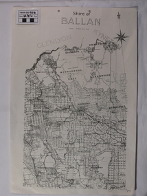
... ...bayup...Ballan Shire Historical Society 45-47 Steiglitz St Ballan goldfields This is a fairly comprehensive map of the former Shire of Ballan which is now amalgamated into the Shire of Moorabool. gordon ballan bungal kerrit bareet borhoneyghurk bungeeltap ballark yaloak gorong beremboke wallace ingliston hunterston millbrook bradshaw myrniong blackwood moorarbool greendale bayup trentham bullarto korweinguboora glenlyon bolwarra A black and white map of the Shire of Ballan showing major roads, rivers, towns, settlements, State parks and forests and land subdivisions.
...
This is a fairly comprehensive map of the former Shire of Ballan which is now amalgamated into the Shire of Moorabool.A black and white map of the Shire of Ballan showing major roads, rivers, towns, settlements, State parks and forests and land subdivisions.
It appears to be a copy of the original as no dates or maker or printer appear on the map.
There is a scale of 2 miles to 1 inch.gordon, ballan, bungal, kerrit bareet, borhoneyghurk, bungeeltap, ballark, yaloak, gorong, beremboke, wallace, ingliston, hunterston, millbrook, bradshaw, myrniong, blackwood, moorarbool, greendale, bayup, trentham, bullarto, korweinguboora, glenlyon, bolwarra