Showing 11 items matching "beachside"
-
 Kew Historical Society Inc
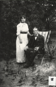
Photograph, Beachside Study, 1900-1920
... Beachside Study...A beachside study, ca. 1900-ca. 1920. An unknown couple pose in a beachside setting for the photographer. ...Kew Historical Society Inc Kew Court House 188 High Street Kew melbourne The print image was taken from a glass negative in the collection which is part of a set donated to the Society by Ian McKenzie, a professional photographer in Kew. glass negatives A beachside study, ca. 1900-ca. 1920. An unknown couple pose in a beachside setting for the photographer. ...The print image was taken from a glass negative in the collection which is part of a set donated to the Society by Ian McKenzie, a professional photographer in Kew. A beachside study, ca. 1900-ca. 1920. An unknown couple pose in a beachside setting for the photographer. The man sits in a deck chair while the woman stands at his side. Some degradation of the original glass negative is apparent in the print that has been taken from it. glass negatives -
 Chelsea & District Historical Society Inc
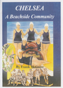
Book, Frank McGuire, Chelsea a Beachside Community, 1985
... Chelsea a Beachside Community ...Chelsea: a Beachside Community, is the result of much research by the honorary historian of the City of Chelsea Historical Society Inc, Frank McGuire B.E.M....Early settlers Book soft cover life savers in costume with a lifesaving reel Chelsea a Beachside Community Book Book Frank McGuire Chelsea and District Historical Society Inc ...Chelsea: a Beachside Community, is the result of much research by the honorary historian of the City of Chelsea Historical Society Inc, Frank McGuire B.E.M.History of Chelsea, first land sales in 1875, highlights of Chelsea history up to 1985.Book soft cover life savers in costume with a lifesaving reel chelsea & district historical society inc., early settlers -
 Melbourne Legacy
Film - Video tape, Legacy Somers Camp January 2002, January 2002
... A visual record of the activities experienced by Junior Legatees at the Legacy beachside camp....Melbourne Legacy 293 Swanston Street Melbourne melbourne A visual record of the activities experienced by Junior Legatees at the Legacy beachside camp. A record of a camp that Legacy regularly ran for junior legatees. somers camp junior legatee outing Cover. ...A visual record of the activities experienced by Junior Legatees at the Legacy beachside camp.A record of a camp that Legacy regularly ran for junior legatees.A VHS video of Somers Camp in 2002 in cardboard cover.Cover. TEAC,white print, ASX,3 hours, Lifetime Warranty printed in white red highlight, E- 180, video cassette, super high definition in yellow print, SP. 3 hours, VHS LP. 6 hours, PAL SECAM. Video Cassette. Teac insert this side into recorder do not touch the tape inside, VHS, ASX. Label, TEAC, ASX, Legacy Somers Camp January 2002, mono, bilingual, pcm, date, stereo, hi-fi, bs. Label. TEAC, Legacy Somers Camp January 2002, VHS, pal secam. somers camp, junior legatee outing -
 Melbourne Legacy
Film - Video tape, A Summers Day at Somers. Legacy holiday camp Jan 2001, January 2001
... A visual record of Junior Legatees enjoying a beachside holiday at Somers Camp. The tape has not been viewed....Melbourne Legacy 293 Swanston Street Melbourne melbourne A visual record of Junior Legatees enjoying a beachside holiday at Somers Camp. The tape has not been viewed. ...A visual record of Junior Legatees enjoying a beachside holiday at Somers Camp. The tape has not been viewed.A record of Melbourne Legacy holding camps for the junior legatees in their care.A VHS video tape about Somers Camp in 2001, in a cardboard cover.Cover, TDK, SC, SHARP&CLEAR, label A SUMMERS DAY AT SOMERS Legacy Holiday Camp Jan 2001. Cover rear, SC SHARP&CLEAR, TDK, VHS. Label x 2. A SUMMERS DAY AT SOMERS Legacy Holiday Camp Jan 2001.somers camp, junior legatee outing -
 City of Kingston
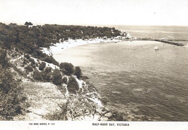
Postcard - Postcard, Colour, Rose Stereographs, Half-Moon Bay, Victoria, c. 1920
... ...Beachside...This postcard appears to be one in a set of postcards promoting the Black Rock area. Black Rock Beachside Foreshore Holiday Postcard Sepia toned postcard depicting Half Moon Bay at Black Rock. ...Postcards began to be produced in Victoria from 1876. Between 1900 and 1920, picture postcards in Australia became an incredibly popular phenomenon. People could cheaply and easily send messages, without the formality of a letter, and they provided a cheap form of souvenir. Eventually, every event of significance was commemorated in some way with a postcard, and this led to the development of a ‘picture on one side and a message/stamp on the other’ postcard we are familiar with today. They were also a popular form of advertising. This postcard appears to be one in a set of postcards promoting the Black Rock area.Sepia toned postcard depicting Half Moon Bay at Black Rock.black rock, beachside, foreshore, holiday, postcard -
 Chelsea & District Historical Society Inc
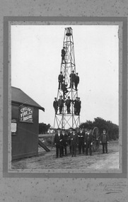
Photograph - Chelsea Fire Brigade, Members of the Chelsea Fire Brigade standing in front of the of the Fire station, on the bell and the hose tower, c 1920
... The Chelsea Fire Brigade in Victoria, Australia, began as a volunteer unit around 1912 to serve the growing beachside suburb. Officially registered with the Country Fire Brigades Board in 1925, the brigade was a vital community service for decades. ...The Chelsea Fire Brigade in Victoria, Australia, began as a volunteer unit around 1912 to serve the growing beachside suburb. Officially registered with the Country Fire Brigades Board in 1925, the brigade was a vital community service for decades. ...The Chelsea Fire Brigade in Victoria, Australia, began as a volunteer unit around 1912 to serve the growing beachside suburb. Officially registered with the Country Fire Brigades Board in 1925, the brigade was a vital community service for decades. In March 2006, the brigade amalgamated with the Carrum Fire Brigade to form the Patterson River Fire Brigade. Black and White photo of the members of the Chelsea Fire Brigade, standing in front of the station which was situated on Point Nepean Road. Four members Have been identified: Standing on ground from the right, Captain J. J. Smith, Frank Jennings, Mr Frickie, Zeke Smith.firefighters, chelsea, chelsea fire brigade, fireman, fire equipment -
 Chelsea & District Historical Society Inc
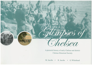
Book, G.Whitehead, Glimpses of Chelsea, 2007
... In the early years our beachside suburb was popular with groups and families. ...In the early years our beachside suburb was popular with groups and families. ...Photos and descriptions of historical buildings Chelsea District Historical Society is fortunate to have many photos that have been donated and collated over the last fifty years. In the early years our beachside suburb was popular with groups and families. Camping & holidaying in guest houses or privately rented houses. This book includes photographs of local people, beaches, churches, clubs, sports, hotels, railways, industry, hospitals and halls, and many other pictures of local scenes. A unique history of the District of Chelsea. Photographs show the beginnings and how the Chelsea district was developed. Various Sporting clubs and groups, businesses, buildings, streets and early European settlers and others. Large soft cover book A pictorial history of early Chelsea & District first printed 2007aspendale, carrum, bonbeach, edithvale, chelsea -
 City of Kingston
Photograph - Colour, 29 January 1993
... Bonbeach is a small beachside suburb located between Chelsea and Carrum. ...City of Kingston Parkdale Library 96 Parkers Road, Parkdale Parkdale Bonbeach is a small beachside suburb located between Chelsea and Carrum. ...Bonbeach is a small beachside suburb located between Chelsea and Carrum. The station was opened in 1926 and was the last to be established in the group from Aspendale to Carrum. Urban growth began after World War II. State primary and high schools were opened in 1958 on land in Breeze Street that was once occupied by The Australian Glass Manufacturers. Immediately east of the school sites is the Patterson River Golf Club. The Bonbeach sports reserve has five ovals and is home to the Bonbeach football and baseball clubs. The suburb borders the Edithvale-Seaford Wetlands which is the remnant site of the Carrum Carrum swamp, once the home of the Bunurong people.Bonbeach was originally a seaside destination for holidaymakers and the housing comprised of holiday homes and gradually more permanent residents. It was not until 1926 that Bonbeach had its own railway station. From 1906 until the late 1940s sand was quarried on the east side of the railway line and used in the manufacture of glass. The Australian Glass Manufacturers sold this land in residential blocks and Bonbeach's permanent population spread from the coastal strip across to the other side of the railway line. Laminated colour aerial photograph of the suburb of Bonbeach and also the southern section of neighbouring Chelsea within the City of Kingston. The extent of this 1993 aerial image includes: Top left - Maury Road at the south end of the Chelsea shopping Centre; Top right - Scotch Parade Chelsea Bottom left - Monica Avenue in Bonbeach; Bottom right - Patterson River Golf Club. Landmarks include St Joseph's Church and Primary School, Chelsea Primary School, Bonbeach Station, Bonbeach Fotball Club sports playing fields and Bonbeach Life Saving Club. The Edithvale Wetlands is featured prominently to the right-hand side of the image. Black typed writing on white adhesive label: No. 6662 Black typed writing on white adhesive label: 26E/6662, 29/1/93, 4.25 pm Black typed writing on white adhesive label: 29-1-93 Black typed writing on white adhesive label: P000109 Circular yellow adhesive sticker bonbeach, chelsea -
Glen Eira Historical Society
Article - Prentice Street, 30, Elsternwick
... Listed as outstanding development potential by Buxton Estate Agents, coloured photo of exterior included. 2/Property Review Weekly feature, dated 14/02/2003, includes two coloured photographs (one exterior and one interior) for sale of renovated property, beachside architecture; agent Hocking Stuart. ...Listed as outstanding development potential by Buxton Estate Agents, coloured photo of exterior included. 2/Property Review Weekly feature, dated 14/02/2003, includes two coloured photographs (one exterior and one interior) for sale of renovated property, beachside architecture; agent Hocking Stuart. ...Three items about sales of this property: 1/Property Review Weekly, advertising dated 15/06/01, on forthcoming executors auction 24/06/2001. Listed as outstanding development potential by Buxton Estate Agents, coloured photo of exterior included. 2/Property Review Weekly feature, dated 14/02/2003, includes two coloured photographs (one exterior and one interior) for sale of renovated property, beachside architecture; agent Hocking Stuart. Also an advertisement, dated 26/02/2003, giving brief house features of property renovation and colour photo of front exterior. 3/Two ads for sale of property in November 2014. One is hand-daterd 2014 with front and back colour exterior photos plus one colour interior of this architect-designed home. The other is dated 21/11/2014 with same photos but different description.prentice street, franzi craig, elsternwick, kingston phillip, architecture, hocking stuart, victorian style, estate agents, timber houses, hocking stuart, architects -
City of Kingston
Photograph - Colour, Circa 1993
... The large blocks are increasingly subdivided and the existing dwellings demolished to accommodate units and townhouses, thus changing the landscape of the area and reducing the tree canopy. The beachside suburb of Edithvale was previously part of the extensive Carrum Carrum Swamp. ...Edithvale is a suburb in the City of Kingston. It is located between Aspendale and Chelsea on the Port Phillip Bay and built within remnant areas of the Carrum Carrum swamp. The foreshore precinct comprises a wide sandy beach, with low sand dunes and numerous historic boat sheds. The suburb consists of older style dwellings and former holiday houses, combined with mid-century housing and newer homes. The large blocks are increasingly subdivided and the existing dwellings demolished to accommodate units and townhouses, thus changing the landscape of the area and reducing the tree canopy.The beachside suburb of Edithvale was previously part of the extensive Carrum Carrum Swamp. The area was once a source of fish and eels for the Mayone-Bulluk clan of the Bunurong people. Over time the area was drained and predominantly devoted to dairy farming and holiday houses. The farms were gradually sold and subdivided with a large number of homes built after World War II and in the 1960s. Edithvale is mainly residential with a shopping strip along Nepean Highway but little significant industry was ever established in the area apart from a plaster works and confectionary factory, both now closed.Aerial colour photograph of Edithvale as viewed from Alexandra Avenue in the north to Ella Grove Chelsea/Edithvale in the south. The area is built-up with residential housing and facilities including Edithvale Primary School, numerous churches and the Edithvale Railway station. Large sections depict the remnant Carrum Carrum swamp. Edithvale Common and the former "Duck Inn" (Melbourne Water/Friends of Edithvale Seaford Wetlands) can be seen. Edithvale Recreational reserve, the velodrome and Edithvale Public Golf Course are prominent. The image shows vacant land in the area now known as Aspendale Gardens and the newer residential section of Chelsea Heights is not developed. A bike path has been established to cover the secondary drain. The Golf Links Court residential development located off Hughes Avenue is a large vacant block.Yellow circular adhesive sticker on plastic Black ink (marker): * (asterisk) Black type on white adhesive sticker: P000108edithvale, aspendale, chelsea, carrum carrum swamp -
City of Kingston
Photograph - Colour, 6 March 1993
... The large blocks are increasingly subdivided and the existing dwellings demolished to accommodate units and townhouses, thus changing the landscape of the area and reducing the tree canopy. The beachside suburb of Edithvale was previously part of the extensive Carrum Carrum Swamp. ...Edithvale is a suburb in the City of Kingston. It is located between Aspendale and Chelsea on the Port Phillip Bay and built within remnant areas of the Carrum Carrum swamp. The foreshore precinct comprises a wide sandy beach, with low sand dunes and numerous historic boat sheds. The suburb consists of older style dwellings and former holiday houses, combined with mid-century housing and newer homes. The large blocks are increasingly subdivided and the existing dwellings demolished to accommodate units and townhouses, thus changing the landscape of the area and reducing the tree canopy.The beachside suburb of Edithvale was previously part of the extensive Carrum Carrum Swamp. The area was once a source of fish and eels for the Mayone-Bulluk clan of the Bunurong people. Over time the area was drained and predominantly devoted to dairy farming and holiday houses. The farms were gradually sold and subdivided with a large number of homes built after World War II and in the 1960s. Edithvale is mainly residential with a shopping strip along Nepean Highway but little significant industry was ever established in the area apart from a plaster works and confectionary factory, both now closed.Laminated aerial colour photograph of Edithvale as viewed from Alexandra Avenue in the north to Ella Grove Chelsea/Edithvale in the south. regents Park Aspendale can be seen in the top left. The area is built-up with residential housing and facilities including Edithvale Primary School, numerous churches and the Edithvale Railway station. Large sections depict the remnant Carrum Carrum swamp. Edithvale Common and the former "Duck Inn" (Melbourne Water/Friends of Edithvale Seaford Wetlands) can be seen. Edithvale Recreational reserve, the valodrome and Edithvale Public Golf Course are prominent. The image shows vacant land in the area now known as Aspendale Gardens and the newer residential section of Chelsea Heights is not developed. A bike path has been established to cover the secondary drain. The Golf Links Court residential development located off Hughes Avenue is a large vacant block.Black type on white adhesive label: 6-3-93 Black type on white adhesive label: 25/9211, 6/3/93, 11.20 am Black type on white adhesive label: 9211 Yellow circular adhesive sticker Black pencil: 9211 6-3-93 arrow pointing Nedthvale, carrum carrum swamp, aspendale, chelsea