
Showing 16 items matching "beacon hill"
-
 Federation University Historical Collection
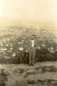
Photograph, Frank Wright on Beacon Hill, Great Malvern, 1934, 05/07/1934
... Frank Wright on Beacon Hill, Great Malvern, 1934......beacon hill...The man is Frank Wright and the place is Beacon Hill overlooking Great Malvern....Written in pencil on the back - Au, Frank Wright on Beacon Hill, Great Malvern, 5.7.34...The man is Frank Wright and the place is Beacon Hill overlooking Great Malvern. Frank Wright on Beacon Hill, Great Malvern, 1934 Photograph Great Malvern ...Frank Wright was a renown resident of Smeaton, where he was born. He lived at Laura Villa, and attended Smeaton State School. His father William was a gold miner and his mother's name was Sarah. Their family won many singing and instrumental awards. Frank was tutored by Percy Code and was awarded a gold medal for the highest marks in the ALCM examinations in the British Colonies at the age of seventeen years. He became the Australian Open Cornet Champion by the age of eighteen. A year later, Frank conducted the City of Ballarat Band, and later the Ballarat Soldiers’ Memorial Band. He formed the Frank Wright Frisco Band and Frank Wright and his Coliseum Orchestra. These bands won many South Street awards, and Frank as conductor won many awards in the Australian Band Championship contest. In 1933 Frank Wright sailed to England to conduct the famous St Hilda’s Band and was later appointed Musical Director of the London County Council, where he organized many amazing concerts in parks, in and around the London district. He was made Professor of Brass and Military Band Scoring and conducted at the Guildhall of Music and Drama. Frank was often invited to adjudicate Brass Band Championships around Europe, in Australia, including South Street and in New Zealand. The Frank Wright Medal at the Royal South Street competition is awarded to an individual recognized as making an outstanding contribution to brass music in Australia.Black and white photograph of a man dressed in a suit and standing in a cleared area on a hill with small shrubbery behind and then the far background is made up of a township and fields. The man is Frank Wright and the place is Beacon Hill overlooking Great Malvern.Written in pencil on the back - Au, Frank Wright on Beacon Hill, Great Malvern, 5.7.34frank wright, conductor, beacon hill, great malvern -
 Eltham District Historical Society Inc
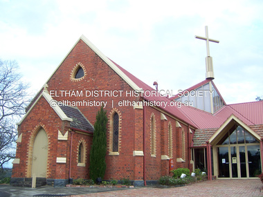
Photograph - Digital Photograph, Marguerite Marshall, St John's Anglican Church, Diamond Creek, 7 September 2008
... .; p85 St John’s Anglican Church stands like a beacon on the hill on Main Street, Diamond Creek. ....; p85 St John’s Anglican Church stands like a beacon on the hill on Main Street, Diamond Creek. ...The building was designed by Charles Maplestone of Heidelberg, son-in-law to Anthony Beale of St Helena. Maplestone was a prominent architect who came out to Australia with his family in 1852. The foundation stone was laid by Mrs Isabella Maplestone on 11th November 1867. The bricklayers for the church were George Stebbing, H Limmer, H Spicer and a Mr Timm while Thomas Day was the stonemason. Another three years were to pass before sufficient money could be raised for its completion. It was opened by Bishop Perry on 1st November, 1870. The church bell which hung under a tree for 50 years until it was incorporated in the parish hall was brought out from England and presented by Charles Orme. In 1916, the estate of George Martin Pizzey left sufficient money to build the red brick hall, which still stands today (2023) though in January 1969 the hall and bell tower were badly damaged by bushfire. Coincidentally the former home of benefactor, George Pizzey was destroyed in the same fire. Of particular significance are the interior and exterior of the church, the Sunday school and hall with emphasis on pre-World War I fabric (excluding the 1990s additions) and the three coloured glass windows currently suspended in the 1990s entry foyer. In 2011 further alterations were made to the front of the Church. The church is historically significant because it was the oldest public building in the former Diamond Valley Shire, is amongst the oldest buildings in the Shire of Nillumbik and is associated with the early settlement of the Diamond Creek district. The church is historically, socially and spiritually significant because it has been a place of worship for over 150 years and continues to be, an important meeting place in the Shire. The church is aesthetically significant for the three stained glass windows executed by the noted stained glass manufacturers, Ferguson & Urie, as well as the supporting coloured glass windows in the church. The Sunday school & parish hall is architecturally significant because the hall is a well executed and preserved example of the work of noted church architects, North & Williams. It is historically significant because it is connected with local parishioner and Melbourne industrialist, George Pizzey, who bequeathed funds for its construction. Covered under Heritage Overlay, Nillumbik Planning Scheme. National Estate Ntionl Trust of Australia (Victoria) Local significance Published: Nillumbik Now and Then / Marguerite Marshall 2008; photographs Alan King with Marguerite Marshall.; p85 St John’s Anglican Church stands like a beacon on the hill on Main Street, Diamond Creek. Today the church has a large congregation, but its early years were marked by a small congregation struggling to find enough money to survive. It was gold in Diamond Creek that resulted in the building of this National Trust registered property.1 This church is far removed from William Wilson’s humble barn (later the Bowling Green) where the first Anglican church services were conducted – probably the first in the district.2 In the mid 19th century services were infrequent as the Rev Francis Hales, travelling on horseback, also conducted services elsewhere, including at Heidelberg, Coburg, Kinglake, Arthurs Creek, St Andrews and Kangaroo Ground. In 1860 Diamond Creek came under the jurisdiction of the Eltham Parish. Until the mid 1860s the Diamond Creek settlement included only about 20 families who were struggling farmers. But this changed when gold was found in 1862. Then the township grew to 200 families, including miners, civil administration workers and shopkeepers. The resulting growth of Church of England adherents prompted them to petition the Government in 1866 for land to build a church. The area chosen, on which the original building still stands, was at the centre of the proposed township. Today church leaders believe that this conspicuous location is one of the reasons for its exceptional growth. Prominent architect Charles Maplestone designed the building as he did the Presbyterian Church at Kangaroo Ground. St John’s, which is still intact, was built in the Gothic Revival style with the traditional rectangular plan of a central nave and sanctuary at the end. It is typical of small churches built in Victoria at that time, with polychromatic hand-made bricks, a porch, diagonal buttresses and a slate roof.3 The church was officially opened by Lord Bishop Perry on November 1, 1870. But during the next 40 years, due to the varying fortunes of gold mining, the church struggled to remain viable. In 1909 it separated from the Eltham Parish to form a parish with Greensborough. Life became more difficult with the privations of World War One. Then disaster struck in 1915 when fire destroyed the Diamond Creek Gold Mine, wiping out the major livelihood of most parishioners. However the church’s morale was lifted in 1916, when it received a bequest to build the red brick hall, from late parishioner and prominent leather manufacturer, George Pizzey. As prosperity grew, in 1924 the congregation separated from Greensborough, but they rejoined in the 1930s Depression. In the 1950s the wider population soared, impacting on St John’s, and it became a separate parish, becoming responsible for six churches at St Andrews, Hazel Glen, Hurstbridge, St Helena and Yarrambat. As parishioner numbers outgrew the building, extensions were added in 1989 and then in 1993, blending in well with the original building. Church members have made a huge contribution to the local community. John Ryan was a Heidelberg Shire Councillor for 25 years from 1931, Mayor in 1939 and headed several local sporting and other organisations. His son Jock became a clergyman and a local historian heading the Nillumbik Historical Society. Another parishioner, Dr Ted Cordner, came to Diamond Creek in 1920. One of his sons Donald, who was a local doctor, won the Brownlow Medal, was President of the Melbourne Cricket Club and President of the Melbourne Grammar School Council. Roy ‘Monty’ Vale was a state Liberal MP and was related to May Vale, a member of the Heidelberg School of Artists.4 In the early 21st century St John’s Anglican Church is one of the fastest growing congregations in Melbourne. References: St Johns Anglican Church complex, Sunday School and Parish Hall 61 Main Street DIAMOND CREEK, NILLUMBIK SHIRE. (2023, June 7). Retrieved from https://vhd.heritagecouncil.vic.gov.au/places/64023 Diamond Creek, VIC. – St John’s Anglican (2023, June 7). Retrieved from https://www.churchhistories.net.au/church-catalog/diamond-creek-vic-st-johns-anglican This collection of almost 130 photos about places and people within the Shire of Nillumbik, an urban and rural municipality in Melbourne's north, contributes to an understanding of the history of the Shire. Published in 2008 immediately prior to the Black Saturday bushfires of February 7, 2009, it documents sites that were impacted, and in some cases destroyed by the fires. It includes photographs taken especially for the publication, creating a unique time capsule representing the Shire in the early 21st century. It remains the most recent comprehenesive publication devoted to the Shire's history connecting local residents to the past. nillumbik now and then (marshall-king) collection, st john's anglican church, diamond creek -
 Flagstaff Hill Maritime Museum and Village
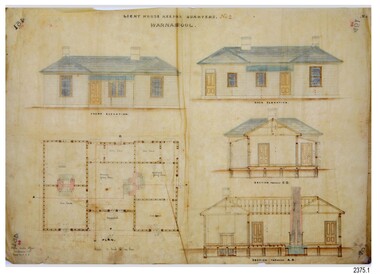
Document - Plans, Lighthouse Keeper's Quarters Warrnambool, 1858-1909
... Hill. In November 1857 the Victorian Government recommended that Warrnambool Harbour had beacons and two lighthouses to guide vessels into and out of the Harbour safely. ...Hill. In November 1857 the Victorian Government recommended that Warrnambool Harbour had beacons and two lighthouses to guide vessels into and out of the Harbour safely. ...The set of seven 1858 plans shows proposed plans for the original Lighthouse Complex that was built on Middle Island in 1858-1859. The whole complex was then transferred to Flagstaff Hill in 1871. The plan, dated 1909, is for proposed additions and repairs to the Quarters at Flagstaff Hill. The plan 'Alterations and Additions' shows alternate plans for changes to the quarters at the Flagstaff Hill location. This plan has no date. The Complex comprised the Lighthouse, the Lighthouse Keepers’ Quarters, the Store (now called the Chart Room) and a Privy, which was not included in these plans. The Keeper’s bluestone Quarters was a cottage divided into two compartments, one for each keeper and his family. The bluestone Store was divided into three; a store, a workshop an oil store (or office). The Privy comprised of a small building also divided into two separate, back-to-back toilets, one for each Keeper and his family. The Flagstaff Hill Keeper's Quarters have had extensions and additions at various times, and these have also been removed at various other times. THE PLANS - *Dec. 1858 (12/58) ‘Lighthouse Keepers Quarters No.2 Warrnambool’ (2375.01)* Public Works Office Melbourne – Front and Back elevations, sections, and floor plan. The drawing shows timber walls. [The floor plan is the closest plan to the current building, however, the walls are timber in this plan.] *Nov. 1858 – No.3 ‘Lighthouse Keepers Quarters Warrnambool’ (2375.02)* Office of Public Works, Melbourne – Back and End elevations and section through. The drawing shows stone walls. One side; Senior Keeper’s bedroom, living room and kitchen with storeroom. Another side; is the Assistant’s bedroom, living room and storeroom. *Nov. 1858 - No.4 ‘Lighthouse Stores Warrnambool’ (2375.03)* Office of Public Works – Front, Side and end elevations, centre section. The drawing shows stone walls. *Nov. 1858 – No.4, ‘Lighthouse Stores No. 2 Warrnambool’ (2375.04)* Office of Public Works – Front, side and end elevations, centre section. The drawing shows timber walls. *Nov. 1858 – ‘Details Lighthouse Keepers Quarters No. 2 Warrnambool’ (2375.05)* Public Works Office Melbourne. The plan shows the foundations, joists and eaves. The drawing shows timber walls. (Nov. 1858 – ‘No.4 ‘Lighthouse No. 2 – Warrnambool’ (2375.06)* Public Works Melbourne (Part of the paper is missing). This plan shows an octagonal tower, internal stairs, a balcony landing, and a weather vane on top. *November 1858 – No. 1, ‘Lighthouse – Warrnambool’ (2375.07)* Office of Public Works Melbourne. This plan shows a round tower, including the stairs, windows on the tower and the weather vane on the top. *4/3/9 [1909] – ‘Additions and Repairs, Lighthouse Quarters, Warrnambool, General Plan’ (2375.8)* Department of Public Works Melbourne’s official stamp is signed by Croft. It shows the floor plans of the Store, Upper Lighthouse and the Quarters. The Store building has three sections; a Store, Work-Shop and Office, with an internal wall between them and separate entries. The Quarters are divided into two dwellings. The Senior Keeper’s side on the left has fireplaces in two of the three bedrooms and there is a pantry and wash house. The Assistant’s side has no fireplaces in the bedrooms and there’s no pantry or washhouse. These plans include proposed changes to the buildings. The Senior Keeper’s Quarters would have a partition on bedroom 2, a bath with plumbing and drainage, a wall moved and a built-in side porch. The Store would also have a built-in porch. The undated plan 'Additions and Alterations' (2375.9) shows alternative arrangements for water tanks, plumbing and such. WARRNAMBOOL'S LADY BAY LIGHTHOUSES- In the 1800s ships sailing from England to Australia began to use Bass Strait as a faster route to Melbourne. Small navigation errors led to many tragic shipwrecks. From 1848 lighthouses were operating along Victoria’s southern coast as a guide for sailors. Coastal towns such as Warrnambool grew and the exchange of trade and passengers were of great benefit. However, the uncertain weather changes, relatively shallow waters and treacherous, hidden rocky reefs were not suitable for a Harbour and in the 1840s and 1850s there were many shipwrecks in the area, with some even stranded in its Lady Bay harbour. A jetty was built in 1850 and a flagstaff to guide seafarers was placed up high on what became known now as Flagstaff Hill. In November 1857 the Victorian Government recommended that Warrnambool Harbour had beacons and two lighthouses to guide vessels into and out of the Harbour safely. The white light of the Middle Island lighthouse was to be used for the first time on September 1, 1859. The red light of the Beach Lighthouse, a wooden obelisk structure, was first operated on March 25, 1860, but in 1868 this light was ‘discontinued’ due to it being too low. Melbourne’s Department of Public Works decided to relocate the Middle Island Lighthouse Complex - Lighthouse, Keeper’s Quarters, Privy, Store Room and even water tanks - to Flagstaff Hill. The lower obelisk was shortened, and a protruding gallery, railing, and external ladder were added, as well as the light from the Beach Lighthouse. A green guiding light was erected on the end of the jetty. The transfer of the Complex began in March 1871. Each shaped stone of the lighthouse was carefully numbered, removed then reassembled on Flagstaff Hill. In 1872 the well was sunk behind the Lighthouse Keeper’s Cottage. The Keepers and families had left Middle Island in April and moved to Flagstaff Hill in October 1871. Vessels entering Lady Bay align the Upper and Lower Lighthouse towers during the day and the lights at night. The Upper Lighthouse is a round tower, the Lower Light is square. The Lighthouses were categorised as harbour lights rather than coastal lights, so they remain under the control of the Victorian Government’s Ports and Harbours section. The lights were originally powered by oil, then acetylene gas, later by electricity, and then converted to solar power in 1988. In 1993 the solar panel was replaced by a battery charger. A decision was made in 1936 to replace the lighthouses’ lights with unattended lights that no longer required Keepers and Assistants. At least 29 Keepers had attended to the lighthouse from its opening in 1859 to when the last official Lightkeepers left In April 1916. The Warrnambool Harbour Board rented out the Quarters from 1916 to 1936. The Board closed down but the rentals continued with other unknown landlords. In the 1970s the Flagstaff Hill Planning Board was set up under the chairmanship of John Lindsay. The Board was to make recommendations to the Warrnambool City Council regarding the use of the buildings and the rest of the Crown Land on the site. The Flagstaff Hill Maritime Village opened in 1975 and began renovating the Cottage in stages, during which time evidence of a 1920s fire was found in the eastern section of the cottage. Additions of a porch on the west and a washroom on the east were made in the 1980s. The western part of the building is now a Shipwreck Museum and the east has returned to a late 19th-century Lighthouse Keeper’s cottage and includes the screen made by Assistant Lighthouse Keeper Thomas Hope during one of his two periods of service there. THE LIGHTHOUSE KEEPERS Lighthouse Keepers were responsible for keeping their Lighthouse’s lights shining at night. They kept a lookout for passing vessels and changes in weather. They were expected to clean, polish and maintain the equipment and buildings. They kept regular and detailed records of who was on watch, and the time the light was lit, trimmed and extinguished. They kept a journal about other events that occurred. They keep regular, accurate Meteorological Logs. It was expected that they were competent in Morse code signalling. They would be called to help in times of disasters and shipwrecks, and to give official statements about these events. Many Lighthouse Keepers also volunteered as members of the lifeboat crew. The Lady Bay lighthouses were officially classified as small, so the Keepers had the official titles of Senior Assistant Lighthouse Keeper and Assistant Lighthouse Keeper. They were employed by the Public Service and paid rent to live in the Lighthouse Quarters. They were compulsorily retired at the age of 60, with most receiving a superannuation payment. Despite their time-consuming duties, there was time to follow hobbies and crafts such as growing vegetables, playing musical instruments, making models of buildings including lighthouses, and crafting furniture pieces. An example of a keeper’s skills is the carved fire screen made by /assistant Keeper Thomas Hope in the early 20th century and displayed in the Lighthouse Keeper’s cottage at Flagstaff Hill. The last occupants of the Middle Island Complex were Senior Keeper Robert Deverell, his Assistant Keeper, Andrew Farncombe, and their families. They all became the first occupants at the Lady Bay Lighthouse Keepers’ Quarters on Merri Street. The Warrnambool Lighthouse Complex plans are the origin of what is now the Lady Bay Lighthouse Complex. They are a record of the people, process and departments involved in bringing the complex into fruition. The plans are significant to the Complex, which is now listed on the Victorian Heritage Register, H1520, for being of historical, scientific (technological) and architectural significance to the State of Victoria. The Complex is significant as an example of early colonial development. The plan are significant for their connection with the important navigational function of the Lighthouses, a function still being performed to this day. The plans are also significant as an example of a product from the Public Works Department in Victoria in the mid-to-late 19th century. The structures built to these plans still stand strong. Plans for the Lighthouse Complex in Warrnambool, including Lighthouses, Keeper's Quarters and Stores. Seven of the plans are on thin fragile paper, one is on thicker, stronger paper. The drawings have been made in pens coloured red and black. They originate from Public Works in Melbourne. Seven were drawn in 1858, one in 1904, the other is not dated.Dec. 1858 - Lighthouse Keepers Quarters No.2 Warrnambool. Public Works Office Melbourne. Nov. 1858 - No.3 ‘Lighthouse Keepers Quarters Warrnambool. Public Works Office Melbourne. Nov. 1858 - No.4 ‘Lighthouse Stores Warrnambool. Office of Public Works. Nov. 1858 - No.4, ‘Lighthouse Stores No. 2 Warrnambool. Office of Public Works. Nov. 1858 - Details Lighthouse Keepers Quarters No. 2 Warrnambool. Public Works Office Melbourne. Nov. 1858 - No.4 ‘Lighthouse No. 2 – Warrnambool. Public Works Melbourne. Nov. 1858 - No. 1, Lighthouse - Warrnambool. Office of Public Works Melbourne. 4/3/9 [1909] - Additions and Repairs, Lighthouse Quarters, Warrnambool, General Plan. Department of Public Works Melbourne. SIGNED "Croft" "15A" on reverse [no date] - Lighthouse Quarters Warrnambool, Additions and Alterations. "9A" on reverseflagstaff hill, warrnambool, lighthouse keeper's cottage, lighthouse residence, lighthouse, plans, public works, melbourne, flagstaff hill maritime museum, maritime museum, shipwreck coast, flagstaff hill maritime village, chart room, quarters, privy, middle island, beach lighthouse, obelisk, lighthouse keeper, assistant keeper, lighthouse complex, lady bay, lady bay complex, keepers, upper lighthouse, lower lighthouse, ports and harbours, cottage, harbour board, flagstaff hill planning board, meteorological record, robert deverell, andrew farncombe, warrnambool port, warrnambool harbour, residence, alterations, repairs, department of works, light keeper -
 Flagstaff Hill Maritime Museum and Village
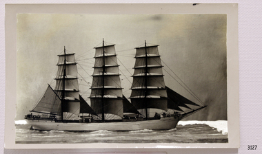
Photograph
... hill-maritime-village...Black and White Photograph...Beacon...flagstaff hill warrnambool shipwrecked-coast flagstaff-hill flagstaff-hill-maritime-museum maritime-museum shipwreck-coast flagstaff-hill-maritime-village Black and White Photograph Beacon Rock Black and White Photograph of the sailing ship Beacon Rock. 1400mm x 87mm. ...Black and White Photograph of the sailing ship Beacon Rock. 1400mm x 87mm. SH034 Ships A - B.flagstaff hill, warrnambool, shipwrecked-coast, flagstaff-hill, flagstaff-hill-maritime-museum, maritime-museum, shipwreck-coast, flagstaff-hill-maritime-village, black and white photograph, beacon rock -
 Flagstaff Hill Maritime Museum and Village
Photograph - Historical, building, Late 19th to early 20th century
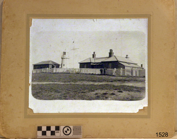
... Hill. In November 1857 the Victorian Government recommended that Warrnambool Harbour had beacons and two lighthouses to guide vessels into and out of the Harbour safely. ...Hill. In November 1857 the Victorian Government recommended that Warrnambool Harbour had beacons and two lighthouses to guide vessels into and out of the Harbour safely. ...The black and white photograph depicts the Lady Bay Lighthouse Complex at Flagstaff Hill, Warrnambool. It was opened on this site in 1871. From left to right, the Chartroom (previously named the Store), Upper Lighthouse, Flagstaff, Lighthouse Keeper's Quarters. The bluestone buildings are facing North on Merri Street. The Harbour Pilot's Lodgings were on the east of the Complex. There are two unknown male figures standing in front of the light-coloured picket fence that encompasses the Complex. The photograph is mounted on card. WARRNAMBOOL'S LADY BAY LIGHTHOUSES In the 1800s ships sailing from England to Australia began to use Bass Strait as a faster route to Melbourne. Small navigation errors led to many tragic shipwrecks. From 1848 lighthouses were operating along Victoria’s southern coast as a guide for sailors. Coastal towns such as Warrnambool grew and the exchange of trade and passengers was of great benefit. However, the uncertain weather changes, relatively shallow waters and treacherous, hidden rocky reefs were not really suitable for a Harbour and in the 1840s and 1850s, there were many shipwrecks in the area, with some even stranded in its Lady Bay harbour. A jetty was built in 1850 and a flagstaff to guide seafarers was placed up high on what became known now as Flagstaff Hill. In November 1857 the Victorian Government recommended that Warrnambool Harbour had beacons and two lighthouses to guide vessels into and out of the Harbour safely. The white light of the Middle Island lighthouse was to be used for the first time on September 1, 1859. The red light of the Beach Lighthouse, a wooden obelisk structure, was first operated on March 25, 1860, but in 1868 this light was ‘discontinued’ due to it being too low. Melbourne’s Department of Public Works decided to relocate the Middle Island Lighthouse Complex - Lighthouse, Keeper’s Quarters, Privy, Store Room and even water tanks - to Flagstaff Hill. The lower obelisk was shortened, and a protruding gallery, railing, and external ladder were added, and the light from the Beach Lighthouse. A green guiding light was erected on the end of the jetty. The transfer of the Complex began in March 1871. Each shaped stone of the lighthouse was carefully numbered, removed then reassembled on Flagstaff Hill. In 1872 the well was sunk behind the Lighthouse Keeper’s Cottage. The Keepers and families had left Middle Island in April and moved to Flagstaff Hill in October 1871. Vessels entering Lady Bay align the Upper and Lower Lighthouse towers during the day and the lights at night. The Upper Lighthouse is a round tower, and the Lower Light is square. The Lighthouses were categorised as harbour lights rather than coastal lights, so they remain under the control of the Victorian Government’s Ports and Harbours section. The lights were originally powered by oil, then acetylene gas, later by electricity, and then converted to solar power in 1988. In 1993 the solar panel was replaced by a battery charger. A decision was made in 1936 to replace the lighthouses’ lights with unattended lights that no longer required Keepers and Assistants. At least 29 Keepers had attended to the lighthouse from its opening in 1859 to when the last official Lightkeepers left In April 1916. The Warrnambool Harbour Board rented out the Quarters from 1916 to 1936. The Board closed down but the rentals continued with other unknown landlords. In the 1970s the Flagstaff Hill Planning Board was set up under the chairmanship of John Lindsay. The Board was to make recommendations to the Warrnambool City Council regarding using the buildings and the rest of the Crown Land on the site. The Flagstaff Hill Maritime Village opened in 1975 and began renovating the Cottage in stages, during which time evidence of a 1920s fire was found in the eastern section of the cottage. Additions of a porch on the west and a washroom on the east were made in the 1980s. The western part of the building is now a Shipwreck Museum and the east has returned to a late 19th-century Lighthouse Keeper’s cottage and includes the screen made by Assistant Lighthouse Keeper Thomas Hope in the late 19th century. He served as Assistant Keeper in Warrnambool for two periods.The Warrnambool Lighthouse Complex is now listed on the Victorian Heritage Register, H1520, for being of historical, scientific (technological) and architectural significance to the State of Victoria. The Complex is significant as an example of early colonial development. The buildings are significant for their connection with the important navigational function of the Lighthouses, a function still being performed to this day. The buildings are also significant as an example of structures designed and works carried out by the Public Works Department in Victoria in the mid-to-late 19th century. The structures still stand strong. Photograph; Warrnambool Lighthouse Keeper's cottage, lighthouse, flagstaff and chartroom at Flagstaff Hill, and a light-coloured picket fence with gate. Two male figures are in front of the fence. Black and white print glued to a yellow card. The inscription is indecipherable. The right side of the cottage has a built-in, enclosed addition.Ink stamped in lower right hand corner, too faded to be legible.flagstaff hill, flagstaff hill maritime museum, flagstaff hill maritime village, warrnambool, maritime museum, shipwreck coast, lighthouse keeper's cottage, lighthouse residence, lighthouse, chart room, quarters, privy, middle island, beach lighthouse, obelisk, lighthouse complex, lady bay complex, warrnambool port, warrnambool harbour, lady bay, keepers, lighthouse keeper, upper lighthouse, lower lighthouse, assistant keeper, ports and harbours, cottage, light keeper -
 Phillip Island and District Historical Society Inc.
Photographs, 1948
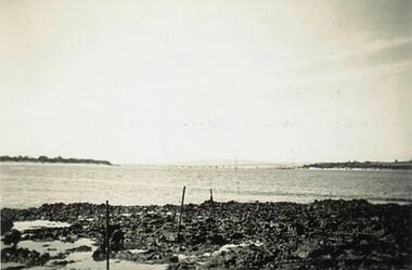
... Hills in the background. 221-02 Copy of a Postcard of the Phillip Island Granite Quarry at Cape Woolamai. Rocks in the foreground and jetty with crane on the right. An F & J Postcard. 221-03 Photograph of W Kennon's Jetty at Cape Woolamai with large rocks on the beach in the foreground. 221-04 Photograph of Mr C Richardson standing in front of a beacon at Cape Woolamai....Four photographs donated by Jim Osterlund granite quarry cape woolamai phillip island suspension bridge w kennon jetty cape woolamai c richardson cape woolamai beacon jim osterlund 221-01 Photograph of Suspension Bridge taken from Quarry area with Bass Hills in the background. 221-02 Copy of a Postcard of the Phillip Island Granite Quarry at Cape Woolamai. ...Four photographs donated by Jim Osterlund221-01 Photograph of Suspension Bridge taken from Quarry area with Bass Hills in the background. 221-02 Copy of a Postcard of the Phillip Island Granite Quarry at Cape Woolamai. Rocks in the foreground and jetty with crane on the right. An F & J Postcard. 221-03 Photograph of W Kennon's Jetty at Cape Woolamai with large rocks on the beach in the foreground. 221-04 Photograph of Mr C Richardson standing in front of a beacon at Cape Woolamai.granite quarry cape woolamai, phillip island suspension bridge, w kennon jetty cape woolamai, c richardson, cape woolamai beacon, jim osterlund -
 Flagstaff Hill Maritime Museum and Village
Equipment - EPIRB Transmitter
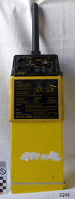
... hill-maritime-village...emergency position indicating radio beacon...beacons. This emergency location device is a late 20th century invention to help save lives at sea. It adds to the history of maritime life, its risks, the lives lost as sea, and the many inventions aimed as rescuing and saving lives. The local area is notorious for the number of lives lost through shipwreck. It also carries stories of heroic efforts to save lives, and other inventions to help reduce the chance of accidents at sea. flagstaff hill ...This distress EPIRB unit (Emergency Position Indication Radio Beacon) was found on the beach at Levy's Point, Warrnambool, in December 2000 by a Warrnambool resident. Local police were alerted at the time. This distress signal unit is a world-wide COSPAS/SARSAT, satellite assisted, SAR (Search and Rescue) system for location of distress transmissions emitted by an EPIRB. Offshore cruising vessels must have such a unit as part of its essential safety equipment. This model EPIRB relies on four satellites with orbit times of approximately 100 minutes. Earlier units relied solely on aircraft flying overhead to detect and forward on the EPIRB’s location to Search And Rescue authorities, whereas this new system utilises satellites. An employee from the Lokata firm provided additional information about the Lokata EPIRB units. They had a machined aluminium case with labels that were also made on site. The units could be activated manually or automatically released when a magnetic switch in the case casing was activated. This later model, circa 1983, would have been mounted externally on a vessel's bulkhead in a spring-loaded, stainless-steel protective 'skeleton' mounting, The unit released when the water pressure sensor detected a set time it was under the water, in a similar way that life crafts were released. Each unit was registered to a particular vessel - the vessel's details on this unit are indecipherable. The Lokata Company was established in 1970, designing and manufacturing marine products including communications. The company no longer makes products with the “Lokata” brand. In 2001 Sartech Engineering Ltd. took over the support for the Lokata EPIRB beacons. This emergency location device is a late 20th century invention to help save lives at sea. It adds to the history of maritime life, its risks, the lives lost as sea, and the many inventions aimed as rescuing and saving lives. The local area is notorious for the number of lives lost through shipwreck. It also carries stories of heroic efforts to save lives, and other inventions to help reduce the chance of accidents at sea.EPIRB unit; “Emergency Position Indication Radio Beacon”. A distress communication unit for sending a distress location transmission in an emergency at sea. The EPIRB is a yellow, rectangular box with dials, buttons, indicator lights and instruction. An antenna protrudes from the top of the unit. The EPIRB unit sends a 406P (X) EPIRB, with 406M-Hz frequency, 48-hour duration signal. The maker was LOKATA Ltd in England. Remnants of a white label remain on the side. Circa 1980s."NAME OF VESSEL 'SERVICE IF SELF TEST FAILS' " “LO-KATA” moulded into the body. "406P (X) EPIRB" “Model 406” "Lokata Type No 92408" "UK Type approved to MPT 1278" "Class 2" "Made by Lokata Ltd, Falmouth Cornwall England TR10 8AE"" "LOKATE LTD. New North Road Hainault, Ilford Essex IG6 2UR" "ARMED / SAFE / TRANSMIT / CODE / DISPLAY / SET / wait / pass / fail / TEST" "IDENTIFIER / 1349:24034234N" [some characters may be different] "COUNTRY / DENMARK" "VESSEL IDENTITY / 124 [the rest is indecipherable]flagstaff hill, warrnambool, shipwrecked-coast, flagstaff-hill, flagstaff-hill-maritime-museum, maritime-museum, shipwreck-coast, flagstaff-hill-maritime-village, emergency position indicating radio beacon, epirb, lokata ltd, marine safety equipment, satellite transmitting beacon, safety equipment, distress signal, life saving, safety at sea, shipwreck location, lo-kata, falmouth, emergency, beacon, radio signal, communication, marine equipment -
 Eltham District Historical Society Inc
Folder, Jorgensen, Sigmund
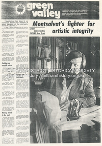
... beacon that continues to shine for the arts, Yarra Valley & Ranges Country Life (n.d.), pp46-50 (Nadine Cresswell-Myatt, Photos Zack Davis) 3. Newspaper article: Born to serve artists; former director of Montsalvat awarded medal; Patrick Phillips (Photo Robert McKechnie), Diamond Valley Leader, January 30, 2013 - awarded the Order of Australia Medal (OAM) 4. Newspaper article: Jorgensen bows out of Eltham landmark, Diamond Valley Leader, Wednesday, November 11, 2015 - former CEO of Montsalvat dropped as a director of the business 5. Newspaper article: Montsalvat, publication unknown (2006) - about Montsalvat being forced to sell off land in Christmas Hills...beacon that continues to shine for the arts, Yarra Valley & Ranges Country Life (n.d.), pp46-50 (Nadine Cresswell-Myatt, Photos Zack Davis) 3. Newspaper article: Born to serve artists; former director of Montsalvat awarded medal; Patrick Phillips (Photo Robert McKechnie), Diamond Valley Leader, January 30, 2013 - awarded the Order of Australia Medal (OAM) 4. Newspaper article: Jorgensen bows out of Eltham landmark, Diamond Valley Leader, Wednesday, November 11, 2015 - former CEO of Montsalvat dropped as a director of the business 5. Newspaper article: Montsalvat, publication unknown (2006) - about Montsalvat being forced to sell off land in Christmas Hills ...1. Newspaper article (photocopy): Montsalvat's fighter for artistic integrity, Diamond Valley News (n.d.); Story Linley Hartley, Photo: Ron Grant 2. Magazine article: The Steward: Meet the steward of Montsalvat, caretaker of his father's dream and the bohemian beacon that continues to shine for the arts, Yarra Valley & Ranges Country Life (n.d.), pp46-50 (Nadine Cresswell-Myatt, Photos Zack Davis) 3. Newspaper article: Born to serve artists; former director of Montsalvat awarded medal; Patrick Phillips (Photo Robert McKechnie), Diamond Valley Leader, January 30, 2013 - awarded the Order of Australia Medal (OAM) 4. Newspaper article: Jorgensen bows out of Eltham landmark, Diamond Valley Leader, Wednesday, November 11, 2015 - former CEO of Montsalvat dropped as a director of the business 5. Newspaper article: Montsalvat, publication unknown (2006) - about Montsalvat being forced to sell off land in Christmas Hills, where Sebastain Jorgensen lived, to pay tax debt. 6. Funeral Service Booklet: Sigmund Jorgensen, 29.04.1940 - 21.07.2109Folder of information on SigmundJorgenseneltham cemetery trust, helen skipper, justus jorgensen, matcham skipper, montsalvat, sebastian jorgensen, sigmund jorgensen, order of australia medal (oam), morag fraser, bronwyn lewis, christmas hills festival, green wedge, montsalvat trust, funeral service -
 Warrnambool and District Historical Society Inc.
Newspaper - Flagstaff Beacon, 1979
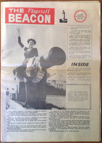
... Beacon was printed weekly from 14th July 1979 to 5th October 1979. The paper was published in Warrnambool by Trevor Alan Mackay (Ennisclay Pty Ltd) and the address was listed as 104 Liebig Street with the Classified Department at 148 Fairy Street. The name of this paper was a reference to the two operating lighthouses on Flagstaff Hill...Beacon was printed weekly from 14th July 1979 to 5th October 1979. The paper was published in Warrnambool by Trevor Alan Mackay (Ennisclay Pty Ltd) and the address was listed as 104 Liebig Street with the Classified Department at 148 Fairy Street. The name of this paper was a reference to the two operating lighthouses on Flagstaff Hill ...The Flagstaff Beacon was printed weekly from 14th July 1979 to 5th October 1979. The paper was published in Warrnambool by Trevor Alan Mackay (Ennisclay Pty Ltd) and the address was listed as 104 Liebig Street with the Classified Department at 148 Fairy Street. The name of this paper was a reference to the two operating lighthouses on Flagstaff Hill in Warrnambool. The Flagstaff Beacon was delivered free to Warrnambool householders but extra copies could be obtained for 20 cents a copy. The paper produced the usual newspaper material – current news, sport, real estate, movies, women’s news, motoring, advertisements etc. In August 1979 the Flagstaff Beacon offered colour reproductions of any photographs appearing in the paper. This was described as the first service of its kind to be offered in Victoria. These newspapers are of considerable interest as they are some of the few surviving copies of the 1979 Warrnambool paper, The Flagstaff Beacon. They also are of historical interest because of their news items and their advertisements. These are 13 copies of the Warrnambool newspaper, The Flagstaff Beacon. The newspapers are printed in black and white with a masthead featuring a colour – mainly red and orange. The masthead also has an image of a lighthouse, perhaps the Upper Lighthouse at Warrnambool. Most of the copies have 20 pages. The copies have some staining where they have been folded. warrnambool newspapers, the flagstaff beacon, history of warrnambool -
 Port Melbourne Historical & Preservation Society
Document - 1997 PMHPS Calendar, Pat Grainger, Historic Port Melbourne, Sep 1996
... Sold in Bay Street from Town Hall, Library, newsagent, Sandridge Gallery, Emerald Hill Bookstore, Sweet Port and Yorkville Kangaroo Societies Clubs Unions and other Organisations Built Environment Piers and Wharves - Railway Pier Sandridge Lagoon Beacons Arts and Entertainment - Film/Cinema Pat GRAINGER Faram Brothers Hardware PS Gem Business and Traders - Hotels 1997 calendar produced by PMH&PS, printed sepia on ivory, 16pp; cover photo 'Gem' at Railway Pier from foreshore. ...Produced by PMH&PS as a promotional/fundraising item. 500 printed, then errors discovered. Recalled, de-stapled, reprinted (8 pp), collated and redistributed. Sold in Bay Street from Town Hall, Library, newsagent, Sandridge Gallery, Emerald Hill Bookstore, Sweet Port and Yorkville Kangaroo1997 calendar produced by PMH&PS, printed sepia on ivory, 16pp; cover photo 'Gem' at Railway Pier from foreshore. Revised printing with April and May correctedsocieties clubs unions and other organisations, built environment, piers and wharves - railway pier, sandridge lagoon, beacons, arts and entertainment - film/cinema, pat grainger, faram brothers hardware, ps gem, business and traders - hotels -
 Bendigo Historical Society Inc.
Book - MERLE HALL COLLECTION: ROSALIND PARK CREATIVE VILLAGE BENDIGO PROJECT BOOK, 1995
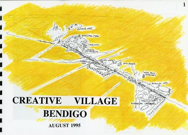
... August 1995 Book contains a description, aims of the programme and a linking plan. 35 Pages: Cover Introduction, The Design Team, Acknowledgement Project Brief Map of Linked Park The Linking Plan described Linking plan graphic Golden Beacon Design Concept Bridge Beacon Entrance to Linear Park Gasworks Café Pavillion Gasworks layout plan Golden Beacons Concept Botanical Gardens Café Botanical Gardens layout plan Victoria Hill Interpretation Centre Victoria Hill layout Victoria Hill plan Victoria Hill continued Victoria Hill continued Rosalind Park Lookout Method 3D Road Map 3D Road Map Continued Implementation Community Participation Opportunities, Mosaic Works Appropriate sites Appropriate sites continued Consultation Summary and Issues Ideas Areas for further consideration Graphic The Design Team - Grant Fink, Jane Marriott, Laszo Biro, James Brearley Graphic Layout...August 1995 Book contains a description, aims of the programme and a linking plan. 35 Pages: Cover Introduction, The Design Team, Acknowledgement Project Brief Map of Linked Park The Linking Plan described Linking plan graphic Golden Beacon Design Concept Bridge Beacon Entrance to Linear Park Gasworks Café Pavillion Gasworks layout plan Golden Beacons Concept Botanical Gardens Café Botanical Gardens layout plan Victoria Hill Interpretation Centre Victoria Hill layout Victoria Hill plan Victoria Hill continued Victoria Hill continued Rosalind Park Lookout Method 3D Road Map 3D Road Map Continued Implementation Community Participation Opportunities, Mosaic Works Appropriate sites Appropriate sites continued Consultation Summary and Issues Ideas Areas for further consideration Graphic The Design Team - Grant Fink, Jane Marriott, Laszo Biro, James Brearley Graphic Layout Book MERLE HALL COLLECTION: ROSALIND PARK CREATIVE VILLAGE BENDIGO PROJECT BOOK ...Merle Hall Collection: Rosalind Park Creative Village Bendigo Project Book. August 1995 Book contains a description, aims of the programme and a linking plan. 35 Pages: Cover Introduction, The Design Team, Acknowledgement Project Brief Map of Linked Park The Linking Plan described Linking plan graphic Golden Beacon Design Concept Bridge Beacon Entrance to Linear Park Gasworks Café Pavillion Gasworks layout plan Golden Beacons Concept Botanical Gardens Café Botanical Gardens layout plan Victoria Hill Interpretation Centre Victoria Hill layout Victoria Hill plan Victoria Hill continued Victoria Hill continued Rosalind Park Lookout Method 3D Road Map 3D Road Map Continued Implementation Community Participation Opportunities, Mosaic Works Appropriate sites Appropriate sites continued Consultation Summary and Issues Ideas Areas for further consideration Graphic The Design Team - Grant Fink, Jane Marriott, Laszo Biro, James Brearley Graphic Layoutbook, bendigo creative village -
Port Melbourne Historical & Preservation Society
Map - Photographic copy, Unidentified map of Sandridge, c. 1866
... Piers and Wharves Transport - Railways Built Environment Maritime Beacons Sandridge Lagoon Batteries - Defensive Commander COX Fold lines have been whited out on back; '52' Photographic copy of an unidentified (Cox?) Sandridge map 1866 or later, with portions of West Melbourne, Emerald Hill and the Bend. ...Photographic copy of an unidentified (Cox?) Sandridge map 1866 or later, with portions of West Melbourne, Emerald Hill and the Bend. Indicates bay and river soundings 'taken by Commander COX in 1866'. Original appears to have been torn and repaired; resultant lines whited out on copy.Fold lines have been whited out on back; '52'piers and wharves, transport - railways, built environment, maritime, beacons, sandridge lagoon, batteries - defensive, commander cox -
Port Melbourne Historical & Preservation Society
Document - Exhibition Catalogue, Joan Winter, Dredging, Draining, Dipping & Shipping: A History of the Foreshore & Low-lying Lands of the City of Port Phillip, Apr 1996
... Sandridge Lagoon Engineering - Canals and Drainage Melbourne Harbor Trust - Port of Melbourne Authority Piers and Wharves Piers and Wharves - Waterside Workers Arts and Entertainment Transport - Shipping Centenary Bridge Beacons Fishermans Bend Transport - Aviation and Aerodrome Sport - Swimming Flood Local Government - City of Port Phillip Kulin Nation Caroline Frederica LIARDET Swallow & Ariell Ltd Mission to Seafarers Emerald Hill St Kilda First major exhibition from the Council of Port Phillip was held in 1995. ...First major exhibition from the Council of Port Phillip was held in 1995. The catalogue material on Port Melbourne was written by PMH&PS members. It toured the city and then a reduced version was sent to sister city, Devonport. Black text and picture of Sandridge from the Esplanade, St Kilda on cover. sandridge lagoon, engineering - canals and drainage, melbourne harbor trust - port of melbourne authority, piers and wharves, piers and wharves - waterside workers, arts and entertainment, transport - shipping, centenary bridge, beacons, fishermans bend, transport - aviation and aerodrome, sport - swimming, flood, local government - city of port phillip, kulin nation, caroline frederica liardet, swallow & ariell ltd, mission to seafarers, emerald hill, st kilda -
 Narre Warren and District Family History Group
Book, Narre Warren & District Family History Group Inc, Casey Cardinia Collection - Selected articles from the West Gippsland Trader - Volume 1, 2010
... Hills - Tall Story or Truth? 18 Apr ? Interesting Times 15 Aug 2013 Remembering the Good Times 11 Dec 2014 The Old Sale Road - an Important Link 26 Mar 2015 Difficult to Know the Real Story 27 Nov 2014 The State’s Real Birthday 12 Sep 2013 The Herald 1925 2 Oct 2014 Beacons of Hope 9 Oct 2014 The Joys of Parenthood 6 Nov 2014 Aboriginal Life in Gippsland 30 Oct 2014 Growing up in Gippsland - Harriett Quigley 26 Sep 2013 The McHaffie Diary 19 Sep 2013 Outtrim - Once a Boom Town 10 Oct 2013 Happy Hundredth Birthday 4 Sep 2014 Many Towns Simply Disappeared 17 Jul 2014 Long Distance Farmer 25 Sep 2014 Sam Anderson - Gippsland’s First Farmer 28 Aug 2014 Local Oil 90 Years Ago 6 Mar 2014 A Fiery Summer - 1898 20 Feb 2014 The Corduroy Roads 8 May 2014 The Darkness Within 13 Mar ? ...Hills - Tall Story or Truth? 18 Apr ? Interesting Times 15 Aug 2013 Remembering the Good Times 11 Dec 2014 The Old Sale Road - an Important Link 26 Mar 2015 Difficult to Know the Real Story 27 Nov 2014 The State’s Real Birthday 12 Sep 2013 The Herald 1925 2 Oct 2014 Beacons of Hope 9 Oct 2014 The Joys of Parenthood 6 Nov 2014 Aboriginal Life in Gippsland 30 Oct 2014 Growing up in Gippsland - Harriett Quigley 26 Sep 2013 The McHaffie Diary 19 Sep 2013 Outtrim - Once a Boom Town 10 Oct 2013 Happy Hundredth Birthday 4 Sep 2014 Many Towns Simply Disappeared 17 Jul 2014 Long Distance Farmer 25 Sep 2014 Sam Anderson - Gippsland’s First Farmer 28 Aug 2014 Local Oil 90 Years Ago 6 Mar 2014 A Fiery Summer - 1898 20 Feb 2014 The Corduroy Roads 8 May 2014 The Darkness Within 13 Mar ? ...Folder containing a table of contents and a selection of articles on Gippsland History by John Wells in the West Gippsland Trader Volume 1. The date the articles were published, and title of articles are listed below. 30 Oct 1997 Noojee Railway Line is an Engineering Classic 06 Nov 1997 Railways were a kiss of life for small settlements 13 Nov 1997 Erica was a timber and railway town 20 Nov 1997 People fought for railway line through to Stratford 27 Nov 1997 Tiny towns on the Wonthaggi line Vol 16 No 50 Cobungra station has some wild and beautiful country Vol 16 No 51 The explorers we have forgotten Vol 17 No 30 Hallam store became a place for men to gather 14 Feb 2002 Charlie Styles and his dull grey bedford bus Vol 26 No 10 Southern Community names 03 Aug 2006 A bit more Cloverlea 28 Sep 2006 Many airlines were keen to link wide brown land 26 Oct 2006 The ‘run’ at Top Plain 02 Nov 2006 Briagolong and the Garden of Eden 09 Nov 2006 I found a treasure in a milk bar 16 Nov 2006 Got five bob in your pocket, or should I say fifty cents? 23 Nov 2006 Trains were important in developing Gippsland 30 Nov 2006 The main line into Gippsland 07 Dec 2006 Alfred Howitt was a great man who deserves recognition Dec 2006? Christmas again? Already? 15 Feb 2007 The Great Southern Railway 08 Mar 2007 Expectations about water quality have changed since the old days 29 Mar 2007 Navigating by tree tops 12 Apr 2007 The Gippsland railway branch lines were very important in many ways 26 Apr 2007 Some community names from our northern hills 10 May 2007 Community names at the eastern end 24 May 2007 A shorter railway with big tonnages 31 May 2007 Cerberus was the guard dog 07 Jun 2007 Suburban stations in Gippsland 14 Jun 2007 How many Longwarry schools were there? 21 Jun 2007 Traralgon run was Hobson’s choice 28 Jun 2007 Maiden and Mormon and Happy Go Lucky 05 Jul 2007 Consider the humble rabbit trap 12 Jul 2007 Five acre blocks are everywhere 26 Jul 2007 Fencing, but not the Olympic variety 02 Aug 2007 Hanging the barbed wire fences 09 Aug 2007 Collecting and keeping the tucker we gathered 23 Aug 2007 The Longwarry Primary School itself 30 Aug 2007 Surveyors did it hard down Poowong way 06 Sep 2007 Back to the Poowong story 13 Sep 2007 A “think piece” or an indulgence? 20 Sep 2007 Longwarry “extra late final” 04 Oct 2007 Platina’s gone but not forgotten 11 Oct 2007 Robert Nield – Murray is back at it 18 Oct 2007 Spetts’ cottage at Walhalla 25 Oct 2007 Across the Alps to Omeo 08 Nov 2007 Where the gold lies deep in settlements that died 15 Nov 2007 Mines aplenty in the Walhalla area 22 Nov 2007 The other Violet Town – Jolly’s 29 Nov 2007 Mallacoota archaeology 06 Dec 2007 The Cassilis township or call it a settlement 13 Dec 2007 George Bass missed French Island 08 Feb 2008 David Mickle relates many stories of railway accidents 11Sep 2008 Lord Howe has a long history 18 Sep 2008 Quarry Hills important link for Berwick 25 Sep 2008 Tall ships, short ships, schooners and sloops 26 Jun 2008 We find Yanakie Jack again 03 Jul 2008 The well known Baw Baw Track 10 Jul 2008 Land of the moon? 07 Aug 2008 I loved eeling in the Tarago River 14 Aug 2008 Don’t let the red steer loose 28 Aug 2008 Yes, there is a place called Jumbuk 04 Sep 2008 The land of the big trees 23 Oct 2008 Still looking for Gippsland’s first town 13 Nov 2008 Journey to the bowels of the earth 30 Oct 2008 For King and Country – J.M. Laidlaw 06 Nov 2008 Jesse Huggett lived an adventurous life 22 Nov 2008 Churchill Island, yet again 04 Dec 2008 Bowman’s Track – if we can find it 11 Dec 2008 Draining of the great Koo Wee Rup Swamp 18 Dec 2008 The swampies had a go 02 Apr 2009 Looking for natural gas not offshore oil 21 Aug 2008 The Dreaded Summer Wildfire 17 Jul 2008 The Tangel (or Tanjil) hills District 7 Feb 2012 The Tanjil Area Goldrush 29 Aug 2013 Saddled and Spurred 9 Feb 2012 Many Racecourses Have Disappeared 16 Feb 2012 Fraser’s Hotel in Glenmaggie 23 Feb 2012 “Nothing Today, Jack!” on the Berwick Hill 1 Mar 2012 The Schnapper Point Line 8 Mar 2012 The Imaginary Town of Tambo 22 Mar 2012 The Tanjil Story Part One 15 Mar 2012 Inverloch Served Mosquito Fleet of Mis-Matched Boats 21 Jun 2012 The Last Bits of the Line 29 Mar 2012 “Gold Rush” to the Tanjil Area led to Reef Mining Companies 16 Aug 2012 New Life for Old Port Welshpool? 30 Aug 2012 The Capital of South Gippsland 28 Jun 2012 The Last Bits of the Line 5 Jul 2012 Ferdinand Von Mueller - a Man of Knowledge 12 Jul 2012 Stones in the Creek 19 Jul 2012 Gembrook - an Attractive Little Town 7 Jun 2012 Getting Rid of the Wood 21 Mar 2013 Getting Into Orbost 13 Dec ? Metung - A BEnd in the River 20 Sep 2012 The Royal Victorian Navy 6 Dec 2012 Tree Ferns to Blackberries 22 Nov 2012 Nowa Nowa Arm and Boggy Creek 18 Oct 2012 Home of the Baw Baw Frog 1 Nov 2012 Clearing the Hills 11 Oct 2012 The Loss of the Monumental City 4 Oct 2012 The Waterloo Township 13 Sep 2012 Birth of the Shire of Morwell 27 Sep 2012 George Black and Tarwin Meadows 9 Aug 2012 The Forgotten Corner of Gippsland 27 Mar 2008 Thomas William Harrison’s Family 3 Jul ? Railway was Enormous Value to Swamp Country 19 Jun 2008 The Narre Warren Reserve Gates 12 Jun 2008 Heavy Harry is a Pretty Crook Giant 2 May ? Small Settlements on a Long Gippsland Track 5 Jun 2008 Land of Bullumwaal ot “Two Spears” 29 May 2008 Bigger Stops on a Long Road 15 May 2008 Crossing the Beautiful Snowy River 17 Apr 2008 I Remember Uncle Jack aqs an Old Man with Something Wrong 25 Jun 2009 The Murder of Cornelius Green 2 Jul 2009 Captain James Cook was too Late 5 Sep 2013 Oil and the Gippsland Lakes 18 Jun 2009 The Suburbs Around Sale 13 May 2010 The Boag Generations go on and on in Gippsland 27 May 2010 Underwater Coal at Yallourn Open Cut 4 Nov 2010 Narracan - the Aboriginal Name for Crow 23 Apr 2009 Driving Along the Omeo Track 2 Dec 2010 Remembering Those Old Wives’ Tales that we all Grew up with 16 Apr 2009 Myrtlebank, the Lost Suburb 16 Dec 2010 The Tragedy of the Loch Ard 9 Dec 2010 The Latrobe River Wharf on the East Bank 2 Jun 2011 Stony Creek Township’s Quiet Past 17 Mar 2011 William Barak Saw the Whites Take Over 5 May 2011 The Squatters’ Names Still Here 12 May 2011 The Diary of C.A.Ramsden (part one) 26 May 2011 South Coast Towns, 1891 19 May 2011 The Second Part of C.A.Ramsden’s Diary 28 Apr 2011 Squatter Names Still Remain on our Maps 13 Oct 2011 The Resting Place of 1131 Australians 29 Sep 2011 The Mitchell Valley Hopfields Oct 6 Lest We Forget - Lijssenthoek 10 Nov 2011 The Kurnai Men UNKNOWN The Returning of Captain Joe McLaughlin 6 Jun 2013 The Marlo Plains 16 May 2013 Bain’s Border Hotel 23 May ? The Mystery Map 30 May 2013 Finding a Road to the Jordan 4 Apr 2013 Rick Solves Mystery of American Captain 2 May ? The Haunted Hills - Tall Story or Truth? 18 Apr ? Interesting Times 15 Aug 2013 Remembering the Good Times 11 Dec 2014 The Old Sale Road - an Important Link 26 Mar 2015 Difficult to Know the Real Story 27 Nov 2014 The State’s Real Birthday 12 Sep 2013 The Herald 1925 2 Oct 2014 Beacons of Hope 9 Oct 2014 The Joys of Parenthood 6 Nov 2014 Aboriginal Life in Gippsland 30 Oct 2014 Growing up in Gippsland - Harriett Quigley 26 Sep 2013 The McHaffie Diary 19 Sep 2013 Outtrim - Once a Boom Town 10 Oct 2013 Happy Hundredth Birthday 4 Sep 2014 Many Towns Simply Disappeared 17 Jul 2014 Long Distance Farmer 25 Sep 2014 Sam Anderson - Gippsland’s First Farmer 28 Aug 2014 Local Oil 90 Years Ago 6 Mar 2014 A Fiery Summer - 1898 20 Feb 2014 The Corduroy Roads 8 May 2014 The Darkness Within 13 Mar ? Draining the Moe Swamp 1 May 2014 Any Ideas on Old Cannon? 3 Jul 2014 The Magnificent Snowy 14 Aug 2014 Two Gems in the Hills 19 Jun 2014 The Towns Down the Line 27 Feb 2014 State School 2502, Longwarry 18 Sep 2014 Lakes a Natural Fishing Ground 15 May 2014 Police Down the Ages 22May 2014 Iron Horse Came at a Walk 29 May 2014 Prom’s Early Attraction 12 Jun 2014 A Brief History of Meeniyan 5 Jun 2014 Ride on the Old Great Southern 26 Jun 2014 When Victoria Police Went on Strike 23 Apr 2015 Grandma’s Family Lost Heavily 11 Jun 2015 A Rail Journey Almost to Orbost 28 May 2015 Second Battle of Hastings 4 Jun 2015 Dandenong to Trafalgar by Train 18 Jun 2015 The Travelling Picture Man 19 Feb 2015 Water was a Problem 5 Feb 2015 Sandy Point Return Invokes Memories 24 Oct 2013 Lyrebirds Nesting in Trees? 12 Mar 2015 Supplying Melbourne’s Water 9 Aug 2015 They Shall Not Grow Old as we That Are Left 9 Jul 2015 National Parks a Valuable Resource 11 Sep 2014 Living Through the Best and the Worst 12 Feb 2015 Fishing is Part of Port’s History 26 Feb 2015 Chance Lost to Eliminate Rabbits 5 Mar 2015 Bloomfield - End of the Line, in a Way 11 Jul ? Emerald Primary School 22 Aug 2013 The Heartbreak Hills 17 Oct 2013 Port Albert, Land of Elephants 14 Nov 2013 Bullumwaal Land of Two Spears 28 Nov 2013 Coalville - the Forgotten Mine 5 Dec 2013 Early Travel with the Bishop 12 Dec 2013 Bishop Perry in Gippsland 19 Dec 2013 The Great Sale Goldfields Hoax 20 Mar 2014 A Chance to Dazzle the Kids 27 Mar 2014 More of Those Creeks and Rivers 3 Apr 2014 The Arctocephalus is With us Still 10 Apr 2014 Upper Yarra Dam had an Early Start UNKNOWN Harkaway’s Colorful History Contains Some Doubtful Tales UNKNOWN Berwick and the Peninsula in 1886non-fictionwonthaggi railway line towns, great southern railway, baw baw track -
 Narre Warren and District Family History Group
Book, Narre Warren & District Family History Group Inc, Casey Cardinia Collection - Selected articles from the West Gippsland Trader - Volume 2, 2021
... Hills - Tall Story or Truth? 18 Apr ? Interesting Times 15 Aug 2013 Remembering the Good Times 11 Dec 2014 The Old Sale Road - an Important Link 26 Mar 2015 Difficult to Know the Real Story 27 Nov 2014 The State’s Real Birthday 12 Sep 2013 The Herald 1925 2 Oct 2014 Beacons of Hope 9 Oct 2014 The Joys of Parenthood 6 Nov 2014 Aboriginal Life in Gippsland 30 Oct 2014 Growing up in Gippsland - Harriett Quigley 26 Sep 2013 The McHaffie Diary 19 Sep 2013 Outtrim - Once a Boom Town 10 Oct 2013 Happy Hundredth Birthday 4 Sep 2014 Many Towns Simply Disappeared 17 Jul 2014 Long Distance Farmer 25 Sep 2014 Sam Anderson - Gippsland’s First Farmer 28 Aug 2014 Local Oil 90 Years Ago 6 Mar 2014 A Fiery Summer - 1898 20 Feb 2014 The Corduroy Roads 8 May 2014 The Darkness Within 13 Mar ? ...Hills - Tall Story or Truth? 18 Apr ? Interesting Times 15 Aug 2013 Remembering the Good Times 11 Dec 2014 The Old Sale Road - an Important Link 26 Mar 2015 Difficult to Know the Real Story 27 Nov 2014 The State’s Real Birthday 12 Sep 2013 The Herald 1925 2 Oct 2014 Beacons of Hope 9 Oct 2014 The Joys of Parenthood 6 Nov 2014 Aboriginal Life in Gippsland 30 Oct 2014 Growing up in Gippsland - Harriett Quigley 26 Sep 2013 The McHaffie Diary 19 Sep 2013 Outtrim - Once a Boom Town 10 Oct 2013 Happy Hundredth Birthday 4 Sep 2014 Many Towns Simply Disappeared 17 Jul 2014 Long Distance Farmer 25 Sep 2014 Sam Anderson - Gippsland’s First Farmer 28 Aug 2014 Local Oil 90 Years Ago 6 Mar 2014 A Fiery Summer - 1898 20 Feb 2014 The Corduroy Roads 8 May 2014 The Darkness Within 13 Mar ? ...Folder containing a table of contents and a selection of articles on Gippsland History by John Wells in the West Gippsland Trader Volume 2. The date the articles were published, and title of articles are listed below. 19 Jul 2012 Gembrook - an Attractive Little Town 7 Jun 2012 Getting Rid of the Wood 21 Mar 2013 Getting Into Orbost 13 Dec ? Metung - A BEnd in the River 20 Sep 2012 The Royal Victorian Navy 6 Dec 2012 Tree Ferns to Blackberries 22 Nov 2012 Nowa Nowa Arm and Boggy Creek 18 Oct 2012 Home of the Baw Baw Frog 1 Nov 2012 Clearing the Hills 11 Oct 2012 The Loss of the Monumental City 4 Oct 2012 The Waterloo Township 13 Sep 2012 Birth of the Shire of Morwell 27 Sep 2012 George Black and Tarwin Meadows 9 Aug 2012 The Forgotten Corner of Gippsland 27 Mar 2008 Thomas William Harrison’s Family 3 Jul ? Railway was Enormous Value to Swamp Country 19 Jun 2008 The Narre Warren Reserve Gates 12 Jun 2008 Heavy Harry is a Pretty Crook Giant 2 May ? Small Settlements on a Long Gippsland Track 5 Jun 2008 Land of Bullumwaal ot “Two Spears” 29 May 2008 Bigger Stops on a Long Road 15 May 2008 Crossing the Beautiful Snowy River 17 Apr 2008 I Remember Uncle Jack aqs an Old Man with Something Wrong 25 Jun 2009 The Murder of Cornelius Green 2 Jul 2009 Captain James Cook was too Late 5 Sep 2013 Oil and the Gippsland Lakes 18 Jun 2009 The Suburbs Around Sale 13 May 2010 The Boag Generations go on and on in Gippsland 27 May 2010 Underwater Coal at Yallourn Open Cut 4 Nov 2010 Narracan - the Aboriginal Name for Crow 23 Apr 2009 Driving Along the Omeo Track 2 Dec 2010 Remembering Those Old Wives’ Tales that we all Grew up with 16 Apr 2009 Myrtlebank, the Lost Suburb 16 Dec 2010 The Tragedy of the Loch Ard 9 Dec 2010 The Latrobe River Wharf on the East Bank 2 Jun 2011 Stony Creek Township’s Quiet Past 17 Mar 2011 William Barak Saw the Whites Take Over 5 May 2011 The Squatters’ Names Still Here 12 May 2011 The Diary of C.A.Ramsden (part one) 26 May 2011 South Coast Towns, 1891 19 May 2011 The Second Part of C.A.Ramsden’s Diary 28 Apr 2011 Squatter Names Still Remain on our Maps 13 Oct 2011 The Resting Place of 1131 Australians 29 Sep 2011 The Mitchell Valley Hopfields Oct 6 Lest We Forget - Lijssenthoek 10 Nov 2011 The Kurnai Men UNKNOWN The Returning of Captain Joe McLaughlin 6 Jun 2013 The Marlo Plains 16 May 2013 Bain’s Border Hotel 23 May ? The Mystery Map 30 May 2013 Finding a Road to the Jordan 4 Apr 2013 Rick Solves Mystery of American Captain 2 May ? The Haunted Hills - Tall Story or Truth? 18 Apr ? Interesting Times 15 Aug 2013 Remembering the Good Times 11 Dec 2014 The Old Sale Road - an Important Link 26 Mar 2015 Difficult to Know the Real Story 27 Nov 2014 The State’s Real Birthday 12 Sep 2013 The Herald 1925 2 Oct 2014 Beacons of Hope 9 Oct 2014 The Joys of Parenthood 6 Nov 2014 Aboriginal Life in Gippsland 30 Oct 2014 Growing up in Gippsland - Harriett Quigley 26 Sep 2013 The McHaffie Diary 19 Sep 2013 Outtrim - Once a Boom Town 10 Oct 2013 Happy Hundredth Birthday 4 Sep 2014 Many Towns Simply Disappeared 17 Jul 2014 Long Distance Farmer 25 Sep 2014 Sam Anderson - Gippsland’s First Farmer 28 Aug 2014 Local Oil 90 Years Ago 6 Mar 2014 A Fiery Summer - 1898 20 Feb 2014 The Corduroy Roads 8 May 2014 The Darkness Within 13 Mar ? Draining the Moe Swamp 1 May 2014 Any Ideas on Old Cannon? 3 Jul 2014 The Magnificent Snowy 14 Aug 2014 Two Gems in the Hills 19 Jun 2014 The Towns Down the Line 27 Feb 2014 State School 2502, Longwarry 18 Sep 2014 Lakes a Natural Fishing Ground 15 May 2014 Police Down the Ages 22May 2014 Iron Horse Came at a Walk 29 May 2014 Prom’s Early Attraction 12 Jun 2014 A Brief History of Meeniyan 5 Jun 2014 Ride on the Old Great Southern 26 Jun 2014 When Victoria Police Went on Strike 23 Apr 2015 Grandma’s Family Lost Heavily 11 Jun 2015 A Rail Journey Almost to Orbost 28 May 2015 Second Battle of Hastings 4 Jun 2015 Dandenong to Trafalgar by Train 18 Jun 2015 The Travelling Picture Man 19 Feb 2015 Water was a Problem 5 Feb 2015 Sandy Point Return Invokes Memories 24 Oct 2013 Lyrebirds Nesting in Trees? 12 Mar 2015 Supplying Melbourne’s Water 9 Aug 2015 They Shall Not Grow Old as we That Are Left 9 Jul 2015 National Parks a Valuable Resource 11 Sep 2014 Living Through the Best and the Worst 12 Feb 2015 Fishing is Part of Port’s History 26 Feb 2015 Chance Lost to Eliminate Rabbits 5 Mar 2015 Bloomfield - End of the Line, in a Way 11 Jul ? Emerald Primary School 22 Aug 2013 The Heartbreak Hills 17 Oct 2013 Port Albert, Land of Elephants 14 Nov 2013 Bullumwaal Land of Two Spears 28 Nov 2013 Coalville - the Forgotten Mine 5 Dec 2013 Early Travel with the Bishop 12 Dec 2013 Bishop Perry in Gippsland 19 Dec 2013 The Great Sale Goldfields Hoax 20 Mar 2014 A Chance to Dazzle the Kids 27 Mar 2014 More of Those Creeks and Rivers 3 Apr 2014 The Arctocephalus is With us Still 10 Apr 2014 Upper Yarra Dam had an Early Start UNKNOWN Harkaway’s Colorful History Contains Some Doubtful Tales UNKNOWN Berwick and the Peninsula in 1886non-fictiongippsland lakes, emerald primary school, meeniyan, upper yarra dam -
 Bendigo Military Museum
Photograph - Royal Australian Survey Corps - Map Production Processes, c1990
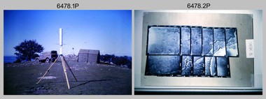
... Geodetic Surveying: AN/PRR-14 Geoceiver antenna on hill surrounding Lake Hume. Series 3 Land Rover, field party tent and survey station beacon in background. .2) – Photo, black & white, c1980s. ...Geodetic Surveying: AN/PRR-14 Geoceiver antenna on hill surrounding Lake Hume. Series 3 Land Rover, field party tent and survey station beacon in background. .2) – Photo, black & white, c1980s. ...This is a collection of 20 photographs of Royal Australian Survey Corps phases of map production at the School of Military Survey, Bonegilla, the Army Survey Regiment, Bendigo, and the Army Map Depot, Bandiana circa 1990. Colour photos are on 35mm slide film and were scanned at 96 dpi. They are part of the Army Survey Regiment’s Collection. Photo .1P was probably taken on a survey station overlooking Lake Hume near Albury-Wodonga. The field party occupying the survey station was likely from a Map Control Survey course conducted by the School of Military Survey, Bonegilla. This survey station was part of a geodetic network used in field survey training and RASvy’s Lake Hume Test Range. Photos .3P to .16P were taken at the Army Survey Regiment, Bendigo and photos .17P & .18P were taken at the Army Map Depot, Bandiana. Photo .19P depicts a map of RASvy’s ARA units before the disbandment of 5th Field Survey Squadron, Perth and 2nd Field Survey Squadron, Sydney in 1990. This is a collection of 20 photographs of map production processes taken at the School of Military Survey, Bonegilla, the Army Survey Regiment, Bendigo, and the Army Map Depot, Bandiana circa 1990. Colour photos are on 35mm slide film and were scanned at 96 dpi. They are part of the Army Survey Regiment’s Collection. Photo .2P is printed on photographic and scanned at 300 dpi. .1) – Photo, colour, c1980s. Geodetic Surveying: AN/PRR-14 Geoceiver antenna on hill surrounding Lake Hume. Series 3 Land Rover, field party tent and survey station beacon in background. .2) – Photo, black & white, c1980s. Geodetic Surveying: AN/PRR-14 Geoceiver antennas set up at the School of Military Survey, Bonegilla, Victoria. .3) – Photo, colour, c1990. Aerotriangulation: Wild PUG4 point transfer device, SSGT Bruce Hammond. .4) – Photo, colour, c1990. Aerotriangulation: Zeiss (Jena) Stecometer, SSGT Bruce Hammond. .5) – Photo, colour, c1990. Aerotriangulation: computer tape maintenance, SSGT Noel McNamara. .6) – Photo, colour, c1990. AUTOMAP 2: computer tape maintenance, SPR Nadine (Paul) Read. .7) - Photo, colour, c1990s. AUTOMAP 2: Optronics 4040 scanning/film output in Lithographic Squadron, SGT Sherri (Dally) Burke. .8) - Photo, colour, c1990s. AUTOMAP 2: Benson verification plotter output, SPR Nadine (Paul) Read. .9) – Photo, colour, c1990. Aerotriangulation: data management, SGT Neil ‘Ned’ Kelly. .10) & .11) - Photo, colour, c1990s. AUTOMAP 2: Wild B8 Aviograph stereoplotter Feature Extraction, unidentified technician. .12) - Photo, colour, c1990s. AUTOMAP 2: Graphic Edit Workstation, SPR Nadine (Paul) Read. .13) - Photo, colour, c1990s. AUTOMAP 2: Graphic Edit Workstation, SPR Dawn Hoadley. .14) & .15) - Photo, colour, c1990s. AUTOMAP 2: Graphic Edit Workstation, unidentified technician. .16) – Photo, colour, c1990s. Heidelberg Speedmaster 102 computer-controlled five colour lithographic offset printing press. .17) & .18) – Photo, colour, c1990s. Army Map Depot, unidentified storeman, Bandiana. .19) – Photo, colour, c1990. RASvy ARA Unit Locations before disbandment of field units in Perth and Sydney. .20) – Photo, colour, c1990. Set of overlapping aerial photography..1P, .3P to .20P - Some equipment is identified on the frame of the 35mm slides.royal australian survey corps, rasvy, army survey regiment, army svy regt, fortuna, asr, school of military survey, army map depot
