Showing 25 items matching "bellevue road"
-
 Eltham District Historical Society Inc
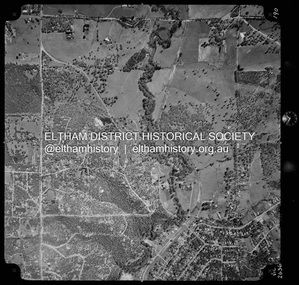
Photograph - Aerial Photograph, Landata, Eltham North, Vic, Apr. 1972
... ...Bellevue Road...Centred on present day Eltham North reserve near Eltham North Primary School, Eltham North bounded by Allendale Road to north, Bellevue Road to south, Zig Zag Road and Beard Street to east and Ryans Road to west. ...Eltham District Historical Society Inc 728 Main Rd Eltham melbourne Centred on present day Eltham North reserve near Eltham North Primary School, Eltham North bounded by Allendale Road to north, Bellevue Road to south, Zig Zag Road and Beard Street to east and Ryans Road to west. ...Centred on present day Eltham North reserve near Eltham North Primary School, Eltham North bounded by Allendale Road to north, Bellevue Road to south, Zig Zag Road and Beard Street to east and Ryans Road to west. Historic Aerial Imagery Source: Landata.vic.gov.au Aerial Photo Details: Project No :985 Project : MELBOURNE 1972 Run : 26 Frame : 190 Date : 04/1972 Film Type : B/W Camera : RC10 Flying Height : 5700 Scale : 9600 Film Number : 2636 GDA2020 : 37°41'52"S, 145°08'52"E MGA2020 : 336705, 5826102 (55) Melways : 11 J12 (ed. 42)aerial photo, neil webster collection, 1972-04, allendale road, beard street, bellevue road, eltham, eltham north, eltham north reserve, melway 11j12, ryans road, zig zag road, eltham north primary school -
 Bendigo Historical Society Inc.
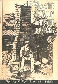
Document - PURDY COLLECTION: VALLEY OF THE SPRINGS
... Written on front in biro 'J.B. Purdy, 49 Bellevue Road, Golden Square. ...History House 11 Mackenzie Street Bendigo goldfields BENDIGO History spring gully Written on front in biro 'J.B. Purdy, 49 Bellevue Road, Golden Square. Booklet: 'The Valley of the Springs' a booklet produced to celebrate Spring Gully's First 127 Years. ...Booklet: 'The Valley of the Springs' a booklet produced to celebrate Spring Gully's First 127 Years. Contains poem about Spring Gully by J.C. Hattam, Photos: St. Phillips Spring Gully, choir practice; garden party to raise funds for St. Phillips, taken on Keck's verandah, Abbotts Tannery, Tannery Lane, school photos, opening of tower on One Tree Hill, a mine at Diamond Hill (un-named) horse drawn vehicles, wood carter, Spring Gully reservoir being enlarged. Written on front in biro 'J.B. Purdy, 49 Bellevue Road, Golden Square. bendigo, history, spring gully -
 Bendigo Historical Society Inc.
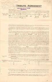
Document - MCCOLL, RANKIN AND STANISTREET COLLECTION: DEBORAH MINES NL - TRIBUTE AGREEMENT, 1934
... Castle, Adams Road. A. Randall, Bellevue Road, L. Watt, Allingham Street, Joseph Hocking, Bellevue Road, Golden Square, Allan Randall, Bellevue Road, Golden Square....Castle, Adams Road. A. Randall, Bellevue Road, L. Watt, Allingham Street, Joseph Hocking, Bellevue Road, Golden Square, Allan Randall, Bellevue Road, Golden Square. ...Document: McColl, Rankin and Stanistreet: Deborah Gold Mine NL 4 copies of tribute agreements Foolscap document, agreements made between Deborah Gold Mines NL and P. Flanagan, 6 Bancroft Street, Bendigo, D. McMahon 109 Olinda Street, Bendigo, L. Balle and L. Castle, Adams Road. A. Randall, Bellevue Road, L. Watt, Allingham Street, Joseph Hocking, Bellevue Road, Golden Square, Allan Randall, Bellevue Road, Golden Square.organization, mining, deborah gold mine nl tribute mining, mccoll, rankin and stanistreet: deborah gold mine nl, goldmining, mining, tribute mining -
 Eltham District Historical Society Inc
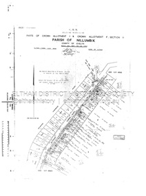
Document - Survey Plan, Country Roads Board, SP 6561, Eltham-Yarra Glen Road; Park Rd to Bellevue Rd, 1957
... SP 6561, Eltham-Yarra Glen Road; Park Rd to Bellevue Rd......Bellevue Road...Hearn B.G. Anderson Bellevue Road E.M. Pitts F.A. M. Macrae G.E. & B. ...1957 C.R.B. Plan of Survey of Parts of Crown Allotment 1 & Crown Allotment F, Section II Parish of Nillumbik, County of Evelyn Eltham-Yarra Glen Road, Shire of Eltham Shows Surveyor field notes, property ownership and building type and construction.eltham-yarra glen road, country roads board, eltham, main road, survey plan, 1957, a.r. thomas, b. & b.d. hearn, b.g. anderson, bellevue road, e.m. pitts, f.a. m. macrae, g.e. & b. moulder, j. bromley, j.m. & s.g. johnstone, k.f. pitts, l.c. docksey, m. & e.c.w. baart, m.p. bromley, n.r. ord, p.j. & g.e. murphy, park road, r.a. bruce, r.a. macbeth, r.w. shearing, railway road, s.e. & y.p. houghton, w.k. bell, w.s.r. & f.n. toley, neil webster collection -
 Eltham District Historical Society Inc
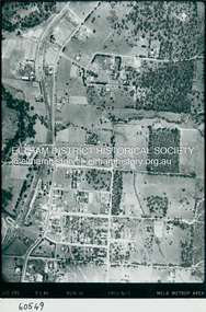
Photograph - Aerial Photograph, Landata, Eltham, Main Road; Henry St to Bellevue Rd, Dec. 1945
... Eltham, Main Road; Henry St to Bellevue Rd......Bellevue Road...Eltham, Main Road; Henry St to Bellevue Rd, and east along Luck St to present day Eltham East School Historic Aerial Imagery Source: Landata.vic.gov.au Aerial Photo Details: Project No :5 Project : MELBOURNE AND METROPOLITAN AREA PROJECT Run : 36 Frame : 60549 Date : 12/1945 Film Type : B/W Camera : EAG4 Flying Height : 10200 Scale : 6000 Film Number : 228 GDA2020 : 37°42'45"S, 145°08'59"E MGA2020 : 336903, 5824465 (55) Melways : 21 K4 (ed. 42)...Eltham District Historical Society Inc 728 Main Rd Eltham melbourne Eltham, Main Road; Henry St to Bellevue Rd, and east along Luck St to present day Eltham East School Historic Aerial Imagery Source: Landata.vic.gov.au Aerial Photo Details: Project No :5 Project : MELBOURNE AND METROPOLITAN AREA PROJECT Run : 36 Frame : 60549 Date : 12/1945 Film Type : B/W Camera : EAG4 Flying Height : 10200 Scale : 6000 Film Number : 228 GDA2020 : 37°42'45"S, 145°08'59"E MGA2020 : 336903, 5824465 (55) Melways : 21 K4 (ed. 42) Aerial Photo Arthur Street Bellevue Road Bible Street Diamond Street Dudley Street Elsa Court Eltham Eltham East Primary School Gahan House henry street Livingstone Road Luck Street Main Road Pryor Street Neil Webster Collection A3 photo print and electronic PDF file Eltham, Main Road; Henry St to Bellevue Rd Photograph Aerial Photograph Landata ...Eltham, Main Road; Henry St to Bellevue Rd, and east along Luck St to present day Eltham East School Historic Aerial Imagery Source: Landata.vic.gov.au Aerial Photo Details: Project No :5 Project : MELBOURNE AND METROPOLITAN AREA PROJECT Run : 36 Frame : 60549 Date : 12/1945 Film Type : B/W Camera : EAG4 Flying Height : 10200 Scale : 6000 Film Number : 228 GDA2020 : 37°42'45"S, 145°08'59"E MGA2020 : 336903, 5824465 (55) Melways : 21 K4 (ed. 42)aerial photo, arthur street, bellevue road, bible street, diamond street, dudley street, elsa court, eltham, eltham east primary school, gahan house, henry street, livingstone road, luck street, main road, pryor street, neil webster collection -
 Eltham District Historical Society Inc
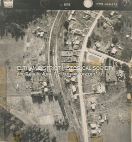
Photograph - Aerial Photograph, Main Road Eltham, cnr Bellevue Rd, 2 Jul. 1951
... Main Road Eltham, cnr Bellevue Rd......Bellevue Road...Eltham District Historical Society Inc 728 Main Rd Eltham melbourne Photo taken for Country Road Board study of Main Road widening shire of eltham archives Aerial Photo Bellevue Road Country Roads Board Eltham Main Road Road widening Black and white proto print Size: 245x230 mm Condition: fair, sticky tape Main Road Eltham, cnr Bellevue Rd Photograph Aerial Photograph ...Photo taken for Country Road Board study of Main Road wideningshire of eltham archives, aerial photo, bellevue road, country roads board, eltham, main road, road widening -
 Bendigo Historical Society Inc.
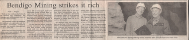
Newspaper - Kangaroo Flat Gold Mine Collection: shaft subsidence, 1995
... ...Bellevue Road...Gold mining Peter Bentley mine shafts subsidence Bellevue Road mine capping Huslters Hill McDuff Gold Mine New Argus Gold Mine 'Bendigo Advertiser' article 9th August, 1995 'The wet brings danger to old gold mine area'. ...'Bendigo Advertiser' article 9th August, 1995 'The wet brings danger to old gold mine area'. Article describes mine shaft subsidence that has occurred in 'roads, parks, backyards and school grounds' following 'heavy rain in the past month'. It was estimated that 'in Bendigo alone there were up to 3000 shafts on private land and about the same number on Crown land, all dotted along the 11 gold reefs between Kangaroo Flat and Eaglehawk'. Black and white photo of Peter Bentley, Mining and Extraction Co-ordinator, North Western region, standing in 'a now capped hole left by the collapse of a shaft at Bendigo'.gold mining, peter bentley, mine shafts, subsidence, bellevue road, mine capping, huslters hill, mcduff gold mine, new argus gold mine -
 Bendigo Historical Society Inc.
Newspaper - Kangaroo Flat Gold Mine Collection: mine shaft capping, 1995
... ...Bellevue Road...Gold mining Peter Bentley mine shafts subsidence Bellevue Road mine capping Huslters Hill McDuff Gold Mine New Argus Gold Mine 'Bendigo Advertiser' article 9th August, 1995 'The wet brings danger to old gold mine area'. ...'Bendigo Advertiser' article 9th August, 1995 'The wet brings danger to old gold mine area'. Article describes mine shaft subsidence that has occurred in 'roads, parks, backyards and school grounds' following 'heavy rain in the past month'. It was estimated that 'in Bendigo alone there were up to 3000 shafts on private land and about the same number on Crown land, all dotted along the 11 gold reefs between Kangaroo Flat and Eaglehawk'. Black and white photo of Peter Bentley, Mining and Extraction Co-ordinator, North Western region, standing in 'a now capped hole left by the collapse of a shaft at Bendigo'.gold mining, peter bentley, mine shafts, subsidence, bellevue road, mine capping, huslters hill, mcduff gold mine, new argus gold mine -
 Bendigo Historical Society Inc.
Document - MCCOLL, RANKIN AND STANISTREET COLLECTION: GOLD MINING LEASE RONALD ALEXANDER RANKIN, 1941
... Document: McColl, Rankin and Stanistreet: lease document between Ronald Alexander Rankin of Bendigo and the State of Victoria. 3 pages with map - lease adjoins Bellevue Road. Lease transferred to Deborah Gold Mines NL in 1945....History House 11 Mackenzie Street Bendigo goldfields ORGANIZATION Mining gold mining lease McColl Rankin and Stanistreet: Ronald Alexander Rankin lease document gold mining Document: McColl, Rankin and Stanistreet: lease document between Ronald Alexander Rankin of Bendigo and the State of Victoria. 3 pages with map - lease adjoins Bellevue Road. Lease transferred to Deborah Gold Mines NL in 1945. ...Document: McColl, Rankin and Stanistreet: lease document between Ronald Alexander Rankin of Bendigo and the State of Victoria. 3 pages with map - lease adjoins Bellevue Road. Lease transferred to Deborah Gold Mines NL in 1945.organization, mining, gold mining lease, mccoll, rankin and stanistreet:, ronald alexander rankin, lease document, gold mining -
 Bendigo Historical Society Inc.
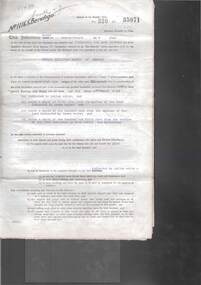
Document - H.A. & S.R. WILKINSON COLLECTION: CONTRACT OF SALE
... Ross (tenant) the landlord lets to the tenant the land and premises described in residence area No. 5446 being the property of the landlord at Bellevue Road, Bendigo at the weekly rental of 2 pounds 10 shillings payable fortnightly in advance from the 18th September, 1954. ...Ross (tenant) the landlord lets to the tenant the land and premises described in residence area No. 5446 being the property of the landlord at Bellevue Road, Bendigo at the weekly rental of 2 pounds 10 shillings payable fortnightly in advance from the 18th September, 1954. ...This business was owned by father and son, Henry Archibald Wilkinson and Samuel Ronald "Ron" Wilkinson. Henry (1882-1954) was born in Shepparton and died in Bendigo. He was married to Grace Hovendon in 1908. Samuel Ronald "Ron" (1914-1995), Henry's son, was married to Florence Jean McKerlie in 1937.Agreement to let and take dated 18th September, 1954 between Mr. F.C. Wilson (landlord) and Mr. C.C. Ross (tenant) the landlord lets to the tenant the land and premises described in residence area No. 5446 being the property of the landlord at Bellevue Road, Bendigo at the weekly rental of 2 pounds 10 shillings payable fortnightly in advance from the 18th September, 1954. Issued by C. Cohen, Solicitor, Pall Mall, Bendigoorganization, business, h.a. & s.r wilkinson real estate -
 Bendigo Historical Society Inc.
Document - ALBERT RICHARDSON COLLECTION: SOUTH BELLEVUE COMPANY, NEW CHUM MINE, STH BELLEVUE UNITED
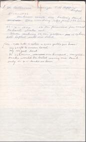
... The New Chum mine location is described as follows: between Breen Street and Bendigo to Melbourne raiway line, approx 220 yards east of intersection of McDougall and Bellevue Roads....The New Chum mine location is described as follows: between Breen Street and Bendigo to Melbourne raiway line, approx 220 yards east of intersection of McDougall and Bellevue Roads. Document ALBERT RICHARDSON COLLECTION: SOUTH BELLEVUE COMPANY, NEW CHUM MINE, STH BELLEVUE UNITED ...Three page document re South Bellevue, South Bellevue United Co and New Chum gold mines. On top of first page ' Sth Bellevue Manager T.M. Hoppers' 11.10 1886 Harkness made on baling tank 23.4.1887 50 ton firewood per week to bail water out, water making 50,000 gallons in 24 hours. All lifted with one tank. History of New Chum Mine detailed including the plant, best gold obtained. The New Chum mine location is described as follows: between Breen Street and Bendigo to Melbourne raiway line, approx 220 yards east of intersection of McDougall and Bellevue Roads.bendigo, mining, south belle vue -
 Bendigo Historical Society Inc.
Document - Hustlers, Sheepshead and Deborah lines of reef
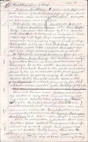
... Central Deborah (1939-1954) shaft 1,347 feet Sheepshead line of reef, Lansell's South Red, White and Blue, shaft 2,124 feet, north east of Bellevue Road and 220 yards east of Adams Road. ...Central Deborah (1939-1954) shaft 1,347 feet Sheepshead line of reef, Lansell's South Red, White and Blue, shaft 2,124 feet, north east of Bellevue Road and 220 yards east of Adams Road. ...Albert Richardson was a mining historian who wrote widely on the mines of the Bendigo Goldfield. The park opposite the Goldmines Hotel in Marong Road, is named in his honour. Five page document, hand written by Albert Richardson on lined foolscap and edited with cross-outs and insertions, . The mines along the Hustlers line of reef and the Sheepshead line of reef are described. Mines listed on Hustlers line of reef: Fortuna Hustlers (1888 - 1913), shaft 2,240 feet at rear of Buckell and Jeffrey's offices; Royal Hustlers Reserve No. 2 - two shafts 'City" 860 feet, now covered by R.S.L. building Pall Mall, steel poppet legs 60 ft high and 'Park Shaft" at rear of Camp Hill School, 1,775 feet, steel poppet legs 60 feet high; Hustlers Hill Group first worked by Jonathan Harris in 1853 and bounded by Valentine, Anderson and Ironbark Creek to the north and Milroy Street to the east, one of first areas worked for quartz reefing. It with Garden Gully line west and Victoria Hill Ironbark, formed by far the richest cross section of the Bendigo Goldfield. Great Extended Hustlers (1865-1921) close to intersection of Anderson Street and Hustlers Road, mullock heap against road and shored up around shaft, steel poppet legs now at Wattle Gully mine, Chewton, large winding machine, air compressor south of shaft and 36 head crushing battery. Hustlers Reef (Old Hustlers) and Hustlers Reef No. 1, two shafts, main 2,210 feet, about 220 yards east of Moran Street and against Fenton Street. , No. 1 shaft 1,140 feet and about 155 yards east of Moran Street. Lansell's Comet, Lightining Hill line, 2.100 feet, on Comet Hill approx 70 yards west of Holmes Road, near Comet Creek, steel poppet legs. United Hustlers and Redan (1876-1918), main Redan, 1,830 feet about 155 yards west of Sandhurst Roead, in line with Comet Hill State School, this hill known as Redan Hill. North, or New Hustlers, once known as Agnew Hustlers, wooden poppet legs, south side, Kneebone Street, Eaglehawk. Derby line, Johnson's No. 3, South Johnson's (east shaft of Collman and Tacchi) 439 feet on west wide of Woods Street, south of Wetherall Street. Paddy's Gully Line, south to north, some shafts - Lansell's 'Sandhurst" ('Needle") Eaglehawk Road shaft 2,425 feet, about 50 yards east of Needle Loops, a brick square sided chimney with Cleopatra Needle top. British American, 789 feet, just south of Holdsworth Road. Collman and Tacchi, main shaft 2,588 feet, 60 yards west of Eaglehawk Road, California Gully. Deborah Line of Reef, The Deborah (1932-1954) shaft 2.017 feet, west of Adams Road and south of Abel Street, Quarry Hill. North Deborah (1937 - 1954) shaft 1,151 feet, Breen Street, Quarry Hill, steel poppet legs. Central Deborah (1939-1954) shaft 1,347 feet Sheepshead line of reef, Lansell's South Red, White and Blue, shaft 2,124 feet, north east of Bellevue Road and 220 yards east of Adams Road. The New Red, White and Blue Consolidated (Big Blue) main shaft 2,416 feet. Lansell's Bendigo Battery 105 head, north of 'Big Blue" on his freehold lease, commenced crushing on 24th February 1895. After closing was erected as the Showground's Industrial Hall, July 1926. North Red, White and Blue, burnt down February 1926, new company 1934, closed 1938. Document is part of the Albert Richardson Collection of Bendigo mining history. bendigo, gold mining, deborah line of reef, sheepshead line of reef, hustlers line of reef, royal hustlers reserve mine, hustlers hill group of mines, great extended hustlers, hustlers reef no. 1, lightning hill line, old comet, collman and tacchi, lansell's comet, north deborah, central deborah, dhrrpdhrsf linr og trrg, new red, white and blue consolidated mine, big blue, lansell's bendigo battery, north red, white and blue mine, albert richardson collection -
 Eltham District Historical Society Inc
Photograph - Digital Copy, Hughes Fruit shop and Milk Bar, Main Road, Eltham, c.1949
... Road, Eltham. Noel worked in the shop after leaving Eltham High School aged 15 (1950), until she married George Williams in 1956, whose grandparents, Violet and Will Williams, owned the Bellevue estate in Livingston Road, Eltham. ...Road, Eltham. Noel worked in the shop after leaving Eltham High School aged 15 (1950), until she married George Williams in 1956, whose grandparents, Violet and Will Williams, owned the Bellevue estate in Livingston Road, Eltham. ...Hughes Fruit Shop and Milk Bar, Main Road, Eltham, c.1949 promoting Peters Ice Cream Immediately to the right of the shop is a bootmaker factory that employed 15 people. It was situated on the corner of Pryor Street and is the site of the present-day Westpac Bank. To the left of the shop are four vacant blocks stretching to Luck Street where Mr and Mrs Britton had a house. On the other side of Pryor Street is the original Blue Gum Cafe and Milk Bar advertising Swallow's Ice Cream. Atr the time it was operated by Pop Warner. Behind the shop is a tall Bluegum tree. This was the tree that the Bluegum Cafe was originally named after. Miss Barber's 'Blue Gum' Soda Fountain opened October 1922 and was the first shop on the eastern side of Main Road following Luther Haley's Bakery and General Store on the other side adjacent to the railway station in 1902. The Bluegum was felled in the early 1960s when Burge's Blue Gum Cafe and milkbar was sold and demolished in September 1960 to make way for a new store, Mr. J. Millet's Foodland. OLD LANDMARK GOES Perhaps the most famous landmark in Eltham's' business section disappeared last Wednesday when the towering blue gum in Pryor Street at the rear of Main Road shops was felled. The tree, stated to be more than 80 feet high, was the one for which the adjoining café was named, when that business was Eltham’s only provision store, long before the turn of the century. Mr. J. Millett, who now owns the property on which the tree stood, deeply regretted its removal, but was mindful of the need for expansion in the business area. The "Old Blue Gum" was removed by Mr. A. Wilson, expert tree feller, from Heidelberg. Its proportions might be assessed by these facts – it took a gang of experienced men two days to completely fell and clear the tree, and, falling sections being brought down by cable tipped electricity wires on the opposite side of Pryor Street. Images from the private collection of Mrs Noel Williams (nee Hughes) Noel’s parents, George Elgar Hughes and Jean Alice Hughes had a combined milk bar and fruit shop in Main Road, Eltham. Noel worked in the shop after leaving Eltham High School aged 15 (1950), until she married George Williams in 1956, whose grandparents, Violet and Will Williams, owned the Bellevue estate in Livingston Road, Eltham. Her father, then sold the property. George and Noel raised 3 children on their farm in Kangaroo Ground and Noel, who turned 90 years old in July 2025, is a life member of the Andrew Ross Museum.hughes fruit shop and milk bar, main road eltham, george elgar hughes, jean alice hughes, 1949, blue gum (eucalyptus globulus), blue gum milk bar (eltham), eltham shopping centre, eltham shops, fruit shop, green grocer, milk bar, peter's ice cream, pryor street, shoe factory., swallow's ice cream, bedford truck, pop warner, bootmaker's shop -
 Ringwood and District Historical Society
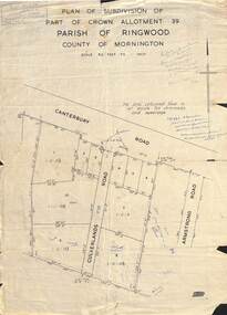
Map - Plan of Subdivision, Part of Crown Allotment 39, Parish of Ringwood, County of Mornington - (Undated - circa 1930s)
... Ringwood and District Historical Society 125A Warrandyte Road Ringwood North melbourne Hand-written sales notations on map and backing include names and telephone numbers - Mr Robinson MJ2411, Mr Smith MX5425, Abicare WY1848. Later notation 12/12/67 - A. Robertson. Rubber stamp imprint in top left corner - D.H. Oliver, Civil Engineer & Licensed Surveyor, Bellevue ...Copy of land title map on light cardboard backing showing layout and size of 11 allotments in Canterbury Road and Culverlands Road, Heathmont, Victoria. Hand-written sales notations on map and backing include names and telephone numbers - Mr Robinson MJ2411, Mr Smith MX5425, Abicare WY1848. Later notation 12/12/67 - A. Robertson. Rubber stamp imprint in top left corner - D.H. Oliver, Civil Engineer & Licensed Surveyor, Bellevue Street Lilydale, Phone Lilydale 91. -
 Ringwood and District Historical Society
Map - Plan of Subdivision, Part of Crown Allotments 39 and 40 Section C, Township of Ringwood, County of Mornington - (Undated - circa 1930s)
... Ringwood and District Historical Society 125A Warrandyte Road Ringwood North melbourne Rubber stamp imprint in top left corner - D.H. Oliver, Civil Engineer & Licensed Surveyor, Bellevue Street Lilydale, Phone Lilydale 91. ...Copy of land title map on light cardboard backing showing layout and size of 6 allotments in Illoura Road (later Illoura Avenue) and Alexandra Road, Ringwood East, Victoria. Rubber stamp imprint in top left corner - D.H. Oliver, Civil Engineer & Licensed Surveyor, Bellevue Street Lilydale, Phone Lilydale 91. -
 Ringwood and District Historical Society
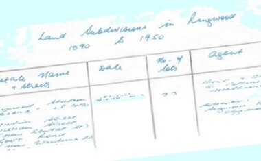
Document - Research Notes, Richard Carter, Land Subdivisions in Ringwood 1890-1950
... (1924) Bedford Road, Adams Street, Anderson Street, Joyce Street, Graham Road Pg26 CROWN JEWEL ESTATE LP11645 (Private sales after 1924) Mount Dandenong Road, Mirabel Avenue, Valda Avenue, Evon Avenue, Velma Grove Pg27 GRAND CENTRAL ESTATE LP10917 (1925) Heathmont Road, Great Ryrie Street, Douglas Street, Garden Street, Bellevue Avenue Pg28 RINGWOOD (unnamed estate - 1926) Nelson Street, Seymour Street, Whitehorse Road Pg29 EAST RINGWOOD RAILWAY STATION ESTATE (YEAR? ...(1924) Bedford Road, Adams Street, Anderson Street, Joyce Street, Graham Road Pg26 CROWN JEWEL ESTATE LP11645 (Private sales after 1924) Mount Dandenong Road, Mirabel Avenue, Valda Avenue, Evon Avenue, Velma Grove Pg27 GRAND CENTRAL ESTATE LP10917 (1925) Heathmont Road, Great Ryrie Street, Douglas Street, Garden Street, Bellevue Avenue Pg28 RINGWOOD (unnamed estate - 1926) Nelson Street, Seymour Street, Whitehorse Road Pg29 EAST RINGWOOD RAILWAY STATION ESTATE (YEAR? ...Handwritten table listing main local pre-1950s subdivisions in the Ringwood area, with estate names, streets, number of allotments for sale, and where known, vendor agent, LP (Lodged Plan) title registration number, and auction/sale date, some with sale price.Pg1 RINGWOOD STATION ESTATE LP3070 (Year?) Station Street, William Street (now Kendall Street), Wantirna Road, Station Street Pg1 RINGWOOD TOWNSHIP ESTATE LP5577 (1913) Station Road (now Warrandyte Road), Pratt Street (part now Aird Street), Whitehorse Road Pg2 RINGWOOD ORCHARD ESTATE LP4315 (1914) Brysons Road, Hillcrest Road, Anzac Avenue, Sulva Road Pg3 RINGWOOD RAILWAY ESTATE LP7522 (1918) Whitehorse Road (now Mount Dandenong Road), Dublin Road, Freeman Street, Patterson Street, Bona Street Pg4 THE RINGWOOD ESTATE LP7578 (1919) Warrandyte Road, Hobart Street, Paxton Street, Arnold Street Pg5 GARDEN FARMS ESTATE (LP?) (1919) Canterbury Road, Armstrong Road, Bungalook Road, Orchard Road, Bayswater Road (now Mountain Highway) Pg6 THE RINGWOOD ESTATE (SECOND SUB-DIVISION) LP7604 (1919) Warrandyte Road, Tamar Street, Derwent Street, Mersey Street Pg7 RINGWOOD STATION ESTATE LP7703 (1919) Bedford Road, Williams Grove (now Lena Grove) Pg8 RINGWOOD TOWNSHIP ESTATE LP8198 (1919) Wantirna Road, Ellison Street, Haig Street, Greenwood Avenue Pg9 EASTFIELD ESTATE (LP?) (1920) Eastfield Road, Longview Road, Pleasant Rise, The Mount Pg10 ELECTRIC RAILWAY ESTATE RINGWOOD LP9473 (1922) Campbell Street, Myrtle Avenue, George Street (now Tudor Court), Henry Street (now Myrtle Avenue), Williams Grove (now Lena Grove) Pg11 RINGWOOD PARK ESTATE LP7884 (1922 - two stages) Wonga Road (now Loughnan Road), William Street, Andrew Street, Harrison Street Pg12 HEATHMONT STATION ESTATE LP11009 (Date? - after 1922) Lisgoold Street, Viviani Crescent, Balrour Avenue, Station Street (now part Heathmont Road and part Wainui Street) Pg13 RINGWOOD RAILWAY ESTATE LP10507 (1923) Whitehorse Road, Sherbrooke Avenue, Burwood Avenue, Bonview Avenue, Heatherbrae Avenue, Grant Crescent Pg14 GARDEN HOMES ESTATE (LP?) (1923) Mullum Road, The Centreway, Wattle Crescent (now Wattle Avenue) Reserve Crescent (now Reserve Road) Pg15 DUBLIN ROAD ESTATE LP11993 (1923) Alexandra Road, Vonadawn Avenue, Green Street, Wood Street, Howard Avenue, Bedford Road, Dublin Road Pg16 CARLINGA ESTATE RINGWOOD LP9620 (1923) Bourke Street, Bond Street, Ringwood Street Pg17 PRATT'S JUNCTION ESTATE (LP?) (1923) Junction Street, Georges Road, Oliver Street, Whitehorse Road Pg18 EAST RINGWOOD ESTATE LP10492 (1923) Bona Street, Patterson Street, Miller Grove, Fairview Avenue, Eastfield Road, Whitehorse Road (now Mount Dandenong Road) Pg19 COLEMAN'S HEATHMONT ESTATE LP9974 (1923) Canterbury Road, Bedford Road, Alvena Crescent, Coleman Street, Leonard Street (now Royal Avenue) Pg20 RINGWOOD HEIGHTS ESTATE LP10506 (1924) Whitehorse Road, Bonview Avenue, Grant Crescent, Hillcrest Avenue, Heatherbrae Avenue, Margaret Street, Mary Street Pg21 EAST RINGWOOD STATION ESTATE LP10551 (1924) Knaith Road, Wenwood Street, Lois Street, Victoria Street, Station Street (now Railway Avenue) Pg22 GRAND VIEW ESTATE LP11019 (1924) Whitehorse Road, Rupert Street, Herbert Street, Leonard Street Pg23 RINGWOOD RAILWAY ESTATE & RINGWOOD HEIGHTS ESTATE - FINAL SECTIONS LP10506 & LP10507 (1924) Whitehorse Road, Sherbrooke Avenue, Burwood Avenue, Bonview Avenue, Heatherbrae Avenue, Margaret Street, Mary Street, Grant Crescent Pg24 RINGWOOD EAST ELECTRIC STATION ESTATE (LP?) (1924) Railway Parade (now Patterrson Street), Federal Road, Howship Avenue (part now French Street), Dublin Road, Rosedale Crescent Pg25 BEDFORD PARK (now Ringwood Secondary College) (LP?) (1924) Bedford Road, Adams Street, Anderson Street, Joyce Street, Graham Road Pg26 CROWN JEWEL ESTATE LP11645 (Private sales after 1924) Mount Dandenong Road, Mirabel Avenue, Valda Avenue, Evon Avenue, Velma Grove Pg27 GRAND CENTRAL ESTATE LP10917 (1925) Heathmont Road, Great Ryrie Street, Douglas Street, Garden Street, Bellevue Avenue Pg28 RINGWOOD (unnamed estate - 1926) Nelson Street, Seymour Street, Whitehorse Road Pg29 EAST RINGWOOD RAILWAY STATION ESTATE (YEAR? - 25 shops 60 villas) Railway Avenue, Dublin Road, Lawrence Grove, Stanley Avenue, Knaith Road Pg30 CHARM VIEW ESTATE (LP?) (year? - after 1926) Canterbury Road, Heathmont Road, Dickasons Road, Bennjett Avenue, Orchid Street Pg31 SUNBEAM ESTATE LP12150 (Circa 1925) Govt Road (now Old Lilydale Road), Sunbeam Avenue, Holland Road, Everard Street (now Everard Road) Pg32 FAIRVIEW ESTATE EAST RINGWOOD LP10853 (Circa 1924) Eastfield Road, Patterson Street, Margaret Street (now Short Street) Pg33 EAST RINGWOOD TOWNSHIP ESTATE LP3025 (Circa 1924 - 35 allotments) Mount Dandenong Road, Grey Street, Eastfield Road Pg34 EAST RINGWOOD TOWNSHIP ESTATE LP3025 (Circa 1924 - 49 allotments) and STATE SCHOOL ESTATE (26 allotments) and EAST RINGWOOD STATION ESTATE (14 shop sites) Mount Dandenong Road, Grety Street, Dunn Street, Eastfield Road, King Street, Holland Road, Dublin Road, Patterson Street, Bona Street Pg35 EAST RINGWOOD CENTRAL ESTATE LP17004 (1948) Knaith Road, Shasta Avenue, Talofa Avenue, Russet Road, Dublin Road Pg36 WARE ESTATE LP43360 (1958) Ware Crescent, Davey Drive, Grey Road (now Grey Street), Mount Dandenong Road Pg37 Lot 57 Kendall Street LP3070 (1939) £75.0.0 Pg37 Lot 14 LP7346 (year?) £225 Pg37 Lot 8 WHITE HORSE ESTATE LP14010 (year?) Maroondah Hwy, Seymour Street £98.9.0 Pg37 Lots 4-14 incl. LP10902 (year?) £300 Pg37 Lots 69&70 LP2216 (1939) Bedford Road, Pitt Street £500 Pg37 Lots 60&70 LP2216 (year?) £460 Pg37 MOUNTAIN VIEW ESTATE LP10902 (1936) Lots 1&2, 19-22 Wantirna Road, Daisy Street £50 Pg38 RAILWAY STATION ESTATE RINGWOOD EAST LP7522 (1925) Lots 16 to 19 £250 Pg38 RINGWOOD PARK ESTATE (LP?) (1924) Lot 112 Munro Street £230 Pg38 RINGWOOD TOWNSHIP ESTATE (LP?) (1925) Lot 57 Wantirna Road £850 Pg38 ELECTRIC RAILWAY ESTATE LP9473 (1925) Lot 98 & 99 £180 (30/- foot) Pg38 ELECTRIC RAILWAY ESTATE LP9473 (year?) Lot 100 £233.12.6 incl improvements (£2.12.6 foot) Pg38 Lot 22&23 Bedford Road Heathmont (LP & year?) £675 incl improvements Pg39 Lot 9 Mullum Mullum Road LP8221 (1923) £150 Pg39 Lot 27 Haig Street LP8198 (1925) £825 Pg39 Lot 56 Haig Street cnr Wantirna Road LP8198 (1923) £171 Pg39 Lots 3 & 4 Loughnan Road LP9626 (192?) £147 Pg39 Lots 98 & 99 Myrtle Avenue LP9473 (1925) £180 Pg39 Lots 80 & 81 Myrtle Avenue LP9473 (1929) £150 Pg39 Lot 30 Sherbrooke Avenue LP10507 (1926) £700 incl improvements Pg40 Lot 10 (year?) LP7703 £750 Pg40 Lot 36 (year?) LP7522 £25 Pg40 Lot 38 Pitt Street LP2216 (year?) £350 Pg40 Lot 7 Dublin Road cnr Green Street LP11993 (year?) £300 -
 Ringwood and District Historical Society
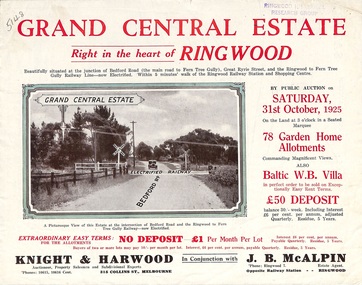
Flyer, Subdivisional Land Auction Sale Brochure, Grand Central Estate, Ringwood, Vic. - 1925
... Subdivision includes Great Ryrie Street, Heathmont Road, Douglas Street, Garden Street, and Bellevue Avenue. Agents - Knight & Harwood, 315 Collins Street, Melbourne, Phone 10615, 10616 Central, in conjunction with J.B. ...Subdivision includes Great Ryrie Street, Heathmont Road, Douglas Street, Garden Street, and Bellevue Avenue. Agents - Knight & Harwood, 315 Collins Street, Melbourne, Phone 10615, 10616 Central, in conjunction with J.B. ...Douglas Street shown in the estate plan did not eventuate, but was developed as a public reserve. Refer also to Reg. No. 5149 for 1924 auction sale of land also titled Grand View Estate situated further north in Ringwood.Double sided multi-folded page advertising public auction sale on Saturday, 31st October, 1925, of residential allotments highlighting local facilities, services and layout of the estate. Includes panoramic view of Ringwood and other local photographic images.Subdivision includes Great Ryrie Street, Heathmont Road, Douglas Street, Garden Street, and Bellevue Avenue. Agents - Knight & Harwood, 315 Collins Street, Melbourne, Phone 10615, 10616 Central, in conjunction with J.B. McAlpin, Opposite Railway Station, Ringwood. Phone Ringwood 7. -
 Andrew Ross Museum
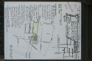
research note, A4, Donaldson property, Waterdale Rd with sketch maps, Early 1990's
... Andrew Ross Museum Main Road (Opposite General Store) Kangaroo Ground melbourne The Donalsdons of Kangaroo Ground owned property fronting Waterdale Rd West Heidelberg, used to camp cattle overnight on their way to/from saleyards in Melbourne. Prepared and used in the writing of "Kangaroo Ground: The Highland Taken (Mick Woiwod 1994) Donaldson Nixon Bellevue ...The Donalsdons of Kangaroo Ground owned property fronting Waterdale Rd West Heidelberg, used to camp cattle overnight on their way to/from saleyards in Melbourne.Prepared and used in the writing of "Kangaroo Ground: The Highland Taken (Mick Woiwod 1994)single sheet with 2 hand-drawn maps, annotated by Bruce Nixon. Notes refer to the Will of James Donaldson (D.1856) Could be a good photocopy with green pencil shading donaldson, nixon, bellevue, wellington house -
 Lake Bolac & District Historical Society
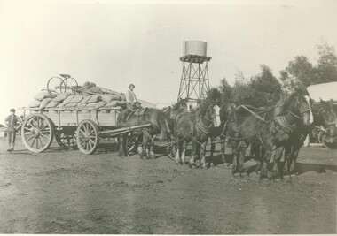
Black and white photograph, Carting wheat on "Bellevue", c.1910
... On the road in front of "Bellevue", Lake Bolac, circa 1910. ...Lake Bolac & District Historical Society 2110 Glenelg Highway Lake Bolac grampians On the road in front of "Bellevue", Lake Bolac, circa 1910. A load of wheat is ready for the trip to the railhead at Willaura. ...On the road in front of "Bellevue", Lake Bolac, circa 1910. A load of wheat is ready for the trip to the railhead at Willaura. Seated on the wagon is Bert Moreton and standing at the rear is Harry Hewitt. Note the home-made gig perched on top of the load.lake bolac, bellevue, moreton, hewitt, wheat, willaura, -
 Whitehorse Historical Society Inc.
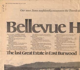
Newspaper - Advertisement, Bellevue Hill, 1971
... Newspaper cutting advertising sale of Bellevue Hill Estate, East Burwood in 1971. Comprising 113 home sites. Estate bordered by Mahoneys Road and Springvale Road...Estate bordered by Mahoneys Road and Springvale Road Bellevue Hill Newspaper Advertisement ...Newspaper cutting advertising sale of Bellevue Hill Estate, East Burwood in 1971. Comprising 113 home sites. Estate bordered by Mahoneys Road and Springvale Roadland subdivision, land sales, development underwriting pty. ltd., mahoneys road, burwood east, springvale road, the sun property guide -
 Whitehorse Historical Society Inc.
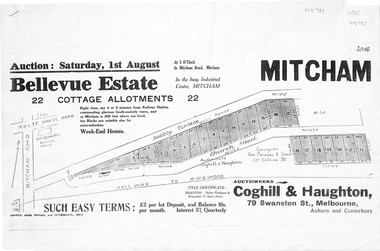
Pamphlet, Bellevue Estate, ca 1927
... Whitehorse Historical Society Inc. 2-10 Deep Creek Road Mitcham melbourne land sales barkly terrace mitcham church street bellevue estate coghill & haughton Land sale of 22 allotments at Mitcham ca 1927 bounded by Barkly Terrace and Church Street. ...Land sale of 22 allotments at Mitcham ca 1927 bounded by Barkly Terrace and Church Street.land sales, barkly terrace, mitcham, church street, bellevue estate, coghill & haughton -
 Mont De Lancey
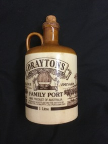
Domestic object - Ceramic flagon, Drayton & Sons Pty. Ltd, Unknown
... Mont De Lancey 71 Wellington Road Wandin North yarra-valley-and-dandenong-ranges Flagons are vessels with a handle and spout used to hold alcoholic beverages, usually wine. In colonial times it would have been set on a table to share with friends or family. Jugs Pouring vessels Flagons Containers Stoneware 'Draytons Bellevue ...Flagons are vessels with a handle and spout used to hold alcoholic beverages, usually wine. In colonial times it would have been set on a table to share with friends or family.A brown and beige ceramic Port wine flagon or jug, with a handle and cork stopper.'Draytons Bellevue Vineyards Family Port. Wine product of Australia. Produced and bottled on the estate by Drayton & Sons Pty. Ltd. Pokolbin 2320. 1 Litre'jugs, pouring vessels, flagons, containers, stoneware -
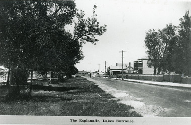 Lakes Entrance Historical Society
Photograph - The Esplanade Lakes Entrance c1920
... Black and white photograph of Esplanade, showing Maranui Guest House, Police Station, corner of Bellevue Guest House and Club Hotel in distance. Natural vegetation of Coastal Banksia on grass verge between road and waterfront, and beside Maranui Guest House. ...Also 10 x 15 cm sepia copy, has remnants of glue of the back, little bit faded Waterfront Township Guesthouses Police The Esplanade Lakes Entrance Black and white photograph of Esplanade, showing Maranui Guest House, Police Station, corner of Bellevue Guest House and Club Hotel in distance. Natural vegetation of Coastal Banksia on grass verge between road and waterfront, and beside Maranui Guest House. ...Also 10 x 15 cm sepia copy, has remnants of glue of the back, little bit fadedBlack and white photograph of Esplanade, showing Maranui Guest House, Police Station, corner of Bellevue Guest House and Club Hotel in distance. Natural vegetation of Coastal Banksia on grass verge between road and waterfront, and beside Maranui Guest House. Lakes Entrance VictoriaThe Esplanade Lakes Entrancewaterfront, township, guesthouses, police -
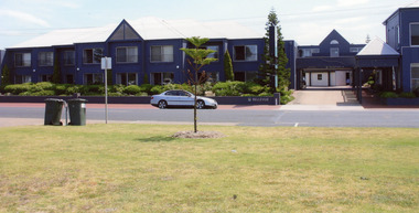 Lakes Entrance Historical Society
Photograph - Bellevue Complex Lakes Entrance 2008
... Colour photograph Bellevue Complex showing driveway with a walk-over bridge. Car parked on road in front of complex. ...Date made August 2008 Resort Transport Room display Colour photograph Bellevue Complex showing driveway with a walk-over bridge. Car parked on road in front of complex. ...Date made August 2008Colour photograph Bellevue Complex showing driveway with a walk-over bridge. Car parked on road in front of complex. It is on the site of Vizes Bellevue and Police Station, situated on Esplanade, Lakes Entrance, Victoria.resort, transport, room display -
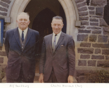 Lakes Entrance Historical Society
Photograph - Alf Sandburg and Charles Hancock Senior 1996
... both of Lakes Entrance taken at a church doorway believed to be St Georges Glenferrie Road Malvern Victoria Religion Social History Colour photograph showing Alf Sandburg of Bellevue Guest House with Charles Hancock Senior Photograph Alf Sandburg and Charles Hancock Senior 1996 ...both of Lakes Entrance taken at a church doorway believed to be St Georges Glenferrie Road Malvern VictoriaColour photograph showing Alf Sandburg of Bellevue Guest House with Charles Hancock Seniorreligion, social history