Showing 767 items matching "benalla"
-
 Lilydale RSL Sub Branch
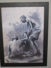
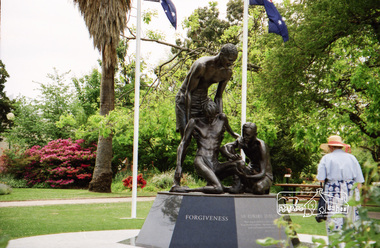
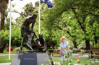
Pencil drawing, The "Weary' Dunlop Memorial, Benalla, 1990
... The "Weary' Dunlop Memorial, Benalla...Framed copy of a pencil drawing of the "Weary" Dunlop Memorial, Benalla...Label on back reads: This is a copy of a pencil drawing of the "Weary" Dunlop Memorial in the Rose Gardens at Benalla, Vic The drawing was done in 1990 by an intellectualy (sic) handicapped man who calls himself "Davo". ...Benalla, Victoria, Australia...Presented to the Lilydale RSL by Ted Polkinghorne brother of Len deceased, 2014 Framed copy of a pencil drawing of the "Weary" Dunlop Memorial, Benalla The "Weary' Dunlop Memorial, Benalla Pencil drawing ...Framed copy of a pencil drawing of the "Weary" Dunlop Memorial, BenallaLabel on back reads: This is a copy of a pencil drawing of the "Weary" Dunlop Memorial in the Rose Gardens at Benalla, Vic The drawing was done in 1990 by an intellectualy (sic) handicapped man who calls himself "Davo". Presented to the Lilydale RSL by Ted Polkinghorne brother of Len deceased, 2014 -
 Melbourne Legacy
Document - Speech, Benalla, Euroa, Violet Town Group - Change Over Dinner, 2006
... Benalla, Euroa, Violet Town Group - Change Over Dinner...Benalla...Two speeches by Legatee Bill Rogers to the Benalla, Euroa, Violet Town group of Melbourne Legacy at the change over dinner in 2006 and again in 2007. ...Print out x 3 pages of 2 speeches by President Legatee Bill Rogers to the Benalla, Euroa and Violet Town Group in 2006 and 2007....Benalla, Euroa, Violet Town Group - Change Over Dinner Document Speech ...Two speeches by Legatee Bill Rogers to the Benalla, Euroa, Violet Town group of Melbourne Legacy at the change over dinner in 2006 and again in 2007. He mentions the need for change as the widows were growing older, the redevelopment of Legacy House, and increasing the marketing of the Legacy brand using specialists. Document was from a folder of documents donated to the archive by Legatee Bill Rogers that related to his time as President (March 2006 - March 2008).A record of Legacy in 2006 and 2007.Print out x 3 pages of 2 speeches by President Legatee Bill Rogers to the Benalla, Euroa and Violet Town Group in 2006 and 2007.benalla, euroa, violet town, bill rogers, change over -
 Melbourne Legacy
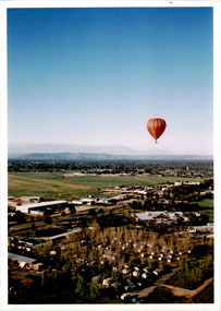
Photograph - Junior legatee outing, Ballooning in Benalla, 2003
... Ballooning in Benalla...The photos show a balloon ride over Benalla. There are other balloons in the air. ...Colour photo x 3 of a balloon ride over Benalla....Colour photo x 3 of a balloon ride over Benalla. Ballooning in Benalla Photograph Junior legatee outing ...Legacy have many programs to send young junior legatees on activities, camps and outings. The photos show a balloon ride over Benalla. There are other balloons in the air. There are more photos of the event, a note with the photos say it was 'Ballooning weekend at Benalla 2003'.A record of a Legacy providing experiences for the junior legatees.Colour photo x 3 of a balloon ride over Benalla.Printed on the back 'No.8A' to '10A' which are the image numbers.junior legatee outing, ballooning -
 Melbourne Legacy
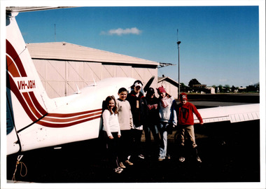
Photograph - Junior legatee outing, Ballooning in Benalla, 2003
... Ballooning in Benalla...The photos show junior legatees after their balloon ride over Benalla. There are more photos of the event, a note with the photos say it was 'Ballooning weekend at Benalla 2003'....Colour photo x 3 of junior legatees at an airport in Benalla after their balloon ride....The photos show junior legatees after their balloon ride over Benalla. There are more photos of the event, a note with the photos say it was 'Ballooning weekend at Benalla 2003'. ...Legacy have many programs to send young junior legatees on activities, camps and outings. The photos show junior legatees after their balloon ride over Benalla. There are more photos of the event, a note with the photos say it was 'Ballooning weekend at Benalla 2003'.A record of a Legacy providing experiences for the junior legatees.Colour photo x 3 of junior legatees at an airport in Benalla after their balloon ride.Printed on the back 'No.12A' to '14A' which are the image numbers.junior legatee outing, ballooning, planes -
 Melbourne Legacy
Photograph - Junior legatee outing, Ballooning in Benalla, 2003
... Ballooning in Benalla...The photos show junior legatees being provided with food after their balloon ride over Benalla. There are more photos of the event, a note with the photos say it was 'Ballooning weekend at Benalla 2003'....Colour photo x 3 of junior legatees being fed at an airport in Benalla after their balloon ride....The photos show junior legatees being provided with food after their balloon ride over Benalla. There are more photos of the event, a note with the photos say it was 'Ballooning weekend at Benalla 2003'. ...Legacy have many programs to send young junior legatees on activities, camps and outings. The photos show junior legatees being provided with food after their balloon ride over Benalla. There are more photos of the event, a note with the photos say it was 'Ballooning weekend at Benalla 2003'.A record of a Legacy providing experiences for the junior legatees.Colour photo x 3 of junior legatees being fed at an airport in Benalla after their balloon ride.Printed on the back 'No.18A' to '20A' which are the image numbers.junior legatee outing, ballooning -
 Musculoskeletal Health Australia (now held by the Glen Eira Historical Society)
Photograph - Group photo, XX/05/1993
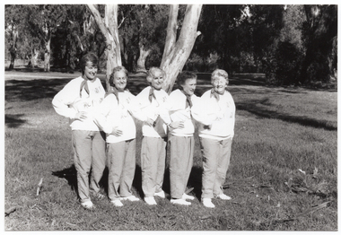
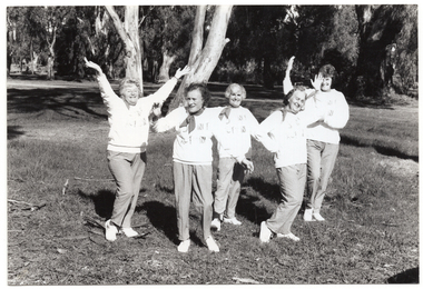
... ... benalla...In May 1993, the Arthritis Foundation of Victoria held a Self Help Group Seminar in Benalla. In this photo, members of the Joint Action Group (JAG) pose for a photo in a park at Benalla....[Handwritten in pencil] JA at Benalla SHG May 1993...Benalla, Victoria, Australia...Musculoskeletal Health Australia (now held by the Glen Eira Historical Society) 965 Glen Huntly Road Caulfield melbourne In May 1993, the Arthritis Foundation of Victoria held a Self Help Group Seminar in Benalla. In this photo, members of the Joint Action Group (JAG) pose for a photo in a park at Benalla. arthritis foundation of victoria afv outreach self help groups seminar joint action group jag marie iredale mavis martin beryl douglas eveline lee sandy exall benalla 1993 [Handwritten in pencil] JA at Benalla SHG May 1993 B&W photo of a five women posing for a photo in a park. ...In May 1993, the Arthritis Foundation of Victoria held a Self Help Group Seminar in Benalla. In this photo, members of the Joint Action Group (JAG) pose for a photo in a park at Benalla.B&W photo of a five women posing for a photo in a park. They are standing close to one another in a line, at a 45 degree angle, with one hand on one hip. They are each wearing a sweatshirt printed with the "Joint Action" logo. There are several trees in the background, with one very large tree directly behind them.[Handwritten in pencil] JA at Benalla SHG May 1993arthritis foundation of victoria, afv, outreach, self help groups, seminar, joint action group, jag, marie iredale, mavis martin, beryl douglas, eveline lee, sandy exall, benalla, 1993 -
 Musculoskeletal Health Australia (now held by the Glen Eira Historical Society)
Photograph - Group photo, XX/05/1993
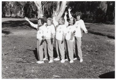
... ... benalla...In May 1993, the Arthritis Foundation of Victoria held a Self Help Group Seminar in Benalla. In this photo, members of the Joint Action Group (JAG) pose for a photo in a park at Benalla....[Handwritten in pencil] [tick] Mavis 1 JA at Benalla 1993...Benalla, Victoria, Australia...Musculoskeletal Health Australia (now held by the Glen Eira Historical Society) 965 Glen Huntly Road Caulfield melbourne In May 1993, the Arthritis Foundation of Victoria held a Self Help Group Seminar in Benalla. In this photo, members of the Joint Action Group (JAG) pose for a photo in a park at Benalla. arthritis foundation of victoria afv outreach self help groups seminar joint action group jag marie iredale mavis martin beryl douglas eveline lee sandy exall benalla 1993 [Handwritten in pencil] [tick] Mavis 1 JA at Benalla 1993 B&W photo of a five women posing for a photo in a park. ...In May 1993, the Arthritis Foundation of Victoria held a Self Help Group Seminar in Benalla. In this photo, members of the Joint Action Group (JAG) pose for a photo in a park at Benalla.B&W photo of a five women posing for a photo in a park. They are standing close to one another in a line, at a 45 degree angle, with both arms outstretched. They are each wearing a sweatshirt printed with the "Joint Action" logo. There are several trees in the background, with one very large tree directly behind them.[Handwritten in pencil] [tick] Mavis 1 JA at Benalla 1993arthritis foundation of victoria, afv, outreach, self help groups, seminar, joint action group, jag, marie iredale, mavis martin, beryl douglas, eveline lee, sandy exall, benalla, 1993 -
 Kiewa Valley Historical Society
Bottle - Soft Drink, 1930s - 1940s
... ...benalla...Hadden's company in Benalla....On the other side of the bottle: 'This bottle is the property / of R.J.Hadden, Benalla.' Base: ...Benalla, North East Victoria, Victoria, Australia...Hadden's company in Benalla. Historical: Change of bottles - shape, glass, stopper. embossing, use. ...Soft drink came in bottles bought at the local grocery store or at a large city store on a shopping expedition. The shape of the bottles changed as did the stopper used to seal it. Bottles were re cycled remaining the property of the manufacturer. History of R.J. Hadden's company in Benalla.Historical: Change of bottles - shape, glass, stopper. embossing, use. Aesthetic: Display showing embossing & shape especially if in good condition.Clear glass bottle heavily embossed. It was used for lemonade. It has straight sides that taper towards the opening two thirds of the way up. On 1 side the company's logo forms a circle with the word 'lemonade' embossed horizontally inside the circle. On the other side, at the base, are 2 lines of embossing.R. J. HADDEN - moon shape across the top forming the top of a circle with BENALLA completing the circle below. LEMONADE is embossed horizontally inside this circle. On the other side of the bottle: 'This bottle is the property / of R.J.Hadden, Benalla.' Base: lemonade, benalla, bottle, drink, r.j.hadden, soft drink -
 Wodonga & District Historical Society Inc
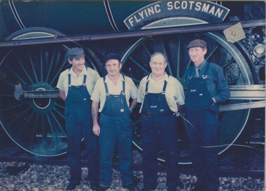
Photograph - Fred Rochow Railways Collection - "The Flying Scotsman" changing crews at Benalla, 11 December 1988
... Fred Rochow Railways Collection - "The Flying Scotsman" changing crews at Benalla...Left to right: Marty McGrath (Wodonga); Kevin Moulday (Benalla); John Wirgess (Wodonga; Barry Dunne (Benalla)....Left to right: Marty McGrath (Wodonga); Kevin Moulday (Benalla); John Wirgess (Wodonga; Barry Dunne (Benalla). ...The Fred Rochow Railways Collection incorporates photos related to the operation of the Wodonga Railway Station including different types of trains and railways staff C. 1930 – 1990. It was donated to the Wodonga Historical Society by Fred Rochow, a railwayman who spent many years based in Wodonga. He joined the Victorian Railways on 17th June l947 and retired in 1988. For some time, he was a member of the Australian Federated Union of Locomotive Enginemen and served a term as a member of the Trades Hall Council. He had an extensive knowledge of the struggles that took place to achieve better conditions for railway workers. Fred worked for many years as a fireman and then worked his way up the ranks to driver, experiencing many changes from the days of steam locomotives through to diesel trains, locomotives and even the modern XPT train. He worked throughout Victoria at different stages of his career, with his final working years focused on the northeast of Victoria and the Albury to Melbourne line. After his retirement, Fred continued to share his love of steam miniature trains with the community.This collection has local and statewide significance as it captures images of trains, locomotives and personnel who operated the railway services in Wodonga and throughout Northeast Victoria. The railways played a critical role in opening up Victoria and connecting Australia for trade, business, social communication and transport.Crewmen changing over at Benalla during the "Flying Scotsman" Bicentennial Tour in 1988. Left to right: Marty McGrath (Wodonga); Kevin Moulday (Benalla); John Wirgess (Wodonga; Barry Dunne (Benalla). On side of locomotive "FLYING SCOTSMAN"railways wodonga, fred rochow, flying scotsman, australia bicentennial -
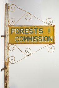 Department of Energy, Environment and Climate Action
FCV Benalla Forest District office sign
... This sign had been hanging outside the front door of the Benalla Forest District Office but was removed after amalgamation of government departments. ...Benalla Forest District Office Sign...Benalla...This sign had been hanging outside the front door of the Benalla Forest District Office but was removed after amalgamation of government departments. ...This sign had been hanging outside the front door of the Benalla Forest District Office but was removed after amalgamation of government departments. It was salvaged from being thrown out in about 1987. The sign features a pine tree (so probably made before the 1956 restructure). In 1956, the new Chairman of the Forests Commission, Alf Lawrence, introduced a major restructure of the organisation to create 56 Forest Districts. The process included amalgamating the plantations and hardwood divisions, which had been separate and rival entities up to that time. Things remained largely unchanged for the next three decades until the early 1980s. The iconic Forests Commission Victoria (FCV) “two-tree” logo was designed in the early 1960s by graphic artist, Alan Rawady.Benalla Forest District Office Sign -
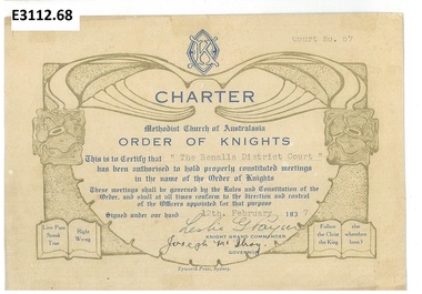 Uniting Church Archives - Synod of Victoria
Certificate - Methodist Order of Knights, Charter The Benalla District Court
... Charter The Benalla District Court...This is the Charter for The Benalla District Court, Court No 67, dated 12th February 1937. ..."Court No. 67" "The Benalla District Court" "12 February 1937" "Leslie G Payser" "Joseph McIlroy"...Uniting Church Archives - Synod of Victoria 54 Serrell Street Malvern East melbourne This is the Charter for The Benalla District Court, Court No 67, dated 12th February 1937. ...This is the Charter for The Benalla District Court, Court No 67, dated 12th February 1937. The Methodist Order of Knights was the official youth organisation of the Methodist Church of Australasia. It originated in Hurstville, NSW, on the 4th October 1914 by the then Mr and later Rev Alex Bray. Alex Bray was a Sunday School teacher and spoke to his class of the Knights of the Round Table. In 1917 the Order of Knights was officially recognised by the Sunday School Dept of the NSW Methodist Conference. Courts spread thoroughout Australia. In 1927 the High Court of NSW called for designs for a badge and in 1929 the General Conference of the Methodist Church of Australasia recognised the Order as an approved Organisation. In 1938 the Senior Section was organised into Degrees of Sincerity, Service and Sacrifice; the Junior Section into Pages' Degree with advancement to Esquire. In 1954 the Junior Section was reorganised into two groups: Pages 8 to 11 years and Esquires 12 to 15 years. The Knight's Motto: "Live Pure, Speak True, Right Wrong, Follow Christ the King, else wherefore born?" Courts of the Order: General Conference Department of the Christian Education - General Court - Provincial High Court - District Court - Local Court - Senior Court - Intermediate Court - Junior Court . Regalia: All members of the Intermediate and Senior Courts wore regalia consisting of a cloth shield superimposed by a cross of light and dark blue ribbons, and supported by a cloth collar. Esquire and Degree of Sincerity regalia: White collar and white shield. Degree of Service regalia: Green collar and shield. Degree of Sacrifice: Scarlet collar and shield. District Court regalia: Blue collar and gold shield. High Court regalia: Gold collar and purple sheild. General Court regalia: Purple collar and shield. Officers of the local courts wore their symbols as part of their regalia.Card Methodist Church of Australasia Methodist Order of Knights Charter with the MOK symbol at the top and brown decorative border and blue text."Court No. 67" "The Benalla District Court" "12 February 1937" "Leslie G Payser" "Joseph McIlroy"methodist order of knights the benalla district court, leslie g payser, joseph mcilroy -
 Melbourne Legacy
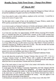
Document, Benalla, Euroa, Violet Town Group - Change Over Dinner, 2007
... Benalla, Euroa, Violet Town Group - Change Over Dinner...Benalla...A copy of a speech given by President Bill Rogers to the Benalla, Euroa, Violet Town Group change over dinner in 2007. ...Benalla, Euroa, Violet Town Group - Change Over Dinner Document ...A copy of a speech given by President Bill Rogers to the Benalla, Euroa, Violet Town Group change over dinner in 2007. He was installing Legatee Leon Dyer as President of the Group. He mentions the 141,000 widows receiving DVA benefits. He mentions Younger Veterans Forum for veterans post 1975. Document was from a folder of documents donated to the archive by Legatee Bill Rogers that related to his time as President (March 2006 - March 2008).A record of the branches and groups at the time.Print out x 1 page of a speech given by President Bill Rogers to a Group dinner on 24 March 2007.benalla, euroa, violet town, changeover dinner -
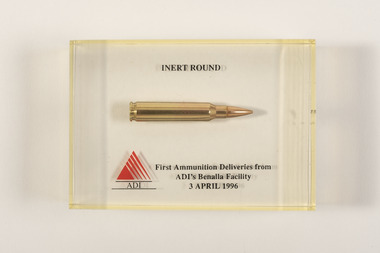 Beechworth RSL Sub-Branch
Souvenir - Cartridge, Memorial, 3 April 1996
... The Benalla site produces ammunition, explosive ordnance and other munitions...."INERT ROUND" "First Ammunition Deliveries from" "ADI'S Benalla Facility" "3 April 1996"...Benalla, Victoria, Australia...The Benalla site produces ammunition, explosive ordnance and other munitions. ...Australian munitions is the largest supplier of explosive munitions to the Australian Defence Force. Australian Munitions can trace its ammunition heritage back to the late 19th century, through the establishment of the Colonial Ammunition Company in Victoria. Manufacturing is based at two main regional sites – Benalla in Victoria and Mulwala in New South Wales. The Benalla site produces ammunition, explosive ordnance and other munitions.This cartridge represents the first ammunition delivery from the site upon its opening in 1996.Single 5.56mm cartridge, encased in resin. Text and images on resin."INERT ROUND" "First Ammunition Deliveries from" "ADI'S Benalla Facility" "3 April 1996"cartridge, ammunition, round, adi, australian munitions, bullet -
 Musculoskeletal Health Australia (now held by the Glen Eira Historical Society)
Photograph - Group photo, XX/05/1993
... ... benalla...In May 1993, the Arthritis Foundation of Victoria held a Self Help Group Seminar in Benalla. In this photo, members of the Joint Action Group (JAG) pose for a photo in a park at Benalla. ...[Handwritten in pencil] [tick] Mavis 1 [tick] Marie 1 [tick] Eveline 1 [tick] Sandy 1 JA at Benalla 1993 [On a bright blue sticky note, handwritten in blue ink] Annual Report 1993 pg 6 "Joint Action" Team...Benalla, Victoria, Australia...Musculoskeletal Health Australia (now held by the Glen Eira Historical Society) 965 Glen Huntly Road Caulfield melbourne In May 1993, the Arthritis Foundation of Victoria held a Self Help Group Seminar in Benalla. In this photo, members of the Joint Action Group (JAG) pose for a photo in a park at Benalla. ...In May 1993, the Arthritis Foundation of Victoria held a Self Help Group Seminar in Benalla. In this photo, members of the Joint Action Group (JAG) pose for a photo in a park at Benalla. A slightly cropped version of this photo appears on page 6 of the 1993 Annual Report with the caption: " "Joint Action" team members Marie Iredale, Mavis Martin, Beryl Douglas, Eveline Lee and Sandy Exall spread the Foundation's positive exercise message throughout Victoria."B&W photo of a five women posing for a photo in a park. They are standing close to one another in a line, at a 45 degree angle. Each woman is striking an individual pose. They are each wearing a sweatshirt printed with the "Joint Action" logo. There are several trees in the background, with one very large tree directly behind them.[Handwritten in pencil] [tick] Mavis 1 [tick] Marie 1 [tick] Eveline 1 [tick] Sandy 1 JA at Benalla 1993 [On a bright blue sticky note, handwritten in blue ink] Annual Report 1993 pg 6 "Joint Action" Teamarthritis foundation of victoria, afv, outreach, self help groups, seminar, joint action group, jag, marie iredale, mavis martin, beryl douglas, eveline lee, sandy exall, benalla, annual report, 1993 -
 8th/13th Victorian Mounted Rifles Regimental Collection
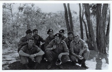
Photograph - Benalla Troop 8/13 VMR
... ...Benalla...In 1965, B Squadron 8th/13th Victorian Mounted Rifles was drawn from Wangaratta and Benalla....Black and white photograph of eight soldoers from Benalla Troop 8th/13th Victorian Mounted Rifles photographed at Benalla Rifle Range c.1971....Photograph Benalla Troop 8/13 VMR ...In 1965, B Squadron 8th/13th Victorian Mounted Rifles was drawn from Wangaratta and Benalla.Collection of photographs showing an armoured regiment of the Citizen Forces in the 1960s as it transitioned from wheeled armoured vehicles to tanks to M113 armoured personal carriers.Black and white photograph of eight soldoers from Benalla Troop 8th/13th Victorian Mounted Rifles photographed at Benalla Rifle Range c.1971." Left Front: Les Firth, Lt. Jackel, Bernie Ginivan, Rear: Laurie Green, Peter Sholders, Lance Gawley, Neville Grant. "jackel, benalla, 8/13 vmr -
 Vision Australia
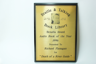
Photograph - Image, Benalla Award Audio Book of the Year 1996
... Benalla Award Audio Book of the Year 1996...Braille and Talking Book Library Tilly Aston 1873 - 1947 ... that all may read Benalla Award Audio Book of the Year 1996 Presented to Richard Flanagan for "Death of a River Guide"...Awards Book of the Year Braille and Talking Book Library Braille and Talking Book Library Tilly Aston 1873 - 1947 ... that all may read Benalla Award Audio Book of the Year 1996 Presented to Richard Flanagan for "Death of a River Guide" Wooden rectangle with metal plate inscribed with winners name Benalla Award Audio Book of the Year 1996 Photograph Image ...This award was presented at an award night hosted by the Braille and Talking Book Library to Richard Flanagan for "Death of a River Guide". As Richard Flanagan did not receive his award on the night the Braille and Talking Book Library kept it for him, however it was not collected. To encourage the development of audio books, a series of awards were established by the National Library of Australia in 1988, and sponsored by TDK from 1991 until their demise in 2000. Open to both commercial and non-commercial publishers, it aimed to recognise the quality achievements by individuals and publishing houses and to promote the inclusion of audio books into the mainstream market.Wooden rectangle with metal plate inscribed with winners nameBraille and Talking Book Library Tilly Aston 1873 - 1947 ... that all may read Benalla Award Audio Book of the Year 1996 Presented to Richard Flanagan for "Death of a River Guide"awards, book of the year, braille and talking book library -
 Eltham District Historical Society Inc
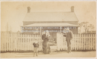
Photograph, Samuel Shillinglaw and family, possibly at Benalla, c.1882
... Samuel Shillinglaw and family, possibly at Benalla......Benalla...At the time of the birth of Arthur Samuel in 1878, Samuel was resident at Benalla, Victoria. Subsequent to this photo, Samuel and Agnes had three further daughters, Barbara Ethel (1884-1898), Lilian Muriel (1887-1939) and Elsie Gladys (1890-1891) Margaret Ball's 2018 book, Shillinglaw Family of Eltham 1660-2007 suggests (page 79) that Arthur Samuel later changed his name to Arthur Ernest to avoid the initials ASS Another copy of same photo in Album 2 is Inscribed on reverse:"For Grandma from Sam" No photographer details CARTE-DE-VISITE (cdv) 1857-1890 Cartes-de-visite (cdv's) are the most common form of photograph from the nineteenth century, generally measuring two and a half inches by four and an eighth inches (6.3 x 10.5 cm) when mounted, sepia toned, mounted on a card which was generally printed with the photographer's name and address on the back or beneath the portrait. - Frost, Lenore; Dating Family Photos 1850-1920; Valiant Press Pty. ...Ltd., Berwick, Victoria 1991 Marg Ball Collection Shillinglaw Family Photo Album 1 1882 Agnes Mary Shillinglaw 1881-1968 Agnes Shillinglaw (nee McIntosh) Arthur Ernest Shillinglaw Arthur Samuel Shillinglaw Benalla house Samuel Shillinglaw (1848-1925) Carte-de-visite (Approx 2 1/2 x 4 1/8 inches or 6.3 x 10.5 cm) Digital file only, scanned from album in private collection Samuel Shillinglaw and family, possibly at Benalla Photograph Photograph ...Believed to be L-R: Arthur Samuel (1878-1907), Agnes Shillinglaw (nee McIntosh 1852-1931) with Agnes Mary (1881-1968), Samuel Shillinglaw (1848-1925). At the time of the birth of Arthur Samuel in 1878, Samuel was resident at Benalla, Victoria. Subsequent to this photo, Samuel and Agnes had three further daughters, Barbara Ethel (1884-1898), Lilian Muriel (1887-1939) and Elsie Gladys (1890-1891) Margaret Ball's 2018 book, Shillinglaw Family of Eltham 1660-2007 suggests (page 79) that Arthur Samuel later changed his name to Arthur Ernest to avoid the initials ASS Another copy of same photo in Album 2 is Inscribed on reverse:"For Grandma from Sam" No photographer details CARTE-DE-VISITE (cdv) 1857-1890 Cartes-de-visite (cdv's) are the most common form of photograph from the nineteenth century, generally measuring two and a half inches by four and an eighth inches (6.3 x 10.5 cm) when mounted, sepia toned, mounted on a card which was generally printed with the photographer's name and address on the back or beneath the portrait. - Frost, Lenore; Dating Family Photos 1850-1920; Valiant Press Pty. Ltd., Berwick, Victoria 1991marg ball collection, shillinglaw family photo album 1, 1882, agnes mary shillinglaw 1881-1968, agnes shillinglaw (nee mcintosh), arthur ernest shillinglaw, arthur samuel shillinglaw, benalla, house, samuel shillinglaw (1848-1925) -
 Eltham District Historical Society Inc
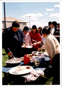
Photograph, Spring Excursion, Hume and Hovell bus tour Stage 2, Seymour, Benalla; 26 Oct 1997, 26/10/1997
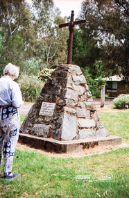
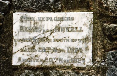
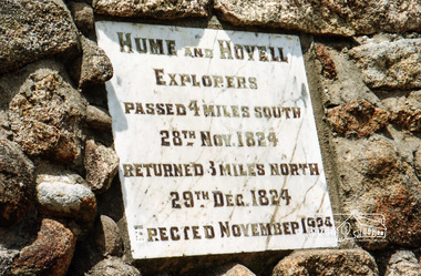
... Spring Excursion, Hume and Hovell bus tour Stage 2, Seymour, Benalla; 26 Oct 1997......benalla...We left the bus and collected up our picnics, dispersed to the various tables and enjoyed the shade from the various European trees. 2.00 pm and we were on the road again driving along the Benalla, Mansfield, Yea road. The Swanpool monument states that they passed four miles south and returned three miles north. ...Record of the Society's history of activities - Spring 1997 excursion shire of eltham historical society activities pretty hill seymour benalla hume and hovell monuments Fuji 200 Roll of 35mm colour negative film, 6 strips Spring Excursion, Hume and Hovell bus tour Stage 2, Seymour, Benalla; 26 Oct 1997 Photograph ...MONUMENT HUNTING THE HUME AND HOVELL WAY (Newsletter No. 117, November 1997, by Diana Bassett-Smith) Sunday October 26 1997 dawned bright and very warm. Some twenty-five members, complete with picnic baskets, met outside the Eltham Library awaiting the Cobb and Co. large coach which would be taking us on the second leg of our travels along the route of the early explorers Hume and Hovell. Stephen West was our very good driver for the day. He would be guided around the circuitous route by Russell Yeoman wh9 had made a detailed study, not only of the intended route, but of the story of these two explorers. During the trip Russell regaled us with poetry, quotations from the Journals and the History of the Shire of Seymour, "The New Crossing Place: by Martindale, 1982, (now Mitchell Shire due to the recent amalgamations). We headed towards the Hume Highway via Greensborough and Cooper Street and proceeded north to our first stop, noting on the way Monument Hill in the distance which is near Kilmore and, according to Russell, well worth the effort to visit as the view across the valley is magnificent. Past Sunday Creek Valley, Mt Piper and Mt Disappointment, all traversed and noted and named by them. We passed through Tallarook, then onto Seymour where we took photos of the monument telling us that Hume and Hovell had passed through on the 28th of October 1824. We also deviated down Hume and Hovell Road viewing deer and emu farming and the Bellbourie property now a sanctuary. Leaving Seymour behind we travelled up the Avenel Road to the Avenel monument, pyramidal in design of four reducing square blocks with a sharply pointed peak, erected in 1924 in memory of the 1824 exploration. The day was warming up and the countryside showing the dryness of the current drought. A parallel note had been made in their journal too of 1824 of the drought appearance of the country they were traversing. At Seven Creeks, Euroa we stopped for some minutes to check the monument placed 20th November 1924 to commemorate their passage on the 29th December 1824. More photos. Russell had pointed out the abrupt termination of the distant ranges which is noted in their journal. The next monument is beside the road at the entrance to Honey Suckle Creek Caravan Park, Violet Town. The squarish shaped monument some eight feet high is topped with a simple steel cross, and was to mark the date of 28th December 1824 and built for the 20th November 1924. By now it was 12.20 and nearly lunchtime as we drove along the Warranbayne Road to Roach's Road, monument hunting without success. Though there is a large, what appears to be an old timber sign which was hard to read, maybe this was the lost monument. In many of the paddocks hay had been cut and baled or was being cut, what a contrast to the rugged country they had passed through which was smoky from the fires of the natives burning off By 1.00 pm we were at Benalla and pulled up beside the park where abundant beds of roses filled the air with their scent and the smell of barbecued food twitched the nostrils whilst the cheerful sounds of other picnickers could be heard throughout the park. We left the bus and collected up our picnics, dispersed to the various tables and enjoyed the shade from the various European trees. 2.00 pm and we were on the road again driving along the Benalla, Mansfield, Yea road. The Swanpool monument states that they passed four miles south and returned three miles north. Then we stopped at the Barjarg monument which notes that they camped near this spot. It is again a pyramidal monument and this time topped with a steel arrow indicating their route of the 29th November 1824. Half an hour later we came to another monument, again with a steel arrow marker on top and the plaque dated the 2nd of 12th 1824. Erected on the 12th of 12th 1924. "They blazed the way that we might inherit the land." Another square based and needle topped monument appeared at Yarck near Yea and this plaque records the date of 3 December 1824. Near McGuigans Road Russell related that the expedition had lost a dog but it had found them next day, the dog was apparently torn by a kangaroo. A short while later Russell reminded us here of the problems they encountered in crossing the Goulburn River near Molesworth where banks were high, water deep and wide. "Good coat of grass but quite dry due to drought". At Yea we stopped for afternoon tea and raided the last of our picnics and looked at the monument to their journey of 1824, situated at a corner of the gardens near the bowling green. No photo – we were out of film. We returned home via Kinglake West and Whittlesea past the Yan Yean Reservoir, not full. 5.00 pm back at Eltham we emptied out of the bus and everyone, including Joan Cole, collected their things, Joan also had the major souvenir of the day, a large carp she had picked up from the river bank, her cat was in for a great feast. The day was made so interesting by the informed commentary which Russell provided. His background knowledge of the route and nature of the journey could only have come from many hours of reading and driving the area. Thank you to Russell and to everyone who made the day so informative and pleasurable. Diana Bassett-Smith. Record of the Society's history of activities - Spring 1997 excursionRoll of 35mm colour negative film, 6 stripsFuji 200shire of eltham historical society, activities, pretty hill, seymour, benalla, hume and hovell, monuments -
 Eltham District Historical Society Inc
Photograph, Spring Excursion, Hume and Hovell bus tour Stage 2, Seymour, Benalla; 26 Oct 1997, 26/10/1997
... Spring Excursion, Hume and Hovell bus tour Stage 2, Seymour, Benalla; 26 Oct 1997......benalla...We left the bus and collected up our picnics, dispersed to the various tables and enjoyed the shade from the various European trees. 2.00 pm and we were on the road again driving along the Benalla, Mansfield, Yea road. The Swanpool monument states that they passed four miles south and returned three miles north. ...Record of the Society's history of activities - Spring 1997 excursion shire of eltham historical society activities pretty hill seymour benalla hume and hovell monuments Kodak Gold 400-5 Roll of 35mm colour negative film, 2 strips Spring Excursion, Hume and Hovell bus tour Stage 2, Seymour, Benalla; 26 Oct 1997 Photograph ...MONUMENT HUNTING THE HUME AND HOVELL WAY (Newsletter No. 117, November 1997, by Diana Bassett-Smith) Sunday October 26 1997 dawned bright and very warm. Some twenty-five members, complete with picnic baskets, met outside the Eltham Library awaiting the Cobb and Co. large coach which would be taking us on the second leg of our travels along the route of the early explorers Hume and Hovell. Stephen West was our very good driver for the day. He would be guided around the circuitous route by Russell Yeoman wh9 had made a detailed study, not only of the intended route, but of the story of these two explorers. During the trip Russell regaled us with poetry, quotations from the Journals and the History of the Shire of Seymour, "The New Crossing Place: by Martindale, 1982, (now Mitchell Shire due to the recent amalgamations). We headed towards the Hume Highway via Greensborough and Cooper Street and proceeded north to our first stop, noting on the way Monument Hill in the distance which is near Kilmore and, according to Russell, well worth the effort to visit as the view across the valley is magnificent. Past Sunday Creek Valley, Mt Piper and Mt Disappointment, all traversed and noted and named by them. We passed through Tallarook, then onto Seymour where we took photos of the monument telling us that Hume and Hovell had passed through on the 28th of October 1824. We also deviated down Hume and Hovell Road viewing deer and emu farming and the Bellbourie property now a sanctuary. Leaving Seymour behind we travelled up the Avenel Road to the Avenel monument, pyramidal in design of four reducing square blocks with a sharply pointed peak, erected in 1924 in memory of the 1824 exploration. The day was warming up and the countryside showing the dryness of the current drought. A parallel note had been made in their journal too of 1824 of the drought appearance of the country they were traversing. At Seven Creeks, Euroa we stopped for some minutes to check the monument placed 20th November 1924 to commemorate their passage on the 29th December 1824. More photos. Russell had pointed out the abrupt termination of the distant ranges which is noted in their journal. The next monument is beside the road at the entrance to Honey Suckle Creek Caravan Park, Violet Town. The squarish shaped monument some eight feet high is topped with a simple steel cross, and was to mark the date of 28th December 1824 and built for the 20th November 1924. By now it was 12.20 and nearly lunchtime as we drove along the Warranbayne Road to Roach's Road, monument hunting without success. Though there is a large, what appears to be an old timber sign which was hard to read, maybe this was the lost monument. In many of the paddocks hay had been cut and baled or was being cut, what a contrast to the rugged country they had passed through which was smoky from the fires of the natives burning off By 1.00 pm we were at Benalla and pulled up beside the park where abundant beds of roses filled the air with their scent and the smell of barbecued food twitched the nostrils whilst the cheerful sounds of other picnickers could be heard throughout the park. We left the bus and collected up our picnics, dispersed to the various tables and enjoyed the shade from the various European trees. 2.00 pm and we were on the road again driving along the Benalla, Mansfield, Yea road. The Swanpool monument states that they passed four miles south and returned three miles north. Then we stopped at the Barjarg monument which notes that they camped near this spot. It is again a pyramidal monument and this time topped with a steel arrow indicating their route of the 29th November 1824. Half an hour later we came to another monument, again with a steel arrow marker on top and the plaque dated the 2nd of 12th 1824. Erected on the 12th of 12th 1924. "They blazed the way that we might inherit the land." Another square based and needle topped monument appeared at Yarck near Yea and this plaque records the date of 3 December 1824. Near McGuigans Road Russell related that the expedition had lost a dog but it had found them next day, the dog was apparently torn by a kangaroo. A short while later Russell reminded us here of the problems they encountered in crossing the Goulburn River near Molesworth where banks were high, water deep and wide. "Good coat of grass but quite dry due to drought". At Yea we stopped for afternoon tea and raided the last of our picnics and looked at the monument to their journey of 1824, situated at a corner of the gardens near the bowling green. No photo – we were out of film. We returned home via Kinglake West and Whittlesea past the Yan Yean Reservoir, not full. 5.00 pm back at Eltham we emptied out of the bus and everyone, including Joan Cole, collected their things, Joan also had the major souvenir of the day, a large carp she had picked up from the river bank, her cat was in for a great feast. The day was made so interesting by the informed commentary which Russell provided. His background knowledge of the route and nature of the journey could only have come from many hours of reading and driving the area. Thank you to Russell and to everyone who made the day so informative and pleasurable. Diana Bassett-Smith. Record of the Society's history of activities - Spring 1997 excursionRoll of 35mm colour negative film, 2 stripsKodak Gold 400-5shire of eltham historical society, activities, pretty hill, seymour, benalla, hume and hovell, monuments -
 Eltham District Historical Society Inc
Photograph, Spring Excursion, Hume and Hovell bus tour Stage 2, Seymour, Benalla; 26 Oct 1997, 26/10/1997
... Spring Excursion, Hume and Hovell bus tour Stage 2, Seymour, Benalla; 26 Oct 1997......benalla...We left the bus and collected up our picnics, dispersed to the various tables and enjoyed the shade from the various European trees. 2.00 pm and we were on the road again driving along the Benalla, Mansfield, Yea road. The Swanpool monument states that they passed four miles south and returned three miles north. ...Record of the Society's history of activities - Spring 1997 excursion shire of eltham historical society activities pretty hill seymour benalla hume and hovell monuments Fuji 200 Roll of 35mm colour negative film, 6 strips Spring Excursion, Hume and Hovell bus tour Stage 2, Seymour, Benalla; 26 Oct 1997 Photograph ...MONUMENT HUNTING THE HUME AND HOVELL WAY (Newsletter No. 117, November 1997, by Diana Bassett-Smith) Sunday October 26 1997 dawned bright and very warm. Some twenty-five members, complete with picnic baskets, met outside the Eltham Library awaiting the Cobb and Co. large coach which would be taking us on the second leg of our travels along the route of the early explorers Hume and Hovell. Stephen West was our very good driver for the day. He would be guided around the circuitous route by Russell Yeoman wh9 had made a detailed study, not only of the intended route, but of the story of these two explorers. During the trip Russell regaled us with poetry, quotations from the Journals and the History of the Shire of Seymour, "The New Crossing Place: by Martindale, 1982, (now Mitchell Shire due to the recent amalgamations). We headed towards the Hume Highway via Greensborough and Cooper Street and proceeded north to our first stop, noting on the way Monument Hill in the distance which is near Kilmore and, according to Russell, well worth the effort to visit as the view across the valley is magnificent. Past Sunday Creek Valley, Mt Piper and Mt Disappointment, all traversed and noted and named by them. We passed through Tallarook, then onto Seymour where we took photos of the monument telling us that Hume and Hovell had passed through on the 28th of October 1824. We also deviated down Hume and Hovell Road viewing deer and emu farming and the Bellbourie property now a sanctuary. Leaving Seymour behind we travelled up the Avenel Road to the Avenel monument, pyramidal in design of four reducing square blocks with a sharply pointed peak, erected in 1924 in memory of the 1824 exploration. The day was warming up and the countryside showing the dryness of the current drought. A parallel note had been made in their journal too of 1824 of the drought appearance of the country they were traversing. At Seven Creeks, Euroa we stopped for some minutes to check the monument placed 20th November 1924 to commemorate their passage on the 29th December 1824. More photos. Russell had pointed out the abrupt termination of the distant ranges which is noted in their journal. The next monument is beside the road at the entrance to Honey Suckle Creek Caravan Park, Violet Town. The squarish shaped monument some eight feet high is topped with a simple steel cross, and was to mark the date of 28th December 1824 and built for the 20th November 1924. By now it was 12.20 and nearly lunchtime as we drove along the Warranbayne Road to Roach's Road, monument hunting without success. Though there is a large, what appears to be an old timber sign which was hard to read, maybe this was the lost monument. In many of the paddocks hay had been cut and baled or was being cut, what a contrast to the rugged country they had passed through which was smoky from the fires of the natives burning off By 1.00 pm we were at Benalla and pulled up beside the park where abundant beds of roses filled the air with their scent and the smell of barbecued food twitched the nostrils whilst the cheerful sounds of other picnickers could be heard throughout the park. We left the bus and collected up our picnics, dispersed to the various tables and enjoyed the shade from the various European trees. 2.00 pm and we were on the road again driving along the Benalla, Mansfield, Yea road. The Swanpool monument states that they passed four miles south and returned three miles north. Then we stopped at the Barjarg monument which notes that they camped near this spot. It is again a pyramidal monument and this time topped with a steel arrow indicating their route of the 29th November 1824. Half an hour later we came to another monument, again with a steel arrow marker on top and the plaque dated the 2nd of 12th 1824. Erected on the 12th of 12th 1924. "They blazed the way that we might inherit the land." Another square based and needle topped monument appeared at Yarck near Yea and this plaque records the date of 3 December 1824. Near McGuigans Road Russell related that the expedition had lost a dog but it had found them next day, the dog was apparently torn by a kangaroo. A short while later Russell reminded us here of the problems they encountered in crossing the Goulburn River near Molesworth where banks were high, water deep and wide. "Good coat of grass but quite dry due to drought". At Yea we stopped for afternoon tea and raided the last of our picnics and looked at the monument to their journey of 1824, situated at a corner of the gardens near the bowling green. No photo – we were out of film. We returned home via Kinglake West and Whittlesea past the Yan Yean Reservoir, not full. 5.00 pm back at Eltham we emptied out of the bus and everyone, including Joan Cole, collected their things, Joan also had the major souvenir of the day, a large carp she had picked up from the river bank, her cat was in for a great feast. The day was made so interesting by the informed commentary which Russell provided. His background knowledge of the route and nature of the journey could only have come from many hours of reading and driving the area. Thank you to Russell and to everyone who made the day so informative and pleasurable. Diana Bassett-Smith. Record of the Society's history of activities - Spring 1997 excursionRoll of 35mm colour negative film, 6 stripsFuji 200shire of eltham historical society, activities, pretty hill, seymour, benalla, hume and hovell, monuments -
 Eltham District Historical Society Inc
Photograph, Spring Excursion, Hume and Hovell bus tour Stage 2, Seymour, Benalla; 26 Oct 1997, 26/10/1997
... Spring Excursion, Hume and Hovell bus tour Stage 2, Seymour, Benalla; 26 Oct 1997......benalla...We left the bus and collected up our picnics, dispersed to the various tables and enjoyed the shade from the various European trees. 2.00 pm and we were on the road again driving along the Benalla, Mansfield, Yea road. The Swanpool monument states that they passed four miles south and returned three miles north. ...Record of the Society's history of activities - Spring 1997 excursion shire of eltham historical society activities pretty hill seymour benalla hume and hovell monuments Fuji 200 Roll of 35mm colour negative film, 6 strips Spring Excursion, Hume and Hovell bus tour Stage 2, Seymour, Benalla; 26 Oct 1997 Photograph ...MONUMENT HUNTING THE HUME AND HOVELL WAY (Newsletter No. 117, November 1997, by Diana Bassett-Smith) Sunday October 26 1997 dawned bright and very warm. Some twenty-five members, complete with picnic baskets, met outside the Eltham Library awaiting the Cobb and Co. large coach which would be taking us on the second leg of our travels along the route of the early explorers Hume and Hovell. Stephen West was our very good driver for the day. He would be guided around the circuitous route by Russell Yeoman wh9 had made a detailed study, not only of the intended route, but of the story of these two explorers. During the trip Russell regaled us with poetry, quotations from the Journals and the History of the Shire of Seymour, "The New Crossing Place: by Martindale, 1982, (now Mitchell Shire due to the recent amalgamations). We headed towards the Hume Highway via Greensborough and Cooper Street and proceeded north to our first stop, noting on the way Monument Hill in the distance which is near Kilmore and, according to Russell, well worth the effort to visit as the view across the valley is magnificent. Past Sunday Creek Valley, Mt Piper and Mt Disappointment, all traversed and noted and named by them. We passed through Tallarook, then onto Seymour where we took photos of the monument telling us that Hume and Hovell had passed through on the 28th of October 1824. We also deviated down Hume and Hovell Road viewing deer and emu farming and the Bellbourie property now a sanctuary. Leaving Seymour behind we travelled up the Avenel Road to the Avenel monument, pyramidal in design of four reducing square blocks with a sharply pointed peak, erected in 1924 in memory of the 1824 exploration. The day was warming up and the countryside showing the dryness of the current drought. A parallel note had been made in their journal too of 1824 of the drought appearance of the country they were traversing. At Seven Creeks, Euroa we stopped for some minutes to check the monument placed 20th November 1924 to commemorate their passage on the 29th December 1824. More photos. Russell had pointed out the abrupt termination of the distant ranges which is noted in their journal. The next monument is beside the road at the entrance to Honey Suckle Creek Caravan Park, Violet Town. The squarish shaped monument some eight feet high is topped with a simple steel cross, and was to mark the date of 28th December 1824 and built for the 20th November 1924. By now it was 12.20 and nearly lunchtime as we drove along the Warranbayne Road to Roach's Road, monument hunting without success. Though there is a large, what appears to be an old timber sign which was hard to read, maybe this was the lost monument. In many of the paddocks hay had been cut and baled or was being cut, what a contrast to the rugged country they had passed through which was smoky from the fires of the natives burning off By 1.00 pm we were at Benalla and pulled up beside the park where abundant beds of roses filled the air with their scent and the smell of barbecued food twitched the nostrils whilst the cheerful sounds of other picnickers could be heard throughout the park. We left the bus and collected up our picnics, dispersed to the various tables and enjoyed the shade from the various European trees. 2.00 pm and we were on the road again driving along the Benalla, Mansfield, Yea road. The Swanpool monument states that they passed four miles south and returned three miles north. Then we stopped at the Barjarg monument which notes that they camped near this spot. It is again a pyramidal monument and this time topped with a steel arrow indicating their route of the 29th November 1824. Half an hour later we came to another monument, again with a steel arrow marker on top and the plaque dated the 2nd of 12th 1824. Erected on the 12th of 12th 1924. "They blazed the way that we might inherit the land." Another square based and needle topped monument appeared at Yarck near Yea and this plaque records the date of 3 December 1824. Near McGuigans Road Russell related that the expedition had lost a dog but it had found them next day, the dog was apparently torn by a kangaroo. A short while later Russell reminded us here of the problems they encountered in crossing the Goulburn River near Molesworth where banks were high, water deep and wide. "Good coat of grass but quite dry due to drought". At Yea we stopped for afternoon tea and raided the last of our picnics and looked at the monument to their journey of 1824, situated at a corner of the gardens near the bowling green. No photo – we were out of film. We returned home via Kinglake West and Whittlesea past the Yan Yean Reservoir, not full. 5.00 pm back at Eltham we emptied out of the bus and everyone, including Joan Cole, collected their things, Joan also had the major souvenir of the day, a large carp she had picked up from the river bank, her cat was in for a great feast. The day was made so interesting by the informed commentary which Russell provided. His background knowledge of the route and nature of the journey could only have come from many hours of reading and driving the area. Thank you to Russell and to everyone who made the day so informative and pleasurable. Diana Bassett-Smith. Record of the Society's history of activities - Spring 1997 excursionRoll of 35mm colour negative film, 6 stripsFuji 200shire of eltham historical society, activities, pretty hill, seymour, benalla, hume and hovell, monuments -
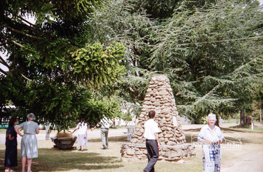 Eltham District Historical Society Inc
Photograph, Spring Excursion, Hume and Hovell bus tour Stage 2, Seymour, Benalla; 26 Oct 1997, 26/10/1997
... Spring Excursion, Hume and Hovell bus tour Stage 2, Seymour, Benalla; 26 Oct 1997......benalla...We left the bus and collected up our picnics, dispersed to the various tables and enjoyed the shade from the various European trees. 2.00 pm and we were on the road again driving along the Benalla, Mansfield, Yea road. The Swanpool monument states that they passed four miles south and returned three miles north. ...Record of the Society's history of activities - Spring 1997 excursion shire of eltham historical society activities pretty hill seymour benalla hume and hovell monuments Fuji 200 Roll of 35mm colour negative film, 6 strips Spring Excursion, Hume and Hovell bus tour Stage 2, Seymour, Benalla; 26 Oct 1997 Photograph ...MONUMENT HUNTING THE HUME AND HOVELL WAY (Newsletter No. 117, November 1997, by Diana Bassett-Smith) Sunday October 26 1997 dawned bright and very warm. Some twenty-five members, complete with picnic baskets, met outside the Eltham Library awaiting the Cobb and Co. large coach which would be taking us on the second leg of our travels along the route of the early explorers Hume and Hovell. Stephen West was our very good driver for the day. He would be guided around the circuitous route by Russell Yeoman wh9 had made a detailed study, not only of the intended route, but of the story of these two explorers. During the trip Russell regaled us with poetry, quotations from the Journals and the History of the Shire of Seymour, "The New Crossing Place: by Martindale, 1982, (now Mitchell Shire due to the recent amalgamations). We headed towards the Hume Highway via Greensborough and Cooper Street and proceeded north to our first stop, noting on the way Monument Hill in the distance which is near Kilmore and, according to Russell, well worth the effort to visit as the view across the valley is magnificent. Past Sunday Creek Valley, Mt Piper and Mt Disappointment, all traversed and noted and named by them. We passed through Tallarook, then onto Seymour where we took photos of the monument telling us that Hume and Hovell had passed through on the 28th of October 1824. We also deviated down Hume and Hovell Road viewing deer and emu farming and the Bellbourie property now a sanctuary. Leaving Seymour behind we travelled up the Avenel Road to the Avenel monument, pyramidal in design of four reducing square blocks with a sharply pointed peak, erected in 1924 in memory of the 1824 exploration. The day was warming up and the countryside showing the dryness of the current drought. A parallel note had been made in their journal too of 1824 of the drought appearance of the country they were traversing. At Seven Creeks, Euroa we stopped for some minutes to check the monument placed 20th November 1924 to commemorate their passage on the 29th December 1824. More photos. Russell had pointed out the abrupt termination of the distant ranges which is noted in their journal. The next monument is beside the road at the entrance to Honey Suckle Creek Caravan Park, Violet Town. The squarish shaped monument some eight feet high is topped with a simple steel cross, and was to mark the date of 28th December 1824 and built for the 20th November 1924. By now it was 12.20 and nearly lunchtime as we drove along the Warranbayne Road to Roach's Road, monument hunting without success. Though there is a large, what appears to be an old timber sign which was hard to read, maybe this was the lost monument. In many of the paddocks hay had been cut and baled or was being cut, what a contrast to the rugged country they had passed through which was smoky from the fires of the natives burning off By 1.00 pm we were at Benalla and pulled up beside the park where abundant beds of roses filled the air with their scent and the smell of barbecued food twitched the nostrils whilst the cheerful sounds of other picnickers could be heard throughout the park. We left the bus and collected up our picnics, dispersed to the various tables and enjoyed the shade from the various European trees. 2.00 pm and we were on the road again driving along the Benalla, Mansfield, Yea road. The Swanpool monument states that they passed four miles south and returned three miles north. Then we stopped at the Barjarg monument which notes that they camped near this spot. It is again a pyramidal monument and this time topped with a steel arrow indicating their route of the 29th November 1824. Half an hour later we came to another monument, again with a steel arrow marker on top and the plaque dated the 2nd of 12th 1824. Erected on the 12th of 12th 1924. "They blazed the way that we might inherit the land." Another square based and needle topped monument appeared at Yarck near Yea and this plaque records the date of 3 December 1824. Near McGuigans Road Russell related that the expedition had lost a dog but it had found them next day, the dog was apparently torn by a kangaroo. A short while later Russell reminded us here of the problems they encountered in crossing the Goulburn River near Molesworth where banks were high, water deep and wide. "Good coat of grass but quite dry due to drought". At Yea we stopped for afternoon tea and raided the last of our picnics and looked at the monument to their journey of 1824, situated at a corner of the gardens near the bowling green. No photo – we were out of film. We returned home via Kinglake West and Whittlesea past the Yan Yean Reservoir, not full. 5.00 pm back at Eltham we emptied out of the bus and everyone, including Joan Cole, collected their things, Joan also had the major souvenir of the day, a large carp she had picked up from the river bank, her cat was in for a great feast. The day was made so interesting by the informed commentary which Russell provided. His background knowledge of the route and nature of the journey could only have come from many hours of reading and driving the area. Thank you to Russell and to everyone who made the day so informative and pleasurable. Diana Bassett-Smith. Record of the Society's history of activities - Spring 1997 excursionRoll of 35mm colour negative film, 6 stripsFuji 200shire of eltham historical society, activities, pretty hill, seymour, benalla, hume and hovell, monuments -
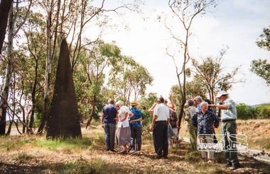 Eltham District Historical Society Inc
Photograph, Spring Excursion, Hume and Hovell bus tour Stage 2, Seymour, Benalla; 26 Oct 1997, 26/10/1997
... Spring Excursion, Hume and Hovell bus tour Stage 2, Seymour, Benalla; 26 Oct 1997......benalla...We left the bus and collected up our picnics, dispersed to the various tables and enjoyed the shade from the various European trees. 2.00 pm and we were on the road again driving along the Benalla, Mansfield, Yea road. The Swanpool monument states that they passed four miles south and returned three miles north. ...Record of the Society's history of activities - Spring 1997 excursion shire of eltham historical society activities pretty hill seymour benalla hume and hovell monuments Fuji 200 Roll of 35mm colour negative film, 6 strips Spring Excursion, Hume and Hovell bus tour Stage 2, Seymour, Benalla; 26 Oct 1997 Photograph ...MONUMENT HUNTING THE HUME AND HOVELL WAY (Newsletter No. 117, November 1997, by Diana Bassett-Smith) Sunday October 26 1997 dawned bright and very warm. Some twenty-five members, complete with picnic baskets, met outside the Eltham Library awaiting the Cobb and Co. large coach which would be taking us on the second leg of our travels along the route of the early explorers Hume and Hovell. Stephen West was our very good driver for the day. He would be guided around the circuitous route by Russell Yeoman wh9 had made a detailed study, not only of the intended route, but of the story of these two explorers. During the trip Russell regaled us with poetry, quotations from the Journals and the History of the Shire of Seymour, "The New Crossing Place: by Martindale, 1982, (now Mitchell Shire due to the recent amalgamations). We headed towards the Hume Highway via Greensborough and Cooper Street and proceeded north to our first stop, noting on the way Monument Hill in the distance which is near Kilmore and, according to Russell, well worth the effort to visit as the view across the valley is magnificent. Past Sunday Creek Valley, Mt Piper and Mt Disappointment, all traversed and noted and named by them. We passed through Tallarook, then onto Seymour where we took photos of the monument telling us that Hume and Hovell had passed through on the 28th of October 1824. We also deviated down Hume and Hovell Road viewing deer and emu farming and the Bellbourie property now a sanctuary. Leaving Seymour behind we travelled up the Avenel Road to the Avenel monument, pyramidal in design of four reducing square blocks with a sharply pointed peak, erected in 1924 in memory of the 1824 exploration. The day was warming up and the countryside showing the dryness of the current drought. A parallel note had been made in their journal too of 1824 of the drought appearance of the country they were traversing. At Seven Creeks, Euroa we stopped for some minutes to check the monument placed 20th November 1924 to commemorate their passage on the 29th December 1824. More photos. Russell had pointed out the abrupt termination of the distant ranges which is noted in their journal. The next monument is beside the road at the entrance to Honey Suckle Creek Caravan Park, Violet Town. The squarish shaped monument some eight feet high is topped with a simple steel cross, and was to mark the date of 28th December 1824 and built for the 20th November 1924. By now it was 12.20 and nearly lunchtime as we drove along the Warranbayne Road to Roach's Road, monument hunting without success. Though there is a large, what appears to be an old timber sign which was hard to read, maybe this was the lost monument. In many of the paddocks hay had been cut and baled or was being cut, what a contrast to the rugged country they had passed through which was smoky from the fires of the natives burning off By 1.00 pm we were at Benalla and pulled up beside the park where abundant beds of roses filled the air with their scent and the smell of barbecued food twitched the nostrils whilst the cheerful sounds of other picnickers could be heard throughout the park. We left the bus and collected up our picnics, dispersed to the various tables and enjoyed the shade from the various European trees. 2.00 pm and we were on the road again driving along the Benalla, Mansfield, Yea road. The Swanpool monument states that they passed four miles south and returned three miles north. Then we stopped at the Barjarg monument which notes that they camped near this spot. It is again a pyramidal monument and this time topped with a steel arrow indicating their route of the 29th November 1824. Half an hour later we came to another monument, again with a steel arrow marker on top and the plaque dated the 2nd of 12th 1824. Erected on the 12th of 12th 1924. "They blazed the way that we might inherit the land." Another square based and needle topped monument appeared at Yarck near Yea and this plaque records the date of 3 December 1824. Near McGuigans Road Russell related that the expedition had lost a dog but it had found them next day, the dog was apparently torn by a kangaroo. A short while later Russell reminded us here of the problems they encountered in crossing the Goulburn River near Molesworth where banks were high, water deep and wide. "Good coat of grass but quite dry due to drought". At Yea we stopped for afternoon tea and raided the last of our picnics and looked at the monument to their journey of 1824, situated at a corner of the gardens near the bowling green. No photo – we were out of film. We returned home via Kinglake West and Whittlesea past the Yan Yean Reservoir, not full. 5.00 pm back at Eltham we emptied out of the bus and everyone, including Joan Cole, collected their things, Joan also had the major souvenir of the day, a large carp she had picked up from the river bank, her cat was in for a great feast. The day was made so interesting by the informed commentary which Russell provided. His background knowledge of the route and nature of the journey could only have come from many hours of reading and driving the area. Thank you to Russell and to everyone who made the day so informative and pleasurable. Diana Bassett-Smith. Record of the Society's history of activities - Spring 1997 excursionRoll of 35mm colour negative film, 6 stripsFuji 200shire of eltham historical society, activities, pretty hill, seymour, benalla, hume and hovell, monuments -
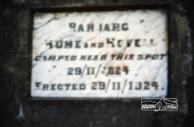 Eltham District Historical Society Inc
Photograph, Spring Excursion, Hume and Hovell bus tour Stage 2, Seymour, Benalla; 26 Oct 1997, 26/10/1997
... Spring Excursion, Hume and Hovell bus tour Stage 2, Seymour, Benalla; 26 Oct 1997......benalla...We left the bus and collected up our picnics, dispersed to the various tables and enjoyed the shade from the various European trees. 2.00 pm and we were on the road again driving along the Benalla, Mansfield, Yea road. The Swanpool monument states that they passed four miles south and returned three miles north. ...Record of the Society's history of activities - Spring 1997 excursion shire of eltham historical society activities pretty hill seymour benalla hume and hovell monuments Fuji 200 Roll of 35mm colour negative film, 6 strips Spring Excursion, Hume and Hovell bus tour Stage 2, Seymour, Benalla; 26 Oct 1997 Photograph ...MONUMENT HUNTING THE HUME AND HOVELL WAY (Newsletter No. 117, November 1997, by Diana Bassett-Smith) Sunday October 26 1997 dawned bright and very warm. Some twenty-five members, complete with picnic baskets, met outside the Eltham Library awaiting the Cobb and Co. large coach which would be taking us on the second leg of our travels along the route of the early explorers Hume and Hovell. Stephen West was our very good driver for the day. He would be guided around the circuitous route by Russell Yeoman wh9 had made a detailed study, not only of the intended route, but of the story of these two explorers. During the trip Russell regaled us with poetry, quotations from the Journals and the History of the Shire of Seymour, "The New Crossing Place: by Martindale, 1982, (now Mitchell Shire due to the recent amalgamations). We headed towards the Hume Highway via Greensborough and Cooper Street and proceeded north to our first stop, noting on the way Monument Hill in the distance which is near Kilmore and, according to Russell, well worth the effort to visit as the view across the valley is magnificent. Past Sunday Creek Valley, Mt Piper and Mt Disappointment, all traversed and noted and named by them. We passed through Tallarook, then onto Seymour where we took photos of the monument telling us that Hume and Hovell had passed through on the 28th of October 1824. We also deviated down Hume and Hovell Road viewing deer and emu farming and the Bellbourie property now a sanctuary. Leaving Seymour behind we travelled up the Avenel Road to the Avenel monument, pyramidal in design of four reducing square blocks with a sharply pointed peak, erected in 1924 in memory of the 1824 exploration. The day was warming up and the countryside showing the dryness of the current drought. A parallel note had been made in their journal too of 1824 of the drought appearance of the country they were traversing. At Seven Creeks, Euroa we stopped for some minutes to check the monument placed 20th November 1924 to commemorate their passage on the 29th December 1824. More photos. Russell had pointed out the abrupt termination of the distant ranges which is noted in their journal. The next monument is beside the road at the entrance to Honey Suckle Creek Caravan Park, Violet Town. The squarish shaped monument some eight feet high is topped with a simple steel cross, and was to mark the date of 28th December 1824 and built for the 20th November 1924. By now it was 12.20 and nearly lunchtime as we drove along the Warranbayne Road to Roach's Road, monument hunting without success. Though there is a large, what appears to be an old timber sign which was hard to read, maybe this was the lost monument. In many of the paddocks hay had been cut and baled or was being cut, what a contrast to the rugged country they had passed through which was smoky from the fires of the natives burning off By 1.00 pm we were at Benalla and pulled up beside the park where abundant beds of roses filled the air with their scent and the smell of barbecued food twitched the nostrils whilst the cheerful sounds of other picnickers could be heard throughout the park. We left the bus and collected up our picnics, dispersed to the various tables and enjoyed the shade from the various European trees. 2.00 pm and we were on the road again driving along the Benalla, Mansfield, Yea road. The Swanpool monument states that they passed four miles south and returned three miles north. Then we stopped at the Barjarg monument which notes that they camped near this spot. It is again a pyramidal monument and this time topped with a steel arrow indicating their route of the 29th November 1824. Half an hour later we came to another monument, again with a steel arrow marker on top and the plaque dated the 2nd of 12th 1824. Erected on the 12th of 12th 1924. "They blazed the way that we might inherit the land." Another square based and needle topped monument appeared at Yarck near Yea and this plaque records the date of 3 December 1824. Near McGuigans Road Russell related that the expedition had lost a dog but it had found them next day, the dog was apparently torn by a kangaroo. A short while later Russell reminded us here of the problems they encountered in crossing the Goulburn River near Molesworth where banks were high, water deep and wide. "Good coat of grass but quite dry due to drought". At Yea we stopped for afternoon tea and raided the last of our picnics and looked at the monument to their journey of 1824, situated at a corner of the gardens near the bowling green. No photo – we were out of film. We returned home via Kinglake West and Whittlesea past the Yan Yean Reservoir, not full. 5.00 pm back at Eltham we emptied out of the bus and everyone, including Joan Cole, collected their things, Joan also had the major souvenir of the day, a large carp she had picked up from the river bank, her cat was in for a great feast. The day was made so interesting by the informed commentary which Russell provided. His background knowledge of the route and nature of the journey could only have come from many hours of reading and driving the area. Thank you to Russell and to everyone who made the day so informative and pleasurable. Diana Bassett-Smith. Record of the Society's history of activities - Spring 1997 excursionRoll of 35mm colour negative film, 6 stripsFuji 200shire of eltham historical society, activities, pretty hill, seymour, benalla, hume and hovell, monuments -
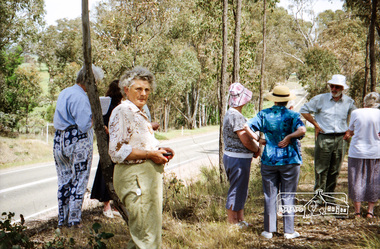 Eltham District Historical Society Inc
Photograph, Spring Excursion, Hume and Hovell bus tour Stage 2, Seymour, Benalla; 26 Oct 1997, 26/10/1997
... Spring Excursion, Hume and Hovell bus tour Stage 2, Seymour, Benalla; 26 Oct 1997......benalla...We left the bus and collected up our picnics, dispersed to the various tables and enjoyed the shade from the various European trees. 2.00 pm and we were on the road again driving along the Benalla, Mansfield, Yea road. The Swanpool monument states that they passed four miles south and returned three miles north. ...Record of the Society's history of activities - Spring 1997 excursion shire of eltham historical society activities pretty hill seymour benalla hume and hovell monuments Fuji 200 Roll of 35mm colour negative film, 6 strips Spring Excursion, Hume and Hovell bus tour Stage 2, Seymour, Benalla; 26 Oct 1997 Photograph ...MONUMENT HUNTING THE HUME AND HOVELL WAY (Newsletter No. 117, November 1997, by Diana Bassett-Smith) Sunday October 26 1997 dawned bright and very warm. Some twenty-five members, complete with picnic baskets, met outside the Eltham Library awaiting the Cobb and Co. large coach which would be taking us on the second leg of our travels along the route of the early explorers Hume and Hovell. Stephen West was our very good driver for the day. He would be guided around the circuitous route by Russell Yeoman wh9 had made a detailed study, not only of the intended route, but of the story of these two explorers. During the trip Russell regaled us with poetry, quotations from the Journals and the History of the Shire of Seymour, "The New Crossing Place: by Martindale, 1982, (now Mitchell Shire due to the recent amalgamations). We headed towards the Hume Highway via Greensborough and Cooper Street and proceeded north to our first stop, noting on the way Monument Hill in the distance which is near Kilmore and, according to Russell, well worth the effort to visit as the view across the valley is magnificent. Past Sunday Creek Valley, Mt Piper and Mt Disappointment, all traversed and noted and named by them. We passed through Tallarook, then onto Seymour where we took photos of the monument telling us that Hume and Hovell had passed through on the 28th of October 1824. We also deviated down Hume and Hovell Road viewing deer and emu farming and the Bellbourie property now a sanctuary. Leaving Seymour behind we travelled up the Avenel Road to the Avenel monument, pyramidal in design of four reducing square blocks with a sharply pointed peak, erected in 1924 in memory of the 1824 exploration. The day was warming up and the countryside showing the dryness of the current drought. A parallel note had been made in their journal too of 1824 of the drought appearance of the country they were traversing. At Seven Creeks, Euroa we stopped for some minutes to check the monument placed 20th November 1924 to commemorate their passage on the 29th December 1824. More photos. Russell had pointed out the abrupt termination of the distant ranges which is noted in their journal. The next monument is beside the road at the entrance to Honey Suckle Creek Caravan Park, Violet Town. The squarish shaped monument some eight feet high is topped with a simple steel cross, and was to mark the date of 28th December 1824 and built for the 20th November 1924. By now it was 12.20 and nearly lunchtime as we drove along the Warranbayne Road to Roach's Road, monument hunting without success. Though there is a large, what appears to be an old timber sign which was hard to read, maybe this was the lost monument. In many of the paddocks hay had been cut and baled or was being cut, what a contrast to the rugged country they had passed through which was smoky from the fires of the natives burning off By 1.00 pm we were at Benalla and pulled up beside the park where abundant beds of roses filled the air with their scent and the smell of barbecued food twitched the nostrils whilst the cheerful sounds of other picnickers could be heard throughout the park. We left the bus and collected up our picnics, dispersed to the various tables and enjoyed the shade from the various European trees. 2.00 pm and we were on the road again driving along the Benalla, Mansfield, Yea road. The Swanpool monument states that they passed four miles south and returned three miles north. Then we stopped at the Barjarg monument which notes that they camped near this spot. It is again a pyramidal monument and this time topped with a steel arrow indicating their route of the 29th November 1824. Half an hour later we came to another monument, again with a steel arrow marker on top and the plaque dated the 2nd of 12th 1824. Erected on the 12th of 12th 1924. "They blazed the way that we might inherit the land." Another square based and needle topped monument appeared at Yarck near Yea and this plaque records the date of 3 December 1824. Near McGuigans Road Russell related that the expedition had lost a dog but it had found them next day, the dog was apparently torn by a kangaroo. A short while later Russell reminded us here of the problems they encountered in crossing the Goulburn River near Molesworth where banks were high, water deep and wide. "Good coat of grass but quite dry due to drought". At Yea we stopped for afternoon tea and raided the last of our picnics and looked at the monument to their journey of 1824, situated at a corner of the gardens near the bowling green. No photo – we were out of film. We returned home via Kinglake West and Whittlesea past the Yan Yean Reservoir, not full. 5.00 pm back at Eltham we emptied out of the bus and everyone, including Joan Cole, collected their things, Joan also had the major souvenir of the day, a large carp she had picked up from the river bank, her cat was in for a great feast. The day was made so interesting by the informed commentary which Russell provided. His background knowledge of the route and nature of the journey could only have come from many hours of reading and driving the area. Thank you to Russell and to everyone who made the day so informative and pleasurable. Diana Bassett-Smith. Record of the Society's history of activities - Spring 1997 excursionRoll of 35mm colour negative film, 6 stripsFuji 200shire of eltham historical society, activities, pretty hill, seymour, benalla, hume and hovell, monuments