Showing 2484 items matching "bendigo maps"
-
 Bendigo Historical Society Inc.
Map - CAMPBELL COLLECTION: BENDIGO & DISTRICT MAPS
... CAMPBELL COLLECTION: BENDIGO & DISTRICT MAPS....MAP...Bendigo...Map. Bendigo Whipstick, Scale 40 chains to 1 inch, Forests Commission Victoria, map N0.3, legend for roads and land and forest. ...History House 11 Mackenzie Street Bendigo goldfields MAP Bendigo country lands Map. Bendigo Whipstick, Scale 40 chains to 1 inch, Forests Commission Victoria, map N0.3, legend for roads and land and forest. ...Map. Bendigo Whipstick, Scale 40 chains to 1 inch, Forests Commission Victoria, map N0.3, legend for roads and land and forest. (number 371 in map cupboard 1)map, bendigo, country lands -
 Bendigo Historical Society Inc.
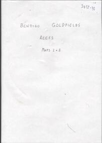
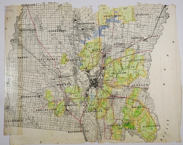
Map - BENDIGO GOLDFIELDS REEFS. MAPS 2 & 3
... BENDIGO GOLDFIELDS REEFS. MAPS 2 & 3....DVD. Bendigo Goldfields Reefs, Maps 2 & 3....Bendigo Goldfields Reefs DVD. Bendigo Goldfields Reefs, Maps 2 & 3. Map BENDIGO GOLDFIELDS REEFS. ...DVD. Bendigo Goldfields Reefs, Maps 2 & 3.bendigo, goldfields reefs -
 Bendigo Historical Society Inc.
Map - CAMPBELL COLLECTION: BENDIGO AND DISTRICT MAPS
... CAMPBELL COLLECTION: BENDIGO AND DISTRICT MAPS...MAP...Bendigo...Map. Bendigo & District. The same as 10104.1. The map is in a very damaged condition....MAP Bendigo allotments Map. Bendigo & District. ...Map. Bendigo & District. The same as 10104.1. The map is in a very damaged condition.map, bendigo, allotments -
Bendigo Historical Society Inc.
Map - CAMPBELL COLLECTION: BENDIGO & DISTRICT MAPS, 14-6-29
... CAMPBELL COLLECTION: BENDIGO & DISTRICT MAPS....MAP...Bendigo...History House 11 Mackenzie Street Bendigo goldfields MAP Bendigo agricultural lands H.A.Darby Map. ...Map. Eppalock, Sedgwick and Strathfieldsaye. Scale 20 chains to 1 inch. Total area 3972 acres. Prepared in W.P.B. from Assessment Plan and Parish Plans. H.A. Darby. (number 378 in map cupboard 1)H.A.Darbymap, bendigo, agricultural lands -
Bendigo Historical Society Inc.
Map - CAMPBELL COLLECTION: BENDIGO & DISTRICT MAPS, 2-2-29
... CAMPBELL COLLECTION: BENDIGO & DISTRICT MAPS....MAP...Bendigo...History House 11 Mackenzie Street Bendigo goldfields MAP Bendigo country lands W.J.Galbraith Map. ...Map. Wellsford, Parishes of Wellsford and Axedale. Scale 20 chains to 1 inch. Total area 4994 acres. Prepared in W.P.B. from A. and P. Plans by W.J.G. (number 377 in map cupboard 1)W.J.Galbraithmap, bendigo, country lands -
Bendigo Historical Society Inc.
Map - CAMPBELL COLLECTION: BENDIGO & DISTRICT MAPS, 16-5-29
... CAMPBELL COLLECTION: BENDIGO & DISTRICT MAPS....MAP...Bendigo...History House 11 Mackenzie Street Bendigo goldfields MAP Bendigo agricultural lands W.J.Galbraith Map. ...Map. Egerton, Parishes of Egerton and Whirrakee, scale 20 chains to 1 inch. Total area 5401 acres. Prepared in W.P.B. from A. and C.L. Plans by W.J. Galbraith (number 376 in map cupboard 1)W.J.Galbraithmap, bendigo, agricultural lands -
Bendigo Historical Society Inc.
Map - CAMPBELL COLLECTION: BENDIGO & DISTRICT MAPS
... CAMPBELL COLLECTION: BENDIGO & DISTRICT MAPS....MAP...Bendigo...Map. Lockwood, Parishes of Lockwood and Shelbourne. Scale 20 chains to 1 inch.Total area 4405 acres. Bullock Creek to the right, Spring Creek at Centre. Newbridge is 11 miles N E, To Marong, Bendigo...History House 11 Mackenzie Street Bendigo goldfields MAP Bendigo agricultural lands Map. ...Map. Lockwood, Parishes of Lockwood and Shelbourne. Scale 20 chains to 1 inch.Total area 4405 acres. Bullock Creek to the right, Spring Creek at Centre. Newbridge is 11 miles N E, To Marong, Bendigo Lockwood roads are on the left. (number 375 in map cupboard 1)map, bendigo, agricultural lands -
Bendigo Historical Society Inc.
Map - CAMPBELL COLLECTION: BENDIGO & DISTRICT MAPS, 5-4-28
... CAMPBELL COLLECTION: BENDIGO & DISTRICT MAPS....MAP...Bendigo...History House 11 Mackenzie Street Bendigo goldfields MAP Bendigo agricultural lands W.J.Galbraith Map. ...Map. Sedgwick, Parishes of Strathfieldsaye, Lyell and Sedgwick. Scale 20 chains to 1 inch.Total area 5372 acres. Prepared in W.P.B. from C.l. and A. Plans by W.J. Galbraith. (number 374 in map cupboard 1)W.J.Galbraithmap, bendigo, agricultural lands -
Bendigo Historical Society Inc.
Map - CAMPBELL COLLECTION: BENDIGO & DISTRICT MAPS, 22-3 29
... CAMPBELL COLLECTION: BENDIGO & DISTRICT MAPS....MAP...Bendigo...History House 11 Mackenzie Street Bendigo goldfields MAP Bendigo allotments G.W.L Map. ...Map. Marong, Parishes of Marong, Lockwood and Mandurang. Scale 20 chains to an inch. Total area 5106 acres. Crusoe Reservoir on right. Compiled in W.P.B. from Field Survey and Parish Plans (number 373 in map cupboard 1)G.W.Lmap, bendigo, allotments -
Bendigo Historical Society Inc.
Map - CAMPBELL COLLECTION: BENDIGO & DISTRICT MAPS
... CAMPBELL COLLECTION: BENDIGO & DISTRICT MAPS....MAP...Bendigo...History House 11 Mackenzie Street Bendigo goldfields MAP Bendigo country lands Map. copy. ...Map. copy. Raywood, Neilborough, Sebastian, Yarraberb, Woodvale. (number 372 in map cupboard 1)map, bendigo, country lands -
Bendigo Historical Society Inc.
Map - CAMPBELL COLLECTION: BENDIGO & DISTRICT MAPS, 21-8-1972
... CAMPBELL COLLECTION: BENDIGO & DISTRICT MAPS....MAP...Bendigo...Map. Strathfieldsaye. Locality Plan, Scale 1 inch, also marked are : Shire of Huntly, Shire of McIvor, Shire of Metcalfe, Shire of Maldon, Shire of Marong, City of Bendigo, Lake Eppalock, and various lanes and roads. ...History House 11 Mackenzie Street Bendigo goldfields MAP Bendigo rural M.Higgs Map. Strathfieldsaye. ...Map. Strathfieldsaye. Locality Plan, Scale 1 inch, also marked are : Shire of Huntly, Shire of McIvor, Shire of Metcalfe, Shire of Maldon, Shire of Marong, City of Bendigo, Lake Eppalock, and various lanes and roads. Mileage on some roads. (number 370 in map cupboard 1)M.Higgsmap, bendigo, rural -
Bendigo Historical Society Inc.
Map - CAMPBELL COLLECTION: BENDIGO AND DISTRICT MAPS, 2-2-29
... CAMPBELL COLLECTION: BENDIGO AND DISTRICT MAPS...MAP...Bendigo...Top left of map are directions to Fosterville, Huntly & Bendigo. (number 361 in map cupboard 1)...History House 11 Mackenzie Street Bendigo goldfields MAP Bendigo parish plan W.J.Galbraith Map. ...Map. Wellsford, Parishes of Wellsford and Axedale, Scale 20 chains to 1 inch. Total area 4994 acres. Prepared in W.P.B. from A and P Plans, by W.J.G.2-2-29. Top left of map are directions to Fosterville, Huntly & Bendigo. (number 361 in map cupboard 1)W.J.Galbraithmap, bendigo, parish plan -
Bendigo Historical Society Inc.
Map - CAMPBELL COLLECTION: BENDIGO AND DISTRICT MAPS
... CAMPBELL COLLECTION: BENDIGO AND DISTRICT MAPS....MAP...Bendigo...Map. Bendigo Whipstick Forest Park, 1:75,000, reserved forest and crown land, highway main road access forest tracks. ...History House 11 Mackenzie Street Bendigo goldfields MAP Bendigo country lands Map. Bendigo Whipstick Forest Park, 1:75,000, reserved forest and crown land, highway main road access forest tracks. ...Map. Bendigo Whipstick Forest Park, 1:75,000, reserved forest and crown land, highway main road access forest tracks. New Moon Mine, Elliot Dam, Nuggety Dam, Rogers Tree, Old Tom Mine, Blow Holes, Skylark Dam, Monument Rock, Hartland Eucalyptus Still and Dam, Hartland Eucalyptus Farm, Millwood Dam, Sandner Eucalyptus Still Site, Various unmarked dams. (number 391 in map cupboard 1)map, bendigo, country lands -
 Bendigo Historical Society Inc.
Map - CAMPBELL COLLECTION: BENDIGO AND DISTRICT MAPS
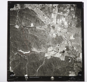
... CAMPBELL COLLECTION: BENDIGO AND DISTRICT MAPS...MAP...Bendigo...Crusoe Reservoir bottom right corner on Crusoe Road, shows Merindah Road running between Lockwood and Crusoe Roads. Map Name : Bendigo Mapsheet Run 2. 14-2-71, 13,200 A.S.L.. ...MAP Bendigo agricultural lands Map. Two aerial photographs of Kangaroo Flat and Lockwood (part). ...Map. Two aerial photographs of Kangaroo Flat and Lockwood (part). Crusoe Reservoir bottom right corner on Crusoe Road, shows Merindah Road running between Lockwood and Crusoe Roads. Map Name : Bendigo Mapsheet Run 2. 14-2-71, 13,200 A.S.L.. Map shown with NORTH at bottom of page, VIC 2479 at corner. Map 2 continues to the west. A joined copy of both photographs is also included.map, bendigo, agricultural lands -
Bendigo Historical Society Inc.
Map - CAMPBELL COLLECTION: BENDIGO AND DISTRICT MAPS
... CAMPBELL COLLECTION: BENDIGO AND DISTRICT MAPS...MAP...Bendigo...History House 11 Mackenzie Street Bendigo goldfields MAP Bendigo allotments Map. Eaglehawk, Parishes of Huntly and Nerring. ...Map. Eaglehawk, Parishes of Huntly and Nerring. Scale 20 chains to 1 inch. Total area 6211 acres, Bottom left is Eaglehawk Kerang Railway line. IN PENCIL Euc areas 1974, Laurie C.Raynor Comp 13,14,15. J & T Pierce 1,9,8. The use of sticky tape on joins. Sand heaps from Moon Mine. (number 369 in map cupboard 1)map, bendigo, allotments -
Bendigo Historical Society Inc.
Map - CAMPBELL COLLECTION: BENDIGO AND DISTRICT MAPS, 11-4-29
... CAMPBELL COLLECTION: BENDIGO AND DISTRICT MAPS...MAP...Bendigo...History House 11 Mackenzie Street Bendigo goldfields MAP Bendigo allotments W.J.Galbraith Map. ...Map. Huntly, Parishes of Huntly, Nerring and Neilborough. Scale 20 chains to 1 inch. Total area 4738 acres. Prepared in W.P.B. from A and C.L. Plans by W.J. Galbraith 11-4-29. Eaglehawk. IN PENCIL top right of map: Euc areas 1974 Scott & Cole Comp 5,6,7,8,9,12,13. Laurie C.Raynor 10,11,17, Part 16 South of Scotsmans Track, J.T Pierce 14,15,16 North of Scotsman Track. From Neilborough. G.Ward. A.Sloan. K.Walker at bottom of map. (number 368 in map cupboard 1)W.J.Galbraithmap, bendigo, allotments -
Bendigo Historical Society Inc.
Map - CAMPBELL COLLECTION: BENDIGO AND DISTRICT MAPS, 8-7-29
... CAMPBELL COLLECTION: BENDIGO AND DISTRICT MAPS...MAP...Bendigo...Bendigo 3 miles. Compiled in W.P.D. from Assessment and Parish Plans by H.A.D 8-7- 29 (number 367 in map cupboard 1)...History House 11 Mackenzie Street Bendigo goldfields MAP Bendigo allotments H.A.D.(H.A.Darby) Map. ...Map. Rifle Range, Parishes of Wellsford and Sandhurst. Scale 20 chains to 1 inch. Total area by Planimeter 5916 acres. Wallan and Bendigo Railway line. Rifle Range. Axedale township and station 8 miles. To Longlea Ryl station 2 1/2 miles. To Epsom 1 1/2 miles. To Bendigo 3 miles. Compiled in W.P.D. from Assessment and Parish Plans by H.A.D 8-7- 29 (number 367 in map cupboard 1)H.A.D.(H.A.Darby)map, bendigo, allotments -
Bendigo Historical Society Inc.
Map - CAMPBELL COLLECTION: BENDIGO AND DISTRICT MAPS, 16-5-29
... CAMPBELL COLLECTION: BENDIGO AND DISTRICT MAPS...MAP...Bendigo...History House 11 Mackenzie Street Bendigo goldfields MAP Bendigo allotments W.J.G.(W.J.Galbraith) Map. ...Map. Egerton, Parishes of Egerton and Whirrakee. Scale 20 chains to 1 inch. Total area 5401 acres. Prepared in W.P.B. from A. and C.L. Plans by W.J.G. 16-5-29. To Rochester 12 miles. (number 366 in map cupboard 1)W.J.G.(W.J.Galbraith)map, bendigo, allotments -
Bendigo Historical Society Inc.
Map - CAMPBELL COLLECTION: BENDIGO AND DISTRICT MAPS
... CAMPBELL COLLECTION: BENDIGO AND DISTRICT MAPS...MAP...Bendigo...History House 11 Mackenzie Street Bendigo goldfields MAP Bendigo allotments Map. Kimbolton, Parishes of Kimbolton and Lyell, scale 20 chains to 1 inch. ...Map. Kimbolton, Parishes of Kimbolton and Lyell, scale 20 chains to 1 inch. Area by Planimeter 6258 acres. Knowsley. 10 1/2 miles to Strathfieldsaye. Campaspe River at bottom right of map. (number 365 in map cupboard 1)map, bendigo, allotments -
Bendigo Historical Society Inc.
Map - CAMPBELL COLLECTION: BENDIGO AND DISTRICT MAPS, 16-4-29
... CAMPBELL COLLECTION: BENDIGO AND DISTRICT MAPS...MAP...Bendigo...Map. Kennington, Parishes of Sandhurst, Mandurang and Strathfieldsaye. Scale 20 chains to 1 inch. Total area 2918 acres. Bendigo...History House 11 Mackenzie Street Bendigo goldfields MAP Bendigo allotments W.J.Galbraith Map. ...Map. Kennington, Parishes of Sandhurst, Mandurang and Strathfieldsaye. Scale 20 chains to 1 inch. Total area 2918 acres. Bendigo 2 1/2 miles. Prepared in W.B. from A.and C. L. Plans by W.J. Galbraith, 16-4-29. (number 364 in map cupboard 1)W.J.Galbraithmap, bendigo, allotments -
Bendigo Historical Society Inc.
Map - CAMPBELL COLLECTION: BENDIGO AND DISTRICT MAPS
... CAMPBELL COLLECTION: BENDIGO AND DISTRICT MAPS...MAP...Bendigo...History House 11 Mackenzie Street Bendigo goldfields MAP Bendigo allotments Map. Mandurang, Parish of Mandurang, Scale 20 chains to 1 inch. ...Map. Mandurang, Parish of Mandurang, Scale 20 chains to 1 inch. Total area 5993 acres, Northern Railway to left of map, Water Reserve (Spring Gully). (number 363 in map cupboard 1)map, bendigo, allotments -
Bendigo Historical Society Inc.
Map - CAMPBELL COLLECTION: BENDIGO AND DISTRICT MAPS
... CAMPBELL COLLECTION: BENDIGO AND DISTRICT MAPS...MAP...Bendigo...History House 11 Mackenzie Street Bendigo goldfields MAP Bendigo parish plan Map. Marong, Parishes of Marong, Lockwood and Mandurang. ...Map. Marong, Parishes of Marong, Lockwood and Mandurang. Scale 20 chains to an inch. Total 5106 acres. Compiled in W.P.B. from Field Survey and Parish Plans. Crusoe Reservoir to the right of map. (number 362 in map cupboard 1)map, bendigo, parish plan -
Bendigo Historical Society Inc.
Map - CAMPBELL COLLECTION: BENDIGO AND DISTRICT MAPS
... CAMPBELL COLLECTION: BENDIGO AND DISTRICT MAPS...MAP...Bendigo...History House 11 Mackenzie Street Bendigo goldfields MAP Bendigo agricultural lands Map. ...Map. Sedgwick. Continuation of 10104.13. (number 360 in map cupboard 1)map, bendigo, agricultural lands -
Bendigo Historical Society Inc.
Map - CAMPBELL COLLECTION: BENDIGO AND DISTRICT MAPS
... CAMPBELL COLLECTION: BENDIGO AND DISTRICT MAPS...MAP...Bendigo...History House 11 Mackenzie Street Bendigo goldfields MAP Bendigo agricultural lands Map. ...Map. Sedgwick. Parishes of Strathfieldsaye, Lyell and Sedgwick. Scale 20 chains to 1 inch. (number 359 in map cupboard 1)map, bendigo, agricultural lands -
Bendigo Historical Society Inc.
Map - CAMPBELL COLLECTION: BENDIGO AND DISTRICT MAPS
... CAMPBELL COLLECTION: BENDIGO AND DISTRICT MAPS...MAP...Bendigo...History House 11 Mackenzie Street Bendigo goldfields MAP Bendigo allotments Map. Lockwood, Parishes of Lockwood and Shelbourne, scale 20 chains to 1 inch. ...Map. Lockwood, Parishes of Lockwood and Shelbourne, scale 20 chains to 1 inch. Spring Creek centre of map and Bullock Creek to the right. Total area 4405 acres. (number 358 in map cupboard 1)map, bendigo, allotments -
Bendigo Historical Society Inc.
Map - CAMPBELL COLLECTION: BENDIGO AND DISTRICT MAPS
... CAMPBELL COLLECTION: BENDIGO AND DISTRICT MAPS...MAP...Bendigo...Map. Eppalock, Sedgwick and Strathfieldsaye, scale 20 chains to 1 inch. Road to Bendigo 13 1/2 miles at top right of map, Longlea Railway Station 5 1/2 miles, Bendigo 11 miles, Strathfieldsaye 5 miles on left of map. ...History House 11 Mackenzie Street Bendigo goldfields MAP Bendigo agricultural lands H.A.Darby Map. ...Map. Eppalock, Sedgwick and Strathfieldsaye, scale 20 chains to 1 inch. Road to Bendigo 13 1/2 miles at top right of map, Longlea Railway Station 5 1/2 miles, Bendigo 11 miles, Strathfieldsaye 5 miles on left of map. Total area 3972 acres. Prepared in W.P.B. from Assessment Plan and Parish Plans. H.A. Darby 14-6-29.H.A.Darbymap, bendigo, agricultural lands -
Bendigo Historical Society Inc.
Map - CAMPBELL COLLECTION: BENDIGO AND DISTRICT MAPS, 15-2-29
... CAMPBELL COLLECTION: BENDIGO AND DISTRICT MAPS...MAP...Bendigo...History House 11 Mackenzie Street Bendigo goldfields MAP Bendigo parish plan W.J.Galbraith Map. ...Map. Nerring, Parish of Nerring, scale 20 chains to 1 inch. Prepared in W.J.B. from A and B plans by W.J. Galbraith 15-2-29. (number 356 in map cupboard 1)W.J.Galbraithmap, bendigo, parish plan -
Bendigo Historical Society Inc.
Map - CAMPBELL COLLECTION: BENDIGO AND DISTRICT MAPS
... CAMPBELL COLLECTION: BENDIGO AND DISTRICT MAPS...MAP...Bendigo...Map. Ascot Unit, scale 20 chains to an inch, arrow pointing to magnetic north, road to Fosterville to the East, Huntly 3/4 mile to the West, road to Epsom 3/4 mile and road to Bendigo 4 1/2 miles south west on map, also on page is the Northern Railway (Bendigo to Echuca) line. ...History House 11 Mackenzie Street Bendigo goldfields MAP Bendigo country lands Map. Ascot Unit, scale 20 chains to an inch, arrow pointing to magnetic north, road to Fosterville to the East, Huntly 3/4 mile to the West, road to Epsom 3/4 mile and road to Bendigo 4 1/2 miles south west on map, also on page is the Northern Railway (Bendigo to Echuca) line. ...Map. Ascot Unit, scale 20 chains to an inch, arrow pointing to magnetic north, road to Fosterville to the East, Huntly 3/4 mile to the West, road to Epsom 3/4 mile and road to Bendigo 4 1/2 miles south west on map, also on page is the Northern Railway (Bendigo to Echuca) line. (number 355 in map cupboard 1)map, bendigo, country lands -
Bendigo Historical Society Inc.
Map - CAMPBELL COLLECTION: BENDIGO AND DISTRICT MAPS
... CAMPBELL COLLECTION: BENDIGO AND DISTRICT MAPS...MAP...Bendigo...History House 11 Mackenzie Street Bendigo goldfields MAP Bendigo agricultural lands Map. ...Map. Ellesmere, Parish of Ellesmere. Scale 20 chains to 1 inch. Total area 3926 acres. Prepared in W.P.B. from A and P plans. (number 354 in map cupboard 1)map, bendigo, agricultural lands -
Bendigo Historical Society Inc.
Map - CAMPBELL COLLECTION: BENDIGO AND DISTRICT MAPS, 8-2-29
... CAMPBELL COLLECTION: BENDIGO AND DISTRICT MAPS...MAP...Bendigo...History House 11 Mackenzie Street Bendigo goldfields MAP Bendigo agricultural lands W.J.Galbraith Map. ...Map. Bagshot, Parishes of Wellsford, Ellesmere and Bagshot. Scale 20 chains to 1 inch. Total area 5037 acres. Prepared in W.P.B. from A.C.l. and D.B. Plans, W.J. Galbraith, 8-2-29 (number 353 in map cupboard 1)W.J.Galbraithmap, bendigo, agricultural lands