Warrnambool and District Historical Society Inc.
Map - Maps, Soldiers Settlement WW2, Circa 1950
... ...berrambool...The maps are as follows:
.1 Narrapumelap Estate ( Ripon & Hampden)
.2 Narrapumelap Estate Part 2 (Villers & Ripon)
.3 Narrapumelap Estate Part 3 ( Villiers & Ripon)
.4 Burrumbeet Estate ( Ripon)
.5 ' Berrambool' Estate 9 Hampden & Villiers)
.6 ' Hopkins Hill' Estate Villiers 4011 acres
.7 Caramut North No 2 Estate ( Villiers )
.8 ' Morpor' Estate ( Villiers) 4172 acres
.9 ' Morgiana' Estate ( Normandy) 3453 acres
.10 ' Chatsworth House' ( Villiers) 9341 Acres
.11 ' East Elwood' Estate Villiers 2407 acres
.12 Grey's Estate ( Mornington) 1151acres
.13 ' Rowes Estate' ( Buln Buln Gippsland 733 acres
.14 'Tarrone' Estate No 2 Part map
.15 'Chaldon Meade' Estate (Bourke) Bulla 517 acres
.16 ' Terranallum South' Estate Hampden 3757 acres
.17 ' Brung Brungle' Estate Dundas 695
.18 ' Armidale ' Estate ( Dundas)2108 acres
.19 ' Moyne Falls' Estate ( Villiers) 627 acres
.20' Yulong' Estate 9 Lowan 6321 acres
.21 Murray Valley Irrigation District 9 Moira)113 acres
.22 Murray Valley Irrigation District 103 acres
.23 ' Mount Fyans' Estate ( Hampden)
.24 ' Barwidgee ' Estate ( Villiers) 4277 acres
.25 'Pine Hills' Estate 2nd portion ( Lowan) 6190 acres
...As such they have historic and social interest and significance. narrapumelap berrambool hopkins hill caramut north morpor chatsworth house east elwood terrinallum moyne falls tarrone caramut soldiers settlers Burrumbeet morgiana grey's estate mornington chaldon meade brung brungle The maps are as follows:
.1 Narrapumelap Estate ( Ripon & Hampden)
.2 Narrapumelap Estate Part 2 (Villers & Ripon)
.3 Narrapumelap Estate Part 3 ( Villiers & Ripon)
.4 Burrumbeet Estate ( Ripon)
.5 ' Berrambool' Estate 9 Hampden & Villiers)
.6 ' Hopkins Hill' Estate Villiers 4011 acres
.7 Caramut North No 2 Estate ( Villiers )
.8 ' Morpor' Estate ( Villiers) 4172 acres
.9 ' Morgiana' Estate ( Normandy) 3453 acres
.10 ' Chatsworth House' ( Villiers) 9341 Acres
.11 ' East Elwood' Estate Villiers 2407 acres
.12 Grey's Estate ( Mornington) 1151acres
.13 ' Rowes Estate' ( Buln Buln Gippsland 733 acres
.14 'Tarrone' Estate No 2 Part map
.15 'Chaldon Meade' Estate (Bourke) Bulla 517 acres
.16 ' Terranallum South' Estate Hampden 3757 acres
.17 ' Brung Brungle' Estate Dundas 695
.18 ' Armidale ' Estate ( Dundas)2108 acres
.19 ' Moyne Falls' Estate ( Villiers) 627 acres
.20' Yulong' Estate 9 Lowan 6321 acres
.21 Murray Valley Irrigation District 9 Moira)113 acres
.22 Murray Valley Irrigation District 103 acres
.23 ' Mount Fyans' Estate ( Hampden)
.24 ' Barwidgee ' Estate ( Villiers) 4277 acres
.25 'Pine Hills' Estate 2nd portion ( Lowan) 6190 acres A collection of 25 paper maps which relate to to the soldiers settlement post World War 2. ...
The soldiers' settlement scheme operated after the first and second world wars in an effort to more closely settle the land and also give opportunities to returned soldiers. Crown land and other larger estates were acquired for the purpose. Most of these maps relate to the area north of Warrnambool where many of the subdivisions were parts of larger estates.These maps pertaining to the Soldiers' Settlement program, relate to an interesting part of Australian and local history. As such they have historic and social interest and significance.A collection of 25 paper maps which relate to to the soldiers settlement post World War 2. Some have details of the people allocated the land and some smaller maps have the printed details of the applicants requirements.Text is black on white paper which in some cases is quite aged. The maps are as follows:
.1 Narrapumelap Estate ( Ripon & Hampden)
.2 Narrapumelap Estate Part 2 (Villers & Ripon)
.3 Narrapumelap Estate Part 3 ( Villiers & Ripon)
.4 Burrumbeet Estate ( Ripon)
.5 ' Berrambool' Estate 9 Hampden & Villiers)
.6 ' Hopkins Hill' Estate Villiers 4011 acres
.7 Caramut North No 2 Estate ( Villiers )
.8 ' Morpor' Estate ( Villiers) 4172 acres
.9 ' Morgiana' Estate ( Normandy) 3453 acres
.10 ' Chatsworth House' ( Villiers) 9341 Acres
.11 ' East Elwood' Estate Villiers 2407 acres
.12 Grey's Estate ( Mornington) 1151acres
.13 ' Rowes Estate' ( Buln Buln Gippsland 733 acres
.14 'Tarrone' Estate No 2 Part map
.15 'Chaldon Meade' Estate (Bourke) Bulla 517 acres
.16 ' Terranallum South' Estate Hampden 3757 acres
.17 ' Brung Brungle' Estate Dundas 695
.18 ' Armidale ' Estate ( Dundas)2108 acres
.19 ' Moyne Falls' Estate ( Villiers) 627 acres
.20' Yulong' Estate 9 Lowan 6321 acres
.21 Murray Valley Irrigation District 9 Moira)113 acres
.22 Murray Valley Irrigation District 103 acres
.23 ' Mount Fyans' Estate ( Hampden)
.24 ' Barwidgee ' Estate ( Villiers) 4277 acres
.25 'Pine Hills' Estate 2nd portion ( Lowan) 6190 acres
narrapumelap, berrambool, hopkins hill, caramut north, morpor, chatsworth house, east elwood, terrinallum, moyne falls, tarrone, caramut soldiers settlers, burrumbeet, morgiana, grey's estate mornington, chaldon meade, brung brungle
 Warrnambool and District Historical Society Inc.
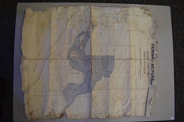 Warrnambool and District Historical Society Inc.