Showing 9 items matching "beswicke "
-
 Dandenong & District Historical Society
Beswicke Family, Beswicke Family - Biography & Some Family History
... Beswicke Family - Biography & Some Family History...Beswicke...Beswicke Family - Biography & Some Family History...Beswicke Family - Biography & Some Family History...Dandenong & District Historical Society 1st Floor, 39 Clow Street Dandenong melbourne Beswicke Family - Biography & Some Family History Architect Beswicke Charles Beswicke James Beswicke James Lomax Beswicke John Beswicke John Beswicke Architect Beswicke Family - Biography & Some Family History Beswicke Family - Biography & Some Family History Beswicke Family ...Beswicke Family - Biography & Some Family HistoryArchitectbeswicke, charles beswicke, james beswicke, james lomax beswicke, john beswicke, john beswicke architect -
 Canterbury History Group
Book, K. C. B. Bethell, John Beswicke 1847-1925: Heritage Architect
... John Beswicke 1847-1925: Heritage Architect...Beswicke designed buildings in and around Melbourne ... ..."John Beswicke was a prolific architect during the Victorian and Edwardian eras. He commenced as an architect 13 years after a competition was called for the design of the first Government House in Victoria, and 10 years after the Victorian Institute of Architects was formed. The majority of Beswicke's designs were built before Federation in 1901. ... Beswicke designed buildings in and around Melbourne ... A dapper and urbane gentleman, he was a keen sporting shooter, motoring enthusiest and inventor, as well as a devoted family man. ... This book cements Beswicke's place as one of Melbourne's formost architects of his era."--Dust jacket gate fold.150 pages. Includes photographs, bibliographical references and indexes of book and architectural worknon-fiction"John Beswicke was a prolific architect during the Victorian and Edwardian eras. He commenced as an architect 13 years after a competition was called for the design of the first Government House in Victoria, and 10 years after the Victorian Institute of Architects was formed. The majority of Beswicke's designs were built before Federation in 1901. ... Beswicke designed buildings in and around Melbourne ... A dapper and urbane gentleman, he was a keen sporting shooter, motoring enthusiest and inventor, as well as a devoted family man. ... This book cements Beswicke's place as one of Melbourne's formost architects of his era."--Dust jacket gate fold.architects, heritage studies, buildings - victoria, biographies, john beswicke -
 Kew Historical Society Inc
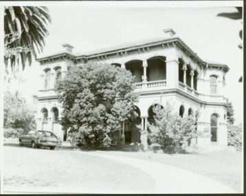
Photograph - 'Mandalay', 3 Molesworth Street (Kew), 1979
... The similarity of these buildings and the fact that Beswicke and Coote called tenders for a house in Molesworth Street, both suggest that this house was also by that firm....The similarity of these buildings and the fact that Beswicke and Coote called tenders for a house in Molesworth Street, both suggest that this house was also by that firm. ...'Mandalay' at 3 Molesworth Street, Kew was originally named 'Kaikoura'. Pru Sanderson's 'Kew Urban Conservation Study' (1988) describes the house as: "The first documentary evidence of this property records that William Dawson was the original owner and occupier of this substantial two-storey mansion, built at the outset of the economic depression of the 1890s. Having an initial N.A.V. of £120 4, the house was occupied by Dawson until at least 1904. This two-storeyed rendered house is Italianate in styling and is dominated by a two-storeyed loggia that spans two facades. At ground floor level it is supported on coupled cast iron colonettes and above has single colonettes that support stilted segmental arches. The house is quite typical of its time, however it bears a strong resemblance to 39 Sackville Street probably by Beswicke and Coote (q.v.), and 'Kawarau'.in Hawthorn, designed by Coote. The similarity of these buildings and the fact that Beswicke and Coote called tenders for a house in Molesworth Street, both suggest that this house was also by that firm.Large original, black and white print positive photograph of 3 Molesworth Street, Kew The two storey Italianate mansion has a double loggia and two bay windows on the side of the property. A car is parked in front.manadaly - molesworth street (kew), historic houses -- kew, italianate architecture -- kew (vic.), kaikoura -- molesworth street -- kew (vic.), beswicke & coote -
 St Kilda Historical Society
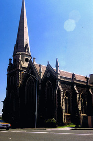
Photograph, St Kilda Presbyterian Church exterior - images collection, c 1970s
... Charles Beswicke had toured Britain and the Continent in 1886 armed with a camera and returned to Australia with photographs of what he considered the greatest examples of architecture. ...Charles Beswicke had toured Britain and the Continent in 1886 armed with a camera and returned to Australia with photographs of what he considered the greatest examples of architecture. ...The St Kilda Presbyterian Church is now part of the St Kilda & Balaclava Presbyterian Church. Its first service was inaugurated by the Free Church Synod of Victoria in May 1855, in a building at the corner of High Street and Alma Road. In October 1855 the congregation moved to a wooden building in Inkerman Street, purchased from the Independent (Congregational) Church. The present church site was purchased and the first church opened in 1860. The foundation stone for the present church building, the second to be built on the site, was laid by the Governor of Victoria, Sir Henry Brougham Loch, on 27 January 1885. The building was opened on 30 May 1886. Wilson and Beswicke were the architects. Ralph Wilson designed the Methodist church on the corner of Princes and Fitzroy Streets and lived diagonally opposite the Presbyterian church. Charles Beswicke had toured Britain and the Continent in 1886 armed with a camera and returned to Australia with photographs of what he considered the greatest examples of architecture. He was responsible for the town halls in Brighton, Malvern, Hawthorn and Essendon and Wesleyan churches in Camberwell and Dandenong. Thomas Corley was the builder. The lofty spire was ‘a landmark to the mariner’ used by sea captains sailing up Port Phillip Bay. On a prominent position, the highest point in St Kilda, the church attracted wealthy people with legal, merchant and pastoral backgrounds.colour photographst kilda, churches, presbyterian church, balaclava -
 Kew Historical Society Inc
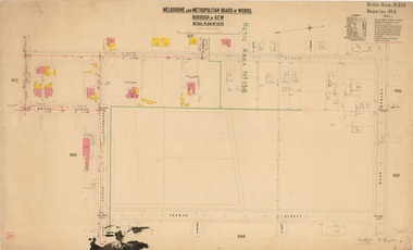
Plan, Melbourne & Metropolitan Board of Works : Borough of Kew : Detail Plan No.1570, 1905
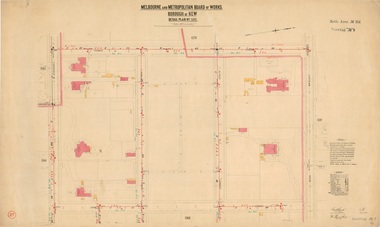
... Kylemore is one of the few houses in Kew designed by John Beswicke. The most notable owner of Kylemore was William Whitehead, who owned the house between 1895 and 1900. ...Kylemore is one of the few houses in Kew designed by John Beswicke. The most notable owner of Kylemore was William Whitehead, who owned the house between 1895 and 1900. ...The Melbourne and Metropolitan Board of Works (MMBW) plans were produced from the 1890s to the 1950s. They were crucial to the design and development of Melbourne's sewerage and drainage system. The plans, at a scale of 40 feet to 1 inch (1:480), provide a detailed historical record of Melbourne streetscapes and environmental features. Each plan covers one or two street blocks (roughly six streets), showing details of buildings, including garden layouts and ownership boundaries, and features such as laneways, drains, bridges, parks, municipal boundaries and other prominent landmarks as they existed at the time each plan was produced. (Source: State Library of Victoria)This plan forms part of a large group of MMBW plans and maps that was donated to the Society by the Mr Poulter, City Engineer of the City of Kew in 1989. Within this collection, thirty-five hand-coloured plans, backed with linen, are of statewide significance as they include annotations that provide details of construction materials used in buildings in the first decade of the 20th century as well as additional information about land ownership and usage. The copies in the Public Record Office Victoria and the State Library of Victoria are monochrome versions which do not denote building materials so that the maps in this collection are invaluable and unique tools for researchers and heritage consultants. A number of the plans are not held in the collection of the State Library of Victoria so they have the additional attribute of rarity.Original survey plan, issued by the MMBW to a contractor with responsibility for constructing sewers in the area identified on the plan within the Borough of Kew. The plan was at some stage hand-coloured, possibly by the contractor, but more likely by officers working in the Engineering Department of the Borough and later Town, then City of Kew. The hand-coloured sections of buildings on the plan were used to denote masonry or brick constructions (pink), weatherboard constructions (yellow), and public buildings (grey). Plan No.1570 shows the layout of gardens and houses in Sackville Street, Davis Street, Wrixon Street, and Fitzwilliam Street in 1904. While Thomas Street is included on the map, at this stage no houses had been built. The plan identifies two named houses: ‘Fairview’ and ‘Kylemore’. Fairview is more fully delineated in Plan No.1563. Kylemore is one of the few houses in Kew designed by John Beswicke. The most notable owner of Kylemore was William Whitehead, who owned the house between 1895 and 1900. In 1894, Australian newspapers reported the marriage of Whitehead’s daughter to Dr. Gerald Eugene Cussen, the brother of Sir Leo Cussen, the Supreme Court Judge. The married couple was to live at ‘Wilton’ (now the Kew RSL) from 1911-15.melbourne and metropolitan board of works, detail plans, mmbw 1570, cartography -
 Kew Historical Society Inc
Plan, Melbourne & Metropolitan Board of Works : Borough of Kew : Detail Plan No.1569, 1905
... ‘Heathfield’ was built in 1888 for Henry Eeles, and was one of many fine homes in Kew, Hawthorn and surrounding suburbs designed by prolific architect John Beswicke; it later became “La Verna” and was a Franciscan monastery. ...‘Heathfield’ was built in 1888 for Henry Eeles, and was one of many fine homes in Kew, Hawthorn and surrounding suburbs designed by prolific architect John Beswicke; it later became “La Verna” and was a Franciscan monastery. ...The Melbourne and Metropolitan Board of Works (MMBW) plans were produced from the 1890s to the 1950s. They were crucial to the design and development of Melbourne's sewerage and drainage system. The plans, at a scale of 40 feet to 1 inch (1:480), provide a detailed historical record of Melbourne streetscapes and environmental features. Each plan covers one or two street blocks (roughly six streets), showing details of buildings, including garden layouts and ownership boundaries, and features such as laneways, drains, bridges, parks, municipal boundaries and other prominent landmarks as they existed at the time each plan was produced. (Source: State Library of Victoria)This plan forms part of a large group of MMBW plans and maps that was donated to the Society by the Mr Poulter, City Engineer of the City of Kew in 1989. Within this collection, thirty-five hand-coloured plans, backed with linen, are of statewide significance as they include annotations that provide details of construction materials used in buildings in the first decade of the 20th century as well as additional information about land ownership and usage. The copies in the Public Record Office Victoria and the State Library of Victoria are monochrome versions which do not denote building materials so that the maps in this collection are invaluable and unique tools for researchers and heritage consultants. A number of the plans are not held in the collection of the State Library of Victoria so they have the additional attribute of rarity.Original survey plan, issued by the MMBW to a contractor with responsibility for constructing sewers in the area identified on the plan within the Borough of Kew. The plan was at some stage hand-coloured, possibly by the contractor, but more likely by officers working in the Engineering Department of the Borough and later Town, then City of Kew. The hand-coloured sections of buildings on the plan were used to denote masonry or brick constructions (pink), weatherboard constructions (yellow), and public buildings (grey). This plan covers parts of Sackville Street, John Street, Thomas Street and Cotham Road, and includes several very large houses in Sackville Street. Job Smith built ‘Berrington’ in about 1888-90 for himself, and ‘Pomeroy’ (now ‘Merridale’) in 1885 for James Mickleburgh. ‘Heathfield’ was built in 1888 for Henry Eeles, and was one of many fine homes in Kew, Hawthorn and surrounding suburbs designed by prolific architect John Beswicke; it later became “La Verna” and was a Franciscan monastery. Similarly, in Cotham Road, we can see ‘Bella Vista’ (now demolished), and ‘Charleville’, with its double-storeyed arcade frontage, built in 1889 for Charles Donaldson whose family occupied it until 1939. This was renamed ‘Ross House’ by the second owner, Dr. Thomas King, and then substantially restored in the 1960s by the Stillwell family, well known as car drivers and dealers. Bella Vista (later ‘Malinda’) was originally designed by the architect Robert Haddon and built for Abel Hoadley, inventor of the Violet Crumble Bar and many other delicious delicacies. He began by manufacturing jams and pickles in South Melbourne using fruit from his own orchard in East Burwood.melbourne and metropolitan board of works, detail plans, mmbw 1569, cartography -
Canterbury History Group
Document - Houses "Cullymont" "Eyre Court", 1990
... Canterbury History Group 190A Canterbury Road Canterbury melbourne Canterbury Cullymont Molesworth Street Historic Buildings Council Eyre Court Houses John Beswicke Material relating to "Cullymont"/ "Eyre Court" 2 Molesworth Street prepared in relation to Historic Buildings Council investigation 1990 Document Houses "Cullymont" "Eyre Court" ...Material relating to "Cullymont"/ "Eyre Court" 2 Molesworth Street prepared in relation to Historic Buildings Council investigation 1990canterbury, cullymont, molesworth street, historic buildings council, eyre court, houses, john beswicke -
Canterbury History Group
Book, Gwen McWilliam, Boroondara Musing
... Canterbury History Group 190A Canterbury Road Canterbury melbourne Boroondara Schools Churches Howitt> Richard Campbell> Dame Kate Shrublands McGregor Street Bonwick> James Watson> John Middleton John Beswicke John Maling Book one of a collection of articles by Gwen McWilliam published in the Progress Leader from 1990-1993 104 pages; includes many colour photos Boroondara Musing Book Gwen McWilliam Tanner, Steve; Campan, Valeriu; Payne, Steve and McWilliam, Ian ...Book one of a collection of articles by Gwen McWilliam published in the Progress Leader from 1990-1993104 pages; includes many colour photosBook one of a collection of articles by Gwen McWilliam published in the Progress Leader from 1990-1993boroondara, schools, churches, howitt> richard, campbell> dame kate, shrublands, mcgregor street, bonwick> james, watson> john middleton, john beswicke, john maling -
Canterbury History Group
Article, The best in the street
... Canterbury History Group 190A Canterbury Road Canterbury melbourne Canterbury Molesworth Street "Cullymont" McCully Family Houses John Beswicke Real estate advertisement for the auction on 20 November 1999, of "Cullymont" 2 Molesworth Street Canterbury, built in 1889 as a country retreat. ...Real estate advertisement for the auction on 20 November 1999, of "Cullymont" 2 Molesworth Street Canterbury, built in 1889 as a country retreat. Includes coloured photographs of the interior and exterior.canterbury, molesworth street, "cullymont", mccully family, houses, john beswicke