Showing 1906 items matching black range
-
 Marysville & District Historical Society
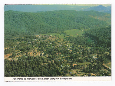
Postcard (item) - Colour postcard, K. & H. Ellis, Panorama of Marysville with Black Range in background, Pre 2009
... Panorama of Marysville with Black Range in background....Panorama of Marysville with Black Range in background... Postcard Panorama of Marysville with Black Range in background ...A colour photograph of a view of Marysville in Victoria.A colour photograph of a view of Marysville in Victoria. The photograph has been taken from one of the many lookouts that surround Marysville.Panorama of Marysville with Black Range in background. Colorscans MARYSVILLE - VICTORIA Panorama of Marysville with Black/ Range in background. c PUBLISHED & PRINTED BY COLORSCAPES PUBLISHING PTY LTD 118-120 BRIGHTON STREET RICHMOND 3121 Supa-vu/ cards Photographed and Distributed by:/ K. & H. ELLIS - 35 Old Warburton Road/ Warburton 3799 20-1-81/ Dear Mum/ Just a line/ to let you know we/ have settled in here./ Its a nice park not to/ big, with a river in/ behind the van. (its/ more like a swift/ running creek, the/ kids are really enjoying/ it. There are plenty of/ walks to go on, up here/ tracks everywhere./ Hows the cooler going/ keeping you cool?/ We are able to say here until/ Sunday./ See you Mum/ Love Lois, Tom,/ & Kids. Mrs A. McTaggart/ 2 Frederick Street/ Kyabram Vic/ 3620. On reverse of postcard are 5 black marks; one in each corner and one in the centre from where the postcard has been removed from an album.marysville, victoria, postcard, souvenir, k & h ellis, colorscans publishing -
 Federation University Historical Collection
Reports, Big Cats Sightings and Stock Kills 2000-2011, 2000-2011
... black range... binginnwarri dawson the springs mt taylor black range driffield west ...The folder or correspondence is the result of a Freedom of Informaition request made to the Department of Primary Industries in 2011. The folder was collected for research being conducted by David Waldron.Folder of reports of Big Cat by rangers. australian mythical animals collection, david waldron, department of primary industries, rangers, peter walsh, warragul creek, binginwarri, coongulla, straford, licola, blanket hill, darramin, blanket hill, woodside beach, heyfield, puma, panther, cowwarr, glenmaggie, bolands bluff, darrimen, bolands bluff, binginnwarri, dawson, the springs, mt taylor, black range, driffield west, snowy plains airstrip, glenmaggie north, jack smith lake, munro, briagaling, dutson downs, connors plain, giffard west, darriment, joyces road junction, giffard west, wallaby creek, south gippsland highway, avon river, orbost, four mile creek -
Stawell Historical Society Inc
Memorabilia - Realia, c1860's-1880's
... White Clay Pipe Bowl found in Black Range... grampians Realia Memorabilia White Clay Pipe Bowl found in Black ...White Clay Pipe Bowl found in Black Rangestawell -
Stawell Historical Society Inc
Map, Department of Mines Victoria, Alluvial Map Stawell Region, 1870's
... c1870 Coloured map showing Black Range North to Stawell... Black Range North to Stawell and Illawarra. Shows geological ...c1870 Coloured map showing Black Range North to Stawell and Illawarra. Shows geological layout.Department Mines Victoria 1952/G/2 mining, gold, map -
Marysville & District Historical Society
Article (item) - Book Extract, Aboriginal History, Unknown
... dividing range black spur watts river badger creek healesville ...An extract from a book regarding a brief history of the Kulin nation of the North Central district of Victoria.An extract from a book regarding a brief history of the Kulin nation of the North Central district of Victoria. This history covered is both prior to European history and post-European history. The extract also covers current (1991) status of Aboriginal affairs and European settlement of the area.kulin nation, woiworung, taungurong, bunurong, watherong, jajowrong, wurrundjeri-willam, waring-ilam-balluk, goulburn valley, acheron valley, upper goulburn district, eildon-thornton, eildon homestead, o'rourke, thornton, assistant protector thomas, yarra valley, kilmore, mount william, jt gellibrand, william buckley, major mitchell, port phillip, murray river, yorta yorta, yowung-illam-balluk, waring-illam-balluk, ngurai-illam-wurrung, kurnai nation, protectorate system, victoria, george robinson, chief protector, willam thomas, james dredge, edward parker, charles sievewright, central board for the protection of aborigines, presbyterian mission, anglican mission, moravian mission, wonga, munnarin, beaning, murrin murrin, parugean, baruppin, koo-gurrin, acheron river, little river, acheron run, peter snodgrass, stephen jones, barak, dividing range, black spur, watts river, badger creek, healesville, coranderrk, victorian christmas bush, aboriginal and torres strait islander heritage protection act 1984, archaelological and aboriginal relics preservation act 1972, camp jungai, rubicon, warrawa college, victorian archaeological survey, hume and hovell, molesworth, broadford, william hamilton, alexandra, mansfield, avenel, tallarook, worrough, john cotton, trawool valley, seymour, pyalong, gold mining, central victoria, strath creek, reedy creek, yea, jamieson, marysville, jordan goldfields, comet mine, wandong, melbourne-albury railway, rabbit plague, narbethong, lord kitchener, puckapunyal military camp, 1944 decentralisation policy, eildon weir, hume freeway bypass, timber industry, australian paper manufacturers mill -
 Stawell Historical Society Inc
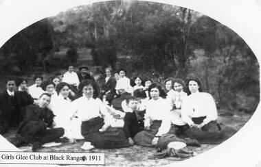
Photograph, Girls Glee Club in the Black Ranges 1911
... Girls Glee Club at Black Ranges 1911... grampians Photograph Girls Glee Club in the Black Ranges 1911 Girls ...Girls Glee Club at Black Ranges 1911stawell -
 Stawell Historical Society Inc
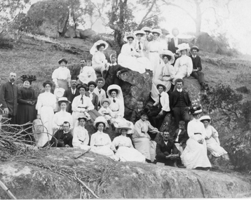
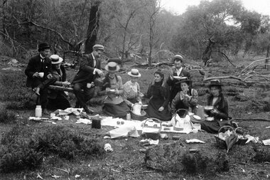
Photograph, Picnic in the Bush -- Various Families c1900
... Picnic in the bush. Probably Black Ranges. Church group.... home. Picnic in the bush. Probably Black Ranges. Church group ...Picnic in the bush. Probably Black Ranges. Church group.Black and White Photograph of a group of people in a bushland setting. Women wearing long dresses with large hats. Photograph cropped.Dear Mert, There's nothing like keeping up appearances so you see I got as near the Parson as possible. How do you do di de do how as you do de do di do etc. is Jimmy living where hes living now or has he gone away. From yours sinc. M the other side. P.S. don't run away with the idea that it was Jack I was edging up to. Forgot your number its late to go over home. stawell -
 Stawell Historical Society Inc
Photograph, Picnickers probably in the Black Ranges c1900
... Picnic Scenes c 1900 probably in the Black Ranges.... grampians Photograph Picnickers probably in the Black Ranges c1900 ...Picnic Scenes c 1900 probably in the Black Ranges.stawell -
 Stawell Historical Society Inc
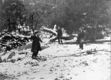
Photograph, Snow Scene in the Black Ranges 1901-- 2 Photos
... Two photographs of Snow Scene Black Ranges 1901... grampians Photograph Snow Scene in the Black Ranges 1901-- 2 Photos ...Two photographs of Snow Scene Black Ranges 1901stawell -
 Stawell Historical Society Inc
Photograph, Picnickers probably in the Black Ranges c1900
... Picnic Scenes c 1900 probably in the Black Ranges.... grampians Photograph Picnickers probably in the Black Ranges c1900 ...Picnic Scenes c 1900 probably in the Black Ranges.stawell -
 Stawell Historical Society Inc
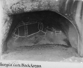
Photograph, Bunjil’s Cave Aboriginal Rock shelter in the Black Ranges Stawell
... Bunjil’s Cave Aborigional Rock shelter. Black Ranges... in the Black Ranges Stawell Bunjil’s Cave Aborigional Rock shelter ...Bunjil’s Cave Aborigional Rock shelter. Black Ranges Stawell.stawell aboriginal -
 Stawell Historical Society Inc
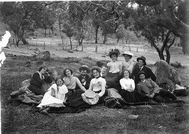
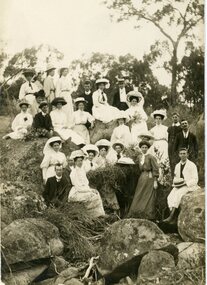
Photograph, Picnicers amongst the boulders c1910. Possibly Black Ranges
... Group at Picnic amongst boulders. C1910. Possibly Black... Black Ranges. On Reverse: Empire Loge with name Post Card Stamp ...Group at Picnic amongst boulders. C1910. Possibly Black Ranges.On Reverse: Empire Loge with name Post Card Stamp For Correspondence For Address Only {All In Green Print}stawell -
Stawell Historical Society Inc
Map, Plan of Division Line between Ararat and Stawell Shires 1877, 1877
... Grampians Halls Gap Black Range Stawell Shire Ararat Shire... 28.12.77 Grampians Halls Gap Black Range Stawell Shire Ararat Shire ...Grampians Halls Gap Black Range Stawell Shire Ararat Shire Crowlands TownshipVery Large Map Printed on Linen with Table of bearingsExamined by H.C. Malcolm 28.12.77 Traced By D.H. Meike 28.12.77survey -
 Stawell Historical Society Inc
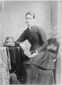
Photograph, Miss Mary Dow -- later Mrs. Oram & a member of the Stawell Corp of the Salvation Army in uniform
... of the Stawell Corp of the Salvation Army. Later lived in the Black... of the Stawell Corp of the Salvation Army. Later lived in the Black Range ...Studio Portrait - Miss Mary Dow (later Oram) a member of the Stawell Corp of the Salvation Army. Later lived in the Black Range.Lady in Salvation Army uniform in Studio Portrait, seated beside a table with bonnet on it and holding a book. stawell religion -
 Stawell Historical Society Inc
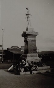
Photograph, Soldiers’ Memorial World War 1 in Main Street -- Different angle
... in the backgrounds, looking south with the black range on right side of photo.... in the backgrounds, looking south with the black range on right side of photo ...Side view of Soldiers’ Memorial World War 1 with wreaths at base and Chapman Bakery in background. Black & white photo of Soldiers Memorial World War 1. This photo is a side view of the memorial showing Chapman bakers shop in the backgrounds, looking south with the black range on right side of photo.stawell ww1 -
 Stawell Historical Society Inc
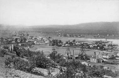
Photograph, Panorama of Stawell Township with Poppet heads & Government Dam later No 2 Reservoir at centre of photo1878 Herbert
... Reservoir at centre of photo with Black Ranges in background... of photo with Black Ranges in background. Stawell East State ...Stawell Town Poppet heads and Government Dam later No2 Reservoir at centre of photo with Black Ranges in background. Stawell East State School on left, Wimmera Battery on right of photo. 1878.Victorian Views. C. Herbert, Photo. Stawell. 1878stawell mining -
 Stawell Historical Society Inc
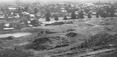
Photograph, Panorama of Stawell from Big Hill with the Stawell Water Supply Dam -- 3 Photos
... in foreground Black Range at Back. Stawell Court House with mining holes... Hill December 9th 1928 Davis Open Cut in foreground Black Range ...Three views from Big Hill December 9th 1928 Davis Open Cut in foreground Black Range at Back. Stawell Court House with mining holes in foreground. Water Reservoir between trees. 3 Black & White photos of Stawell water supply dam taken from Big Hill.(29.11). Stawell from Big Hill Dec 9th 1928. - (29.11a) Nov 1928. L.C. Langford. - (29.11b). Stawell from Big Hill Dec 9th 1928. stawell -
Stawell Historical Society Inc
Map, CFA, Map of Stawell / deep Lead Fire of 31/12/2005, 2006
... and Burned on New years Eve with nasty North Wind, Southerly to Black... with nasty North Wind, Southerly to Black range, Then Easterly ...Fire Started from lightning strike near Deep Lead and Burned on New years Eve with nasty North Wind, Southerly to Black range, Then Easterly towards Great western. Fire Subduded by Rain Event on 2/1/2006.Laminated Coloured Map of Stawell / Deep Lead 4/1/2006 with Fire Perimeters.CFA GIS Services Community Services -
 Stawell Historical Society Inc
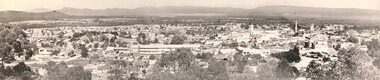
Photograph, Panorama of Stawell from Big Hill c 1966
... prominent in photo. Grampians and Black Range in background. Visible... technical school prominent in photo. Grampians and Black Range ...1966 Panorama from Big Hill. New technical school prominent in photo. Grampians and Black Range in background. Visible are St Patrick's Church, Kinsella, Nalders Garage, Town Hall, St Matthews, Upper Main Street. Trees in foreground.Panorama of Stawell from Big Hill in 1966Magnificent View of Stawell from Big Hill c 1966stawell, education, panorama, streetscape -
Stawell Historical Society Inc
Photograph, Aerial Photos of Stawell from a Hot Air Balloon 1992 -- 12 Photos
... , Moonie Dams 12. Darlington Road looking towards Black Range... Street looking West 9. Looking towards Black Range 10. Moonie ...Series of 12 Aerial Photos of Stawell. Hot Air Balloon 1992 1. Cnr Maude St & Grant Street 2. Maude St Napier Street & Railway cutting 3. Trotting Track 4. Roundabout Wimmera & Sloane Street 5. Florence Street towards Cato Lake & Park 6. Grampians Range with Lake Lonsdale near center 7. Gold Reef Mall looking West 8. Church Street looking West 9. Looking towards Black Range 10. Moonie Dams Darlington Road Leisure Complex 11. Stawell Gold Mine Evaporations Dams, Stawell Water Reservoirs, Moonie Dams 12. Darlington Road looking towards Black RangeColour photographs from Airstawell -
 Stawell Historical Society Inc
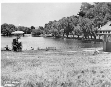
Photograph, Cato Lake looking towards the Stawell Swimming Clubrooms. c1930 - 1940
... Rooms. Black Range in the distance and Gazebo on the right.... Black Range in the distance and Gazebo on the right. There are 2 ...Looking across Cato Lake to Stawell Swimming Club Changing Rooms. Black Range in the distance and Gazebo on the right. There are 2 bench seats beside the lake and a person sitting in one on the right hand side. "Cato Park Stawell" is printed on the right lower corner. c 1930-1940Black & white photo of Cato Lake with change rooms in the distance. The view shows one side of the lake with trees along the edge and Gazebo on the right. Cato Park Stawellstawell -
 Stawell Historical Society Inc
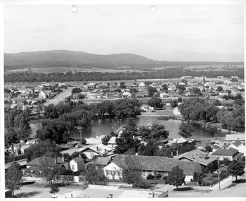
Photograph, Cato Lake from top of clock tower c 1965
... West. Black Range in background. Stawell West State School... tower c 1965 looking South West. Black Range in background ...Photo taken from top of clock tower c 1965 looking South West. Black Range in background. Stawell West State School is in the far top right just in front of a band of trees. The swimming pool is hidden by pine trees in the center of the lake and identified but a line of flag posts either side of the pool.Aerial black and white view of Cato lake. One photo is original and the other a copy. The photo was taken from the top of the clock tower looking South West. c 1965.stawell, streetscape -
 Stawell Historical Society Inc
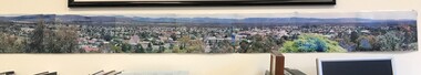
Photograph, Panorama of Stawell from Big Hill c 1998 -- Coloured
... . Black Range and Grampians visible in background. Panorama photo... Panorama of Stawell c 1998 Overlooking Stawell. Black Range ...Colour Panorama of Stawell c 1998 Overlooking Stawell. Black Range and Grampians visible in background. Panorama photo was taken by Irene Read for Barbara Bennet, a member of the "Big Hill Action Group" The group were fighting Stawell Gold Mines proposal to "Open Pit" the Big Hill area. SGM was at that time owned by an American Company - Pitston-Brinks. Laminated panorama of Stawell from Big Hill c 1998 -- Coloured photographs producing a panorama of Stawell. stawell, panorama -
 Queenscliffe Maritime Museum
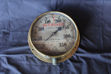
Pressure Gauge
... face and black numbers. range: 0-350 lbs/sq. inch... HMVS Lonsdale with white face and black numbers. range: 0-350 ...HMVS Lonsdale is significant as one of only three surviving second-class torpedo boats that were used in the defence of the Australian and New Zealand colonies. HMVS Lonsdale is historically significant as a rare representative of a Victorian second-class torpedo boat. Lonsdale demonstrates technical significance as an early example of the development of the fast attack torpedo craft.Round brass pressure gauge from HMVS Lonsdale with white face and black numbers. range: 0-350 lbs/sq. inchE.Boudon's Pantent Trade Mark: Delta Hannan & Buchcananhmvs, lonsdale, pressure gauge, torpeto boat -
 Greensborough Historical Society
Folder, Black Family Land Titles, 1891o
... in present-day Watsonia owned by members of the Black Family, ranging... in present-day Watsonia owned by members of the Black Family, ranging ...Collection of seven Certificates of Title for land in present-day Watsonia owned by members of the Black Family, ranging from 1891 to 1939, including transfers to 1967.Looseleaf folderblack family, watsonia -
 Stawell Historical Society Inc
Photograph, St. Patrick’s Catholic Church
... is of Black Ranges faced with Grampians Freestone. The bell tower.... The construction is of Black Ranges faced with Grampians Freestone ...St. Patrick’s Catholic Church and surrounding buildings 1880's. The church was opened in 1873. The construction is of Black Ranges faced with Grampians Freestone. The bell tower is 70 feet high, and the walls are 30 inches thick. The church was opened on 30th March 1873 by the Bishop of Melbourne, the Right Reverend Dr. Goold. The Historical Society have a programme for this opening - tickets for front seats were 10/- each. The sanctuary was added during 1927 as was a white marble altar which was the gift of a parishioner. Much earlier - In 1865 - a wooden Catholic Church was built on this street near the Court House site. The wooden building became too small for the congregation and this church was commenced before the end of 1869. Sepia photograph of St Patrick's Catholic Church and surrounding buildings. The photo also shows mining operations in Stawell with the Grampians in the background c 1880's. Two enlargements of the Catholic Church are taken from the sepia photograph and marked as 105a.C. Herbert. Photo. Copyright Registered Stawell. on the back is written "Stawell from Big Hill c 1880" stawell, panorama, mining -
 The Beechworth Burke Museum
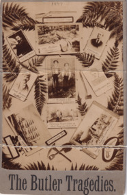
Photograph, Enterprise Photo Company, 1897
... / Butlers supposed Wife / Frisco / Examining Burgess corpse at Black... / Frisco / Examining Burgess corpse at Black Range near Parkes NSW ...The photograph depicts eleven vignettes relating to the murders of Captain Lee Weller, Charles Burgess and Arthur Preston by Frank Butler (born Richard Ashe, alias Frank Harwood). Some historians consider Butler to be Australia's first serial killer. Butler submitted written advertisements to the classified columns of the Sydney Morning Herald newspaper looking for people to join him in prospecting for gold. Butler took his victims into the Blue Mountains in New South Wales and told fabricated stories of gold mines worth thousands of pounds. He then made his victims dig their own graves under the guise that they were digging for gold. He would then shoot them, take their valuables, and bury them.Sepia rectangular photograph printed on matte photographic paper mounted on card.Obverse: 1897 / Butler's inseparable Friend / Cap ' Lee Weller / The Victim Burgess / A OT Preston / Frank Harwood / alias / Butler / J. Mulhall & Son / discoverers of Burgess grave / Butlers supposed Wife / Frisco / Examining Burgess corpse at Black Range near Parkes NSW / The Swanhda / His Prospecting Tools / Burgs Waggonette used for Prospecting sold Butler / (?) / The Butler Tragedies Reverse: BMMA03308 / Removal story of the / 1997.3119 / Butler murders near / Parkes NSW 1897 / 84 - 35 - 1 / Enterprise Photo Company, / 26 Elizabeth Street, / SYDNEY. /entertainment album, captain lee weller, charles burgess, arthur preston, frank harwood, frank butler, crime, blue mountains, new south wales, murder, tragedy, gold, gold mine, sydney morning herald, swanhilda, richard ashe -
 Footscray Community Arts Centre
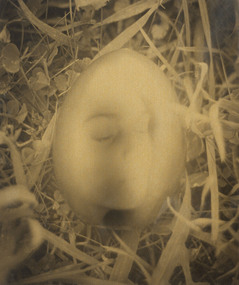
Golden Egg, Peta Clancy, (exact); 1992
... MEDIUM: Unknown DESCRIPTION: Image ranges from black/dark... DESCRIPTION: Image ranges from black/dark brown to gold/yellow Timber ...MEDIUM: Unknown DESCRIPTION: Image ranges from black/dark brown to gold/yellow Timber outer frame with glass front White board inner frame Inscription on reverse Signed and dated; bottom proper left corner on white boarsegg, clancy golden -
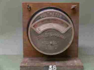 Federation University Historical Collection
Scientific Instument, Stanley D'Arsonval, Voltmeter
... D.C. Voltmeter 180-270 volt range. Black cylindrical shape... Scientific Instument Voltmeter D.C. Voltmeter 180-270 volt range ...D.C. Voltmeter 180-270 volt range. Black cylindrical shape, with partly chrome plated front cover and simi-circular glass window. Pointer indicator, semi-circular scale. This panel mount instrument is attached to a crudely varnished wooded stand for bench-top use. Serial Number 2172Vscientific instrument, ballarat school of mines, voltmeter -
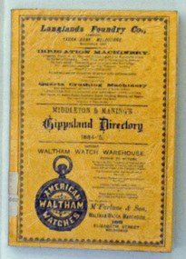 Orbost & District Historical Society
book, E-Gee Printers, Middleton & Manning's Gippsland Directory 1884-5, 1983
... . On the front cover in black print is a range of advertisements or local.... On the front cover in black print is a range of advertisements or local ...The 1884-1885 Directory was the first year of publication for the Middleton and Manning's Gippsland Directory. It was first published by Ale Middleton and Francis Beresford Manning. Beginning with advertisements from local businesses of the time, this is followed by a short gazetteer of places around the region, as well as general information on the districts of Gippsland. The main part of the Directory consisting of about 100 pages, is the Alphabetical Directory. Listed alphabetically by surname under each region, this lists heads of household (mostly male but there are a few females mentioned), together with their occupation and address.The list includes farmers, labourers, coach painters, dairywoman, teacher, saddler, brickmaker, merchant, laundress, hotel keeper, minister of religion, dressmaker, grocer, grazier, gasfitter, seedsman, coachbuilder, engineer, auctioneer, upholsterer, fowler, journalist, surveyor, musician, traveller, watchmaker, solicitor, restaurant keeper, blacksmith and miner. It is not just "business owners" mentioned in this directory it is everyone. (ref Gen E Books)This is a useful reference tool.A 135 pp soft covered book with an orange/brown cover. On the front cover in black print is a range of advertisements or local businesses. It contains a short gazetteer of places in the region as well as general information on the districts of Gippsland. The main part of the directory is an alphabetical list of the household , with occupations and addresses. This is a reprint of the original.directory-gippsland book-middleton-manning-1884-5