Showing 7 items matching "bluestone culvert"
-
 Ballarat Heritage Services
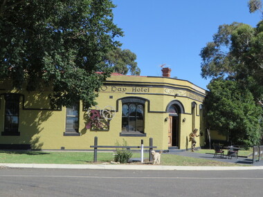
Photograph - Photograph - Colour, Break O'Day Hotel, Corindhap, 2016, 29/01/2017
... ...bluestone culvert...Ballarat Heritage Services PO Box 2209 Bakery Hill Post Office goldfields corindhap break o'day break o'day hotel hotels bluestone culvert Painted brick hotel and Corindhap Break O'Day Hotel, Corindhap, 2016 Photograph Photograph - Colour Australia Victoria Corindhap Clare Gervasoni ...Painted brick hotel and Corindhapcorindhap, break o'day, break o'day hotel, hotels, bluestone culvert -
 Sunshine and District Historical Society Incorporated
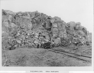
Photograph - Albion Quarry Photographs
... The quarry extracted high quality bluestone, ideal for road construction, railway ballast, culverts, bridges and public buildings and private homes. ...The quarry extracted high quality bluestone, ideal for road construction, railway ballast, culverts, bridges and public buildings and private homes. ...Albion Quarry began operations in 1888, and became one of the largest bluestone quarries in Australia, later it became the Sunshine municipal tip. In 1888, quarrying first began on the site by the Wales family. The quarry extracted high quality bluestone, ideal for road construction, railway ballast, culverts, bridges and public buildings and private homes. The site quickly became one of the most productive basalt quarries in the region. In 1907, the Albion Quarry Company was formed as a partnership between Alexander Wales, James Watter, Peter Rumpf, Thomas Adams, William Wright Wales and Alexander George Wales (later Sir George Wales, Lord Mayor of Melbourne) The company became the largest producer of quarry products in the Commonwealth. The quarry pit was, at one time, the largest in Australia. In January 1965, Boral acquired both Albion Quarry and Reid Quarry, merging them into Albion Reid Pty Ltd. Quarrying there continued until the late 1960s–early 1970s. After quarrying ceased, the enormous pit was used as the Sunshine municipal tip. Dumped into the hole included household waste, industrial waste, chemical waste, radioactive waste and large quantities of unknown fill. Dumping continued until 1990. In the 1990’s, a methane powered electricity plant was installed on the site, but it failed due to insufficient methane production. In 2019, the former quarry made national news due to ground contamination affecting 69 residential homes, 6 commercial properties and a community park. The site is now being reserved for the future Sunshine Energy Park and is awaiting redevelopment. This quarry is historically significant for its scale, its role in Melbourne’s infrastructure, and its later environmental legacy.These photographs document the initial phase of quarrying, featuring manual labour and transportation by horse and cart.Albion basalt quarryalbion quarry, ballarat road, albion, basalt, hulett street -
 Marysville & District Historical Society
Booklet (Item) - Information booklet, Artworkz Tourism, The Big Culvert, Unknown
... The Big Culvert is a historic granite and bluestone arch along the Yarra Track, a major route to Melbourne through the 1800s. ...An information booklet that was produced as a guide to The Big Culvert.An information booklet that was produced as a guide to The Big Culvert. The Big Culvert is a historic granite and bluestone arch along the Yarra Track, a major route to Melbourne through the 1800s. Built in 1870 and a major piece of infrastructure for its time, the heritage listed culvert allowed water to flow under often-flooded the road. The Yarra Track is the former name of the gold fields road from Healesville to the Woods Point and Jordan Goldfields, in Victoria, Australia. A direct route via the Yarra River and the Great Divide was discovered by Rieck in September 1862 and became known as the Yarra Track. Early in 1863, the Victorian Government decided to construct a 193-kilometre (120 mile) road along the route. Its original width varied between 4 and 6 metres (12 and 20 feet), and was designed to accommodate horse-drawn vehicles. The Track involved the climbing of the Black Spur, descent into the Acheron Valley, and then through Marysville to the Cumberland where it followed the existing route.the big culvert, yarra track, victoria, healesville, wood's point goldfields, jordan goldfields, black spur, acheron valley, cumberland valley -
Marysville & District Historical Society
Flyer (Item) - Information flyer, Artworkz Tourism, The Big Culvert, 26-03-2016
... The Big Culvert is a historic granite and bluestone arch along the Yarra Track, a major route to Melbourne through the 1800s. ...An information flyer that was produced as a guide to The Big Culvert.An information flyer that was produced as a guide to The Big Culvert. The Big Culvert is a historic granite and bluestone arch along the Yarra Track, a major route to Melbourne through the 1800s. Built in 1870 and a major piece of infrastructure for its time, the heritage listed culvert allowed water to flow under often-flooded the road. The Yarra Track is the former name of the gold fields road from Healesville to the Woods Point and Jordan Goldfields, in Victoria, Australia. A direct route via the Yarra River and the Great Divide was discovered by Rieck in September 1862 and became known as the Yarra Track. Early in 1863, the Victorian Government decided to construct a 193-kilometre (120 mile) road along the route. Its original width varied between 4 and 6 metres (12 and 20 feet), and was designed to accommodate horse-drawn vehicles. The Track involved the climbing of the Black Spur, descent into the Acheron Valley, and then through Marysville to the Cumberland where it followed the existing route.the big culvert, yarra track, victoria, healesville, wood's point goldfields, jordan goldfields, black spur, acheron valley, cumberland valley -
 Marysville & District Historical Society
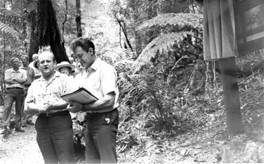
Photograph (Item) - Black and white photograph, Unknown
... The Big Culvert is a historic granite and bluestone arch along the Yarra Track, a major route to Melbourne through the 1800s. ...A black and white photograph taken at the unveiling of the sign placed at The Big Culvert.A black and white photograph taken at the unveiling of the sign placed at The Big Culvert. The Big Culvert is a historic granite and bluestone arch along the Yarra Track, a major route to Melbourne through the 1800s. Built in 1870 and a major piece of infrastructure for its time, the heritage listed culvert allowed water to flow under often-flooded the road. The Yarra Track is the former name of the gold fields road from Healesville to the Woods Point and Jordan Goldfields, in Victoria, Australia. A direct route via the Yarra River and the Great Divide was discovered by Rieck in September 1862 and became known as the Yarra Track. Early in 1863, the Victorian Government decided to construct a 193-kilometre (120 mile) road along the route. Its original width varied between 4 and 6 metres (12 and 20 feet), and was designed to accommodate horse-drawn vehicles. The Track involved the climbing of the Black Spur, descent into the Acheron Valley, and then through Marysville to the Cumberland where it followed the existing route.Unveiling of sign/ at "Big Culvert" In front Max Cockerrell and - Rear: second back Geoff Pope R.H.S. rear: Nancy "/ Anne "the big culvert, yarra track, victoria, healesville, wood's point goldfields, jordan goldfields, black spur, acheron valley, cumberland valley -
 Marysville & District Historical Society
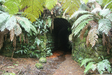
Photograph (Item) - Colour photograph, 20-09-2008
... The Big Culvert is a historic granite and bluestone arch along the Yarra Track, a major route to Melbourne through the 1800s. ...A colour photograph of the entrance to The Big Culvert.A colour photograph of the entrance to The Big Culvert. The Big Culvert is a historic granite and bluestone arch along the Yarra Track, a major route to Melbourne through the 1800s. Built in 1870 and a major piece of infrastructure for its time, the heritage listed culvert allowed water to flow under often-flooded the road. The Yarra Track is the former name of the gold fields road from Healesville to the Woods Point and Jordan Goldfields, in Victoria, Australia. A direct route via the Yarra River and the Great Divide was discovered by Rieck in September 1862 and became known as the Yarra Track. Early in 1863, the Victorian Government decided to construct a 193-kilometre (120 mile) road along the route. Its original width varied between 4 and 6 metres (12 and 20 feet), and was designed to accommodate horse-drawn vehicles. The Track involved the climbing of the Black Spur, descent into the Acheron Valley, and then through Marysville to the Cumberland where it followed the existing route.the big culvert, yarra track, victoria, healesville, wood's point goldfields, jordan goldfields, black spur, acheron valley, cumberland valley -
![Wal Ives & Bert [Watson] at the outlet of the Kew Main Drain](/media/collectors/550653872162f11fb04854aa/items/61593ef27608a87f688412b1/item-media/61594a5a7608a87f68848c29/item-fit-380x285.jpg?cb=6) Kew Historical Society Inc
Kew Historical Society IncPhotograph - Wal Ives & Bert [Watson] at the outlet of the Kew Main Drain, c.1900
... culvert and embankment over Connor's Creek, on Belford-road. This may be the embankment on which the boys are sitting. connors creek -- kew (vic) wal ives albert watson belford road yarra river -- kew (vic.) creeks -- kew (vic.) drains -- kew (vic.) In ink on photo: "Wal & Bert" Original, small photographic positive on card of two boys, identified by the donor as 'Wal Ives and Bert' [Albert Watson] sitting on bluestone capping above an outlet of Connor's Creek. ...Connor's Creek is/was one of two major waterways bisecting Kew, both of which empty into the Yarra River. Connor's Creek originates near the grounds of Genazzano FCJ College, which is one of the highest points in Kew. Until the 1930s, this was an open creek until a barrel drain - the Kew Main Drain - was constructed. As the creek ran through Kew it cut across a number of roads the maintenance of which was a continuing concern for Kew Councillors. In August 1864, the Council called for tenders to erect a stone culvert and embankment over Connor's Creek, on Belford-road. This may be the embankment on which the boys are sitting.Original, small photographic positive on card of two boys, identified by the donor as 'Wal Ives and Bert' [Albert Watson] sitting on bluestone capping above an outlet of Connor's Creek. To the left of the boys is a barrel drain which at that stage was the outlet for Connor's Creek near the Yarra River. The retaining wall is constructed of brick. In ink on photo: "Wal & Bert"connors creek -- kew (vic), wal ives, albert watson, belford road, yarra river -- kew (vic.), creeks -- kew (vic.), drains -- kew (vic.)