Showing 20 items matching "boathouses - river yarra"
-
 Kew Historical Society Inc
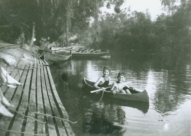
Photograph - Canoeing at Macauley's Boathouse, 1950s
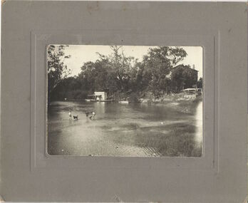
... Boathouses -- river yarra...Two children pictured in a canoe at Macauley's Boathouse on the River Yarra at Studley Park....Two children pictured in a canoe at Macauley's Boathouse on the River Yarra at Studley Park. Photograph Canoeing at Macauley's Boathouse ...Macauley's boat sheds (aka Kew Boatsheds) was located on the river at the western end of Molesworth Street, Kew.Black and white enlargement. Two children pictured in a canoe at Macauley's Boathouse on the River Yarra at Studley Park.Reverse: "Macauley's Boatsheds / M Holmes"boathouses -- river yarra, boathouses -- kew, macauley's boat shed, recreation -- canoeing -
 Kew Historical Society Inc
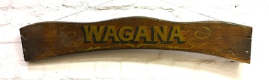
Sign, Wagana, 1920s
... ...boathouses - river yarra...Their entire fleet of rowing boats has now been replaced by fiberglass boats. burns' boatshed thames pulling boats yarra river -- kew (vic.) boathouses - river yarra "Wagana" Varnished wooden backplate of a rowing boat. ...In the 1920s and 30s, rowing on the Yarra was a very popular weekend pastime. Each of the early boats was individually named in gold letters on its varnished wooden backboard. This is all that remains of one of the Thames pulling boats from Burns' Boatshed at Studley Park which was destroyed by a falling tree in a storm. Their entire fleet of rowing boats has now been replaced by fiberglass boats.Varnished wooden backplate of a rowing boat. The shaped sign is embossed with the name 'Wagana" in gold lettering, outlined and shaded in black paint. Gilt scroll work surrounds the name. The ends of the backplate shows the holes where the plate was once attached to the seat of the boat. The name Wagana means 'to dance' in Wiradjuri language."Wagana"burns' boatshed, thames pulling boats, yarra river -- kew (vic.), boathouses - river yarra -
 Ballarat Heritage Services
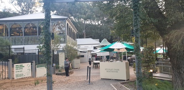
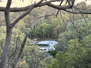
Photograph - Boathouse, Clare Gervasoni, Studley Park Boat House, 2025, 05/05/2025
... Boathouse...Yarra River...In 2025 it was one of two surviving boathouses on the Yarra River. Established by the Burns family, who were boat builders in nearby Punt Road, when boating became popular on the Yarra river. ...Photograph of the Studley Park Boathouse on the Yarra River at Kew. ...Studley Park Boathouse Yarra River boulevard Burn's BOathouse Studley Park Photograph of the Studley Park Boathouse on the Yarra River at Kew. ...Studley Park Boathouse was established in the 1860s. In 2025 it was one of two surviving boathouses on the Yarra River. Established by the Burns family, who were boat builders in nearby Punt Road, when boating became popular on the Yarra river. They offered a small boat hire, allowing visitors to hire rowing boats for the day. In the late 1990s refreshment rooms were added, as well as a a separate family residence. The Edwardian style building with arched verandah was added in the early 1910s. The Burns family were associated with the Boathouse for over 50 years, and Studley Park Boathouse is the oldest operating boathouse on the Yarra River. Studley Park was reserved as a public park in 1877. Day trippers and locals visited the park since the 1850s, and it was very popular for picnics.Photograph of the Studley Park Boathouse on the Yarra River at Kew. studley park boathouse, yarra river, boulevard, burn's boathouse, studley park -
 Ballarat Heritage Services
Photograph - Boathouse, Studley Park Boat House
... Boathouse...Yarra River...In 2025 it was one of two surviving boathouses on the Yarra River. Established by the Burns family, who were boat builders in nearby Punt Road, when boating became popular on the Yarra river. ...Photographs of the Studley Park Boathouse on the Yarra river at Kew. ...Studley Park Boathouse Yarra River boulevard Burns Burn's BOathouse Studley Park Photographs of the Studley Park Boathouse on the Yarra river at Kew. ...Studley Park Boathouse was established in the 1860s. In 2025 it was one of two surviving boathouses on the Yarra River. Established by the Burns family, who were boat builders in nearby Punt Road, when boating became popular on the Yarra river. They offered a small boat hire, allowing visitors to hire rowing boats for the day. In the late 1990s refreshment rooms were added, as well as a a separate family residence. The Edwardian style building with arched verandah was added in the early 1910s. The Burns family were associated with the Boathouse for over 50 years, and Studley Park Boathouse is the oldest operating boathouse on the Yarra River. Studley Park was reserved as a public park in 1877. Day trippers and locals visited the park since the 1850s, and it was very popular for picnics.Photographs of the Studley Park Boathouse on the Yarra river at Kew. studley park boathouse, yarra river, boulevard, burns, burn's boathouse, studley park -
 Eltham District Historical Society Inc
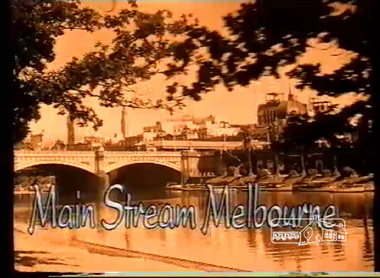
Film - Video (VHS), Screen Sound Australia, Main Stream Melbourne - The River Yarra on film and The Prize by Tim Burstall, 2004
... Main Stream Melbourne - The River Yarra on film (Screen Sound Australia, 2004) and The Prize (Eltham Films, Tim Burstall ,1960) Combining footage from more than 90 early newsreels, documentaries and short films which additionally features almost 200 photographs and illustrations - shows locals fishing and swimming in the river, holding canoe races and lazing at boathouses. ...Eltham District Historical Society Inc 728 Main Rd Eltham melbourne Main Stream Melbourne - The River Yarra on film (Screen Sound Australia, 2004) and The Prize (Eltham Films, Tim Burstall ,1960) Combining footage from more than 90 early newsreels, documentaries and short films which additionally features almost 200 photographs and illustrations - shows locals fishing and swimming in the river, holding canoe races and lazing at boathouses. ...Main Stream Melbourne - The River Yarra on film (Screen Sound Australia, 2004) and The Prize (Eltham Films, Tim Burstall ,1960) Combining footage from more than 90 early newsreels, documentaries and short films which additionally features almost 200 photographs and illustrations - shows locals fishing and swimming in the river, holding canoe races and lazing at boathouses. Also included is Tim Burstall's 1960 short film, The Prize, which tells the story of a boy, played by his then six-year-old son Tom, and his adventures with a kid goat. The film, shot on the Yarra, won a bronze award at the 1960 Venice Film Festival. Of specific interest, scenes from Warrandyte, Montsalvat footage from 1965, Heidelberg School Artists' Trail, Koornung School (1947) in North Warrandyte, Tim Burstall and The Prize (1960) with scenes on Brougham Street Bridge, and Yarra River scenes at Morrison's Breakwater at Eltham and the Bend of Isles at Kangaroo Ground.VHS Video cassette, 130 minutes. Converted to MP4 file format 02:16:11, 1.54GBthe prize (film), tim burstall, yarra river, warrandyte, brougham street bridge, montsalvat, bend of islands, heidelberg school artists trail, koornong school, morrisons breakwater, video recording -
 City of Melbourne Libraries
Photograph, Bull, Hugh Jones, 1897-1993, Princes Bridge Centenary pylons under construction
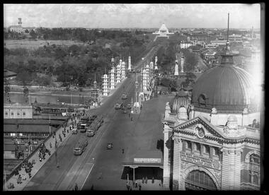
... boathouse visible across the Yarra is another glimpse into Melbourne’s past. “Boathouse Row” comprises 7 amateur rowing clubs, the first established in 1859 (Melbourne University Boat Club). Other Clubs were Richmond, Melbourne, Banks, Melbourne Grammar School, Yarra Yarra and Mercantile. South of the river...boathouse visible across the Yarra is another glimpse into Melbourne’s past. “Boathouse Row” comprises 7 amateur rowing clubs, the first established in 1859 (Melbourne University Boat Club). Other Clubs were Richmond, Melbourne, Banks, Melbourne Grammar School, Yarra Yarra and Mercantile. South of the river ...Princes Bridge Centenary pylons under construction Possibly taken from Young and Jacksons Hotel (formerly Princes Bridge Hotel) on the corner of Flinders and Swanston streets, Flinders Street Station’s clocks and main entrance dominate, along with its distinctive copper dome and decorative façade. The time on the main clock is 1.40pm, and the sign underneath, reflecting Melbourne’s upcoming Centenary reads, “We must accommodate our Centenary visitors! Citizens! Do your share by taking paying guests.” At left is the original Princes Bridge Station, today the site of Federation Square. The riverside tram terminus advertises a Café/Tobacconist/Refreshment Room selling cigars & cigarettes, fountain drinks & confectionery, and in smaller text: “Leave your boot repairs here”. Nearly everyone is dressed in dark suits, coats and hats. The footpaths are wide and there are no traffic lights. The roadway stretches towards the Shrine of Remembrance, not yet dedicated but very dominant on the skyline. Government House is clearly visible across the wide parkland that would come to be known as Kings Domain and that is an area of deep importance to the people of the Eastern Kulin. Originally, Birrarung was part of a network of swamps and lagoons linked to the course of the river. From 1896, Public Works Department engineer Carlo Catani, oversaw a new channel to straighten the river and the swamps and lagoons were filled with spoil from the channel works. From the same vantage point today, only the top of the tower of Government House would be visible. The photo captures the pylons along Princes Bridge, mid-construction and being installed to mark Melbourne’s Centenary. The pylons were not without controversy. Both The Argus and The Age bemoaned them for being “made almost entirely of imported softwood timber”, denying work to native hardwood timber workers and sawmillers, and leading visitors to think Australia did not have its own exceptional native hardwoods. The pylons were also variously described in their incomplete state, as unimaginative and resembling an oilfield. Published: The Age 5 September 1934 Featured in "Newsworthy: Melbourne in photographs 1933-1936" exhibition at East Melbourne Library, October to December 2023. Exhibition caption by project volunteer, Louise McKenzie Photographer notations on slide: "Pylons + St Kilda Rd C57" Published: Age (Melbourne, Vic. : 1854 - 1954), Wednesday 5 September 1934, page 11 Published title: DECORATIONS -- THEN AND NOW. Published caption: "Although not completed yet, some impression of the effect of the decorations on Princes-bridge may be obtained from the first picture which shows the majestic sweep of St Kilda road with the Shrine of Remembrance and Government House dominating the horizon. The area to the left of St. Kilda-road and in front of Government House is portion of the area which it is proposed to call the King's Domain, which extends to Domain-road and Anderson-street..." Description: East-facing, elevated view of Flinders Street Station and Princes Bridge, featuring partially completed pylons erected for Melbourne's Centenary celebrations. The Shrine of Remembrance and Government House can be seen in the distance. In the foreground are trams, cars and trucks, pedestrians, Batman Avenue tram terminus and refreshment rooms. Signage on Flinders Street Station encourages citizens to accommodate Centenary visitors. The Melbourne Centenary was held 1934-35 in celebration John Batman's proclamation that Melbourne "the place for a village". Centenary events included a visit by Prince Henry, Duke of Gloucester. A Centenary Cake measuring 50 feet in height and ten tons in weight was cut into 250,000 pieces and sold at 1 shilling per piece for charity. Spectacular floodlighting of city landmarks, the creation of the Pioneer Women's Memorial Garden, and the MacRobertson Air Race from London, were other notable activities. Research by project volunteer, Louise McKenzie: The photo in The Age collage of 5 September 1934 has a slightly cropped foreground. The original photo has been taken from an elevated vantage point, most probably the roof of the Nicholas Building on the corner of Flinders and Swanston streets. The right foreground is dominated by the main “clocks” entrance to Flinders Street Station, showing its distinctive copper dome and decorative façade. The time on the main clock is 1.40 pm. The main sign on the front of the Station reads, "We Must Accommodate our Centenary Visitors! Citizens! Do your share by taking paying guests. Write to The Official Centenary Accommodation Bureau, 436 Collins St. City. Tel M 4671”. Another sign at eye level at the main entrance says: “Cheap Trips on Sundays”. The sign on the end of the roof along the eastern side of the station reads, “The Babies Need Your Help! Support Broadmeadows Foundling Hospital Appeal. July and August”. Run by the Sisters of St Joseph of the Sacred Heart, St Joseph’s Foundling Hospital was a purpose built infants’ home for up to 300 babies, plus accommodation for expectant mothers, mainly single women. In the early 1930s, the department (Victorian Children’s Welfare Department) contracted St Joseph’s Foundling Hospital to care for an additional 60 infant state wards, and up to 175 non wards at any given time. In 1931 it also operated a mothercraft training school. The centre foreground shows the commencement of Princes Bridge. Beneath the left side of the bridge was the site of the original Princes Bridge Station, by this time incorporated into Flinders Street Station, and today the area is the site of Federation Square. It was linked to Flinders Street station by the railway tracks that ran underneath the northern approach to the bridge. This photo shows a tram terminus which has a Café/Tobacconist/Refreshment Room, selling cigars & cigarettes, fountain drinks & confectionary, and a sign: Leave your boot repairs here. In the foreground is a wide roadway running south/north, comprising two vehicle lanes each heading north/south, and a central section containing two sets of tram tracks. There are cars, buses and delivery vans on the roadway. The trams visible are Glen Iris (Route No. 6; tram no. 448), Toorak (Route No. 8, tram no. 333), ? (No. 7), ? (No. 1), and ? (No. 2A). The footpaths are extremely wide. There is a square newspaper/magazine stand on the eastern side footpath. And also a “Ferry” sign. There are no traffic lights, but a policeman is visible on the roadway. There are pedestrians – men, women, children, a porter with trolley, women with prams. Clothing comprises dark suits, coats and hats for nearly everyone. There are double headed “Collins Street” lights along the side of the roadway, and along the northern riverbank. The roadway in the foreground is an extension of Swanston Street, which becomes Princes Bridge, then St Kilda Road, stretching towards the Shrine of Remembrance, and diverting past it. The Shrine had not yet been officially dedicated, and looks very white and dominant on the skyline. On the LHS of St Kilda Road, Government House is clearly visible across the wide parkland to be known as Kings Domain. The Kings Domain area is important to the people of the Eastern Kulin nation, and also has historical importance for its association with the early settlement of Melbourne and the foundation of British colonial administration in Victoria. On the southern side of the Yarra River (Birrarung) an historic rowing boathouse is visible, located adjacent to the Alexandra Gardens. Originally Birrarung was part of a network of swamps and lagoons linked to the course of the river. From 1896, under the guidance of engineer Carlo Catani* a new channel to straighten the river was created and the swamps and lagoons were filled with spoil from the channel works. The gardens were then created and completed in time for a Royal visit by the Duke of York in May 1901. The gardens are named after Alexandra of Denmark, the wife of King Edward VII. Both these areas, plus the Royal Botanic Gardens Victoria, Shrine of Remembrance Reserve, Sidney Myer Music Bowl, Government House, and the Queen Victoria Gardens together form the Domain Parklands. The extent of the subsequent plantings is evident today, where from the same vantage point only the top of the tower of Government House would be visible. *Catani was born in Florence in 1852, but after arriving in Melbourne worked as a civil engineer for the Victorian Government. His last major project was the reclamation of the foreshore of St Kilda, envisaged in the style of a European resort, complete with a split level esplanade, bathing pavilions, dance halls, amusements and a French-Italian style of landscape complete with palms. The gardens at the end of Fitzroy Street, St Kilda, now bear his name. The historic boathouse visible across the Yarra is another glimpse into Melbourne’s past. “Boathouse Row” comprises 7 amateur rowing clubs, the first established in 1859 (Melbourne University Boat Club). Other Clubs were Richmond, Melbourne, Banks, Melbourne Grammar School, Yarra Yarra and Mercantile. South of the river and west of the bridge is an area today developed into the Melbourne arts precinct of Hamer Hall and the Arts Centre. But at this time it was the home of Wirths Olympia Circus, which comprised Wirths Pleasure Park (an amusement park), a 5,000 seat auditorium – Hippodrome, a roller skating rink, a glaciarium, a cinema, and the Green Mill Dance Hall. Dog shows were also held at Olympia. The Green Mill Dance Hall closed in 1950, and the remainder of the Wirth buildings on site were destroyed by fire in December 1953. The feature of the photo is the pylons erected along Princes Bridge to mark Melbourne’s Centenary in 1934. The sixteen plastered pylons were designed by Roy Prentice, the second person to qualify as an architect at The University of Melbourne’s Bachelor of Architecture degree, in 1933, aged 27. Simon Reeves in his article marking the 100th birthday of Roy Prentice on 20 June 2006 reports that the State Electricity Commission sponsored this work, and the Argus reported that “… the pylons were “illuminated from within to give the effect of soft radiance”. Australia Home Beautiful 1 Oct 1934 reports in a very detailed and comprehensive article: The 10 taller pylons, including flagpole, were 48 ft, with a base of 8 ft. Timber-framed and faced with fibrous plaster and galvanised sheet iron, each structure was securely bolted to a concrete foundation three feet in depth. Panels of glass let into the shaft of each pylon were indirectly lit by 40, 100 watt lamps, and the upper bank of internal lamps were dyed so as to flood the panels with a deep red light. The decorative painted shields and flagpoles/pennants were illuminated by three 200 watt projectors concealed in the roof of each pylon, and were part of an electric night light decoration scheme involving 28 miles of wire to supply more than 20,000 lights. An article in the Argus on 18 October 1934 provided minute detail of the lighting erected in Melbourne for the Centenary, converting it “… into a coloured fairyland by night.” The estimated cost of 10 pounds per hour the lights were on. The display included 800 standard light poles 30 feet high which were tiered with electric bulbs concealed in inverted cones, 138 specially designed “Venetian poles” draped in flags trophies and streamers. The streets included in the electric night light decoration scheme were Bourke Street from Spring to William, the entire length of Collins Street, Flinders Street from Elizabeth to Spring, Lonsdale Street from Elizabeth to Swanston, Swanston and Elizabeth Streets from Flinders to Lonsdale, and parts of Springs and Spencer Streets. Together with the Princes Bridge pylons, approximately 28 miles of wire was required to supply power to the more than 20,000 lights. And that is just in the city of Melbourne. It was estimated the same amount of lighting was duplicated among other local councils. The pylons were not without controversy. The Argus on 28 August 1934 in an article headed “Imported Timber in Pylons” reported that the Princes Bridge pylons are “made almost entirely of imported softwood timber”, and have therefore denied work to native hardwood timber workers and sawmillers. The same day the Melbourne Age ran a similar story, bemoaning the fact that foreign oregon had been used which may lead tourists to think Australia did not have its own exceptional native hardwoods. A Camberwell City Councillor described the pylons as unimaginative, and the Herald reported that skeletons of pylons for the Centenary decorations in their present form led the area to resemble an oilfield! The Yarra River and Princes Bridge have long been a focal point of Melbourne life. In the early days of European settlement in Melbourne a rope-hauled punt carried people across the Yarra River. A surge in population and increased shipping traffic created a need for a bridge. There was difficulty in agreeing on a suitable site for the bridge (options were crossing at Elizabeth, Swanston, Queen or Market Streets), but the NSW Government favoured Swanston Street and the Melbourne Town Council decided on a temporary bridge across the Yarra spanning from the foot of Swanston Street. This first bridge was a single span timber toll bridge designed by Scottish born bridge designer David Lennox, and completed in 1845. It was 120 feet long, had a roadway of 17 feet wide, and a footpath on one side of 4 feet. It was leased to the Melbourne Bridge Company in the name of Robert A Balbirnie. The tollhouse was on the north side of the river and the toll keeper, Patrick Doherty, was credited with saving nine lives during the four years he was in charge of the toll station. The second bridge was stone (completed 1850), and named Prince’s Bridge after the HRH Prince of Wales, later Edward VII. It was designed with an elliptical single arc and an exceedingly small rise in proportion to the span. However, this design created an obstacle for flood waters, and together with Melbourne’s increasing population it was quickly apparent that a new bridge was required. At its opening on 15 November 1850 coincided with the imminent declaration of Victoria as a separate colony, it provided a moment of great celebration for Melbournians and “The opening ceremony was described as the grandest processional display witnessed in the colony.” (ToMelbourne.com.au) Princes Bridge in its present form, as depicted in this photograph, was designed by Jenkins, D’Ebro and Grainger, and constructed in 1886-88 by David Munro. John Grainger (father of Australian composer Percy Grainger) did the majority of the design work for the bridge. The structure was to have three arches each 96 feet wide measured across the river, and the banks on both sides were raised to allow more space for floodwater to flow. St Kilda Road was originally many feet below the current level. The bridge is of architectural significance for its substantial size, giant half columns, extensive use of wrought and cast iron, decorative elements (cast-iron lamps) and the skilled stonemasonry in the construction of the abutments and piers. Its main design features are similar to those of Blackfriars Bridge in London (1870). The bluestones were quarried from Footscray, the Malmsbury stones were from quarries at Kyneton, and the granite from Harcourt. The cost was met by the State of Victoria, City of Melbourne, and six out of seven of its municipalities, and their coats of arms feature on the bridge. The building of the bridge reflected the boom period of Melbourne, including the Victorian gold rush 1851- late 1860s, and its contractor, David Munro, was also responsible for the construction of Queens Bridge and Sandridge Railway Bridge. The Centenary pylons are no longer in place, but today this intersection still plays a major part in Melbourne’s daily life: people still meet “under the clocks” at Flinders Street station, and the route in and out of the city along St Kilda Road is often a feature of parades such as Moomba, the Grand Final Parade, and of course the Anzac Day Parade which commences at the Princes Bridge intersection and finishes at the Shrine of Remembrance. There are many tram routes, which cross the Bridge, and it directs pedestrians towards the Arts Precinct, the various components of Domain Park, plus the Southbank restaurant and rowing precincts. Even though this is a street scene, it feels very intimate; the viewer is instantly immersed in the activity of a Melbourne afternoon, looking down St Kilda Road from a viewpoint near today’s Federation Square. References: DECORATIONS -- THEN AND NOW. (1934, September 5). The Age (Melbourne, Vic. : 1854 - 1954), p. 11. Retrieved September 21, 2023, from http://nla.gov.au/nla.news-article205880269 'Flinders Street railway station', Wikipedia, https://en.wikipedia.org/wiki/Flinders_Street_railway_station 'St Joseph’s Foundling Hospital (1901-75)', Finding Records, Department of Health and Human Services, State of Victoria, https://www.findingrecords.dhhs.vic.gov.au/collectionresultspage/St-JosephsFoundling-Hospital-Babies-Home#departmental-administration 'Alexandra Gardens', City of Melbourne, https://www.melbourne.vic.gov.au/community/parks-open-spaces/major-parks-gardens/Pages/alexandra-gardens.aspx 'Wirths Circus', Wikipedia, https://en.wikipedia.org/wiki/Wirth's_Circus 'Roy Prentice: Centenary Architect', Built Heritage Pty Ltd, Simon Reeves, https://www.builtheritage.com.au/downloads/prentice.pdf 'Princes Bridge', Heritage Council Victoria, https://vhd.heritagecouncil.vic.gov.au/places/817 PORT PHILLIP. (1846, April 1). The Sydney Morning Herald (NSW : 1842 - 1954), p. 3. Retrieved September 21, 2023, from http://nla.gov.au/nla.news-article12886251 'Edward VII', Wikipedia, https://en.wikipedia.org/wiki/Edward_VII 'Princes Bridge', ToMelbourne.com, https://tomelbourne.com.au/princes-bridge/ 'Princes Bridge', eMelbourne, https://www.emelbourne.net.au/biogs/EM01189b.htm 'Princes Bridge', Australia for everyone, http://australiaforeveryone.com.au/files/melbourne/princes-bridge.html 'Victorian gold rush', Wikipedia, https://en.wikipedia.org/wiki/Victorian_gold_rush IMPORTED TIMBER IN PYLONS (1934, August 28). The Argus (Melbourne, Vic. : 1848 - 1957), p. 9. Retrieved September 21, 2023, from http://nla.gov.au/nla.news-article10952507 Princes-Bridge Pylons. (1934, August 28). The Age (Melbourne, Vic. : 1854 - 1954), p. 7. Retrieved September 21, 2023, from http://nla.gov.au/nla.news-article205532235 Pylons Appear Near Princes Bridge (1934, August 18). The Herald (Melbourne, Vic. : 1861 - 1954), p. 1. Retrieved September 21, 2023, from http://nla.gov.au/nla.news-article243104375 PRINCES-BRIDGE PYLONS. (1934, September 20). The Age (Melbourne, Vic. : 1854 - 1954), p. 10. Retrieved September 21, 2023, from http://nla.gov.au/nla.news-article205873535 28 Miles of Wire (1934, October 18). The Argus (Melbourne, Vic. : 1848 - 1957), p. 1 (The Junior Argus). Retrieved September 21, 2023, from http://nla.gov.au/nla.news-article10977836 'Historical references for Boathouse Row, Melbourne', http://boathouserowmelbourne.com.au/history/ 'ITALIAN DELEGATION TO HONOUR CARLO CATANI, DESIGNER OF THE ST KILDA FORESHORE, St Kilda Historical Society, 2001, https://web.archive.org/web/20070928061938/http://www.skhs.org.au/~SKHSarticles/articles/Carlo_Catani.html# HISTORY IN LIGHTS (1934, July 12). The Herald (Melbourne, Vic. : 1861 - 1954), p. 16. Retrieved September 21, 2023, from http://nla.gov.au/nla.news-article243172436 'Dressing Melbourne for the Duke', The Australian home beautiful: a journal for the home builder. Vol 12 No. 10 (1 October 1934), page 21, 58. Retrieved September 14, 2023, from http://nla.gov.au/nla.obj-2950922209Photographer notations on slide: "Pylons + St Kilda Rd C57".centenaries, bridges, lighting, flinders street railway station -
![Flooding at Chipperfield's Boathouse [East Kew], 1934](/media/collectors/550653872162f11fb04854aa/items/58cbaad5d0cec425b474bfb1/item-media/58cf6fbdd0cf9f331490feb0/item-fit-380x285.jpg?cb=6) Kew Historical Society Inc
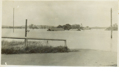
Kew Historical Society IncPhotograph, Flooding at Chipperfield's Boathouse, 1934
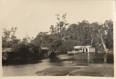
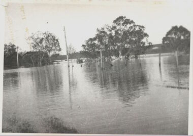
... Chipperfield's Boathouse and the adding Moorings was located beside the Yarra River near the corner of Willsmere and Kilby Roads. ...Numerous photographs record flooding throughout the Twentieth Century. floods (kew) floods (kew) 1934 yarra river Floods in North Kew, 1934. Chipperfield's Boathouse and the adding Moorings was located beside the Yarra River near the corner of Willsmere and Kilby Roads. ...Living with natural processes was frequently a challenge to early European settlers and later residents of what was in the 1850s administered by the Borondara Road Board. This was compounded by the area being bounded on three sides by rivers (Yarra River, Koonung Creek and Gardiner's Creek). In 1849, the historian James Bonwick recorded that "our district [Kew] suffered considerably. Mr Wade speaks of 80 acres, out of 100 acres of his cultivated paddock, covered by water." Newspapers continued to describe major flooding in Kew in 1863, 1869, 1878, 1880, 1889, 1891, 1916 and 1934. While the construction of the Upper Yarra dam in 1957 reduced the levels of flowing downstream, local and riverine floods continue.The Kew Historical Society's pictures and map collections testify to the impact of flooding in the district. They have historical importance in documenting the extent of flooding in the district and its affects on homes, services and recreation. Numerous photographs record flooding throughout the Twentieth Century.Floods in North Kew, 1934. Chipperfield's Boathouse and the adding Moorings was located beside the Yarra River near the corner of Willsmere and Kilby Roads. The flood reached the roof of the Moorings, which can be seen in the photo.floods (kew), floods (kew) 1934, yarra river -
 Kew Historical Society Inc
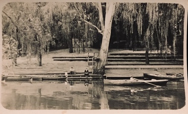
Photograph, Chipperfield's Boat House & Floating Pontoon, 1934
... yarra river...chipperfield's boathouse...River Yarra at Kew. Chipperfield's Boat House was located on the Yarra near the corner of Kilby and Willsmere Roads. The Kew Historical Society's pictures and map collections testify to the impact of flooding in the district. They have historical importance in documenting the extent of flooding in the district and its affects on homes, services and recreation. Numerous photographs record flooding throughout the Twentieth Century. yarra river chipperfield's boathouse ...Living with natural processes was frequently a challenge to early European settlers and later residents of what was in the 1850s administered by the Borondara Road Board. This was compounded by the area being bounded on three sides by rivers (Yarra River, Koonung Creek and Gardiner's Creek). In 1849, the historian James Bonwick recorded that "our district [Kew] suffered considerably. Mr Wade speaks of 80 acres, out of 100 acres of his cultivated paddock, covered by water." Newspapers continued to describe major flooding in Kew in 1863, 1869, 1878, 1880, 1889, 1891, 1916 and 1934. While the construction of the Upper Yarra dam in 1957 reduced the levels of flowing downstream, local and riverine floods continue. A number of boat houses operated on both sides of the River Yarra at Kew. Chipperfield's Boat House was located on the Yarra near the corner of Kilby and Willsmere Roads.The Kew Historical Society's pictures and map collections testify to the impact of flooding in the district. They have historical importance in documenting the extent of flooding in the district and its affects on homes, services and recreation. Numerous photographs record flooding throughout the Twentieth Century.Floating pontoon at Chipperfield's Boat House where the canoes were stored, taken in 1934, presumably before the 1934 Flood. This area of the Yarra was shallow with a number of mid river sandbanks and a popular swimming area for locals.yarra river, chipperfield's boathouse, pontoon -
 Kew Historical Society Inc
Photograph, Willsmere Bridge, 1934
... boathouses were built in Kew and Fairfield in the late 19th and early 20th centuries. They included Chipperfield’s ‘Moorings’ and floating pontoon. The substantial two-storey house was named the Moorings, and incorporated an upper storey residence. The Moorings was almost washed away in the 1916 floods, and in 1934 almost totally submerged when the Yarra River...boathouses were built in Kew and Fairfield in the late 19th and early 20th centuries. They included Chipperfield’s ‘Moorings’ and floating pontoon. The substantial two-storey house was named the Moorings, and incorporated an upper storey residence. The Moorings was almost washed away in the 1916 floods, and in 1934 almost totally submerged when the Yarra River ...Several boathouses were built in Kew and Fairfield in the late 19th and early 20th centuries. They included Chipperfield’s ‘Moorings’ and floating pontoon. The substantial two-storey house was named the Moorings, and incorporated an upper storey residence. The Moorings was almost washed away in the 1916 floods, and in 1934 almost totally submerged when the Yarra River rose 26 feet in 14 hours. Following the 1934 flood, the house was restored. The floating pontoon, sometimes referred to as a ‘kiosk’ or ‘canteen’, was used to store canoes. Both were removed in 1972 for the construction of the Eastern Freeway.This work forms part of the collection assembled by the historian Dorothy Rogers, that was donated to the Kew Historical Society by her son John Rogers in 2015. The manuscripts, photographs, maps, and documents were sourced by her from both family and local collections or produced as references for her print publications. Many were directly used by Rogers in writing ‘Lovely Old Homes of Kew’ (1961) and 'A History of Kew' (1973), or the numerous articles on local history that she produced for suburban newspapers. Most of the photographs in the collection include detailed annotations in her hand. The Rogers Collection provides a comprehensive insight into the working habits of a historian in the 1960s and 1970s. Together it forms the largest privately-donated collection within the archives of the Kew Historical Society.A view of flooded areas in North Kew in the flood of 1934.Willsmere Bridge. Chipperfields. 1934 floodwillsmere, flood, yarra flood, chipperfields, chipperfields boathouse, north kew -
 Kew Historical Society Inc
Photograph, Chipperfield's Boat House & Floating Pontoon, c.1939
... boathouses were built in Kew and Fairfield in the late 19th and early 20th centuries. They included Chipperfield’s ‘Moorings’ and floating pontoon. The substantial two-storey house was named the Moorings, and incorporated an upper storey residence. The Moorings was almost washed away in the 1916 floods, and in 1934 almost totally submerged when the Yarra River...boathouses were built in Kew and Fairfield in the late 19th and early 20th centuries. They included Chipperfield’s ‘Moorings’ and floating pontoon. The substantial two-storey house was named the Moorings, and incorporated an upper storey residence. The Moorings was almost washed away in the 1916 floods, and in 1934 almost totally submerged when the Yarra River ...Several boathouses were built in Kew and Fairfield in the late 19th and early 20th centuries. They included Chipperfield’s ‘Moorings’ and floating pontoon. The substantial two-storey house was named the Moorings, and incorporated an upper storey residence. The Moorings was almost washed away in the 1916 floods, and in 1934 almost totally submerged when the Yarra River rose 26 feet in 14 hours. Following the 1934 flood, the house was restored. The floating pontoon, sometimes referred to as a ‘kiosk’ or ‘canteen’, was used to store canoes. Both were removed in 1972 for the construction of the Eastern Freeway.This work forms part of the collection assembled by the historian Dorothy Rogers, that was donated to the Kew Historical Society by her son John Rogers in 2015. The manuscripts, photographs, maps, and documents were sourced by her from both family and local collections or produced as references for her print publications. Many were directly used by Rogers in writing ‘Lovely Old Homes of Kew’ (1961) and 'A History of Kew' (1973), or the numerous articles on local history that she produced for suburban newspapers. Most of the photographs in the collection include detailed annotations in her hand. The Rogers Collection provides a comprehensive insight into the working habits of a historian in the 1960s and 1970s. Together it forms the largest privately-donated collection within the archives of the Kew Historical Society.Chipperfield's Floating Canteen (also known as the pontoon) on the Yarra River. at North Kew The children wading in the river are believed to be the three sons of Dorothy Rogers."Chipperfield's Floating Canteen & house in background. At extreme right - observe channel where Connors Creek flows in."chipperfield's boat house, river yarra, dorothy rogers, floods 1916, 1934 -
 Kew Historical Society Inc
Journal, Kew Historical Society, Newsletter No.138, March 2022
... River: Macauley's Boathouse / Julie King p5. What's A Quoll? - lively and appealing squirrel-like spotted cats / Suzanne McWha p7. In March 1922 / Trove p8. A Coronation Dress: from Westminster Abbey to Kew / Suzanne McWha & Felicity Renowden p9. The Yarra ...Exhibitions and grants / Robert Baker p1. Office Bearers / p2. History News: acquisitions; Victorian Collections; grants & sponsors; 2022 McIntyre Lecture / p3. Madford: a former mansion in Wellington Street / Robert Baker p4. Life on the River: Macauley's Boathouse / Julie King p5. What's A Quoll? - lively and appealing squirrel-like spotted cats / Suzanne McWha p7. In March 1922 / Trove p8. A Coronation Dress: from Westminster Abbey to Kew / Suzanne McWha & Felicity Renowden p9. The Yarra Yarra Jazz Band / Brad Miles p11. Membership & Donations p12.Published quarterly since 1977, the newsletters of the Kew Historical Society contain significant research by members exploring relevant aspects of the Victorian and Australian Framework of Historical Themes. Frequently, articles on people, places and artefacts are the only source of information about an aspect of Kew, and Melbourne’s history.non-fictionExhibitions and grants / Robert Baker p1. Office Bearers / p2. History News: acquisitions; Victorian Collections; grants & sponsors; 2022 McIntyre Lecture / p3. Madford: a former mansion in Wellington Street / Robert Baker p4. Life on the River: Macauley's Boathouse / Julie King p5. What's A Quoll? - lively and appealing squirrel-like spotted cats / Suzanne McWha p7. In March 1922 / Trove p8. A Coronation Dress: from Westminster Abbey to Kew / Suzanne McWha & Felicity Renowden p9. The Yarra Yarra Jazz Band / Brad Miles p11. Membership & Donations p12.kew historical society (vic.) -- periodicals., kew historical society (vic.) -- newsletters, kew historical society (vic.) -- journals -
 Kew Historical Society Inc
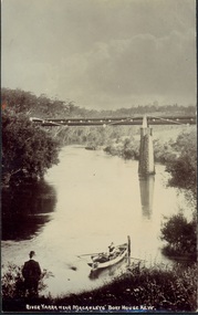
Postcard, River Yarra near Macauleys' Boathouse Kew, c.1910
... River Yarra near Macauleys' Boathouse Kew...yarra river -- kew (vic.) pipe bridge Obverse: "River Yarra near Macauleys' Boat House Kew". Reverse: "(Pipe Water Line) / Kew to Fairfield above boat house / Pipe Bridge / Received from L. Bennett 1980". Early sepia real photo postcard of the first Pipe Bridge bringing water from the Yan Yean Reservoir to Kew. The site is upriver of the original Macauley's boathouse ...The Pipe Bridge was constructed to bring fresh water from Fairfield to Kew. This bridge was destroyed in the 1934 Flood and later reconstructed.Early sepia real photo postcard of the first Pipe Bridge bringing water from the Yan Yean Reservoir to Kew. The site is upriver of the original Macauley's boathouse. Obverse: "River Yarra near Macauleys' Boat House Kew". Reverse: "(Pipe Water Line) / Kew to Fairfield above boat house / Pipe Bridge / Received from L. Bennett 1980".bridges - kew (vic.), bridges - yarra river -- kew (vic.), pipe bridge -
 Kew Historical Society Inc
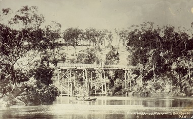
Postcard, J.W.K. & Co, River Yarra near Macauleys' Boathouse Kew, c.1910
... River Yarra near Macauleys' Boathouse Kew...Obverse: "River Yarra near Macauleys' Boathouse Kew". Reverse: "Gift from L Bennett"...Bridges -- river yarra bridges - kew (vic.) zig-zag bridge Obverse: "River Yarra near Macauleys' Boathouse Kew". ...The Zig-Zag Bridge which was constructed in the 1870s to link the Yarra Bend Asylum and Kew Asylum. Initially it transported bluestone from the west side of the Yarra to the east during the construction of the Kew Asylum.Real photo postcard of the Zig-Zag Bridge at Kew. In the middle ground there is a rowboat.Obverse: "River Yarra near Macauleys' Boathouse Kew". Reverse: "Gift from L Bennett"bridges -- river yarra, bridges - kew (vic.), zig-zag bridge -
 Kew Historical Society Inc
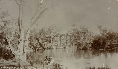
Postcard, River Yarra near Macauleys' Boathouse Kew
... River Yarra near Macauleys' Boathouse Kew...Obverse: "River Yarra near Macauleys' Boathouse Kew". Reverse: "Zig Zag Bridge / Gift from L Bennett 1980 / Bridge between Old Asylum & new Mental Hosp. / Kew side"...Bridges -- river yarra bridges -- kew (Vic.) Obverse: "River Yarra near Macauleys' Boathouse Kew". ...Sepia postcard of the Zig-zaf Bridge joining Yarra Bend and Studley Park. In the foreground is a rowboat in which a man is standing, behind whom are two women in hats and a young child. The man appears to be pushing the boat away from the Bank. In the distance is the wooden Zig-Zag Bridge, constructed in the 1870s to link the Yarra Bend and Kew Lunatic Asylums. [Destroyed by flood, 1929.]Obverse: "River Yarra near Macauleys' Boathouse Kew". Reverse: "Zig Zag Bridge / Gift from L Bennett 1980 / Bridge between Old Asylum & new Mental Hosp. / Kew side"zig-zag bridge -- kew (vic.), bridges -- river yarra, bridges -- kew (vic.) -
 Kew Historical Society Inc
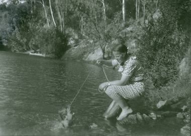
Photograph - Mother and child at the Yarra River, Kew, 1950s
... Canoeing on the River Yarra was a recreational traditional pastime for the people of Kew and Melbourne since settlement in the 1830s. Later in the century, canoes were frequently hired from boathouses....Kew Historical Society Inc Kew Court House 188 High Street Kew melbourne Canoeing on the River Yarra was a recreational traditional pastime for the people of Kew and Melbourne since settlement in the 1830s. Later in the century, canoes were frequently hired from boathouses. ...Canoeing on the River Yarra was a recreational traditional pastime for the people of Kew and Melbourne since settlement in the 1830s. Later in the century, canoes were frequently hired from boathouses.Print enlargement. Woman beside river holding a piece of string. Child swimming in Yarra. Canoe in distance beside bank with passengers.Reverse: "M Holmes"recreation -- canoeing, yarra river -- kew -
 Kew Historical Society Inc
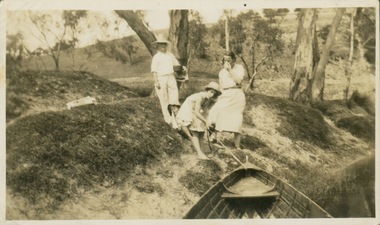
Photograph - Picnic beside the Yarra at Kew, 1938
... Rowing on the River Yarra was a recreational traditional pastime for the people of Kew and Melbourne since settlement in the 1830s. Later in the century, boats were frequently hired from boathouses....Kew Historical Society Inc Kew Court House 188 High Street Kew melbourne Rowing on the River Yarra was a recreational traditional pastime for the people of Kew and Melbourne since settlement in the 1830s. Later in the century, boats were frequently hired from boathouses. ...Rowing on the River Yarra was a recreational traditional pastime for the people of Kew and Melbourne since settlement in the 1830s. Later in the century, boats were frequently hired from boathouses.Three people beside the Yarra. Teenage girl (?) pulling a row boat towards the shore. Photo taken from boat. Sparse riverside vegetation. Reverse: "Jan 38"river yarra, recreation -- rowing -
Kew Historical Society Inc
Booklet - Old Kew Golf Links Estate, 1926
... Boathouse (aka Chipperfield's Boat House). The aerial photograph, overlaid with names of notable sites, on the final page is of interest as it shows the area before the intrusion of the Eastern Freeway, which resulted in changing the course of a section of the Yarra River. ...Boathouse (aka Chipperfield's Boat House). The aerial photograph, overlaid with names of notable sites, on the final page is of interest as it shows the area before the intrusion of the Eastern Freeway, which resulted in changing the course of a section of the Yarra River. ...Subdivision plans and real estate flyers/brochures reveal a number of aspects of urban development and history. The Kew Historical Society's collection of these plans, as well as advertisements extracted from magazines, cover key aspects of community development and architectural history of Kew and Kew Eat as well as surrounding suburbs. While most of the plans in the collection were gifted to the Society by the former City of Kew, a number of other plans and advertisements have been donated by individuals, of which this is an example.8-page brochure advertising 80 residential home sites for sale in a subdivision called the 'Old Kew Golf Links Estate'. These sites had historic importance in Kew's history as they had previously belonged to Kodak Pty Ltd who were refused permission by Kew Council to use the land for industrial development. The estate, advertised was advertised as being within five miles of Melbourne. The brochure is notable as it includes photographs of Kew East Primary School, the former Kew Golf Club clubhouse, and 'The Moorings' Boathouse (aka Chipperfield's Boat House). The aerial photograph, overlaid with names of notable sites, on the final page is of interest as it shows the area before the intrusion of the Eastern Freeway, which resulted in changing the course of a section of the Yarra River. old kew golf links estate, subdivision -- kew (vic.), subdivisions -- kew east (vic), chipperfield's boathouse, kew east primary school, kew golf club -
 Kew Historical Society Inc
Photograph - Flooding of the Yarra River in North Kew, 1934
... yarra river -- north kew...floods -- yarra valley...floods -- north kew...floods -- 1934...natural disasters -- kew...chipperfields boathouse...Yarra River. As such, it was a region subject to flooding in the Yarra Valley. Development beyond this point (ie Kellett Grove) was limited by the City of Kew's planning regulations. Prior to urban development, the area since European settlement and the first land sales in the district in the 1840s, had been used for dairy farming. . yarra river -- north kew floods -- yarra valley floods -- north kew floods -- 1934 natural disasters -- kew chipperfields boathouse Verso: THIS IS CHIPPERFIELD'S BOAT SHEDS & COES & WILLIAMS TAKEN FROM OUR STREET / 1934 Small sepia snapshot of the devastation caused by the 1934 flood.The photo was taken in the vicinity of Kellett Grove, North Kew and includes the roof of Chipperfield's Boathouse as well as other local houses. ...North Kew, now divided between Kew and Kew East, bordered the Yarra River. As such, it was a region subject to flooding in the Yarra Valley. Development beyond this point (ie Kellett Grove) was limited by the City of Kew's planning regulations. Prior to urban development, the area since European settlement and the first land sales in the district in the 1840s, had been used for dairy farming. .Small sepia snapshot of the devastation caused by the 1934 flood.The photo was taken in the vicinity of Kellett Grove, North Kew and includes the roof of Chipperfield's Boathouse as well as other local houses.Verso: THIS IS CHIPPERFIELD'S BOAT SHEDS & COES & WILLIAMS TAKEN FROM OUR STREET / 1934yarra river -- north kew, floods -- yarra valley, floods -- north kew, floods -- 1934, natural disasters -- kew, chipperfields boathouse -
 Kew Historical Society Inc
Photograph - Kew Boat Sheds [Macauley's Boathouse], Henry Beater Christian, 1920s
... boathouse...yarra river -- kew (vic.)...An item from an outstanding and diverse photographic collection, assembled by members of the Christian and Washfold families of Kew. macauley's boathouse yarra river -- kew (vic.) christian-washfold collection View of grounds of Macauleys boathouse. ...Henry Christian (c.1809-91), the grandfather of the photographer, was one of the first settlers in Kew. He arrived in Victoria with his wife Agnes and son Orlando in 1855 on the Gypsy Queen. He established a rope-making business in Bulleen Road by 1858 but was declared insolvent two years later. In his final years, he was celebrated as one of the oldest living settlers of the district. His son, Orlando Henry Beater Christian (c.1853-1930) became a member of the Hawthorn Band and a foundation member of the Willsmere Swimming Club. Orlando and his wife Elizabeth had four children of which Henry Beater Christian (1886-1962) was the eldest.An item from an outstanding and diverse photographic collection, assembled by members of the Christian and Washfold families of Kew.View of grounds of Macauleys boathouse. Gum trees and willows. Stacked embankment. Person rowing boat. Others sitting on bank.macauley's boathouse, yarra river -- kew (vic.), christian-washfold collection -
 Kew Historical Society Inc
Album - Photograph Album No.1, Henry Beater Christian, 1924-26
... yarra river...kew (vic.) — zig-zag bridge...kew (vic.) — macauley’s boathouse....) — yarra river kew (vic.) — zig-zag bridge kew (vic.) — macauley’s boathouse studley park (vic.) — yarra river wonderland — grampians (vic.) black spur (vic.) marysville (vic.) maroondah dam (vic.) — construction warburton (vic.) cockatoo (vic.) bruthen (vic.) swan reach road (vic.) glen hills (vic.) lightning creek (vic.) omeo (vic.) glen wills (vic.) mt wills (vic.) sunnyside (vic) granite flat (vic.) toolangi (vic.) yea (vic ). flowerdale (vic.) mt white law (vic.) baw baw (vic.) christian-washfold collection Digital copy of a 47-page photograph album containing 255 gelatinous silver images, loaned by Diane Washfold with permission given to digitise and hold a copy in our collection. ...Henry Christian (c.1809-91), the grandfather of the photographer, was one of the first settlers in Kew. He arrived in Victoria with his wife Agnes and son Orlando in 1855 on the Gypsy Queen. He established a rope-making business in Bulleen Road by 1858 but was declared insolvent two years later. In his final years, he was celebrated as one of the oldest living settlers of the district. His son, Orlando Henry Beater Christian (c.1853-1930) became a member of the Hawthorn Band and a foundation member of the Willsmere Swimming Club. Orlando and his wife Elizabeth had four children of which Henry Beater Christian (1886-1962) was the oldest.An album of photographs, compiled by Henry Beater Christian (1886-1962) of Pakington Street, Kew, depicting individuals, natural and settled environments and the interactions between these worlds. Henry Christian, was a keen explorer, not just of his immediate environment but also of the Victorian wilderness. His major opus is contained in two albums in which he records, sometimes in majestic detail and on other occasions the intimate features of the natural world. His photographic travels during the 1920s, often in solitary ramblings but on other occasions with companions, recall the heroic landscape photography of an earlier era, pioneered by Nicholas Caire. In addition to their aesthetic value, the albums are historically significant records within the State of Victoria, of what is now a distant point in time, and of places that have become radically altered through human intervention.Digital copy of a 47-page photograph album containing 255 gelatinous silver images, loaned by Diane Washfold with permission given to digitise and hold a copy in our collection. The album contains a groups of photographic positives taken by Henry B Christian (a resident of Pakington Street), of places in Kew and throughout regional Victoria during the 1920s. The mainly sepia photographs, while small, are of a high quality. Photographs are typically lightly glued onto pages. Locations are frequently identified by white or black ink, which in a number of cases is illegible due to wear. Readable named locations include: Kew, the Grampians, Marysville, Baw Baw, Daylesford, Hepburn Springs, Bruthen, Swan Reach, Yea, Flowerdale, Port Fairy, Cockatoo, etc.henry beater christian (1886-1962), landscape photography, photograph albums, kew (vic.) — yarra river, kew (vic.) — zig-zag bridge, kew (vic.) — macauley’s boathouse, studley park (vic.) — yarra river, wonderland — grampians (vic.), black spur (vic.), marysville (vic.), maroondah dam (vic.) — construction, warburton (vic.), cockatoo (vic.), bruthen (vic.), swan reach road (vic.), glen hills (vic.), lightning creek (vic.), omeo (vic.), glen wills (vic.), mt wills (vic.), sunnyside (vic), granite flat (vic.), toolangi (vic.), yea (vic, )., flowerdale (vic.), mt white law (vic.), baw baw (vic.), christian-washfold collection