Showing 11 items matching "bonbeach"
-
 City of Kingston
Photograph - Colour, 29 January 1993
... Bonbeach...Bonbeach is a small beachside suburb located between Chelsea and Carrum. ...Landmarks include St Joseph's Church and Primary School, Chelsea Primary School, Bonbeach Station, Bonbeach Fotball Club sports playing fields and Bonbeach Life Saving Club. ...City of Kingston Parkdale Library 96 Parkers Road, Parkdale Parkdale Bonbeach is a small beachside suburb located between Chelsea and Carrum. ...Bonbeach is a small beachside suburb located between Chelsea and Carrum. The station was opened in 1926 and was the last to be established in the group from Aspendale to Carrum. Urban growth began after World War II. State primary and high schools were opened in 1958 on land in Breeze Street that was once occupied by The Australian Glass Manufacturers. Immediately east of the school sites is the Patterson River Golf Club. The Bonbeach sports reserve has five ovals and is home to the Bonbeach football and baseball clubs. The suburb borders the Edithvale-Seaford Wetlands which is the remnant site of the Carrum Carrum swamp, once the home of the Bunurong people.Bonbeach was originally a seaside destination for holidaymakers and the housing comprised of holiday homes and gradually more permanent residents. It was not until 1926 that Bonbeach had its own railway station. From 1906 until the late 1940s sand was quarried on the east side of the railway line and used in the manufacture of glass. The Australian Glass Manufacturers sold this land in residential blocks and Bonbeach's permanent population spread from the coastal strip across to the other side of the railway line. Laminated colour aerial photograph of the suburb of Bonbeach and also the southern section of neighbouring Chelsea within the City of Kingston. The extent of this 1993 aerial image includes: Top left - Maury Road at the south end of the Chelsea shopping Centre; Top right - Scotch Parade Chelsea Bottom left - Monica Avenue in Bonbeach; Bottom right - Patterson River Golf Club. Landmarks include St Joseph's Church and Primary School, Chelsea Primary School, Bonbeach Station, Bonbeach Fotball Club sports playing fields and Bonbeach Life Saving Club. The Edithvale Wetlands is featured prominently to the right-hand side of the image. Black typed writing on white adhesive label: No. 6662 Black typed writing on white adhesive label: 26E/6662, 29/1/93, 4.25 pm Black typed writing on white adhesive label: 29-1-93 Black typed writing on white adhesive label: P000109 Circular yellow adhesive sticker bonbeach, chelsea -
City of Kingston
Photograph - Colour, 29 January 1993
... Bonbeach...Bonbeach, Carrum and Patterson Lakes are suburbs in the City of Kingston. ...This 1993 image includes Bonbeach High School prior to demolition, Bonbeach Primary School and Patterson River Golf Club. ...City of Kingston Parkdale Library 96 Parkers Road, Parkdale Parkdale Bonbeach, Carrum and Patterson Lakes are suburbs in the City of Kingston. ...Bonbeach, Carrum and Patterson Lakes are suburbs in the City of Kingston. Bonbeach and Carrum were holiday destinations in early 20th century and over time the housing has converted to permanent residential structures. In Patterson Lakes, the area consists predominantly of newer housing developments and the tidal canal system which is accessible to many dwellings joins Port Phillip Bay.Bonbeach, Carrum and Patterson Lakes were previously part of the extensive Carrum Carrum Swamp. The area was once a source of fish and eels for the Mayone-Bulluk clan of the Bunurong people. Over time the area was drained and this allowed farming at Carrum and Bonbeach, although the area was prone to flooding. In the early 1920s and 30s the land was converted to residential dwellings. In 1973 investigations commenced nearby to Bonbeach and Carrum into the development of a unique residential area comprising canals and waterways. It was originally proposed to be known as "Gladesville". Circa 1974, the area was rezoned from rural to residential and named Patterson Lakes. Development has been continuous since the 1970s with staged construction of the waterways, residential housing, and supporting infrastructure and facilities.Laminated colour aerial photograph of the Bonbeach, Carrum and Patterson Lakes region within City of Kingston. This 1993 image includes Bonbeach High School prior to demolition, Bonbeach Primary School and Patterson River Golf Club. Sections of Patterson Lakes are not yet developed, including Rhode and Staten Islands. Long Island Point appears to be a recent development with many spare blocks and new houses under construction. The Patterson River marina is prominent and the river mouth as it meets Port Phillip Bay. The Carrum railway station is visible.Black type on white adhesive sticker: No. 6661 Black type on white adhesive sticker: 26E/6661, 29/1/93, 4.25 pm Black type on white adhesive sticker 29-1-93 Yellow circular adhesive stickerbonbeach, carrum, patterson lakes, patterson river, carrum carrum swamp, canals and waterways -
 City of Kingston
Photograph - Colour, July 2000
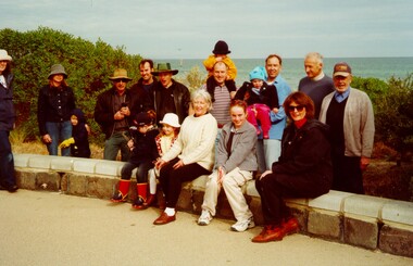
... Bonbeach...This photograph depicts workers/volunteers who planted trees on foreshore at Bonbeach & Carrum as part of National Tree Day. ...The group is a volunteer group who planted trees on the foreshore and Bonbeach and Carrum for National Tree Day. Councillor Topsy Petchey on right. ...City of Kingston Parkdale Library 96 Parkers Road, Parkdale Parkdale This photograph depicts workers/volunteers who planted trees on foreshore at Bonbeach & Carrum as part of National Tree Day. ...This photograph depicts workers/volunteers who planted trees on foreshore at Bonbeach & Carrum as part of National Tree Day. Councillor Topsy Petchey, OAM, is on the right.Colour photograph of a group people sitting on a low stone wall. The group is a mixture of ages, including very young children and the ocean is visible in the background. The group is a volunteer group who planted trees on the foreshore and Bonbeach and Carrum for National Tree Day. Councillor Topsy Petchey on right. Handwritten on reverse in black ink: National Tree Day / G Pet.bonbeach, carrum, ocean, trees, environment, volunteers, councillors -
 Chelsea & District Historical Society Inc
Book - The Fallen: From Chelsea and Carrum - printed 2014, Margaret Diggerson, The Fallen: From Chelsea and Carrum
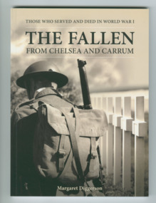
... Chelsea, Aspendale, Edithvale, Bonbeach and Carrum, Victoria ...Accounts of the lives of WW1 soldiers from Chelsea and districtSmall soft cover booknon-fictionAccounts of the lives of WW1 soldiers from Chelsea and districtlocal men of chelsea who served in ww1 -
 City of Kingston
Photograph - Colour, 30 July 2000
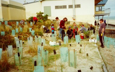
... Colour photograph of a group of people on Bonbeach foreshore with Bonbeach Life Saving Club in the background. ...Colour photograph of a group of people on Bonbeach foreshore with Bonbeach Life Saving Club in the background. ...This photograph depicts workers/volunteers participating in tree planting on the foreshore as part of National Tree Day. It is uncertain which beach is it.Colour photograph of a group of people on Bonbeach foreshore with Bonbeach Life Saving Club in the background. In front of the group are a many freshly planted trees surrounded by ground stakes and green plastic sheeting.Handwritten in black ink: National Tree Day / 30 July 2000 / Bon Beach? / Edithvale?ocean, trees, environment, volunteers -
 Melbourne Tram Museum
Negative - Marshalite traffic light Nepean Highway, Hugh Ballment, c1954
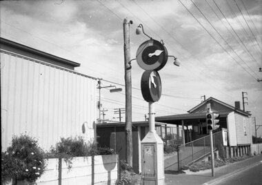
... The photograph shows a Marshalite traffic signal at a railway station along the Frankston line - such signals were provided at Chelsea, Bonbeach and Aspendale....Melbourne Tram Museum 8 Wallen Road Hawthorn melbourne The photograph shows a Marshalite traffic signal at a railway station along the Frankston line - such signals were provided at Chelsea, Bonbeach and Aspendale. Yields information about the Marshalite traffic lights installed at ? ...The photograph shows a Marshalite traffic signal at a railway station along the Frankston line - such signals were provided at Chelsea, Bonbeach and Aspendale.Yields information about the Marshalite traffic lights installed at ? station.Negative - 127 film black and whitetraffic lights, marshalite, railways, nepean highway -
 Chelsea & District Historical Society Inc
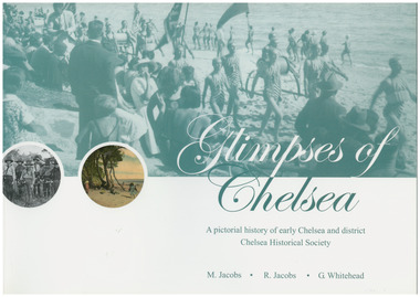
Book, G.Whitehead, Glimpses of Chelsea, 2007
... ...Bonbeach...Aspendale Carrum Bonbeach Edithvale Chelsea A pictorial history of early Chelsea & District first printed 2007 Large soft cover book Glimpses of Chelsea Book Book G.Whitehead M Jacobs R Jacobs ...Photos and descriptions of historical buildings Chelsea District Historical Society is fortunate to have many photos that have been donated and collated over the last fifty years. In the early years our beachside suburb was popular with groups and families. Camping & holidaying in guest houses or privately rented houses. This book includes photographs of local people, beaches, churches, clubs, sports, hotels, railways, industry, hospitals and halls, and many other pictures of local scenes. A unique history of the District of Chelsea. Photographs show the beginnings and how the Chelsea district was developed. Various Sporting clubs and groups, businesses, buildings, streets and early European settlers and others. Large soft cover book A pictorial history of early Chelsea & District first printed 2007aspendale, carrum, bonbeach, edithvale, chelsea -
 Chelsea & District Historical Society Inc
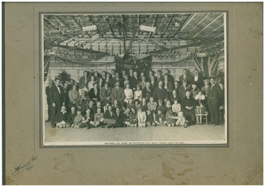
Photograph - Bon Beach Life Saving and Recreational Club, Queen Carnival Dance, 1932
... ...Bonbeach...Chelsea & District Historical Society Inc The Chelsea Activity Hub 3-5 Showers Ave Chelsea 3196 melbourne Queen's Carnival dance Bonbeach Life Saving Club Chelsea fashion entertainment D H Garrood Photo, Chelsea Black and white photo of the attendees, adults and children, of the Queen Carnival dance at Bon Beach Life Saving Club in July 1932. ...Black and white photo of the attendees, adults and children, of the Queen Carnival dance at Bon Beach Life Saving Club in July 1932. The Hall is decorated with streamers and flags.D H Garrood Photo, Chelseaqueen's carnival dance, bonbeach, life saving club, chelsea, fashion, entertainment -
 Vision Australia
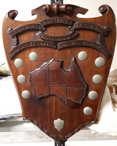
Photograph - Image, Inter-Club Gymnasium Competition
... The clubs that vied for this shield were the Trojans (from the RVIB), Bonbeach Surf and Life Saving Club and Beattie's Physical Culture School. ...The clubs that vied for this shield were the Trojans (from the RVIB), Bonbeach Surf and Life Saving Club and Beattie's Physical Culture School. ...The Conder Shield was sponsored by Major Wally Conder, a keen sportsman (amongst other occupations,) who sought to promote wrestling and boxing during his time as president of the Victorian Amateur Wrestling and Boxing Association. Presented to the winning club of the Inter-Club Gymnasium Competition, over a series of matches in individual athleticism. These included skipping, roller cycling and chinning bar, as well as light-weight, middle-weight and welter-weight wrestling. The clubs that vied for this shield were the Trojans (from the RVIB), Bonbeach Surf and Life Saving Club and Beattie's Physical Culture School. In 1934, the Trojans team consisted of Neil Westh, Charlie Bradley, A. McDonald, T. Hanlon, B. Cook and coach/captain V. Blucher. Mr Henry Vincent Blucher was a former police constable to lost his sight in 1931 due to a car accident, and who had previously held the title of Victorian novice middleweight. Metal plates on shield read: V.A.G.A. Inter-club gym contest 1933-34 Won by "Trojans" B.P.C.C. V.A.G.A. Inter-club gym contest 1935 Won by V.R.I. Gym Club Won by "Trojans" 1936 Won by "Trojans" 1937 Runners Up Bonbeach 1934 Runners Up Trojans 1935 Runners Up "Achilles" 1936 Runners Up "Achilles" 1937 Achilles Runners Up 1938 Presented by W.T. ConderImage of wooden shield with metal plaques and map of AustraliaInter-Club Gymnasium Competition conducted by Victorian Amateur Gymnasium Associationrecreation, royal victorian institute for the blind, awards -
 Sunshine and District Historical Society Incorporated
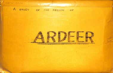
Archive - A Study Of The Region Of Ardeer, Sister Chanel (Sister Julia Williams), 1985
... Some years later, she was living at Unit 3, 387 Station Street, Bonbeach, Vic, 3196. Today, the Brigidine Convent at Ardeer no longer exists. ...Some years later, she was living at Unit 3, 387 Station Street, Bonbeach, Vic, 3196. Today, the Brigidine Convent at Ardeer no longer exists. ...Sister Chanel, was later known as Sister Julia Williams. She was professed on the 7th December 1963. She is mentioned in a history of the Brigidine Sister, by Morna Sturrock, Women of Strength, Women of Gentleness: Brigidine Sisters - Victoria Province, David Lovell Publishing, Victoria Australia, 1995, page 290. Sister Chanel (Sister Julia Williams) undertook a study of Ardeer in 1985, as part of her university studies. At the time, she was based at the Brigidine Convent in Blanche Street, Ardeer, opposite the Mother of God Catholic Primary School. Some years later, she was living at Unit 3, 387 Station Street, Bonbeach, Vic, 3196. Today, the Brigidine Convent at Ardeer no longer exists. The buildings have been demolished. The local schools begun by the Brigidine Sisters are now entirely staffed by lay teachers. There is a Brigidine Centre in Malvern, which contains archives relating to the Brigidine Sisters' history.The Brigidine Sisters (often misheard as “Bridiline”) are a long‑established Catholic religious congregation with a major historical presence in Melbourne, especially in education and social justice work. They arrived in Victoria in the 1880s and continue to operate schools, ministries, and community programs across the state.5384.01 - A Regional Study Of The Region Of Ardeer Envelope.jpg Text - A Regional Study Of The Region Of Ardeer 5384.02 - A Regional Study Of The Region Of Ardeer Page 1.jpg Text - A Regional Study Of The Region Of Ardeer 5384.02 - A Regional Study Of The Region Of Ardeer Page 2.jpg 5384.02 - A Regional Study Of The Region Of Ardeer Page 3.jpg Text - Subject HU211 Regionalism And Australia 5384.02 - A Regional Study Of The Region Of Ardeer Page 4.jpg Text - Ardeer Regions Selected 5384.02 - A Regional Study Of The Region Of Ardeer Page 5.jpg Melway Map 5384.02 - A Regional Study Of The Region Of Ardeer Page 6.jpg Text - Ardeer Never Heard Of It. Wheres That? 5384.02 - A Regional Study Of The Region Of Ardeer Page 7.jpg Text - Study The Region of Ardeer. There's Northing To Study 5384.02 - A Regional Study Of The Region Of Ardeer Page 8.jpg 1978 Municipal Directory 5384.02 - A Regional Study Of The Region Of Ardeer Page 9.jpg Text - Who Fosters It Image - House 5384.02 - A Regional Study Of The Region Of Ardeer Page 10.jpg Image - Market Gardens Yallourn Street Image - Yallourn Street 5384.02 - A Regional Study Of The Region Of Ardeer Page 11.jpg Image - Mother Of God Catholic Church Blanche Street Image - Mother Of God Catholic Church Blanche Street 5384.02 - A Regional Study Of The Region Of Ardeer Page 12.jpg Image - Scotch Thistles Image - Kororoit Creek Bridge West Street To Esmond Street 5384.02 - A Regional Study Of The Region Of Ardeer Page 13.jpg Image - Kororoit Creek Bridge Yalloun Street to Ballarat Road Image - Mother Of God Catholic Church Blanche Street 5384.02 - A Regional Study Of The Region Of Ardeer Page 14.jpg Text - Councillors, Politicians, People 5384.02 - A Regional Study Of The Region Of Ardeer Page 15.jpg Reality 5384.02 - A Regional Study Of The Region Of Ardeer Page 16.jpg Text - Geography Of The City Of Sunshine 5384.02 - A Regional Study Of The Region Of Ardeer Page 18.jpg Melway Map 5384.02 - A Regional Study Of The Region Of Ardeer Page 20.jpg Image - Kororoit Creek From Ballarat Road 5384.02 - A Regional Study Of The Region Of Ardeer Page 22.jpg Text - Basalt Sample Of A Basalt Rock When Laying Foundations For The Polish Community Hall In Helene Street 5384.02 - A Regional Study Of The Region Of Ardeer Page 23.jpg Image - Corner Yallourn Street And Rockbank Road Image - Tower Road Proposed Freeway Site (Now Scrapped) 5384.02 - A Regional Study Of The Region Of Ardeer Page 24.jpg Image - Kororoit Creek Bridge West Street To Esmond Street 5384.02 - A Regional Study Of The Region Of Ardeer Page 25.jpg Kororoit Creek Bridge West Street To Esmond Street 5384.02 - A Regional Study Of The Region Of Ardeer Page 26.jpg Image - Sunshine Swimming Pool Kororoit Creek 5384.02 - A Regional Study Of The Region Of Ardeer Page 27.jpg Text - Industry 5384.02 - A Regional Study Of The Region Of Ardeer Page 28.jpg Text - ICI 5384.02 - A Regional Study Of The Region Of Ardeer Page 29.jpg Text - ICINZ 5384.02 - A Regional Study Of The Region Of Ardeer Page 30.jpg Image - ICIANZ Ballarat Road Entrance 1979 Image - ICIANZ Explosive Reserve View From More Park Esmond Road 5384.02 - A Regional Study Of The Region Of Ardeer Page 31.jpg Image - Forrest Street Corner Fitzgerald Road Image - Entrance To ICIANZ Forrest Street 5384.02 - A Regional Study Of The Region Of Ardeer Page 32.jpg Image - Explosive Train Shunting Across Forrest Street 5384.02 - A Regional Study Of The Region Of Ardeer Page 33.jpg Image - Besco Batteries Forrest Street 5384.02 - A Regional Study Of The Region Of Ardeer Page 34.jpg Image - Queen Of Heaven Catholic Church Holt Street 5384.02 - A Regional Study Of The Region Of Ardeer Page 35.jpg Image - Ukrainian Catholic Church Forrest Street 5384.02 - A Regional Study Of The Region Of Ardeer Page 36.jpg Image - Mother Of God Catholic Church Blanche Street 5384.02 - A Regional Study Of The Region Of Ardeer Page 37.jpg Image - Ukrainian Hall Suspension Street Image - Polish Hall Helene Street 5384.02 - A Regional Study Of The Region Of Ardeer Page 38.jpg Image - Mother Of God Catholic Primary School Blanche Street 5384.02 - A Regional Study Of The Region Of Ardeer Page 39.jpg Image - Ardeer State School Looking From Suspension Street 5384.02 - A Regional Study Of The Region Of Ardeer Page 40.jpg Image - Polish Soccer Club Playgroup 5384.02 - A Regional Study Of The Region Of Ardeer Page 41.jpg Image - Holt Street Shopping Centre Image - Holt Street Milk Bar And Post Office 5384.02 - A Regional Study Of The Region Of Ardeer Page 42.jpg Image - 29 - 31 Maxwell Street Shopping Centre Image - 60 - 62 Maxwell Street Shopping Centre 5384.02 - A Regional Study Of The Region Of Ardeer Page 43.jpg Image - Motor Rail Train At Ardeer Station 5384.02 - A Regional Study Of The Region Of Ardeer Page 44.jpg Image - Ardeer Railway Station 5384.02 - A Regional Study Of The Region Of Ardeer Page 45.jpg Image - Railway Line Pedestrian Crossing Ardeer Station Ridgeway Parade To Forrest Street Image - Railway Line Pedestrian Crossing Ridgeway Parade To West Street 5384.02 - A Regional Study Of The Region Of Ardeer Page 46.jpg Image - Half House Image - Half House 5384.02 - A Regional Study Of The Region Of Ardeer Page 47.jpg Image - Small House Image - Vacant Block 5384.02 - A Regional Study Of The Region Of Ardeer Page 48.jpg Image - House Image - New House 5384.02 - A Regional Study Of The Region Of Ardeer Page 49.jpg Image - House 5384.02 - A Regional Study Of The Region Of Ardeer Page 50.jpg Image - Horse Riding School Forrest Street Image - Horse Riding School Forrest Street 5384.02 - A Regional Study Of The Region Of Ardeer Page 51.jpg Image - Kororoit Creek Image - Playground 5384.02 - A Regional Study Of The Region Of Ardeer Page 52.jpg Image - More Park Women's Sport Centre Esmond Street Image - Old Service Station Old Service Station 5384.02 - A Regional Study Of The Region Of Ardeer Page 53.jpg Image - Vegetable Garden Image - Vegetable Garden 5384.02 - A Regional Study Of The Region Of Ardeer Page 54.jpg Text - Open Space Analysis 5384.02 - A Regional Study Of The Region Of Ardeer Page 55.jpg 1976 Census 5384.02 - A Regional Study Of The Region Of Ardeer Page 56.jpg 1976 Census 5384.02 - A Regional Study Of The Region Of Ardeer Page 57.jpg 1979 Statistics 5384.02 - A Regional Study Of The Region Of Ardeer Page 58.jpg Text - Some Significant Realities 5384.02 - A Regional Study Of The Region Of Ardeer Page 59.jpg Text - A Typical Story From An Ardeerite 5384.02 - A Regional Study Of The Region Of Ardeer Page 60.jpg Text - Bibliography 5384.03 - A Regional Study Of The Region Of Ardeer - Donation Letter.jpg 5384.04 - A Regional Study Of The Region Of Ardeer - Sister Chanel Details.jpg -
 Sunshine and District Historical Society Incorporated
Photograph - Images of Ardeer By Sister Chanel, Sister Chanel (Sister Julia Williams), 1980's
... Some years later, she was living at Unit 3, 387 Station Street, Bonbeach, Vic, 3196. These photographs have been scanned from her university work "A Study Of The Region Of Ardeer" Today, the Brigidine Convent at Ardeer no longer exists. ...Some years later, she was living at Unit 3, 387 Station Street, Bonbeach, Vic, 3196. These photographs have been scanned from her university work "A Study Of The Region Of Ardeer" Today, the Brigidine Convent at Ardeer no longer exists. ...Sister Chanel, was later known as Sister Julia Williams. She was professed on the 7th December 1963. She is mentioned in a history of the Brigidine Sister, by Morna Sturrock, Women of Strength, Women of Gentleness: Brigidine Sisters - Victoria Province, David Lovell Publishing, Victoria Australia, 1995, page 290. Sister Chanel (Sister Julia Williams) undertook a study of Ardeer in 1985, as part of her university studies. At the time, she was based at the Brigidine Convent in Blanche Street, Ardeer, opposite the Mother of God Catholic Primary School. Some years later, she was living at Unit 3, 387 Station Street, Bonbeach, Vic, 3196. These photographs have been scanned from her university work "A Study Of The Region Of Ardeer" Today, the Brigidine Convent at Ardeer no longer exists. The buildings have been demolished. The local schools begun by the Brigidine Sisters are now entirely staffed by lay teachers. There is a Brigidine Centre in Malvern, which contains archives relating to the Brigidine Sisters' history.These black & white photographs capture Ardeer's street scenes and other points of interest in the 1980's5383.01 - Images of Ardeer By Sister Chanel - Holt Street Shopping Centre.jpg 5383.02 - Images of Ardeer By Sister Chanel - Holt Street Milk Bar And Post Office.jpg 5383.03 - Images of Ardeer By Sister Chanel - 29 - 31 Maxwell Street Shopping Centre.jpg 5383.04 - Images of Ardeer By Sister Chanel - 60 - 62 Maxwell Street Shopping Centre.jpg 5383.05 - Images of Ardeer By Sister Chanel - Mother Of God Catholic Church Blanche Street.jpg 5383.06 - Images of Ardeer By Sister Chanel - Mother Of God Catholic Church Blanche Street.jpg 5383.07 - Images of Ardeer By Sister Chanel - Mother Of God Catholic Church Blanche Street.jpg 5383.08 - Images of Ardeer By Sister Chanel - Mother Of God Catholic Church Blanche Street.jpg 5383.09 - Images of Ardeer By Sister Chanel - Mother Of God Catholic Primary School Blanche Street.jpg 5383.10 - Images of Ardeer By Sister Chanel - Ukrainian Catholic Church Forrest Street.jpg 5383.11 - Images of Ardeer By Sister Chanel - Ukrainian Hall Suspension Street.jpg 5383.12 - Images of Ardeer By Sister Chanel - Polish Hall Helene Street.jpg 5383.13 - Images of Ardeer By Sister Chanel - Queen Of Heaven Catholic Church Holt Street.jpg 5383.14 - Images of Ardeer By Sister Chanel - More Park Women's Sport Centre Esmond Street.jpg 5383.15 - Images of Ardeer By Sister Chanel - Kororoit Creek Bridge West Street To Esmond Street.jpg 5383.16 - Images of Ardeer By Sister Chanel - Kororoit Creek Bridge West Street To Esmond Street.jpg 5383.17 - Images of Ardeer By Sister Chanel - ICIANZ Ballarat Road Entrance 1979.jpg 5383.18 - Images of Ardeer By Sister Chanel - Ardeer Railway Station.jpg 5383.19 - Images of Ardeer By Sister Chanel - Motor Rail Train At Ardeer Station.jpg 5383.20 - Images of Ardeer By Sister Chanel - Railway Line Pedestrian Crossing Ridgeway Parade To West Street.jpg 5383.21 - Images of Ardeer By Sister Chanel - Railway Line Pedestrian Crossing Ardeer Station Ridgeway Parade To Forrest Street.jpg 5383.22 - Images of Ardeer By Sister Chanel - Old Service Station.jpg 5383.23 - Images of Ardeer By Sister Chanel - New House.jpg 5383.24 - Images of Ardeer By Sister Chanel - Ardeer State School Looking From Suspension Street.jpg 5383.25 - Images of Ardeer By Sister Chanel - Besco Batteries Forrest Street.jpg 5383.26 - Images of Ardeer By Sister Chanel - Corner Yallourn Street And Rockbank Road.jpg 5383.27 - Images of Ardeer By Sister Chanel - House.jpg 5383.28 - Images of Ardeer By Sister Chanel - Kororoit Creek From Ballarat Road.jpg 5383.29 - Images of Ardeer By Sister Chanel - Forrest Street Corner Fitzgerald Road.jpg 5383.30 - Images of Ardeer By Sister Chanel - Half House.jpg 5383.31 - Images of Ardeer By Sister Chanel - House.jpg 5383.32 - Images of Ardeer By Sister Chanel - Entrance To ICIANZ Forrest Street.jpg 5383.33 - Images of Ardeer By Sister Chanel - ICIANZ Explosive Reserve View From More Park Esmond Road.jpg 5383.34 - Images of Ardeer By Sister Chanel - Explosive Train Shunting Across Forrest Street.jpg 5383.35 - Images of Ardeer By Sister Chanel - House.jpg 5383.36 - Images of Ardeer By Sister Chanel - Kororoit Creek.jpg 5383.37 - Images of Ardeer By Sister Chanel - Market Gardens Yallourn Street.jpg 5383.38 - Images of Ardeer By Sister Chanel - Playground.jpg 5383.39 - Images of Ardeer By Sister Chanel - Polish Soccer Club Playgroup.jpg 5383.40 - Images of Ardeer By Sister Chanel - Scotch Thistles.jpg 5383.41 - Images of Ardeer By Sister Chanel - Small House.jpg 5383.42 - Images of Ardeer By Sister Chanel - Tower Road Proposed Freeway Site (Now Scrapped).jpg 5383.43 - Images of Ardeer By Sister Chanel - Vacant Block.jpg 5383.44 - Images of Ardeer By Sister Chanel - Vegetable Garden.jpg 5383.45 - Images of Ardeer By Sister Chanel - Yallourn Street.jpg 5383.46 - Images of Ardeer By Sister Chanel - Half House.jpg 5383.47 - Images of Ardeer By Sister Chanel - Horse Riding School Forrest Street.jpg 5383.48 - Images of Ardeer By Sister Chanel - Horse Riding School Forrest Street.jpg 5383.49 - Images of Ardeer By Sister Chanel - Kororoit Creek Bridge Yalloun Street to Ballarat Road.jpg 5383.50 - Images of Ardeer By Sister Chanel - Vegetable Garden.jpg