Showing 12 items matching "boundary road burwood east"
-
 Whitehorse Historical Society Inc.
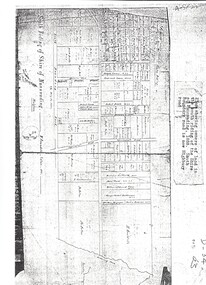
Map, Shire of Nunawading 1888
... ...south boundary road...burwood east...Whitehorse Historical Society Inc. 2-10 Deep Creek Road Mitcham melbourne shire of nunawading. south riding south boundary road burwood east highbury road springvale road mahoneys road forest hill holland road blackburn south burwood highway Plan showing owners of land in the South Riding of the Shire of Nunawading, 1888. ...Plan showing owners of land in the South Riding of the Shire of Nunawading, 1888. South Boundary Road is now Highbury Road.shire of nunawading. south riding, south boundary road, burwood east, highbury road, springvale road, mahoneys road, forest hill, holland road, blackburn south, burwood highway -
 Whitehorse Historical Society Inc.
Document, History of Tally Ho Boys Home, 1972
... ...Boundary Road Burwood East...Boundary Road (now Highbury Road). 2 letters (16/7/1972 & 28/5/1972) to Nancy Leach from E. Hinneberg, Assistant Superintendent, Tally Ho, about his association with Tally Ho. Youth Services Tally Ho Boys Home Cole George Rev. Cole Mrs Hoadley Abel Boundary Road Burwood East ...Three papers on History of Boys Training Farm, Highbury Road, Tally Ho3 papers on History of Boys Training Farm, Highbury Road, Tally Ho, commenced in 1903 by Rev. and Mrs George Cole. The story covers the period from 1903-1930. The farm was built on land bought from Abel Hoadley for 1,000 Pounds near the corner of Springvale Road in Boundary Road (now Highbury Road). 2 letters (16/7/1972 & 28/5/1972) to Nancy Leach from E. Hinneberg, Assistant Superintendent, Tally Ho, about his association with Tally Ho.Three papers on History of Boys Training Farm, Highbury Road, Tally Hoyouth services, tally ho boys home, cole, george, rev., cole, mrs, hoadley, abel, boundary road burwood east, highbury road, burwood east, springvale road, burwood east, leach, nancy, hinneberg, ernest. -
 Whitehorse Historical Society Inc.
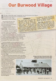
Article - The Bulletin newsletter, The Bulletin Jun - Aug 2022, Our Burwood Village, June 2022
... ...Boundary Road Burwood East...Whitehorse Historical Society Inc. 2-10 Deep Creek Road Mitcham melbourne In The Age, 12 May 1858, was a list of lot sales in the village of Ballyshanassy, now Burwood. It was in the parish of Nunawading at the time. The sale of Crown Land in Ballyshanassy 02/05/1858 Ballyshanassy Albers Ernest Boundary Road Burwood East Dempsey An article about the first settlement surveyed in 1858 in the Burwood area known as Ballyshanassy. ...An article about the first settlement surveyed in 1858 in the Burwood area known as Ballyshanassy. It later became Norwood and finally Burwood in 1879.An article about the first settlement surveyed in 1858 in the Burwood area known as Ballyshanassy. It later became Norwood and finally Burwood in 1879.An article about the first settlement surveyed in 1858 in the Burwood area known as Ballyshanassy. It later became Norwood and finally Burwood in 1879.ballyshanassy, albers ernest, boundary road burwood east, dempsey -
 Melbourne Tram Museum
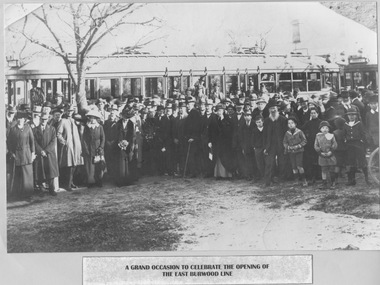
Photograph - Crowd gathered at opening of Burwood line, 10/6/1916
... Burwood...Norwood Road...Toorak Road...Boundary Road...Warrigal Road...East...The location is the new tram Burwood tram terminus in Norwood Road (later Toorak Road) at Boundary Road (later Warrigal Road). The caption's reference to East Burwood is incorrect - an error possibly made by the writer of the caption who glued the photo and caption to the blue paper. ...East Burwood was the name of the line between 1978 and 2005. In 1916 the new Burwood line beyond Camberwell Junction was mostly single track with many passing loops. The service proved to be so popular that the Hawthorn Tramways Trust's 10 maximum traction cars were quickly supplemented by 4 similar trams purchased from the Prahran and Malvern Tramways Trust. Yields information about the opening of the Burwood line maximum traction Burwood Norwood Road Toorak Road Boundary ...Photograph shows a large crowd of formally dressed adults and children standing on open ground in front of a leafless tree and two long (maximum traction) tramcars. The location is the new tram Burwood tram terminus in Norwood Road (later Toorak Road) at Boundary Road (later Warrigal Road). The caption's reference to East Burwood is incorrect - an error possibly made by the writer of the caption who glued the photo and caption to the blue paper. East Burwood was the name of the line between 1978 and 2005. In 1916 the new Burwood line beyond Camberwell Junction was mostly single track with many passing loops. The service proved to be so popular that the Hawthorn Tramways Trust's 10 maximum traction cars were quickly supplemented by 4 similar trams purchased from the Prahran and Malvern Tramways Trust.Yields information about the opening of the Burwood line Black and white photograph glued to blue paper with note below. Note reads: "A grand occasion to celebrate the opening of the East [sic] Burwood line" maximum traction, burwood, norwood road, toorak road, boundary road, warrigal road, east burwood, 1978, camberwell junction, hawthorn tramway trust, prahran and malvern tramway trust -
Whitehorse Historical Society Inc.
Map, City of Nunawading, c. 1960
... Whitehorse Historical Society Inc. 2-10 Deep Creek Road Mitcham melbourne Mitcham Nunawading Blackburn Blackburn North Blackburn South Burwood East Vermont South Forest Hill Vermont Map showing boundaries of the City of Nunawading Scale: 1:36,000 Map showing boundaries of the City of Nunawading Scale: 1:36,000 City of Nunawading Map Map ...Map showing boundaries of the City of Nunawading Scale: 1:36,000Map showing boundaries of the City of Nunawading Scale: 1:36,000Map showing boundaries of the City of Nunawading Scale: 1:36,000mitcham, nunawading, blackburn, blackburn north, blackburn south, burwood east, vermont south, forest hill, vermont -
Whitehorse Historical Society Inc.
Document, Harkaway National School
... Burwood East State School No 454...Thompson...John Edward...Street names...Ballyshanassy Road...Boundary...Whitehorse Historical Society Inc. 2-10 Deep Creek Road Mitcham melbourne Pioneers Harkaway National School Burwood East State School No 454 Thompson John Edward Street names Ballyshanassy Road Boundary Road Delaney's Road Description and history of Harkaway National School, plus changing of many street names and early pioneers. ...Description and history of Harkaway National School, plus changing of many street names and early pioneers.Description and history of Harkaway National School, plus changing of many street names and early pioneers.Description and history of Harkaway National School, plus changing of many street names and early pioneers.pioneers, harkaway national school, burwood east state school no 454, thompson, john edward, street names, ballyshanassy road, boundary road, delaney's road -
Whitehorse Historical Society Inc.
Article, Thousands switch seats; Deakin spills east, 1968
... Whitehorse Historical Society Inc. 2-10 Deep Creek Road Mitcham melbourne The changes also affect Blackburn, East Burwood, Forest Hill, Vermont and Heatherdale. Electoral boundaries ...Photocopy of article about an electoral redistribution which transfers part of Box Hill from Bruce to Deakin.Photocopy of article about an electoral redistribution which transfers part of Box Hill from Bruce to Deakin. The changes also affect Blackburn, East Burwood, Forest Hill, Vermont and Heatherdale.Photocopy of article about an electoral redistribution which transfers part of Box Hill from Bruce to Deakin. electoral boundaries, box hill, blackburn, burwood east, forest hill, vermont, heatherdale, jarman, alan -
Whitehorse Historical Society Inc.
Map, Aerial maps, 2/04/1966 12:00:00 AM
... Whitehorse Historical Society Inc. 2-10 Deep Creek Road Mitcham melbourne aerial photographs blackburn blackburn south forest hill nunawading box hill burwood burwood east donvale mount waverley glen waverley wantirna vermont south mitcham ringwood north ringwood Melbourne 1966 project, runs 10A and 11A, lens 122 151.75 mm 9,800. Photo nos 77, 107, 109, 161, 163, 165. Melbourne 1966 project, runs 10A,11A and 12A, lens 122 151.75 mm 9,800. Photo nos 77, 107, 109, 161, 163, 165. Areas and boundaries ...Melbourne 1966 project, runs 10A and 11A, lens 122 151.75 mm 9,800. Photo nos 77, 107, 109, 161, 163, 165.Melbourne 1966 project, runs 10A,11A and 12A, lens 122 151.75 mm 9,800. Photo nos 77, 107, 109, 161, 163, 165. Areas and boundaries: Map no 77 W. Park and Cook Roads; E. Dubon Rd; N Oban Rd; S Reilly St. Map No 107. W. Indra Rd and Pakenham St; E. Rooks Rd & McLares Rd; N. Maroondah Hwy; S. Hawthorn Rd & Eley Rd. Map No 109 W. Elgar Rd. E. Blackburn Rd & McKean St; S. Eley Rd & Burwood Hwy. Map No 161. W. Elgar Rd & Huntingdale Rd; E. Blackburn Rd; N. Burwood Hwy; S. Waverley Rd. Map No 163. W. Blackburn Rd; S. Springvale Rd; N. Eley Rd & Hawthorn Rd; S. Glen Waverley Railway Line. Map No 165. W. Stanley Rd, Vermont South; E. Cathies Lane, Wantirna South; N. North of Burwood Hwy; S. High Street. Melbourne 1966 project, runs 10A and 11A, lens 122 151.75 mm 9,800. Photo nos 77, 107, 109, 161, 163, 165. aerial photographs, blackburn, blackburn south, forest hill, nunawading, box hill, burwood, burwood east, donvale, mount waverley, glen waverley, wantirna, vermont south, mitcham, ringwood north, ringwood -
Whitehorse Historical Society Inc.
Map, Aerial photographs Nunawading, 1972
... Road Mitcham melbourne Project runs 34 - 39 - City of Nunawading. frames numbered from South to North boundaries, each strip numbered from West to east. The series extends further West to Box Hill and East to Ringwood than the 1970 project. No index map. Sheets 39/2 and 34/28 missing. Victoria. Department of Crown Lands and Survey Aerial photographs Nunawading Mitcham Blackburn Blackburn North Blackburn South Forest Hill Vermont Burwood ...Department of Crown Lands and Survey, Melbourne, 1972.Department of Crown Lands and Survey, Melbourne, 1972. Project runs 34 - 39 - City of Nunawading. frames numbered from South to North boundaries, each strip numbered from West to east. The series extends further West to Box Hill and East to Ringwood than the 1970 project. No index map. Sheets 39/2 and 34/28 missing.non-fictionDepartment of Crown Lands and Survey, Melbourne, 1972.victoria. department of crown lands and survey, aerial photographs, nunawading, mitcham, blackburn, blackburn north, blackburn south, forest hill, vermont, burwood east, box hill, ringwood, vermont south -
Whitehorse Historical Society Inc.
Map, Aerial photographs Nunawading, 1976
... Road Mitcham melbourne Runs 29 - 33 City of Nunawading. Frames numbered from South to North boundaries, each strip numbered from West to East. No index map. Sheets 30/8 and 30/9 missing. Victoria. Department of Crown Lands and Survey Aerial Photographs Nunawading Mitcham Blackburn Blackburn North Blackburn South Forest Hill Vermont Vermont South Burwood East Box Hill Ringwood Department of Crown Lands and Survey, Melbourne, 1976 Project. ...Department of Crown Lands and Survey, Melbourne, 1976 Project.Department of Crown Lands and Survey, Melbourne, 1976 Project. Runs 29 - 33 City of Nunawading. Frames numbered from South to North boundaries, each strip numbered from West to East. No index map. Sheets 30/8 and 30/9 missing.non-fictionDepartment of Crown Lands and Survey, Melbourne, 1976 Project. victoria. department of crown lands and survey, aerial photographs, nunawading, mitcham, blackburn, blackburn north, blackburn south, forest hill, vermont, vermont south, burwood east, box hill, ringwood -
Whitehorse Historical Society Inc.
Map, Aerial Photographs Nunawading, 1970
... Road Mitcham melbourne Project runs 34 - 39 - City of Nunawading. Frames numbered from South to North boundaries, each strip numbered from East to West. See table of index and photo numbers attached. State Aerial Survey Aerial photographs Nunawading Mitcham Blackburn Blackburn North Blackburn South Forest Hill Vermont Burwood East Vermont South State Aerial Survey, Melbourne 1970. ...State Aerial Survey, Melbourne 1970.State Aerial Survey, Melbourne 1970. Project runs 34 - 39 - City of Nunawading. Frames numbered from South to North boundaries, each strip numbered from East to West. See table of index and photo numbers attached.non-fictionState Aerial Survey, Melbourne 1970.state aerial survey, aerial photographs, nunawading, mitcham, blackburn, blackburn north, blackburn south, forest hill, vermont, burwood east, vermont south -
 Whitehorse Historical Society Inc.
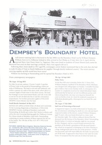
Article, Dempsey's Boundary Hotel, 1873
... An article about Dempsey's Boundary Hotel, NW. cnr Highbury & Middleborough Roads, East Burwood. Licensees Mary Anne & William Dempsey....Road Mitcham melbourne Licensees Mary Anne & William Dempsey. Dempsey William Boundary Hotel Green Mount Dempsey Mary Anne Parish of Nunawading An article about Dempsey's Boundary Hotel, NW. cnr Highbury & Middleborough Roads, East Burwood. ...An article about Dempsey's Boundary Hotel, NW. cnr Highbury & Middleborough Roads, East Burwood.An article about Dempsey's Boundary Hotel, NW. cnr Highbury & Middleborough Roads, East Burwood. Licensees Mary Anne & William Dempsey.An article about Dempsey's Boundary Hotel, NW. cnr Highbury & Middleborough Roads, East Burwood. dempsey william, boundary hotel, green mount, dempsey mary anne, parish of nunawading