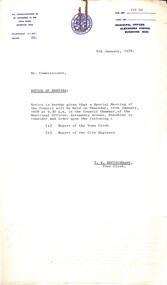
Showing 507 items matching "boundary street"
-
 Port Melbourne Historical & Preservation Society
Plan - Evans Street from ingles Street to Boundary Street, 1893 - 1919
... Evans Street from ingles Street to Boundary Street...Plan of Evans Street from Ingles Street to Boundary Street 1893.....Port Melbourne Historical & Preservation Society Port Melbourne Town Hall 333 Bay Street Port Melbourne melbourne Engineering - Roads Streets Lanes and Footpaths Plan of Evans Street from Ingles Street to Boundary Street 1893.. Plan Evans Street from ingles Street to Boundary Street ...Plan of Evans Street from Ingles Street to Boundary Street 1893..engineering - roads streets lanes and footpaths -
Port Melbourne Historical & Preservation Society
Plan - Boundary Street from Quinn Street to Evans Street, Engineering Department, Town of Port Melbourne, 1893 - 1919
... Boundary Street from Quinn Street to Evans Street...Plan of Boundary Street from Quinn Street to Evans Street 1893....Plan Boundary Street from Quinn Street to Evans Street Engineering Department, Town of Port Melbourne ...Plan of Boundary Street from Quinn Street to Evans Street 1893.engineering - roads streets lanes and footpaths -
Port Melbourne Historical & Preservation Society
Plan - Evans Street from Ingles Street to Boundary Street, Engineering Department, Town of Port Melbourne, 1893 - 1919
... Evans Street from Ingles Street to Boundary Street...Plan of Evans Street from Ingles Street to Boundary Street Loan no 5 1893....Port Melbourne Historical & Preservation Society Port Melbourne Town Hall 333 Bay Street Port Melbourne melbourne engineering - roads streets lanes and footpaths Plan of Evans Street from Ingles Street to Boundary Street Loan no 5 1893. Plan Evans Street from Ingles Street to Boundary Street Engineering Department, Town of Port Melbourne ...Plan of Evans Street from Ingles Street to Boundary Street Loan no 5 1893.engineering - roads streets lanes and footpaths -
 Port Melbourne Historical & Preservation Society
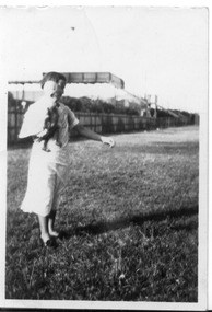
Photograph - Fred Nicholson and his mother, bridge over railway at Boundary Street, Port Melbourne, 1938
... Fred Nicholson and his mother, bridge over railway at Boundary Street, Port Melbourne......boundary street...Photograph Fred Nicholson and his mother, bridge over railway at Boundary Street, Port Melbourne ...Photo showing bridge over railway at Boundary St. Fred Nicholson and his mother, 1938.families, engineering - roads streets lanes and footpaths, fred nicholson, boundary street -
Port Melbourne Historical & Preservation Society
Document - Specification, Metalling and chanelling, Danks Street from Esplanade East to Boundary Street South, Engineering Department, Town of Port Melbourne, 14 Mar 1893
... Specification, Metalling and chanelling, Danks Street from Esplanade East to Boundary Street South...Specification for metalling and channelling Danks Street from Esplanade East to Boundary Street South (Pickles Street) Loan Works 1893 plan 19; relates to plan 98.2...Port Melbourne Historical & Preservation Society Port Melbourne Town Hall 333 Bay Street Port Melbourne melbourne Engineering - Roads Streets Lanes and Footpaths Town Planning Town Clerks Mayors Arthur Victor HEATH James John BARTLETT Signed by JJ Bartlett (Mayor) 14.3.1893 Specification for metalling and channelling Danks Street from Esplanade East to Boundary Street South (Pickles Street) Loan Works 1893 plan 19; relates to plan 98.2 Document Specification, Metalling and chanelling, Danks Street from Esplanade East to Boundary Street South Engineering Department, Town of Port Melbourne ...Specification for metalling and channelling Danks Street from Esplanade East to Boundary Street South (Pickles Street) Loan Works 1893 plan 19; relates to plan 98.2Signed by JJ Bartlett (Mayor) 14.3.1893engineering - roads streets lanes and footpaths, town planning, town clerks, mayors, arthur victor heath, james john bartlett -
Port Melbourne Historical & Preservation Society
Plan - Metalling and channelling Danks Street from Esplanade East to Boundary Street South, Engineering Department, Town of Port Melbourne, 14 Mar 1893
... Metalling and channelling Danks Street from Esplanade East to Boundary Street South...Plan for metalling and channelling Danks Street from Esplanade East to Boundary Street South (Pickles Street) Loan Works 1893 plan 19; relates to specification 98.1...Port Melbourne Historical & Preservation Society Port Melbourne Town Hall 333 Bay Street Port Melbourne melbourne Engineering - Roads Streets Lanes and Footpaths Town Planning Town Clerks Mayors Arthur Victor HEATH James John BARTLETT Signed by JJ Bartlett (Mayor) 14.3.1893 Plan for metalling and channelling Danks Street from Esplanade East to Boundary Street South (Pickles Street) Loan Works 1893 plan 19; relates to specification 98.1 Plan Metalling and channelling Danks Street from Esplanade East to Boundary Street South Engineering Department, Town of Port Melbourne ...Plan for metalling and channelling Danks Street from Esplanade East to Boundary Street South (Pickles Street) Loan Works 1893 plan 19; relates to specification 98.1Signed by JJ Bartlett (Mayor) 14.3.1893engineering - roads streets lanes and footpaths, town planning, town clerks, mayors, arthur victor heath, james john bartlett -
Port Melbourne Historical & Preservation Society
Document - Specification, Tramway, Normanby Road, Ingles Street to Boundary Street, Port Melbourne, 14 Mar 1893
... Specification, Tramway, Normanby Road, Ingles Street to Boundary Street, Port Melbourne...Written specification for works attached to plan of tramway in Normanby Road from Ingles Street to Boundary Street (Reg 66.1), 1893....Bartlett (Mayor) Written specification for works attached to plan of tramway in Normanby Road from Ingles Street to Boundary Street (Reg 66.1), 1893. Document Specification, Tramway, Normanby Road, Ingles Street to Boundary Street, Port Melbourne ...Written specification for works attached to plan of tramway in Normanby Road from Ingles Street to Boundary Street (Reg 66.1), 1893.A.V. Heath (Town Surveyor) J.J. Bartlett (Mayor)engineering - roads streets lanes and footpaths, transport - tramways, town planning, town clerks, mayors, arthur victor heath, james john bartlett -
Port Melbourne Historical & Preservation Society
Plan - Tramway, Normanby Road, Ingles Street to Boundary Street, Port Melbourne, 14 Mar 1893
... Tramway, Normanby Road, Ingles Street to Boundary Street, Port Melbourne...Plan of tramway in Normanby Road from Ingles Street to Boundary Street, together with written specification for works attached (Reg 66.2), 1893....Plan Tramway, Normanby Road, Ingles Street to Boundary Street, Port Melbourne ...Plan of tramway in Normanby Road from Ingles Street to Boundary Street, together with written specification for works attached (Reg 66.2), 1893.A.V. Heath (Town Surveyor) J.J. Bartlett (Mayor)engineering - roads streets lanes and footpaths, transport - tramways, town planning, town clerks, mayors, arthur victor heath, james john bartlett -
Port Melbourne Historical & Preservation Society
Plan - Metalling and channelling Evans Street from Ingles Street to Boundary Street, 14 Mar 1893
... Metalling and channelling Evans Street from Ingles Street to Boundary Street...Specifications (94.1) and Plan (94.2) for metalling and channelling Evans Street from Ingles Street to Boundary Street . Loan Works 1893. Plan number 8....Plan Metalling and channelling Evans Street from Ingles Street to Boundary Street ...Specifications (94.1) and Plan (94.2) for metalling and channelling Evans Street from Ingles Street to Boundary Street . Loan Works 1893. Plan number 8.Both signed by J.J. Bartlett. (Mayor).engineering - roads streets lanes and footpaths, town planning, town clerks, mayors, arthur victor heath, james john bartlett -
Port Melbourne Historical & Preservation Society
Document - Specification, Metalling and chanelling, Boundary Street South, Graham Street to St Vincents Street, Arthur Victor Heath, Town Clerk et al, 14 Mar 1893
... Specification, Metalling and chanelling, Boundary Street South, Graham Street to St Vincents Street...Specifications (Reg. 77.1) and plan (Reg 77.2) for metalling and channelling Boundary Street South [Pickles Street] from Graham Street to St. ...Bartlett (Mayor) Specifications (Reg. 77.1) and plan (Reg 77.2) for metalling and channelling Boundary Street South [Pickles Street] from Graham Street to St. ...Specifications (Reg. 77.1) and plan (Reg 77.2) for metalling and channelling Boundary Street South [Pickles Street] from Graham Street to St. Vincents Street. Loan works 1893, plan No. 5.A.V. Heath (Town Surveyor):J.J. Bartlett (Mayor)engineering - roads streets lanes and footpaths, town planning, town clerks, mayors, arthur victor heath, james john bartlett -
Port Melbourne Historical & Preservation Society
Plan - Metalling and chanelling, Boundary Street South, Graham Street to St Vincents Street, 14 Mar 1893
... Metalling and chanelling, Boundary Street South, Graham Street to St Vincents Street...Specifications (Reg. 77.1) and plan (Reg 77.2) for metalling and channelling Boundary Street South [Pickles Street] from Graham Street to St. ...Plan Metalling and chanelling, Boundary Street South, Graham Street to St Vincents Street ...Specifications (Reg. 77.1) and plan (Reg 77.2) for metalling and channelling Boundary Street South [Pickles Street] from Graham Street to St. Vincents Street. Loan works 1893, plan No. 5.J.J. Bartlett (Mayor) 14/3/93engineering - roads streets lanes and footpaths, town planning, town clerks, mayors, arthur victor heath, james john bartlett -
 Port Melbourne Historical & Preservation Society
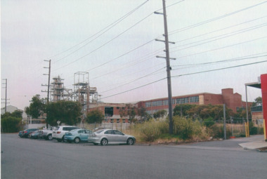
Photograph - J Kitchen & Sons perimeter survey, Boundary Street, Dec 2013
... J Kitchen & Sons perimeter survey, Boundary Street...Series 1 of colour photographs taken by Lionel Layfield as he walked around the perimeter of the J Kitchen & Sons Pty Ltd factory site during the early demolition of most of the buildings. .37-.45 - along Boundary Street past White Street to Normanby Road...Industry - Manufacturing Built Environment - Industrial Business and Traders - Soaps/Candles Demolitions J Kitchen & Sons Pty Ltd Symex Holdings Ltd North Port Oval Port Melbourne Cricket Ground Series 1 of colour photographs taken by Lionel Layfield as he walked around the perimeter of the J Kitchen & Sons Pty Ltd factory site during the early demolition of most of the buildings. .37-.45 - along Boundary Street past White Street to Normanby Road Photograph J Kitchen & Sons perimeter survey, Boundary Street ...As the former j Kitchen & Sons site was being cleared, Lionel Layfield, who had worked at the site for many years undertook several pictorial perimeter surveys. These photos were taken in Dec 2013.Series 1 of colour photographs taken by Lionel Layfield as he walked around the perimeter of the J Kitchen & Sons Pty Ltd factory site during the early demolition of most of the buildings. .37-.45 - along Boundary Street past White Street to Normanby Roadindustry - manufacturing, built environment - industrial, business and traders - soaps/candles, demolitions, j kitchen & sons pty ltd, symex holdings ltd, north port oval, port melbourne cricket ground -
Port Melbourne Historical & Preservation Society
Photograph - Towers, J Kitchen & Sons site, Boundary Street, Port Melbourne, 1960s
... Towers, J Kitchen & Sons site, Boundary Street, Port Melbourne...Two clusters of towers on Boundary St Photograph Towers, J Kitchen & Sons site, Boundary Street, Port Melbourne ...Black and white photo on foam board. Towers at Kitchen's site. Two clusters of towers on Boundary Stindustry, manufacturing, j kitchen & sons pty ltd, pental products pty ltd, symex holdings ltd, boundary road -
Port Melbourne Historical & Preservation Society
Photograph - Bay and Boundary Hotel, Bay Street, Port Melbourne, Ron Laing, 1990s
... Bay and Boundary Hotel, Bay Street, Port Melbourne... Hotel From a group of Ron Laing photographs of Port Melbourne hotels, 1990s: the Bay & Boundary (originally the Rising Sun) Photograph Bay and Boundary Hotel, Bay Street, Port Melbourne Ron Laing ...Part of Ron Laing's collection of photographs recording Port Melbourne over a thirteen year period. Donated to the PMH&PS by the photographer.From a group of Ron Laing photographs of Port Melbourne hotels, 1990s: the Bay & Boundary (originally the Rising Sun)business and traders - hotels, ron laing, bay and boundary hotel -
 Sunshine and District Historical Society Incorporated
Map - Shire of Melton Map 1982
... Map of Melton showing boundaries and streets...Shire of Melton Map Shire of Melton Map 1982 Map of Melton showing boundaries and streets Map Shire of Melton Map 1982 ...Shire of Melton Map 1982shire of melton, map -
 Uniting Church Archives - Synod of Victoria
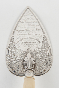
Ceremonial object - Commemorative Trowel
... Presented to John Thompson Esq on the occasion of laying a Memorial Stone of Boundary Street Congregational Mission Church Southport. 23rd May 1890....Uniting Church Archives - Synod of Victoria 54 Serrell Street Malvern East melbourne congregational mission church southport Presented to John Thompson Esq on the occasion of laying a Memorial Stone of Boundary Street Congregational Mission Church Southport. 23rd May 1890. ...Decorated silver trowel with bone handle.Presented to John Thompson Esq on the occasion of laying a Memorial Stone of Boundary Street Congregational Mission Church Southport. 23rd May 1890.congregational mission church southport -
 Sunshine and District Historical Society Incorporated
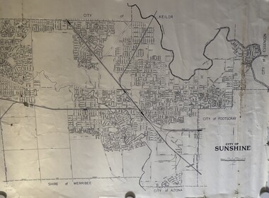
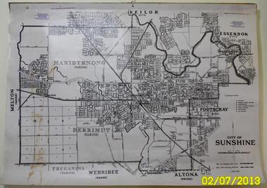
Map - City of Sunshine Map
... Map showing the City of Sunshine boundary and streets...City of Sunshine Map City of Sunshine Map Map showing the City of Sunshine boundary and streets Map City of Sunshine Map ...City of Sunshine Mapcity of sunshine, map -
 Greensborough Historical Society
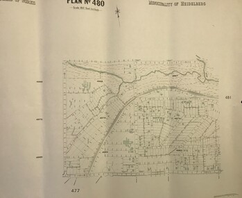
Map, Municipality of Heidelberg Plan No. 480, 17/10/1948
... Map shows streets, buildings, river and major drainage easements in area covered by West boundary Sellars Street, North boundary Yando Street & South boundary Grimshaw Street. ...Greensborough Historical Society 34A Glenauburn Road Lower Plenty Lower Plenty melbourne Map shows streets, buildings, river and major drainage easements in area covered by West boundary Sellars Street, North boundary Yando Street & South boundary Grimshaw Street. ...Map shows streets, buildings, river and major drainage easements in area covered by West boundary Sellars Street, North boundary Yando Street & South boundary Grimshaw Street. Adjoins Map No. 481 to East. Black & white map, features marked in green, gradients in red. Scale: 160 feet to 1 inchgreensborough -
 Sunshine and District Historical Society Incorporated
Map - CITY OF SUNSHINE MAP June 1967, 1967
... The June 1967 map is of the previous CITY OF SUNSHINE showing City and Parish boundaries, streets, railways, creeks, river etc....The June 1967 map is of the previous CITY OF SUNSHINE showing City and Parish boundaries, streets, railways, creeks, river etc. ...The City of Sunshine no longer exists. Part of the eastern area has been annexed by the City of Maribyrnong, and the rest of the old City of Sunshine has been amalgamated with the City of Keilor to form the larger City of Brimbank.This 1967 map is a historical record of the City of Sunshine as it existed 27 years before the amalgamation of Councils, and the creation of the City of Brimbank in 1994.Whitish paper map with black printing that is laminated in clear plastic film, and has a wood slat attached to the top edge. The June 1967 map is of the previous CITY OF SUNSHINE showing City and Parish boundaries, streets, railways, creeks, river etc.Purple ink stamps at top left hand and right hand areas showing address and contact details of 'Sunshine Industrial Promotion Centre.'city of sunshine, june 1967, map, city, parish, boundaries, brimbank -
 Glen Eira Historical Society
Letter - Eastleigh Community Church, East Boundary Road, 216
... Street... McKinnon... Eastleigh Community Church... Bentleigh East... Eastleigh Gospel Chapel... Walsh Brian... Coates Lindsay... McKinnon Gospel Hall... East Boundary...Pearson Bob Deakin Street McKinnon Eastleigh Community Church Bentleigh East Eastleigh Gospel Chapel Walsh Brian Coates Lindsay McKinnon Gospel Hall East Boundary Road Bent Street Letter Eastleigh Community Church, East Boundary Road, 216 ...Two items about this Church: 1/ Printed Email from Brian Walsh, giving brief details of his time at Eastleigh Community Church and McKinnon Gospel Hall dated 21/04/2010 and Reply dated 03/06/2012. 2/ 3 digital photos taken on 20/02/2010 by Claire Barton for GEHS project: 2 different views of the street frontage for the Church and 1 view of the sign on the front wall.pearson bob, deakin street, mckinnon, eastleigh community church, bentleigh east, eastleigh gospel chapel, walsh brian, coates lindsay, mckinnon gospel hall, east boundary road, bent street -
Port Melbourne Historical & Preservation Society
Document - 2003 Calendar, Pat Grainger, Historic Port Melbourne, Oct 2002
... street...faram brothers hardware...ted keogh...marlene keogh...boundary...Production volume: .600 copies transport - railways industry - food religion - anglican (holy trinity) education - primary schools piers and wharves - railway pier education - kindergartens flood religion - melbourne city mission jubilee hall port melbourne yacht club pmyc cruikshank street faram brothers hardware ted keogh marlene keogh boundary rovers swallow street missions to seamen national primary school st josephs catholic primary school Nott Street State School Historic Port Melbourne calendar 2003: ''School Days" Nott Street class on cover, sepia on ivory All following years calendars also recorded against cat no 1864 Historic Port Melbourne Document 2003 Calendar Pat Grainger Port Melbourne Historical and Preservation Society (PMHPS) Econoprint ...Researched, written and designed by member Pat Grainger as a fundraiser for PMH&PS. Production volume: .600 copiesHistoric Port Melbourne calendar 2003: ''School Days" Nott Street class on cover, sepia on ivory All following years calendars also recorded against cat no 1864transport - railways, industry - food, religion - anglican (holy trinity), education - primary schools, piers and wharves - railway pier, education - kindergartens, flood, religion - melbourne city mission, jubilee hall, port melbourne yacht club, pmyc, cruikshank street, faram brothers hardware, ted keogh, marlene keogh, boundary rovers, swallow street, missions to seamen, national primary school, st josephs catholic primary school, nott street state school -
 City of Moorabbin Historical Society (Operating the Box Cottage Museum)
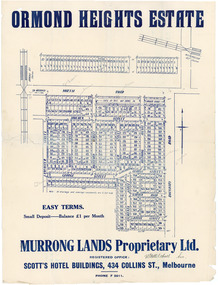
Flyer - Ormond Heights, East Bentleigh
... Street)...Boundary Road (now East Boundary Road)...Example of the progress of the Municipality of Moorabbin North Road Moulden Street George Street Garden Road Bruce Street (now Bethwyn Street) Boundary Road (now East Boundary Road) Murrong Avenue Bay View Street Rochford Street Mitchell Street Lancaster Street East Bentleigh Real Estate Advertising flyer for auction of real estate sales - plan of building blocks for sale Flyer Ormond Heights, East Bentleigh ...The train line from the city to Frankston was electrified which intensified the sale in the municipality of Moorabbin, particularly land which was in the vicinity of the railway stations.Example of the progress of the Municipality of MoorabbinAdvertising flyer for auction of real estate sales - plan of building blocks for salenorth road, moulden street, george street, garden road, bruce street (now bethwyn street), boundary road (now east boundary road), murrong avenue, bay view street, rochford street, mitchell street, lancaster street, east bentleigh, real estate -
 Sunshine and District Historical Society Incorporated
Administrative record - City of Sunshine - Commissioner Mr Alexander Alex George Gillon Collection 1976 - 1982 - Notice of Special meeting of the council 12th January 1978, City of Sunshine, 6th January 1978
... Street...Sunshine West...Hampshire Road...Fairnbairn Road...Boundary...Approval of tender for Tennis Courts Dempster Park including Albion Tennis Club contributions Land Use Permit Display village and subsequent cluster subdivision Station Road Land Use Permit Subdivision and detached house Robinsons Road Land Use Permit Sales and servicing of motorcycles 60A Monash Street Land Use Permit Two display homes and associated car parking Aycliff Drive and Phyllis Parade Land Use Permit Extension to existing primary school Lot 55 Churchill Avenue Land Use Permit Ornamental garden display and sales of domestic pets 553A and 553B Geelong Road Land Use Permit 5 Display homes Camelot Drive and Trafalgar Street Land Use Permit Soccer ground and sports club Selwyn Club Selwyn Street Land Use Permit Subdivision and detached houses Lot 1009 Tamar Drive Enforcement 34 Garnet Street panel beating and spray painting Land Use Permit Factory light engineering lot 45 Cromer Avenue Land Use Permit Poultry farming and dressed chicken sales and take away food premises 159 - 161 Rosamond Road Land Use Permit Flats Lot 9 Mernda Street Land Use Permit Extension to furniture sales buildings 85 - 91 Hampshire Road Land Use Permit Storage of soil and retail plant nursery Northwest corner Fairbairn Road and Boundary Road Land Use Permit Squash court Centre Rosamond Road Enforcement 2 Gregory Street bee keeping Land Use Permit Sand blasting and protective coasting Fairbairn Road Land Use Permit Flats Main Road West, Kodre Street and Washington Street Land Use Permit Store Lot 24 Cromer Avenue Land Use Permit Squash Court Complex lots 32. 33 & 34 Raleigh Road Land Use Permit Panel beating factory McIntyre Road Strata Subdivision 3 Bardsley Street Consolidation of Title 99 Couch Street Amenities Vans Tenders for installation of wheel wash at new tip Land Use Permit Flats Station Road...City of Sunshine Alexander "Alex" George Gillon Sunshine North Tennis Club Albion Tennis Club Dempster Park Phoenix Street Sunshine North Station Road Deer Park Robinsons Road Monash Street Sunshine Aycliff Drive Phyllis Parade Churchill Avenue Braybrook Christ The King Primary School Geelong Road Brooklyn Camelot Drive Trafalgar Street Albanvale Albion Rovers Soccer Club Selwyn Sports Club Selwyn Park Selwyn Street Albion Tamar Drive Garnet Street Cromer Avenue Rosamond Road Maribyrnong Mernda Street Sunshine West Hampshire Road Fairnbairn Road Boundary Road Gregory Street Main Road West Raleigh Road McIntyre Road Approval of tender for Tennis Courts Dempster Park including Albion Tennis Club contributions Land Use Permit Display village and subsequent cluster subdivision Station Road Land Use Permit Subdivision and detached house Robinsons Road Land Use Permit Sales and servicing of motorcycles 60A Monash Street Land Use Permit Two display homes and associated car parking Aycliff Drive and Phyllis Parade Land Use Permit Extension to existing primary school Lot 55 Churchill Avenue Land Use Permit Ornamental garden display and sales of domestic pets 553A and 553B Geelong Road Land Use Permit 5 Display homes Camelot Drive and Trafalgar Street Land Use Permit Soccer ground and sports club Selwyn Club Selwyn Street Land Use Permit Subdivision and detached houses Lot 1009 Tamar Drive Enforcement 34 Garnet Street panel beating and spray painting Land Use Permit Factory light engineering lot 45 Cromer Avenue Land Use Permit Poultry farming and dressed chicken sales and take away food premises 159 - 161 Rosamond Road Land Use Permit Flats Lot 9 Mernda Street Land Use Permit Extension to furniture sales buildings 85 - 91 Hampshire Road Land Use Permit Storage of soil and retail plant nursery Northwest corner Fairbairn Road and Boundary Road Land Use Permit Squash court Centre Rosamond Road Enforcement 2 Gregory Street bee keeping Land Use Permit Sand blasting and protective coasting Fairbairn Road Land Use Permit Flats Main Road West, Kodre Street and Washington Street Land Use Permit Store Lot 24 Cromer Avenue Land Use Permit Squash Court Complex lots 32. 33 & 34 Raleigh Road Land Use Permit Panel beating factory McIntyre Road Strata Subdivision 3 Bardsley Street Consolidation of Title 99 Couch Street Amenities Vans Tenders for installation of wheel wash at new tip Land Use Permit Flats Station Road Foolscap sized document. ...Approval of tender for Tennis Courts Dempster Park including Albion Tennis Club contributions Land Use Permit Display village and subsequent cluster subdivision Station Road Land Use Permit Subdivision and detached house Robinsons Road Land Use Permit Sales and servicing of motorcycles 60A Monash Street Land Use Permit Two display homes and associated car parking Aycliff Drive and Phyllis Parade Land Use Permit Extension to existing primary school Lot 55 Churchill Avenue Land Use Permit Ornamental garden display and sales of domestic pets 553A and 553B Geelong Road Land Use Permit 5 Display homes Camelot Drive and Trafalgar Street Land Use Permit Soccer ground and sports club Selwyn Club Selwyn Street Land Use Permit Subdivision and detached houses Lot 1009 Tamar Drive Enforcement 34 Garnet Street panel beating and spray painting Land Use Permit Factory light engineering lot 45 Cromer Avenue Land Use Permit Poultry farming and dressed chicken sales and take away food premises 159 - 161 Rosamond Road Land Use Permit Flats Lot 9 Mernda Street Land Use Permit Extension to furniture sales buildings 85 - 91 Hampshire Road Land Use Permit Storage of soil and retail plant nursery Northwest corner Fairbairn Road and Boundary Road Land Use Permit Squash court Centre Rosamond Road Enforcement 2 Gregory Street bee keeping Land Use Permit Sand blasting and protective coasting Fairbairn Road Land Use Permit Flats Main Road West, Kodre Street and Washington Street Land Use Permit Store Lot 24 Cromer Avenue Land Use Permit Squash Court Complex lots 32. 33 & 34 Raleigh Road Land Use Permit Panel beating factory McIntyre Road Strata Subdivision 3 Bardsley Street Consolidation of Title 99 Couch Street Amenities Vans Tenders for installation of wheel wash at new tip Land Use Permit Flats Station Road city of sunshine, alexander "alex" george gillon, sunshine north tennis club, albion tennis club, dempster park, phoenix street, sunshine north, station road, deer park, robinsons road, monash street, sunshine, aycliff drive, phyllis parade, churchill avenue, braybrook, christ the king primary school, geelong road, brooklyn, camelot drive, trafalgar street, albanvale, albion rovers soccer club, selwyn sports club, selwyn park, selwyn street, albion, tamar drive, garnet street, cromer avenue, rosamond road, maribyrnong, mernda street, sunshine west, hampshire road, fairnbairn road, boundary road, gregory street, main road west, raleigh road, mcintyre road -
 Sunshine and District Historical Society Incorporated
Administrative record - City of Sunshine - Commissioner Mr Alexander Alex George Gillon Collection 1976 - 1982 - Minutes of the special meeting of council held on 12th January 1978, City of Sunshine, 12th January 1978
... Street...Sunshine West...Hampshire Road...Fairnbairn Road...Boundary...Approval of tender for Tennis Courts Dempster Park including Albion Tennis Club contributions Land Use Permit Display village and subsequent cluster subdivision Station Road Land Use Permit Subdivision and detached house Robinsons Road Land Use Permit Sales and servicing of motorcycles 60A Monash Street Land Use Permit Two display homes and associated car parking Aycliff Drive and Phyllis Parade Land Use Permit Extension to existing primary school Lot 55 Churchill Avenue Land Use Permit Ornamental garden display and sales of domestic pets 553A and 553B Geelong Road Land Use Permit 5 Display homes Camelot Drive and Trafalgar Street Land Use Permit Soccer ground and sports club Selwyn Club Selwyn Street Land Use Permit Subdivision and detached houses Lot 1009 Tamar Drive Enforcement 34 Garnet Street panel beating and spray painting Land Use Permit Factory light engineering lot 45 Cromer Avenue Land Use Permit Poultry farming and dressed chicken sales and take away food premises 159 - 161 Rosamond Road Land Use Permit Flats Lot 9 Mernda Street Land Use Permit Extension to furniture sales buildings 85 - 91 Hampshire Road Land Use Permit Storage of soil and retail plant nursery Northwest corner Fairbairn Road and Boundary Road Land Use Permit Squash court Centre Rosamond Road Enforcement 2 Gregory Street bee keeping Land Use Permit Sand blasting and protective coasting Fairbairn Road Land Use Permit Flats Main Road West, Kodre Street and Washington Street Land Use Permit Store Lot 24 Cromer Avenue Land Use Permit Squash Court Complex lots 32. 33 & 34 Raleigh Road Land Use Permit Panel beating factory McIntyre Road Strata Subdivision 3 Bardsley Street Consolidation of Title 99 Couch Street Amenities Vans Tenders for installation of wheel wash at new tip Land Use Permit Flats Station Road...City of Sunshine Alexander "Alex" George Gillon Sunshine North Tennis Club Albion Tennis Club Dempster Park Phoenix Street Sunshine North Station Road Deer Park Robinsons Road Monash Street Sunshine Aycliff Drive Phyllis Parade Churchill Avenue Braybrook Christ The King Primary School Geelong Road Brooklyn Camelot Drive Trafalgar Street Albanvale Albion Rovers Soccer Club Selwyn Sports Club Selwyn Park Selwyn Street Albion Tamar Drive Garnet Street Cromer Avenue Rosamond Road Maribyrnong Mernda Street Sunshine West Hampshire Road Fairnbairn Road Boundary Road Gregory Street Main Road West Raleigh Road McIntyre Road Approval of tender for Tennis Courts Dempster Park including Albion Tennis Club contributions Land Use Permit Display village and subsequent cluster subdivision Station Road Land Use Permit Subdivision and detached house Robinsons Road Land Use Permit Sales and servicing of motorcycles 60A Monash Street Land Use Permit Two display homes and associated car parking Aycliff Drive and Phyllis Parade Land Use Permit Extension to existing primary school Lot 55 Churchill Avenue Land Use Permit Ornamental garden display and sales of domestic pets 553A and 553B Geelong Road Land Use Permit 5 Display homes Camelot Drive and Trafalgar Street Land Use Permit Soccer ground and sports club Selwyn Club Selwyn Street Land Use Permit Subdivision and detached houses Lot 1009 Tamar Drive Enforcement 34 Garnet Street panel beating and spray painting Land Use Permit Factory light engineering lot 45 Cromer Avenue Land Use Permit Poultry farming and dressed chicken sales and take away food premises 159 - 161 Rosamond Road Land Use Permit Flats Lot 9 Mernda Street Land Use Permit Extension to furniture sales buildings 85 - 91 Hampshire Road Land Use Permit Storage of soil and retail plant nursery Northwest corner Fairbairn Road and Boundary Road Land Use Permit Squash court Centre Rosamond Road Enforcement 2 Gregory Street bee keeping Land Use Permit Sand blasting and protective coasting Fairbairn Road Land Use Permit Flats Main Road West, Kodre Street and Washington Street Land Use Permit Store Lot 24 Cromer Avenue Land Use Permit Squash Court Complex lots 32. 33 & 34 Raleigh Road Land Use Permit Panel beating factory McIntyre Road Strata Subdivision 3 Bardsley Street Consolidation of Title 99 Couch Street Amenities Vans Tenders for installation of wheel wash at new tip Land Use Permit Flats Station Road Foolscap sized document. ...Approval of tender for Tennis Courts Dempster Park including Albion Tennis Club contributions Land Use Permit Display village and subsequent cluster subdivision Station Road Land Use Permit Subdivision and detached house Robinsons Road Land Use Permit Sales and servicing of motorcycles 60A Monash Street Land Use Permit Two display homes and associated car parking Aycliff Drive and Phyllis Parade Land Use Permit Extension to existing primary school Lot 55 Churchill Avenue Land Use Permit Ornamental garden display and sales of domestic pets 553A and 553B Geelong Road Land Use Permit 5 Display homes Camelot Drive and Trafalgar Street Land Use Permit Soccer ground and sports club Selwyn Club Selwyn Street Land Use Permit Subdivision and detached houses Lot 1009 Tamar Drive Enforcement 34 Garnet Street panel beating and spray painting Land Use Permit Factory light engineering lot 45 Cromer Avenue Land Use Permit Poultry farming and dressed chicken sales and take away food premises 159 - 161 Rosamond Road Land Use Permit Flats Lot 9 Mernda Street Land Use Permit Extension to furniture sales buildings 85 - 91 Hampshire Road Land Use Permit Storage of soil and retail plant nursery Northwest corner Fairbairn Road and Boundary Road Land Use Permit Squash court Centre Rosamond Road Enforcement 2 Gregory Street bee keeping Land Use Permit Sand blasting and protective coasting Fairbairn Road Land Use Permit Flats Main Road West, Kodre Street and Washington Street Land Use Permit Store Lot 24 Cromer Avenue Land Use Permit Squash Court Complex lots 32. 33 & 34 Raleigh Road Land Use Permit Panel beating factory McIntyre Road Strata Subdivision 3 Bardsley Street Consolidation of Title 99 Couch Street Amenities Vans Tenders for installation of wheel wash at new tip Land Use Permit Flats Station Road city of sunshine, alexander "alex" george gillon, sunshine north tennis club, albion tennis club, dempster park, phoenix street, sunshine north, station road, deer park, robinsons road, monash street, sunshine, aycliff drive, phyllis parade, churchill avenue, braybrook, christ the king primary school, geelong road, brooklyn, camelot drive, trafalgar street, albanvale, albion rovers soccer club, selwyn sports club, selwyn park, selwyn street, albion, tamar drive, garnet street, cromer avenue, rosamond road, maribyrnong, mernda street, sunshine west, hampshire road, fairnbairn road, boundary road, gregory street, main road west, raleigh road, mcintyre road -
 Bendigo Historical Society Inc.
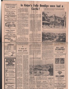
Document - BASIL MILLER COLLECTION: TRAMS AND KNIPE'S CASTLE/FOLLY'
... Walleston, located in Boundary Street, (now known as Valentine Street)....Walleston, located in Boundary Street, (now known as Valentine Street). ...Newspaper clipping, Bendigo Advertiser, Saturday April 15, 1972.'In Knipe's Folly Bendigo once had a castle', by Toora, (alias Amy Huxtable). John Hanlon Knipe bought land from W. E. Walleston, located in Boundary Street, (now known as Valentine Street).person, individual, basil miller -
 Bendigo Historical Society Inc.
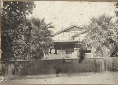
Photograph - T C WATTS & SON COLLECTION: BENDIGO HOUSE, 1927
... In the mid to late 1930's they moved to Boundary Street....In the mid to late 1930's they moved to Boundary Street. PLACE Building residential Stamped on back in rectangle ''T.C. ...Brydon Stewart Melrose (1895-1989) was a dentist. He married Florence Emily Reville in 1921. Their home in Myrtle Street was called Morayfield. In the mid to late 1930's they moved to Boundary Street.Black and white photograph mounted on rectangular grey board. House, weatherboard, cement sheet and timber under eaves. Double door entrance. Rough cast cement verandah with timber posts. Two palms in front. Timber top rail to closely slatted wooden fence, chimney pots visible. On back of photo:" Bryden Melrose, £850, Date stamp 9 December 1927. refer S & U, D.T. Coy first'Frank A. Jeffree Bendigoplace, building, residential, stamped on back in rectangle ''t.c. watts and son/auctioneer/estate agents/253 mitchell street/bendigo'' stamped on back in circle ''royal historical society of victoria, bendigo branch'' -
 Greensborough Historical Society
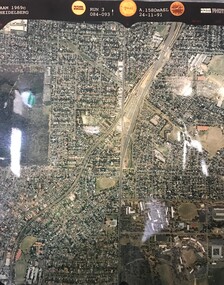
Aerial Photograph, AAM Photographics, Heidelberg AAM1969c 084, 24/11/1991
... One of an overlapping series of aerial photographs of the Heidelberg/Greensborough areas, covering Greensborough, Macleod, Viewbank & Yallambie. North boundary Nell Street, South boundary Simpson Barracks...Greensborough Historical Society 34A Glenauburn Road Lower Plenty Lower Plenty melbourne One of an overlapping series of aerial photographs of the Heidelberg/Greensborough areas, covering Greensborough, Macleod, Viewbank & Yallambie. North boundary Nell Street, South boundary Simpson Barracks greensborough viewbank yallambie Laminated colour aerial photograph Heidelberg AAM1969c 084 Aerial Photograph AAM Photographics ...One of an overlapping series of aerial photographs of the Heidelberg/Greensborough areas, covering Greensborough, Macleod, Viewbank & Yallambie. North boundary Nell Street, South boundary Simpson BarracksLaminated colour aerial photographgreensborough, viewbank, yallambie -
 Bendigo Historical Society Inc.
Newspaper - NEWSPAPER CLIPPINGS EARLY PHOTOGRAPHS OF BENDIGO STREETSCAPE, Unknown
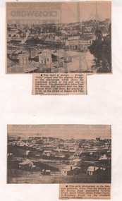
... Image shows Knipe's Castle in Boundary Street ''on the Ironbark Ranges'' top right....Image shows Knipe's Castle in Boundary Street ''on the Ironbark Ranges'' top right. ...Two Black & White Early Photographs of Bendigo. (Photograph 1) Panorama is taken from the Masonic Hall location with the Rifle Brigade Hotel on the corner of Rowan and View Streets and Knipe's Folly in top right of image. (Photograph 2) An early photograph of the Bendigo Goldfields the suburb of Ironbark taken from the vicinity of Mt. Korong Road, overlooking Victoria Street and Quick Street. Image shows Knipe's Castle in Boundary Street ''on the Ironbark Ranges'' top right.bendigo, streetscape, rowan & view st, mt korong rd -
 Greensborough Historical Society
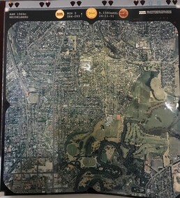
Aerial Photograph, AAM Photographics, Heidelberg AAM1969c 106, 24/11/1991
... One of an overlapping series of aerial photographs of the Heidelberg/Greensborough areas in 1991, covering the Simpson Barracks, Greensborough & Viewbank. North boundary Nell Street, East boundary Plenty River, South boundary Lower Plenty Road....Greensborough Historical Society 34A Glenauburn Road Lower Plenty Lower Plenty melbourne One of an overlapping series of aerial photographs of the Heidelberg/Greensborough areas in 1991, covering the Simpson Barracks, Greensborough & Viewbank. North boundary Nell Street, East boundary Plenty River, South boundary Lower Plenty Road. simpson barracks greensborough viewbank Laminated colour aerial photograph Heidelberg AAM1969c 106 Aerial Photograph AAM Photographics ...One of an overlapping series of aerial photographs of the Heidelberg/Greensborough areas in 1991, covering the Simpson Barracks, Greensborough & Viewbank. North boundary Nell Street, East boundary Plenty River, South boundary Lower Plenty Road.Laminated colour aerial photographsimpson barracks, greensborough, viewbank