Showing 42 items matching "braeside"
-
 Camberwell Historical Society
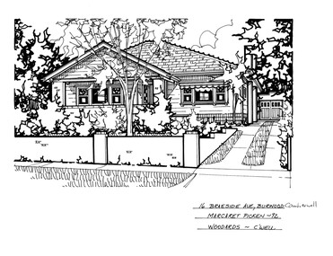
Drawing (series) - Architectural drawing, 16 Braeside Avenue, Burwood, 2002
... 16 Braeside Avenue, Burwood...Pen and ink architectural drawing on drafting film of 16 Braeside Avenue, Burwood by Margaret Picken...16 BRAESIDE AVE., BURWOOD CAMBERWELL / MARGARET PICKEN - 92 / WOODARDS - C'WELL...The fact that each drawing is dated with the year it was created also proves a valuable record for house historians - since that date a number of the depicted properties have either been altered or demolished. artist architectural drawings margaret picken camberwell houses 16 BRAESIDE AVE., BURWOOD CAMBERWELL / MARGARET PICKEN - 92 / WOODARDS - C'WELL Pen and ink architectural drawing on drafting film of 16 Braeside Avenue, Burwood by Margaret Picken 16 Braeside Avenue, Burwood Drawing Architectural drawing ...artist, architectural drawings, margaret picken, camberwell, housesartist, architectural drawings, margaret picken, camberwell, houses -
 Camberwell Historical Society
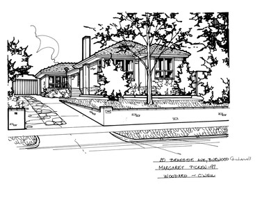
Drawing (series) - Architectural drawing, 20 Braeside Avenue, Burwood, 2002
... 20 Braeside Avenue, Burwood...Pen and ink architectural drawing on drafting film of 20 Braeside Avenue, Burwood by Margaret Picken...20 BRAESIDE AVE., BURWOOD CAMBERWELL / MARGARET PICKEN - 97 / WOODARD - C'WELL...The fact that each drawing is dated with the year it was created also proves a valuable record for house historians - since that date a number of the depicted properties have either been altered or demolished. artist architectural drawings margaret picken camberwell houses 20 BRAESIDE AVE., BURWOOD CAMBERWELL / MARGARET PICKEN - 97 / WOODARD - C'WELL Pen and ink architectural drawing on drafting film of 20 Braeside Avenue, Burwood by Margaret Picken 20 Braeside Avenue, Burwood Drawing Architectural drawing ...artist, architectural drawings, margaret picken, camberwell, housesartist, architectural drawings, margaret picken, camberwell, houses -
 Ringwood and District Historical Society
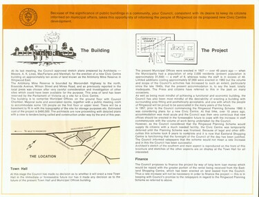
Photograph, City of Ringwood Council document (June 1968) highlighting new Civic Centre build in Braeside Avenue, Ringwood
... City of Ringwood Council document (June 1968) highlighting new Civic Centre build in Braeside Avenue, Ringwood...City of Ringwood Council document (June 1968) highlighting new Civic Centre build in Braeside Avenue, Ringwood...Ringwood and District Historical Society 125A Warrandyte Road Ringwood North melbourne City of Ringwood Council document (June 1968) highlighting new Civic Centre build in Braeside Avenue, Ringwood City of Ringwood Council document (June 1968) highlighting new Civic Centre build in Braeside Avenue, Ringwood Photograph ...City of Ringwood Council document (June 1968) highlighting new Civic Centre build in Braeside Avenue, Ringwood -
 Ringwood and District Historical Society
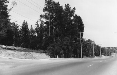
Photograph, Maroondah Highway East, Ringwood- 1969. Looking west towards Ringwood from Braeside Ave corner
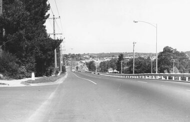
... Looking west towards Ringwood from Braeside Ave corner....Written on back of photograph: "Nov 1969, cnr of Braeside Ave and Maroondah Highway."...Looking west towards Ringwood from Braeside Ave corner. Photograph ...Black and white photographWritten on back of photograph: "Nov 1969, cnr of Braeside Ave and Maroondah Highway." -
 Ringwood and District Historical Society
Photograph, Maroondah Highway East, Ringwood- 1973. Westward view from Braeside Avenue along Maroondah Highway
... Westward view from Braeside Avenue along Maroondah Highway....Written on rear of backing sheet: "Ringwood from Braeside Av. 9/73"....Westward view from Braeside Avenue along Maroondah Highway. Photograph ...Black and white photographWritten on rear of backing sheet: "Ringwood from Braeside Av. 9/73". -
 Ringwood and District Historical Society
Photograph, View from Maroondah Highway opposite Braeside Avenue towards Loughnan's Hill - 1973
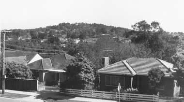
... View from Maroondah Highway opposite Braeside Avenue towards Loughnan's Hill - 1973....View from Maroondah Highway opposite Braeside Avenue towards Loughnan's Hill - 1973....View from Maroondah Highway opposite Braeside Avenue towards Loughnan's Hill - 1973. ...View from Maroondah Highway opposite Braeside Avenue towards Loughnan's Hill - 1973. -
 Ringwood and District Historical Society
Photograph, Aerial view showing East Ringwood oval, Mount Dandenong Road, and Civic Centre, Braeside Avenue/Maroondah Hwy, c.1970
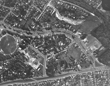
... Aerial view showing East Ringwood oval, Mount Dandenong Road, and Civic Centre, Braeside Avenue/Maroondah Hwy, c.1970....Aerial view showing East Ringwood oval, Mount Dandenong Road, and Civic Centre, Braeside Avenue/Maroondah Hwy, c.1970....Ringwood and District Historical Society 125A Warrandyte Road Ringwood North melbourne Aerial view showing East Ringwood oval, Mount Dandenong Road, and Civic Centre, Braeside Avenue/Maroondah Hwy, c.1970. Aerial view showing East Ringwood oval, Mount Dandenong Road, and Civic Centre, Braeside Avenue/Maroondah Hwy, c.1970. ...Aerial view showing East Ringwood oval, Mount Dandenong Road, and Civic Centre, Braeside Avenue/Maroondah Hwy, c.1970. -
 Stawell Historical Society Inc
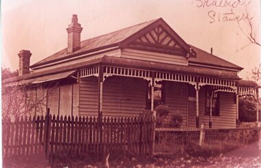
Photograph, "Braeside" Heal Family home in Moonlight Street site now No 45
... "Braeside" Heal Family home in Moonlight Street site now No 45...Home of Heal Family in Moonlight Street site now No 45. Home named Braeside. ...Stawell Historical Society Inc 46 Longfield St Stawell grampians Home of Heal Family in Moonlight Street site now No 45. Home named Braeside. Stawell "Braeside" Heal Family home in Moonlight Street site now No 45 Photograph ...Home of Heal Family in Moonlight Street site now No 45. Home named Braeside. stawell -
 Ringwood and District Historical Society
Photograph, Guest's Bakehouse, Mt. Dandenong Rd. Corner Braeside Ave. 1964". Catalogue card states demolished 1972
... Dandenong Rd. Corner Braeside Ave. 1964". Catalogue card states demolished 1972....Dandenong Rd. Corner Braeside Ave. 1964". Catalogue card states demolished 1972....Dandenong Rd. Corner Braeside Ave. 1964". Catalogue card states demolished 1972. ...Typed below photograph, "Guest's Bakehouse, Mt. Dandenong Rd. Corner Braeside Ave. 1964". Catalogue card states demolished 1972. -
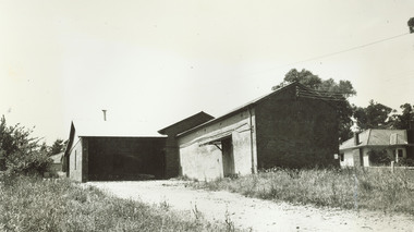
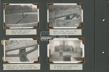
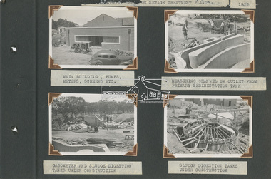 Eltham District Historical Society Inc
Album - Photograph Album, Alan Gardiner, M.M.B.W Braeside Sewage Treatment Plant Construction, 1939
... M.M.B.W Braeside Sewage Treatment Plant Construction...It is known as “Braeside Park” now. [Source: Sewerage Treatment Plant at Braeside, Kingston Local History, https://localhistory.kingston.vic.gov.au/articles/407]...The Sewerage Effluent Treatment Plant at Braeside served the communities of south-east Melbourne for thirty five years until 1975. ...In April 1928 the MMBW had the land and the plans for what they were to construct but the timing of the actual building did not proceed as planned. Before the construction could commence the Great Depression of the 1930s intervened forcing the shelving of its plans. The new owners then offered the land for lease resulting in Frederick Werrett taking the opportunity to take up the land he formerly owned to continue his market gardening activities of growing potatoes, onions and other crops. The land and improvements made by Syme were leased in 1929 to Harry Telford a trainer from New South Wales. Phar Lap grazed there for a short time. [9] However the population of Melbourne continued to grow and the need for a sewerage treatment plant did not go away. In 1939 when the effects of the Depression had dissipated work on the Sewerage Effluent Treatment Plant commenced and the following year in October the Premier of the State, Albert Dunstan, officially commissioned it. The Sewerage Effluent Treatment Plant at Braeside served the communities of south-east Melbourne for thirty five years until 1975. In that year all the sewers that entered the Braeside plant were diverted to the South Eastern Trunk Sewer complex at Carrum.[10] In 1982 the chairman of the MMBW at that time, Alan Croxford, announced that a substantial part of the property at Braeside would be administered by the Parks and Gardens section of MMBW as a public park. Subsequently the responsibilities were transferred to Parks Victoria, the situation that exists today. It is known as “Braeside Park” now. [Source: Sewerage Treatment Plant at Braeside, Kingston Local History, https://localhistory.kingston.vic.gov.au/articles/407]alan gardiner collection, 1939, braeside sewage treatment plant, construction, melbourne metropolitan board of works, mmbw -
 Ringwood and District Historical Society
Photograph, View towards Loughnan's Hill overlooking Maroondah Hwy Ringwood from around Braeside Avenue area
... View towards Loughnan's Hill overlooking Maroondah Hwy Ringwood from around Braeside Avenue area....Written below another copy, "Loughnan Hill from Andrew St. 1946". both incorrect - view overlooking Maroondah Hwy from around Braeside Avenue area....Written below another copy, "Loughnan Hill from Andrew St. 1946". both incorrect - view overlooking Maroondah Hwy from around Braeside Avenue area. View towards Loughnan's Hill overlooking Maroondah Hwy Ringwood from around Braeside Avenue area. ...Typed below one photograph, "View towards Loughnan's Hill from Harrison St. 1946". Written below another copy, "Loughnan Hill from Andrew St. 1946". both incorrect - view overlooking Maroondah Hwy from around Braeside Avenue area. -
 Buninyong & District Historical Society
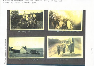
Photograph - Photocopy of four photographs of the Crawford Family in Grenville 1920s, B/W images of the Crawford Family in Grenville 1920's, July 3 1996
... ...Braeside...The Family 1922, Ron Sweetland's Party 1922, Braeside Woolshed, Eastern View...Buninyong & District Historical Society Old Court House, Buninyong Town Hall 313 Learmonth Street Buninyong goldfields B/W copies of the Crawford family and property at Grenville in the early 20th century Images of a local family and property in the early 20th century Grenville Crawford Family Braeside Woolshed The Family 1922, Ron Sweetland's Party 1922, Braeside Woolshed, Eastern View B/W photographs of the Crawford family and property of Grenville circa 1920s B/W images of the Crawford Family in Grenville 1920's Photograph Photocopy of four photographs of the Crawford Family in Grenville 1920s ...B/W copies of the Crawford family and property at Grenville in the early 20th centuryImages of a local family and property in the early 20th centuryB/W photographs of the Crawford family and property of Grenville circa 1920sThe Family 1922, Ron Sweetland's Party 1922, Braeside Woolshed, Eastern Viewgrenville, crawford family, braeside, woolshed -
 Ringwood and District Historical Society
Photograph, Arthur Blood's house, 15 Braeside Avenue, Ringwood, circa 1960s
... Arthur Blood's house, 15 Braeside Avenue, Ringwood, circa 1960s...Arthur Blood's house, 15 Braeside Avenue, Ringwood, circa 1960s Photograph ...The building has no Heritage Overlay. Arthur was Mayor of Ringwood for many years. -
 Ringwood and District Historical Society
Photograph, Arthur Blood's house, 15 Braeside Avenue, Ringwood, circa 1960s
... Arthur Blood's house, 15 Braeside Avenue, Ringwood, circa 1960s...Arthur Blood's house, 15 Braeside Avenue, Ringwood, circa 1960s Photograph ...The building has no Heritage Overlay. Arthur was Mayor and Councillor of Ringwood for many years. -
 Ringwood and District Historical Society
Photograph, Arthur Blood's former house, 15 Braeside Avenue, Ringwood, circa 1960s
... Arthur Blood's former house, 15 Braeside Avenue, Ringwood, circa 1960s...Arthur Blood's former house, 15 Braeside Avenue, Ringwood, circa 1960s Photograph ...The building has no Heritage Overlay. Arthur was Mayor and Councillor of Ringwood for many years. -
 Ringwood and District Historical Society
Photograph, Maroondah Highway East, Ringwood- 1969. New Civic Centre being built in Braeside Ave
... New Civic Centre being built in Braeside Ave....New Civic Centre being built in Braeside Ave. Photograph ...Black and white photographWritten on back of photograph: "New municipal offices being built". -
 Ringwood and District Historical Society
Photograph, Maroondah Highway East, Ringwood- 1969. New Civic Centre being built in Braeside Ave
... New Civic Centre being built in Braeside Ave....New Civic Centre being built in Braeside Ave. Photograph ...Black and white photographWritten on back of photograph: "New municipal offices being built." -
 Ringwood and District Historical Society
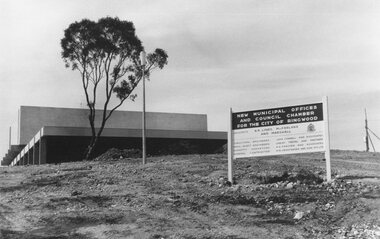
Photograph, Maroondah Highway East, Ringwood- 1969. New Civic Centre being built in Braeside Ave
... New Civic Centre being built in Braeside Ave....New Civic Centre being built in Braeside Ave. Photograph ...Black and white photographSign on construction site reads: New Municipal Offices and Council Chamber for the City of Ringwood. Also shows names of Architects and other Contractors. -
 Ringwood and District Historical Society
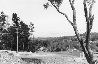
Photograph, Maroondah Highway East, Ringwood- 1969. Looking north from Braeside Ave towards Loughnan's Hill
... Looking north from Braeside Ave towards Loughnan's Hill....Looking north from Braeside Ave towards Loughnan's Hill. Photograph ...Black and white photographWritten on back of photograph: "From Civic Centre, Nov 1969. -
 Ringwood and District Historical Society
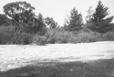
Photograph, Former antimony mine site, prior to becoming site of Maroondah Civic Centre, Braeside Avenue, Ringwood - 1963
... Former antimony mine site, prior to becoming site of Maroondah Civic Centre, Braeside Avenue, Ringwood - 1963....Ringwood and District Historical Society 125A Warrandyte Road Ringwood North melbourne Black and white photograph Former antimony mine site, prior to becoming site of Maroondah Civic Centre, Braeside Avenue, Ringwood - 1963. Photograph ...Black and white photograph -
 Ringwood and District Historical Society
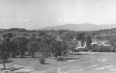
Photograph, Series of photographs taken from roof of Civic Centre in Braeside Avenue Ringwood East, 1973. (14 images)
... Series of photographs taken from roof of Civic Centre in Braeside Avenue Ringwood East, 1973. (14 images)...Series of photographs taken from roof of Civic Centre in Braeside Avenue Ringwood East, 1973. (14 images) Photograph ...Written on backing sheet, "Looking from roof of Civic Centre across sports grounds, Ringwood East, 1973". -
 Ringwood and District Historical Society
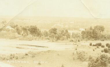
Photograph, Ringwood Birdseye - Looking towards Ringwood from later site of Civic Centre in Braeside Avenue, Ringwood East
... Ringwood Birdseye - Looking towards Ringwood from later site of Civic Centre in Braeside Avenue, Ringwood East....Ringwood Birdseye - Looking towards Ringwood from later site of Civic Centre in Braeside Avenue, Ringwood East. Photograph ...Typed below photograph, "Looking towards Ringwood from present site of Civic Centre. Old Catholic Church which stood on Maroondah Hwy. and Mt. Dandenong Rd. intersection can be seen on right. Maroondah Hwy. can be seen where it goes past lake, also station masters residence, and houses in Pitt St. and Bedford Rd." -
 Ringwood and District Historical Society
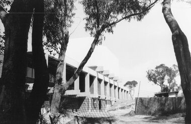
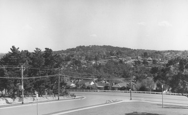
Photograph, View from Civic Centre, Braeside Avenue, overlooking Maroondah Highway towards Loughnan's Hill - 1973
... View from Civic Centre, Braeside Avenue, overlooking Maroondah Highway towards Loughnan's Hill - 1973...View from Civic Centre, Braeside Avenue, overlooking Maroondah Highway towards Loughnan's Hill - 1973 Photograph ...Black and white photograph looking towards T-intersection towards housing and trees on hill. -
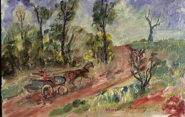 Federation University Art Collection
Oil painting, Neville Bunning, 'The Dalveen Braeside Road' by Neville Bunning
... 'The Dalveen Braeside Road' by Neville Bunning...The Art Collection features over 1000 works and was listed as a 'Ballarat Treasure' in 2007. art artwork to be framed horse and carriage neville bunning Signed bottom centre Neville M Bunning Small painting depicting horse and carriage with driver moving along a country road. 'The Dalveen Braeside Road' by Neville Bunning Oil painting Neville Bunning ...This item is part of the Federation University Art Collection. The Art Collection features over 1000 works and was listed as a 'Ballarat Treasure' in 2007.Small painting depicting horse and carriage with driver moving along a country road.Signed bottom centre Neville M Bunningart, artwork, to be framed, horse and carriage, neville bunning -
 University of Melbourne, Burnley Campus Archives
Booklet, Braeside Metropolitan Park, 1985-1987
... Braeside Metropolitan Park...Master Plan Report September 1987 Braeside Metropolitan Park Booklet Found in the Cottage, former residence of Poultry Curator in 2019 ...parks, hon a mccutcheon -
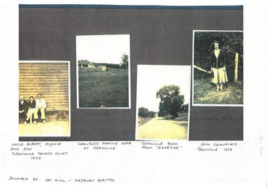 Buninyong & District Historical Society
Photograph - Photocopy of four photographs of the Crawford Family in Grenville 1930s, B/W images of the Crawford Family in Grenville 1930's, July 3 1996
... ...Braeside...Grenville Road from "Braeside". Jean Crawford Grenville 1933....Grenville Road from "Braeside". Jean Crawford Grenville 1933. B/W photographs of the Crawford family and property of Grenville circa 1933 B/W images of the Crawford Family in Grenville 1930's Photograph Photocopy of four photographs of the Crawford Family in Grenville 1930s ...B/W copies of the Crawford family and property at Grenville in the early 20th centuryImages of a local family and property in the early 20th centuryB/W photographs of the Crawford family and property of Grenville circa 1933Uncle Albert, Euphie and Don Grenville Tennis Court 1933. Crawford Family Home at Grenville. Grenville Road from "Braeside". Jean Crawford Grenville 1933.grenville, crawford family, braeside -
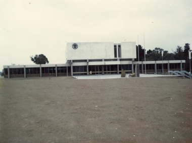 Ringwood and District Historical Society
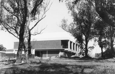
Photograph, City of Ringwood Civic Centre
... Photograph of Ringwood Civic Centre, Braeside Avenue, taken on 28th January 1970...Ringwood and District Historical Society 125A Warrandyte Road Ringwood North melbourne Photograph of Ringwood Civic Centre, Braeside Avenue, taken on 28th January 1970 City of Ringwood Civic Centre Photograph ...Photograph of Ringwood Civic Centre, Braeside Avenue, taken on 28th January 1970 -
 Melbourne Tram Museum
Functional object - Material sample, Lod Promotions, PTV logo with name stitched onto a black cloth, 2014?
... Material sample of the PTV logo with name stitched onto a black cloth by Lod Promotions of Braeside...Melbourne Tram Museum 8 Wallen Road Hawthorn melbourne Trams tramways PTV Logos Uniforms Marketing Material sample of the PTV logo with name stitched onto a black cloth by Lod Promotions of Braeside PTV logo with name stitched onto a black cloth Functional object Material sample Lod Promotions ...Material sample of the PTV logo with name stitched onto a black cloth by Lod Promotions of Braesidetrams, tramways, ptv, logos, uniforms, marketing -
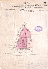 Ringwood and District Historical Society
Map, Subdivision Plan - Crown Allotment 20 Section E, Parish of Ringwood, Township of Ringwood, County of Mornington. (Undated, circa 1920s)
... Wax/parchment paper printout of numbered subdivision allotments and store, corner of Mount Dandenong Road and Braeside Avenue, Ringwood....Wax/parchment paper printout of numbered subdivision allotments and store, corner of Mount Dandenong Road and Braeside Avenue, Ringwood. Subdivision Plan - Crown Allotment 20 Section E, Parish of Ringwood, Township of Ringwood, County of Mornington. ...Wax/parchment paper printout of numbered subdivision allotments and store, corner of Mount Dandenong Road and Braeside Avenue, Ringwood.Rubber-stamped with circa 1920s stamp of W.J. Bonwick, Licensed Surveyor, 19 Clarence Street, East Malvern, Telephone U4833.