Showing 5 items matching "brick area for cowes"
-
 Phillip Island and District Historical Society Inc.
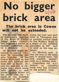
Newspaper Clipping, 21/11/1968
... ...brick area for cowes...Article about the Shire of Phillip Island's councillors rejecting a notice of motion for the extension of the brick area in Cowes....Phillip Island and District Historical Society Inc. phillip-island-and-the-bass-coast Article from a collection of newspaper clippings from October 1968 to July 1971 phillip island phillip island shire council brick area for cowes Article about the Shire of Phillip Island's councillors rejecting a notice of motion for the extension of the brick area in Cowes. ...Article from a collection of newspaper clippings from October 1968 to July 1971Article about the Shire of Phillip Island's councillors rejecting a notice of motion for the extension of the brick area in Cowes.phillip island, phillip island shire council, brick area for cowes -
 Phillip Island and District Historical Society Inc.
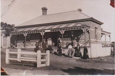
Photograph, 1920
... Cowes Post Office, corner Main Street and The Esplanade. A brick building with corrugated iron roof, two brick chimneys, a porch extending across front verandah, wooden posts, awning roof striped. Fencing across with free access above four steps. Ten figures on verandah and in front with hats, bags and jackets. Women with long skirts and dresses. In foreground a small fenced area...Cowes Post Office, corner Main Street and The Esplanade. A brick building with corrugated iron roof, two brick chimneys, a porch extending across front verandah, wooden posts, awning roof striped. Fencing across with free access above four steps. Ten figures on verandah and in front with hats, bags and jackets. Women with long skirts and dresses. In foreground a small fenced area ..."Waiting to meet the Boat". Cowes Post Office, corner Main Street and The Esplanade. A brick building with corrugated iron roof, two brick chimneys, a porch extending across front verandah, wooden posts, awning roof striped. Fencing across with free access above four steps. Ten figures on verandah and in front with hats, bags and jackets. Women with long skirts and dresses. In foreground a small fenced area.9 women and 1 man, elegantly dressed, standing outside a brick building with 2 verandahs. This is the first Cowes Post Office, on the corner of the Esplanade and Thompson Ave, Cowes.local history, photographs, buildings - historic, post office, black & white photograph, mary robb -
 City of Melbourne Libraries
Photograph, Bull, Hugh Jones, 1897-1993, Poultry auction for Christmas dinners, Bentleigh Poultry Market
... area next to a large shed with a high verandah. Two horse drawn vehicles are visible in the background, as well as five motorised vehicles. There are stacks of wooden boxes or crates which look as if they transport birds, and two cows are grazing by the fence. There are two telegraph poles with many lines. In the adjacent block is a very large car business comprising two large brick...area next to a large shed with a high verandah. Two horse drawn vehicles are visible in the background, as well as five motorised vehicles. There are stacks of wooden boxes or crates which look as if they transport birds, and two cows are grazing by the fence. There are two telegraph poles with many lines. In the adjacent block is a very large car business comprising two large brick ...Published: Age (Melbourne, Vic.: 1854- ), Thursday 21 December 1933, page 11 Published title: : POULTRY FOR CHRISTMAS DINNERS Published caption: With the approach of the Festive Season, the demand for poultry of all descriptions tends to harden and good clearances of many thousands of birds have been effected at recent auctions. The above picture was taken yesterday at the sale conducted by Messrs. Parnham and Carter of Bentleigh, whose auctions are the largest in Melbourne on the basis of individual sales. The auctioneer's assistant is holding up a prime goose for the appraisement of bidders preparing for Christmas fare. Trove article identifier: http://nla.gov.au/nla.news-article203351699 Research by project volunteer, Louise McKenzie: This photo is full of action! A poultry auction is in full flight. The serious-looking auctioneer and his assistant stand on a Parnham & Carter wooden box so that the auctioneer can make eye contact with the bidding crowd. The auctioneer is wearing a waistcoat and tie and has his pencil and paper ready to record the winning bids. The assistant in overalls is holding a live white duck in each hand. Two other assistants also hold live birds. A wire cage on the ground holds a few white chickens – presumably the next auction items. The majority of the substantial crowd is male, mostly wearing Fedora hats and jackets or suits and ties. Some women are present, wearing hats and coats, and at least seven children are visible, some dressed up, others dressed more casually. The auction is taking place in a rural setting, possibly on the site where the birds are farmed. It is an informal, rather rough, grassed area next to a large shed with a high verandah. Two horse drawn vehicles are visible in the background, as well as five motorised vehicles. There are stacks of wooden boxes or crates which look as if they transport birds, and two cows are grazing by the fence. There are two telegraph poles with many lines. In the adjacent block is a very large car business comprising two large brick warehouse style buildings, plus outbuildings. The signage on one brick warehouse mentions Standard Cars. Both a man and a woman have their arms raised to bid. It is an occasion – but a serious one. We cannot be sure if these birds are for breeding or the table, but buying poultry for the Christmas meal was a tradition in Melbourne with purchasers going either to the auctions, or perhaps the Queen Victoria Market. The Argus in its article “Christmas Dinner” on 6 December 1932 advised of increased demand for turkeys and chickens ahead of a possible Christmas shortage. Part of this shortage would be because of the outbreak of Newcastle disease which resulted in a quarantine around Melbourne within which all killing must be under supervision and bear the Government brand. They believed this would result in smaller producers not bothering to get such a permit as "for many of them the poultry cheque is only pin money for their wives.” Interestingly, an article in the Sun News Pictorial of 26 January 1934 reported a strong market, and “One auctioneer stated that buyers were taking up chickens freely now for the Centenary celebrations because they would probably never be as plentiful at the present levels of prices until next season.” That same article quoted officials of the Department of Agriculture stating that "…they had received a fair number of inquiries from farmers recently on the possibilities of table poultry breeding for local and export markets. The good prices being paid for poultry were attracting interest.” In fact, on 29 December 1933, the Sun News-Pictorial had reported that for the first time, the innovation of holding poultry sales in Melbourne between the Christmas and New Year holidays had been trialled the day before, and had proved successful. The Bentleigh area had a long history of poultry farming. The Seal of the Municipality of Moorabbin has a cockerel featured in the top right quadrant, and according to its local history website, “Writers in the local press gave advice on breeding, feeding, marketing and other matters of concern to anyone keeping fowls. In 1914 poultry farms were spread from Ormond, through Cheltenham and Mentone to Mordialloc.” The Encyclopedia of Melbourne online advises that the Shire of Moorabbin once covered an extensive area of the south-eastern suburbs, land where the Boon wurrung people had hunted, fished and collected water from the natural springs near Beaumaris and Cheltenham. The Boon wurrung reputedly called this district Mooroobin, a name that Richard and John King adapted to Moorabbin for the cattle run they established in the mid-1840s. The sandy soil of much of the district proved suitable for market gardening which flourished in Moorabbin from the 1850s. Some districts, such as Highett, remained largely devoted to cattle, while fishing was a major activity in the coastal villages. Moorabbin's population remained tiny throughout the 19th and much of the early 20th century with less than 1000 ratepayers in the shire. When the more popular coastal resort areas of the shire seceded after World War I, Moorabbin was left as an under-serviced, still largely rural area. It was not until the 1930s that the population rose above 20,000. By the late 1930s poultry farming had been added to market gardening as a local industry. But northern sections of the city, such as Bentleigh and McKinnon, were beginning to develop as residential areas. The local council took steps to attract industry and new residents to the city by erecting reputedly the largest neon sign in Melbourne at the time on the Point Nepean Road (later Nepean Highway), pointing out that plentiful residential and industrial land was available. The era of gardeners’ picnics, the formation of the Market Gardeners’ & Fruit Growers’ Association, and the Moorabbin Horticultural, Poultry & Dog Society Spring Shows was over. References: POULTRY SALES HELD (1933, December 29). The Sun News-Pictorial (Melbourne, Vic. : 1922 - 1954; 1956), p. 20. Retrieved July 30, 2024, from http://nla.gov.au/nla.news-article276124760 MUCH INTEREST IN POULTRY (1934, January 26). The Sun News-Pictorial (Melbourne, Vic. : 1922 - 1954; 1956), p. 30. Retrieved July 30, 2024, from http://nla.gov.au/nla.news-article277292695 Christmas Dinner. (1932, December 6). The Argus (Melbourne, Vic. : 1848 - 1957), p. 6. Retrieved July 30, 2024, from http://nla.gov.au/nla.news-article4512606 'Moorabin', eMelbourne, https://www.emelbourne.net.au/biogs/EM01004b.htm 'City of Glen Eira Thematic Environmental History [Refresh] 2020', prepared for The City of Glen Eira by Built Heritage P/L, https://www.gleneira.vic.gov.au/media/7583/glen-eira-c214glen-city-of-glen-eira-thematic-environmentla-history-refresh-2020.pdf Photographer notations on slide: "Poultry for Christmas Dinners Age 21-12-33 B9".christmas, poultry -
 Surrey Hills Historical Society Collection
Photograph, Grovedale Road Quarry in the 1920s - looking south, c1920
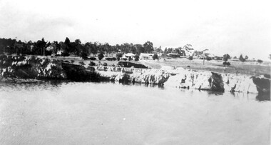
... Clay was quarried from part of this area and used to make the bricks used in the construction of his home, known as 'Ancyra'. This is still extant at the corner of Weybridge and James Streets. Maling grazed cows...Clay was quarried from part of this area and used to make the bricks used in the construction of his home, known as 'Ancyra'. This is still extant at the corner of Weybridge and James Streets. Maling grazed cows ...The quarry was part of John Butler Maling's property. He was one of the original settlers of the area and farmed the area between Weybridge Street and Whitehorse Road. Clay was quarried from part of this area and used to make the bricks used in the construction of his home, known as 'Ancyra'. This is still extant at the corner of Weybridge and James Streets. Maling grazed cows and used the quarry as a water source. He was the uncle of John Butler Maling, Mayor of Camberwell. He was married to Kate Conlon in 1882. They had 3 children: Silas Young, Alick and Zillah. Maling was born in c1829 in Shepreth, Cambridgeshire; he died in Surrey Hills on 9 October 1912 and is buried in Box Hill Cemetery - CE-*-0586. Mrs Kate Maling (born c1859 in Co Meath, Ireland) died at the property on 8 March 1921. She is buried in Brighton General Cemetery. Probate was valued at over 10,000 pounds and included other properties in Sandringham, Hawthorn and Macedon. At the time of her death the Surrey Hills property was described as being 23 acres with 2 brick houses, 1 cow, 2 heifers and 40 fowls or chickens. The property was subdivided after her death. The property was subdivided into 110 house blocks in c1923 - see Maling's Estate subdivision flyer on the State Library of Victoria's website. This shows that the Grovedale Park site had been acquired by Camberwell Council by this time. An attached newspaper clipping documents prices realised for a cross-section of blocks. The MMBW map of 1925, also on the SLV website, shows the outline of the clayhole / quarry. The quarry was filled in after several drownings or near drownings and the land is now occupied by a park and playground, known as Grovedale Road Park, maintained by the City of Boroondara. Beckett Park is sited on horizon to the left beyond the trees. This documents the landscape prior to close settlement and is material to early building and farming in the Surrey Hills area.Black and white photo of the quarry between Grovedale Road and James Street taken in the 1920s and looking south. In the foreground is an area of water with reeds in the LH corner. Beyond on the high banks there are single storey houses in the background and (?) some light poles. An object that looks like a tank on posts is in a cutting on the far bank.quarries, grovedale road, james street, clay quarries, farming, kate conlon, kate maling, john butler maling, ancyra -
 Surrey Hills Historical Society Collection
Photograph, Grovedale Road Quarry in the 1920s - looking north, c1920
... Clay was quarried from part of this area and used to make the bricks used in the construction of his home, known as 'Ancyra'. This is still extant at the corner of Weybridge and James Streets. Maling grazed cows...Clay was quarried from part of this area and used to make the bricks used in the construction of his home, known as 'Ancyra'. This is still extant at the corner of Weybridge and James Streets. Maling grazed cows ...The quarry was part of John Butler Maling's property. He was one of the original settlers of the area and farmed the area between Weybridge Street and Whitehorse Road. Clay was quarried from part of this area and used to make the bricks used in the construction of his home, known as 'Ancyra'. This is still extant at the corner of Weybridge and James Streets. Maling grazed cows and used the quarry as a water source. He was the uncle of John Butler Maling, Mayor of Camberwell. He was married to Kate Conlon in 1882. They had 3 children: Silas Young, Alick and Zillah. Maling was born in c1829 in Shepreth, Cambridgeshire; he died in Surrey Hills on 9 October 1912 and is buried in Box Hill Cemetery - CE-*-0586. Mrs Kate Maling (born c1859 in Co Meath, Ireland) died at the property on 8 March 1921. She is buried in Brighton General Cemetery. Probate was valued at over 10,000 pounds and included other properties in Sandringham, Hawthorn and Macedon. At the time of her death the Surrey Hills property was described as being 23 cres with 2 brick houses, 1 cow, 2 heifers and 40 fowls or chickens. The property was subdivided after her death. The quarry was filled in after several drownings or near drownings and the land is now occupied by a park and playground maintained by the City of Boroondara. Beckett Park is sited on horizon to the left beyond the trees. This documents the landscape prior to close settlement and is material to early building and farming in the Surrey Hills area.Black and white photo of the quarry between Grovedale Road and James Street taken in the 1920s and looking north. In the foreground is an area of water with high banks dividing the horizontal centre. Beyond are paddocks and trees behind which is a row of at least 3 single-storey houses. Light poles can be seen along a distant street. There are many mature trees in the background. The houses and trees are positioned along Whitehorse Road in the vicinity of Westminster Street. Shadows indicate the photo was taken in early morning or evening.quarries, grovedale road, james street, surrey hills, balwyn, clay quarries, ancyra, kate conlon, kate maling, john butler maling, farming