Showing 3 items matching "brushy creek (mooroolbark)"
-
 University of Melbourne, Burnley Campus Archives
Document - Survey, Roger Lord, 1998
... ...Brushy Creek (Mooroolbark)...University of Melbourne, Burnley Campus Archives 500 Yarra Boulevard Richmond melbourne roger lord Melbourne Water Waterways weed management Brushy Creek (Mooroolbark) Survey form on educational and career information Roger Lord Document Survey ...Survey form on educational and career informationroger lord, melbourne water, waterways, weed management, brushy creek (mooroolbark) -
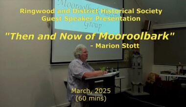 Ringwood and District Historical Society
Mixed media - Video, RDHS Meeting Presentation - "Then and Now of Mooroolbark" - Marion Stott OAM
... The Parish of Mooroolbark was surveyed in 1855, with a township originally called Brushy Creek standing where North Croydon is today. ...Ringwood and District Historical Society 125A Warrandyte Road Ringwood North melbourne The Parish of Mooroolbark was surveyed in 1855, with a township originally called Brushy Creek standing where North Croydon is today. ...Digitised video (3.68GB). Duration: 62 minutes. Recorded March, 2025 (Video is available for viewing at Ringwood & District Historical Society Archives by appointment)The Parish of Mooroolbark was surveyed in 1855, with a township originally called Brushy Creek standing where North Croydon is today. The name "Mooroolbark" was to be popularised with eventual European settlement in the late 19thy century. A rural hub developed around the train station, which opened in 1887 and offered rail access to Melbourne, with the Post Office opened shortly after in 1888. In this video presentation, Marion Stott, OAM, President and Founding Member of the Mooroolbark History Group, provides "Then and Now" details of all this and more. As well as activities in promoting local history, Marion is actively involved in local RSL, Traders group, and community events including Mooroolbark Red Earth Festival. For services to the community of Mooroolbark, Marion was awarded an OAM in 2020. -
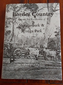 Mont De Lancey
Book, G.F. James, Border Country - Episodes and Recollections of Mooroolbark & Wonga Park, 2984
... Mooroolbark became the West Riding of today. The book is a historical account of these Victorian suburbs, commissioned by the Shire of Lillydale. It documents the area's development through personal stories, maps, and photographs, detailing the evolution of these communities. Inside the left of the front cover at the top is a black stamp: ' Mont de Lancey Historical Homestead & Museum Wandin' A brown book with a grey dust jacket featuring an old photograph of a bullock team and wagon, Birt's Hill, Brushy Creek. ...The book is a historical account of these Victorian suburbs, commissioned by the Shire of Lillydale. It documents the area's development through personal stories, maps, and photographs, detailing the evolution of these communities.A brown book with a grey dust jacket featuring an old photograph of a bullock team and wagon, Birt's Hill, Brushy Creek. A farmer, Michael Smith stands at the horse's head. The title and author are printed in black lettering at the top with Shire of Lillydale printed in white at the bottom with a white outline of the shire coat of arms. The spine has all details in black lettering. The back of the book's end paper has a list of the Shire of Lillydale West Riding Councillors. The blurb on the back end paper gives an outline of the contents inside. There is a Preface, Contents, Acknowledgements, and Index at the back. Inside are photographs, maps, advertisements and detailed information about the early days of settlement and development up to the 1980's. Pp. 96.non-fictionThe book is a historical account of these Victorian suburbs, commissioned by the Shire of Lillydale. It documents the area's development through personal stories, maps, and photographs, detailing the evolution of these communities.